Showing 599 items matching "lookouts"
-
 Lakes Entrance Historical Society
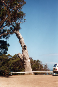
Photograph - Lookout tree, 1990
Colour photograph of the old lookout tree on Jemmys Point, showing a standing dead grey box tree, remains of three branches at top which once held a platform and signal structure. Two timber seats on lawn at base, roadway in foreground. Lakes Entrance, Victoria,historic sites, navigation -
 Bendigo Historical Society Inc.
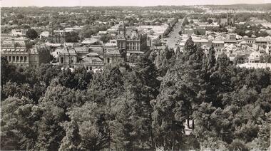
Photograph - LA TROBE UNIVERSITY BENDIGO COLLECTION: BENDIGO STREETSCAPE
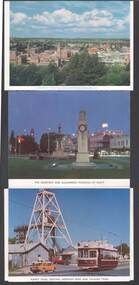
BHS CollectionA black and white photo of Bendigo taken from the Lookout Tower in Rosalind Park. The Post Office and Courthouse are in the foreground. The view includes looking up Williamson Street from Pall Mall with the Shamrock Hotel on the corner. This photo was obtained from 'The Argus' newspaper date unknown.photograph, streetscape, bendigo, la trobe university bendigo collection, collection, bendigo, scenery, photograph, photographs, photography, photo, williamson street , streetscape, lookout tower, rosalind park, pall mall, the argus -
 Lakes Entrance Historical Society
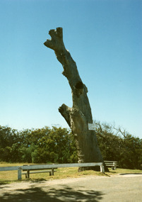
Photograph, Lookout tree on Jemmys Point Lakes Entrance Victoria, 1990
Colour photograph of the old lookout tree on Jemmys Point, showing a standing dead grey box tree, remains of three branches at top which once held a platform and signal structure. Two timber seats on lawn at base, roadway in foreground. Lakes Entrance, Victoria,historic sites, navigation -
 Lakes Entrance Historical Society
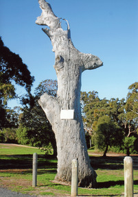
Photograph, old lookout tree on Jemmys Point, Lakes Entrance, 1990
Colour photograph of the old lookout tree on Jemmys Point, showing a standing dead grey box tree, remains of three branches at top which once held a platform and signal structure. Two timber seats on lawn at base, roadway in foreground. Lakes Entrance, Victoria,historic sites, navigation -
 Halls Gap & Grampians Historical Society
Photograph - B/W
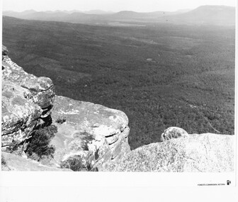
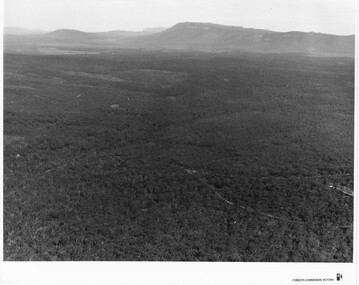
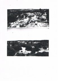
Photo is of the "Victoria Valley" taken from around the area of Reed's Lookout. The body of water is Moora Moora Reservoir. The background range is Victoria Range. Photo is typical of promotional photos taken by Forests Commission VictoriaRocky outcrop in foreground and a large, thick tree covered valley, with mountain ranges in the background. A body of water (near top, middle) and some roads can be seen c1960sscenery, grampians ranges -
 Halls Gap & Grampians Historical Society
Photograph - B/W
Photo is of Victoria Valley with Moora Moora Reservoir and the Victoria Range in the background. Photo would have been taken from around Reed's lookout area. Photo typical of promotional photos of the time by Forests CommissionLarge, densely treed valley with a body of water in background. Some roads can be seen particularly right foreground. There is a mountain range in the background. c1960sscenery, grampians ranges -
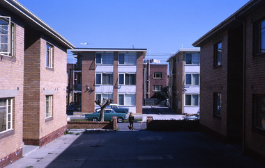
 Robin Boyd Foundation
Slide, Robin Boyd, 1965
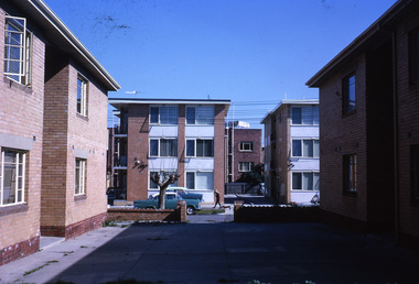
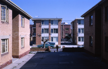
Robin Boyd has written 'Australiana' on the slide mount (item S1081) at the same location. Robin Boyd was always on the lookout for signage and blots on the landscape, especially when writing and illustrating his 1960 book, “The Australian Ugliness”.Colour slide in a mount. Flats, AustraliaMade in Australia / 13 / AUG 65M / Encircled 2 (Handwritten) / Australiana 2 (Handwritten) / 10 (Handwritten) / Encircled 2 (Handwritten)australia, slide, robin boyd -
 Robin Boyd Foundation
Slide, Robin Boyd, 1965
Robin Boyd has written 'Australiana' on the slide mount (item S1081) at the same location. Robin Boyd was always on the lookout for signage and blots on the landscape, especially when writing and illustrating his 1960 book, “The Australian Ugliness”.Colour slide in a mount. Flats, AustraliaMade in Australia / 14 / AUG 65M / Encircled 31 (Handwritten)australia, slide, robin boyd -
 Robin Boyd Foundation
Slide, Robin Boyd, 1965
Robin Boyd has written 'Australiana' on the slide mount (item S1081) at the same location. Robin Boyd was always on the lookout for signage and blots on the landscape, especially when writing and illustrating his 1960 book, “The Australian Ugliness”.Colour slide in a mount. Flats, AustraliaMade in Australia / 15 / AUG 65M / Encircled 10 (Handwritten)melbourne, slide -
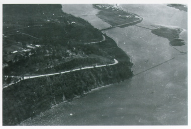 Lakes Entrance Historical Society
Photograph - Kalimna, Bulmer H D, 1940c
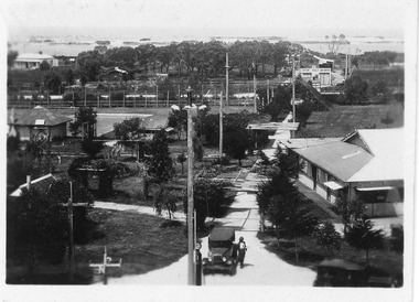
Black and white photograph of aerial view of Kalimna Heights, showing scattered buildings, Princes Highway around side of cliff, western end of township, North Arm bridge, footbridge to Bullock Island, and rock groynes. Track to lookout and signal beacon visible. Lakes Entrance Victoria waterways, roads and streets, bridges, township -
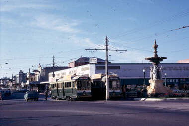 Ballarat Tramway Museum
Slide - 35mm slide/s set of 7, Noel Simons, 29 Feb. 1972
Set of 7 transparencies taken on 29/2/1972 on Kodak mounts. 1208.1 - Bendigo 18 (en route to Quarry Hill) and 2 (Eaglehawk) in the early morning at Charing cross with the Alexandra fountain and the Fountain Plaza building in the background. 1208.2 - No. 2 descending View St. Photo taken after tram has passed the photographer. 1208.3 - as for 1208.2 at Mackenzie St. intersection 1208.4 - No. 26 ascending View St. with the ANZ bank, T& G in the background. 1208.5 - as for 1208.4, but at Mackenzie St. intersection. Photo taken after tram has passed the photographer. 1208.6 - No. 18 in View St. seen from the lookout tower in Rosalind Park. 1208.7 - No. 7 en route to North Bendigo in Nolan St. Photographed across the Centenary Oval.Information written on in blue ink and date stamped on purple ink. 1208.1 - "Nos. 18 and 2 in the early morning sun at Charing Cross." 1208.2 - "No. 2 descending View St. towards Charing Cross." 1208.3 - "No. 2 in View St. passing Mackenzie St." 1208.4 - "No. 26 in View St. just after leaving Charing Cross." 1208.5 - "No. 26 climbing View St. past Mackenzie St." 1208.6 - "No. 18 climbing View St. seen from lookout tower in Rosalind Park." 1208.7 - "No. 7 in Nolan St. heading towards North Bendigo. / Last picture of a Bendigo tram."tramways, trams, bendigo, charing cross, view st., nolan st., tram 2, tram 7, tram 18, tram 26 -
 Ballarat Tramway Museum
Slide - Bendigo bogie car - Bernard & View Sts from lookout tower, Ron Hood, 12/1970
Colour photograph of a Bendigo bogie tram about to turn from Bernard St into View St. Taken from the lookout or mine poppet tower. Has the Queen Victoria Oval grandstand in the foreground and a BP service station in the view.Yields information about Bendigo tram operations and locations - December. 1970Colour slide in hanimount cardboard mount.Numbered "Bendigo" and slide number 23 in ink.tramways, trams, bendigo, bernard st, view st -
 Bendigo Historical Society Inc.
Newspaper - LONG GULLY HISTORY GROUP COLLECTION: LANDSCAPE PHOTOS
Two pages of photocopies of photos, four of landscape photos and one of what looks like drums in a bunker. Two of the photos are scenes of mining areas, one has bush, buildings and poppet legs and one is a view of the town area taken from a lookout. There are two people leaning on the fence.bendigo, history, long gully history group, the long gully history group - landscape photos, mining areas -
 Bendigo Historical Society Inc.
Postcard - BENDIGO - FOLD-OUT VIEW
Fold-out views of Bendigo, including a panorama from the lookout tower, Bendigo Pottery, Pall Mall, Conservatory Gardens, Poppet head Central Deborah, Cenotaph, Joss House, Alexandra Fountain, interior Chinese Joss House, Sun Loong, Easter Parade. Appears to be 1970's ?bendigo, streetscape, bendigo, postcards. -
 Lakes Entrance Historical Society
Photograph - Lookout tree c1910, 1910
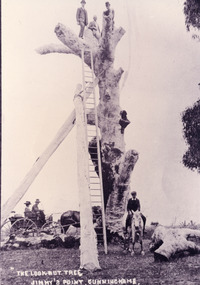
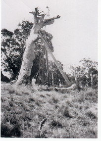
On back of original 'What price our Yankees climbing trees?'Black and white photograph copied from a postcard showing three men on top of the LookOut Tree at Jemmys Point, tree supported by two logs, 35 foot ladder against tree for access on top, man and woman in buggy and boy on horse watching photographer. Lakes Entrance, Victoriahistoric sites, navigation -
 Lakes Entrance Historical Society
Photograph - Whiter's Camp Park, 1928c
Also postcard size black and white same scene but larger view with two vehicles, with inscription-General view Lakes camping park showing homestead.|Larger copy has the inscription Beautiful view of park from Whiters Lookout Tower.Black and white photograph of Whiters Park, showing residence and office, gardens, tennis court, early model car by the petrol bowser, electric lights on tall poles. Opposite park entry is Aults Motor Engineer, scattered cottages. In distance is Cunninghame Arm, sand hummocks and ocean. Lakes Entrance Victoriaresort, township, transport, recreation -
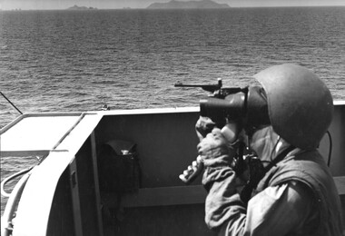 National Vietnam Veterans Museum (NVVM)
Photograph, Gibbons, Denis, Lookout
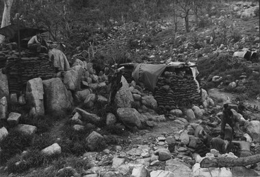
Denis Gibbons (1937 – 2011) Trained with the Australian Army, before travelling to Vietnam in January 1966, Denis stayed with the 1st Australian Task Force in Nui Dat working as a photographer. For almost five years Gibbons toured with nine Australian infantry battalions, posting compelling war images from within many combat zones before being flown out in late November 1970 after sustaining injuries. The images held within the National Vietnam Veterans Museum make up the Gibbons Collection.A black and white photograph of a crew member keeping lookout on a deck of HMAS Hobart during a fire mission into Vinh, a major choke point in North Vietnam, where convoys were formed for the move into South Vietnam. A forward air controller from USS Hancock was directing the fire from the air.photograph, hmas hobart, vinh, uss hancock, tonkin gulf, 7th fleet, gibbons collection catalogue, denis gibbons, photographer, vietnam war, crew members -
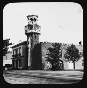 City of Ballarat Libraries
Glass Slide, Ballarat City Fire Station
This image shows the elaborate lookout tower which has since had the cantilevered section removed. The face stonework has since been covered with cement render. The residence next door is believed to have been built for Dr. R. Pinnock, in 1877.Previously unknown image of Ballarat. The set and its subjects indicate these images were produced to promote Ballarat and were perhaps aimed at tourists.Ballarat City Fire Station, nw corner Sturt and Raglan Streets, erected 1860. telegraph pole -
 Clunes Museum
Photograph, 2000
.1 6 colour photographs of the opening of Wesley College showing the public and the band outside the college .2 two helicopters on Clunes oval - arriving of the dignitaries for the opening .3 Photograph from lookout at Scenic Drive .4 two photographs of Service Street, showing the cars parked for the opening of Wesley College .1 opening /4/00 Kodak Premium, Processing April 2000 .2 Opening Wesley /4/00 .3 High crane Wesley Campus 1999 .4 Opening Wesley 2/4/00wesley college, scenic drive, service street -
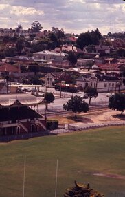
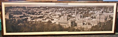 Bendigo Historical Society Inc.
Photograph - BENDIGO CITY TAKEN FROM LOOKOUT TOWER
BHS CollectionTimber framed, cream mount, black and white photograph of Bendigo City. Written on bottom of photograph: ' The City from the Lookout Tower'. In foreground of photo - Shamrock Hotel; Law Courts; Post Office building. On extreme right of photo, Williamston Street. In extreme foreground, trees in Rosalind Park and Pall Mall.bendigo, streetscape, pall mall and city -
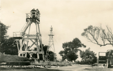 Lakes Entrance Historical Society
Postcard - Lookout tower Jemmy's Point, 1940
Black and white small format postcard of the timber observation lookout at Jemmys Point, Lakes Entrance, Victoria, showing the updated and safer steps from ground to observation deck, with fenced landing at halfway point. Old log and seat still nearby, signal light on steel tower a short distance away.historic sites, navigation, fences -
 National Vietnam Veterans Museum (NVVM)
Photograph, Gibbons, Denis, Horseshoe Feature 1
Denis Gibbons (1937 – 2011) Trained with the Australian Army, before travelling to Vietnam in January 1966, Denis stayed with the 1st Australian Task Force in Nui Dat working as a photographer. For almost five years Gibbons toured with nine Australian infantry battalions, posting compelling war images from within many combat zones before being flown out in late November 1970 after sustaining injuries. The images held within the National Vietnam Veterans Museum make up the Gibbons Collection. A black and white photograph of fortifications and a lookout post at the 'Horseshoe Feature' . The Diggers in the lower right-hand corner of the photograph are clearing an area between a large rock crevice to construct their fortified bunker. The 'Horseshoe Feature' was regularly mortared and rocketed by the NVA/VietCong. The feature served as an interdiction site.(Circa early 1967)photograph, digger, horseshoe feature, nva/vc, gibbons collection catalogue, denis gibbons, photographer, vietnam war, diggers -
Bendigo Historical Society Inc.
Photograph - MERLE HALL COLLECTION: ROSALIND PARK CREATIVE VILLAGE BENDIGO PROJECT PHOTOS, 1995
Merle Hall Collection: Rosalind Park Creative Village Bendigo Project Photos August and September 1995 39 Photos of the project beginning, mosaic workshops, preliminary works at the lookout tower in Rosalind Park and completion. Photos are cotained in 10 plastic wallets (four photos per wallet) labelled 3858.2a to 3858.2j -
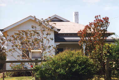 Lakes Entrance Historical Society
Photograph - Housing, 1999
Typical of J C Dahlsen house plan, built 1929 - 1930 by Dahlsen's for A J Legg and family. Mrs M E Legg operated it as 'Kalimna Gardens Tea Rooms' for a few years.Colour photograph of a dwelling at Lookout Road, Kalimna. Lower third of walls weatherboard, upper walls fibro cement. Hip roof of corrugated iron, gablet ventilator at roof ridge, gable over projecting front room. Bullnose veranda has been enclosed on south side. Kalimna Lakes Entrance Victoriahouses, architecture -
 Bendigo Historical Society Inc.
Document - MERLE HALL COLLECTION: DOCUMENTS RELATING TO HERITAGE MOSAIC
Various documents relating to Heritage Mosaic project Bi-fold A4 flyer : Bendigo Heritage Mosaic - Rosalind Park Lookout includes description, background and illustrative sketch of Mosaic area; List of contacts re possible Mosaic Project 7/3/01 a list of Bendigo facilities contacted and agreed to letters of support; form letter dated 3/8/2001to agencies/organizations re support for submission for series of small mosaic pieces along the Linear Pathway adjacent to the Bendigo Creek; memo to Bernard Smith from Judy MacDonald (BRAC) re plans for Lookout Mosaic (with the attached design details from Maery Hall (3 sheets of sketches and photograph are said to be attached but not now). -
 Lakes Entrance Historical Society
Photograph - Lookout tree, 1927
Black and white photograph of the Lookout Tree on Jemmys Point showing a standing dead grey box tree supported by two long timbers. Access to the top via a 35 foot ladder. Thelma Roder standing on top beside signal structure, two women and child standing near base. Lakes Entrance Victoria,historic sites, navigation -
 Greensborough Historical Society
Bath and bed head (remnants), Partington family, remnants of bath and bed head, 1900c
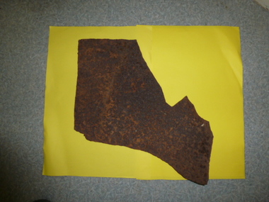
This piece of an old bath dates back to the late 1800s to early 1900s. The bath would have been used by the Partington or Bosch families at the property at Point Lookout. This piece is from a bath that was used by our grandfather (born in 1872) when the family lived at Point Lookout before the Partington family bought Willis Vale in 1878. The bath remnant was retrieved after fire destroyed the house. Bed head (remnant): From the Willis Vale homestead. The Partingtons purchased Willis Vale in 1878. William James Partington (1872-1941) and his wife Annie May (1874-1965). They were the parents of Eva, Grace, Alan, Jess and Jack. All except Eva were born at Willis Vale. 9from Faye Fort)Remnants of two of the Partington family homes, both destroyed by fire.Cast-iron, rusted. Section of base of bath and one upright post from bed head.partington, bosch, willis vale, lookout point, baths, bed heads, furniture, greensborough -
 Lakes Entrance Historical Society
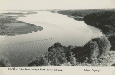
Postcard, Bulmer Collection, Reeves Channel ,Rigby Fraser and Flannigan Islands Lakes Entrance, 1931
People in Third photo are Keith and Gladys Scarce 1931Black and white postcard showing Reeves Channel in the Gippsland Lakes between timbered cliffs to the North and Rigby Fraser and Flannigan Islands to the South, taken from Jemmys Point Lakes Entrance Victoria. Also a similar view taken from Kalimna . Third photo of people near the lookout tree Jemmy's Point Lakes Entrancegippsland lakes -
 Forests Commission Retired Personnel Association (FCRPA)
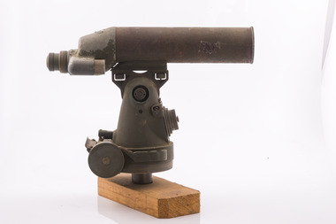
Telescope used in FCV fire towers - ex military, c 1940s
Victoria once had well over one hundred fire lookouts and firetowers. Fire lookouts, or observation posts, were often just a clearing on a hill or a vantage point, whereas firetowers were definite structures. Many were established by the Forests Commission Victoria (FCV) in the 1920s, but the network was expanded rapidly in response to recommendations of the Stretton Royal Commission after the 1939 Black Friday bushfires. When a fire or smoke was spotted from the tower a bearing was taken with the alidade and radioed or telephoned into the district office. It was then cross referenced with bearings from other towers on a large wall map to give a "fix" on the fire location Alidades and telescopes were used in the post war period but were replaced with a much simpler map table and reference string suspended from the centre of the tower cabin.Uncommon usageTelescope used in fire towers Ex military Kern Company NY Argus made in USA Adjustment lens, dials and focus ring Small spirit levelbushfire, forests commission victoria (fcv) -
 Forests Commission Retired Personnel Association (FCRPA)
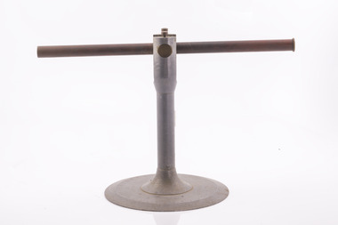
Alidade - sight tube used in FCV fire towers, c 1940s
Victoria once had well over one hundred fire lookouts and firetowers. Fire lookouts, or observation posts, were often just a clearing on a hill or a vantage point, whereas firetowers were definite structures. Many were established by the Forests Commission Victoria (FCV) in the 1920s, but the network was expanded rapidly in response to recommendations of the Stretton Royal Commission after the 1939 Black Friday bushfires. When a fire or smoke was spotted from the tower a bearing was taken with the alidade and radioed or telephoned into the district office. It was then cross referenced with bearings from other towers on a large wall map to give a "fix" on the fire location Alidades and telescopes were used in the post war period but were replaced with a much simpler map table and reference string suspended from the centre of the tower cabin.Uncommon usageAlidade Sight TubeFCV and bearing markers on the alloy base. Very simple design. bushfire, forests commission victoria (fcv)