Showing 991 items
matching map of the world
-
 Ballarat Clarendon College
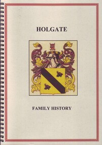
Book, L J Richard Mooney, Origin and history of the Holgate family, 2014
Family history referencing old collegians George Holgate (1891), Stephen Holgate (1895), Harry (1896), Edward (1906), Robert (1908) and Thomas (1911). Spiral bound A4 book; coloured illustrations, maps and graphs; 61p. george holgate, stephen holgate, harry holgate, edward holgate, robert holgate, thomas holgate, world war one, ballarat college -
 Bendigo Military Museum
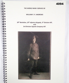
Literary work - BOOK, Jan Andrews, The WW1 Service of William F.P. Andrews
The World War 1 service of William.F.P.Andrews 38th Batt, 3rd Div AIF and 3rd Div Signals Company AIF. He enlisted on 27.3.1916, No 57, age 19 years 6 months in the 38th Batt HQ, embark for England 20.6.1916, embark for France 22.11.1916, hospital 16.12.1916 with Bronchitis, rejoin unit 23.12.1916, transfer to 3rd Div Signals 25.4.1917, hospital 11.1.1918 with Influenza, rejoin unit 23.1.1918, hospital 20.5.1918 with Impetigo/Dermatitis, rejoin unit 12.7.1918, discharged from the AIF 12.12.1919.Book, spiral bound with black metal, cover cardboard black print and illustrated in sepia tone of a soldier in uniform, rear cover has a postcard photo, 101 pages, plain white paper, illustrated B & W and colour, diagrams, maps and photo of medals.books, 38th batt aif, world war 1 service -
 Bendigo Military Museum
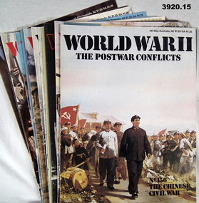
Magazine - MAGAZINE COLLECTION WW2, Orbis Publishing Ltd, World War II The Postwar Conflicts, 1981
Also see Reg No's 3909.6, 3910.56, 3919.15 & 3921.Magazine collection not in binder. Paper cover with black / white / colour print. Illustrated in colour. Cut, plain, white pages. Illustrated black / white / colour photos, maps, etc. 300 pages Volume I2 Part No 156 to Part No 170magazine, collection -
 Bendigo Military Museum
Book - BOOK, EPITAPHS WW1, We Will Remember Them, AIF Epitaphs of World War I
We Will Remember Them, AIF Epitaphs of World War I. From back cover: No consolidated list of epitaphs exists but John and Hazelle Laffin have been collecting them from the graves themselves for decades. These inscriptions, in their great variety, present a picture of Australians of the period.Soft cardboard cover. Black, white & gold print on front, spine & back. On front cover background is a sepia photo of a soldier in uniform with his wife & 2 children. Smaller colour photo in foreground of a headstone. On back cover is a small colour photo of John & Hazelle Laffin. 158 pages, cut, plain, white. Illustrated black & white photos & hand drawn maps. Hand written notes in grey lead pencil on numerous pages.books-military-history, epitaphs ww1 -
 Bendigo Military Museum
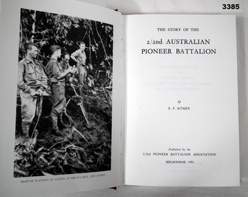
Book - BOOK WW2, 2/2nd Australian Pioneer Battalion, 1953
From page following title page: "2/2 Pioneer Battalion History. To the memory of All Ranks of the 2/2 Pioneer Battalion who were killed or died, as free men or prisoners during the Second World War" Refer Cat No 4072.2P, John Donald (Jock) VX19003, POW twice. Hard cover, cardboard, buckram, dark red colour, gold print on spine. 228 pages, cut plain white. Illustrated with black & white photos & maps. Front & back fly leaf & end papers illustrated, grey & white drawing of a scene with trees & soldiers in action. book, 2/2nd, pioneer -
 Bendigo Military Museum
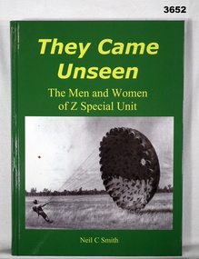
Book - BOOK, WW2, Neil C Smith, They Came Unseen, 2010
They Came Unseen - The men and women of 2 Special Unit. From back cover: Secret operations behind enemy lines in the Pacific War during World War Two were vital in winning he war against the Japanese. Author: Lieutenant Colonel Neil C Smith, AM” Hard cardboard cover, gloss paper. Yellow print on front spine & back. Green background, illustrated front cover, black / white photo of soldier with parachute. Back cover has colour photo of 2 Special Unit Association ANZAC Day March. 264 cut, plain, white pages. Illustrated black / white photos & maps. Handwritten on title page in black ink: “Neil Smith”book, z special, came unseen -
 Bendigo Military Museum
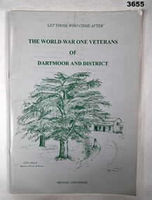
Booklet - BOOKLET, WW1, Michael Greenham, The World War One Veterans of Dartmoor & District, Post 1990 possibly
... with black / white photos. End papers front & back. Illustrated maps ...Soft, cardboard cover. Light grey background with green print & illustrations of trees on front & back. Stapled. 96 cut, glossy white pages. Illustrated with black / white photos. End papers front & back. Illustrated maps. Inscriptions.Handwritten in black ink on title page: “Michael Greenham. Anzac Day 1995”booklet, dartmoor ww1 -
 Bendigo Military Museum
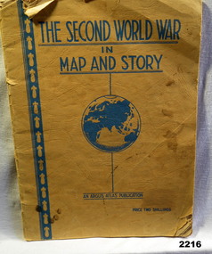
Book - BOOK WW2, The Second World War in Map and Story, During the WW2
... The Second World War in Map and Story... of history with full page map every 2nd page. The Second World War ...Covers are yellow/orange with all writing in blue. Title at top, globe depiction of the world central at bottom "An Argus Production, Price Two shillings. 63 pages of history with full page map every 2nd page.books, maps, story -
 Bendigo Military Museum
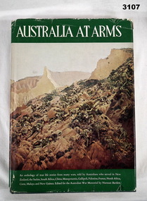
Book - BOOK, MILITARY HISTORY, Norman Bartlett, Australia at Arms, 1962
An anthology of true life stories as told by Australians who served in New Zealand, South Africa, World War I & II.Hard, green, buckram cover embossed with gold shield surrounded by laurel wreath. Dust jacket with colour illustration on front. Title in white print on green background. Title in gold print on spine. End papers illustrated in green with maps & figure of soldiers. 265 pages with cut edges & black & white photos & drawings.books-biography, military history, photography, illustrations -
 Federation University Historical Collection
Book - Booklet, Soldiering On: The Australian Army at Home and Overseas, 1942
Belonged to Clarence (Clarrie) Edward Nicholls who was a communications person on the Sunderland Flying Boats. He was in the Battle of Britain. He was seconded to the RAF and flew out of Plymouth. He was shot down a number of times. He was in the peace keeping corps in Japan and then Korea, and then went into the full time Korea. At one time Clarrie and his two brothers were in New Guinea at the same time. They knew they were all there together but they could not find each other, and officials would not tell them where they were. He flew the last Sunderland back to Lake Boga. He wanted to buzz his parents in Wodonga so he knew he was on the way, but the authorities wouldn't let him. Clarrie Nicholls was a flag bearer for the Melbourne Olympics.Red hard covered book of 200 pages. The following images are by official war artist Geoff Mainwaring (SX13471) who later taught painting at the Ballarat Technical Art School. * 'And Again. So-Heave', page 121 * 'Day's Work Done', page 121 * Untitled image, pg 185 Includes photographs of General Sir Thomas Blamey, Corporal Jim Gordon, John Lavarack, Iven Maccay, Australian Women's Army Service, Convalescent Diggers at Heidelberg Hospital; and maps of the Malay Peninsula and Singapore.clarence nicholls, nicholls, world war 2, geoffrey mainwaring, new guinea, singapore, libya, solomon islands, charles bush, ivor heale, g.j. browning -
 Bendigo Military Museum
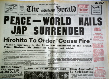
Newspaper - NEWSPAPERS WW11, 1) The Herald Sun & Myer, 1) 15.8.95
.1) Newspaper, reprint of The Herald, Wed August 15th 1945. Headlines: Peace - World Hails Jap Surrender, 16 pages in total, souvenir edition. .2) - .3) Newspaper reprints from the Adelaide Advertiser, August 12th 1914, pages 9-12, photograph details, maps of the Wars beginning.documents - newspapers, herald, advertiser -
 Bendigo Military Museum
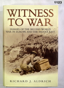
Book, Witness to War. Diaries of the Second World War in Europe and the Middle East, 2004
Witness to War - a retelling of the war experience through the private diaries kept by people from all walks of life and from many countries. Hard cover, black colour buckram, gold print on spine. Dust cover gold and black print on front, back and spine, background sepia colour photograph of military scene. Black and white photograph of military personnel and people. End papers - illustrated with diary pages. 720 pages cut plain. Illustrated black and white photographs and maps.On first front title page - hard written black ink "Len Burke" "Donated by Len Burke family" Owners stamp black ink "Len Burke"/ 11/290 St Aidens Road, Bendigo, Vic. 3550 documents-diaries, military history -
 Bendigo Military Museum
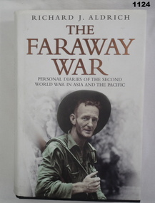
Book, The Faraway War. Personal Diaries of the Second World War in Asia and the Pacific
Hard cover - Black with author and title in gold on spine. White dust cover - photo of solder on front and six photos on back. 704 pages - illustrated - 7 mapsDonated by Len Burke on fly leafdocuments-diaries, military history -
 Bendigo Military Museum
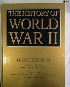
Book, Lt Colonel E Bauer, The History of World War II, c.2000
The History of World War II, hard cover book. Gold background, black box with gold lettering for the title. Author's name in black ink at bottom, 1024 pages. Illustrated with maps, & black & white & coloured photos.Donated by Bendigo Y's Mens Clubbooks, military history -
 Bendigo Military Museum
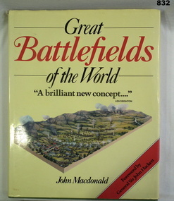
Book, John Macdonald, Great Battlefields of the World, 1984
Book, green buckram with gold print & dust jacket. Jacket background is yellow with red & black print & 3D drawing of a battlefield. 200 pages. Illustrated with maps, 3D drawings & photos.From Bishop Noel Daly's collections 2004books, military, history -
 Bendigo Military Museum
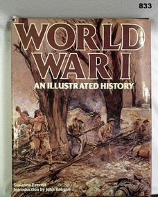
Book, Colporteur Press, World War I An Illustrated History, 1984
Photographic record of the World War I years & theatres of war. Maps of various battles are also included. An introduction to the book was written by John Keegan.Brown, buckram hard cover with title in gold lettering on spine. Brown dust cover with illustrations front & back. Title in brown & white on front & spine of dust cover. 256 pages with cut edges. Contains black & white illustrations. Brown end papers.books-military-history, illustrations -
 Federation University Historical Collection
Book - Astronomy, Richard A. Proctor, Other Worlds Than Ours: The Plurality of Worlds Studied under the Light of Recent Scientific Researches, 1878
Richard Anthony Proctor (23 March 1837 – 12 September 1888) was an English astronomer who produced one of the earliest maps of Mars in 1867 from 27 drawings by the English observer William Rutter Dawes. He used old drawings of Mars dating back to 1666 to try to determine the sidereal day of Mars. His final estimate, in 1873, was 24h 37m 22.713s, very close to the modern value of 24h 37m 22.663s. Proctor was already a well-known populariser of science when he published this book, joining a ferocious debate about the possibility of life on other planets. The crater Proctor on Mars is named after him.Red hard covered book of 318 pages. Includes early images of planets as seen through a J. Browning Telescope. Proctor discusses Victorian discoveries about the solar system and describes what was then known about each of the planets. He evaluates the habitability of Mars, Jupiter, Mercury, Venus and Saturn in the light of his belief in the possibility of extraterrestrial life. The text includes many illustrations of the planets, a spectacular map of Mars, and theoretical views of the Milky Way. Influenced by Darwin, Proctor had a teleological view of the universe and believed that eventually the cosmos would be filled with living things. non-fictionRichard Anthony Proctor (23 March 1837 – 12 September 1888) was an English astronomer who produced one of the earliest maps of Mars in 1867 from 27 drawings by the English observer William Rutter Dawes. He used old drawings of Mars dating back to 1666 to try to determine the sidereal day of Mars. His final estimate, in 1873, was 24h 37m 22.713s, very close to the modern value of 24h 37m 22.663s. Proctor was already a well-known populariser of science when he published this book, joining a ferocious debate about the possibility of life on other planets. The crater Proctor on Mars is named after him.astronomy, planets, telescope, earth, sun, jupitar, saturn, uranus, neptune, moon, meteors, comets, solar system, nebulae, galaxies, milky way -
 Frankston RSL Sub Branch
Medallions, ANZAC, 50th Anniversary of Gallipoli Medallions
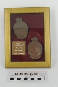
Two medallions which were awarded to Australian World War 1 servicemen, T ENGLISH and C R C FERGUSSON, who had landed at Gallipoli in 1915. These medallions have been mounted on a burgundy felt backing and framed in a small gold coloured photo frame. Each is a circular bronze medallion surmounted by the Queen's crown. Obverse depicts Simpson and his donkey assisting a wounded man, a laurel wreath, the date '1915' and the word 'ANZAC'. Reverse depicts a map of Australia and New Zealand with the Southern Cross superimposed, fern fronds and the engraved name of the recipient. The Anzac Medallion was issued by the Australian government in 1967 to commemorate the 1965 50th anniversary of the Gallipoli landings. The medallion was issued to surviving veterans of the campaign or their next of kin. Refer to AWM item for further information < http://www.awm.gov.au/collection/RELAWM16790.001/ >There is an engraved label mounted within the picture frame with the inscription "ANZAC Medallions", "Issued to Tom English & C R C Fergusson".anzac, ww1, 1915, world war 1, gallipoli medallion -
Frankston RSL Sub Branch
Rule, Scale, E. ESDAILE & SONS, 1942
A scale rule used by artillery units to measure distance between map co-ordinates on the 1 to 25,000 scale military map series. The rule is accurately machined from flat stainless steel strip and is stamped with Imperial measurements (thousands of yards) and metric measurements (thousands of metres).The rule is stamped with the following: "SCALE, ARTY, No 2, MKI, E.ESDAILE & SONS, D^D, 1942"artillery, rule, scale, imperial, metric, distance, world war 2, ww2, -
Frankston RSL Sub Branch
Pocketbook, Souvenir, Taschenbuch Groß-Deutschland, Geschichtstafel, Deutschlands Wehrmacht, Weltatlas, 31 August, 1941
... , German military units and insignia and world maps, 1942 calendar... units and insignia and world maps, 1942 calendar, etc ...provenance unknownSmall, soft cover, pocketbook presumably souvenired from a German soldier during the latter stages of World War 2. The pocketbook is of the type originally issued by the German military and was printed in August 1941, edited by Georg Westermann, Braunschweig. The book has a red coloured cover with black printing and contains 48 pages. Pages are printed in black, the maps are printed in colour. The pocketbook is in good condition, some pages have tears and the cover is scuffed. The pocket book title translates as "Paperback Greater Germany, History Chart, Germany's Wehrmacht, World Atlas" and is a collection of information about the German Reich, German military units and insignia and world maps, 1942 calendar, etc. The original owner has made markings on some maps and has made notes.The front cover is printed in black ink with the following "Taschenbuch Groß-Deutschland, Geschichtstafel, Deutschlands Wehrmacht, Weltatlas" -
Frankston RSL Sub Branch
Map, SECRET LANDING GROUNDS AUSTRALIA
... during the latter years of World War 2. The map is in Mercator... in use during the latter years of World War 2. The map ...Large map of aircraft landing grounds located in Australia and some nearby Islands. This map shows landing grounds in use during the latter years of World War 2. The map is in Mercator Projection to the Equatorial Scale 1:4,000,000. The scale is statute miles. Each landing ground location is shown by a symbol indicating category and name. The legend explains the landing ground categories: RAAF Main Landing Grounds, RAAF Emergency Landing Grounds, Seaplane Anchorages, Civil Main Landing Grounds, Civil Emergency Landing Grounds and Cancelled Landing Grounds. The map was revised 4th September, 1945. The map is printed on paper which is attached to a linen backing, The map is quite faded and in a fragile condition. -
 Wycheproof & District Historical Society Inc.
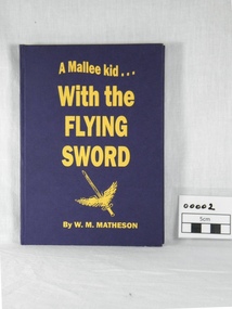
book, W.M. Matheson, A Mallee kid with the Flying Sword, 2004 (exact)
W.M. Matheson 409169 F/LT who lives at Wycheproof, relates his wartime experiences as a Flying Officer - William "Murdoch" Matheson made 194 operational flights and his accounts of missions and descriptions of different locations are interesting.An autobiographical account of service with the Royal Auxiliary Air Force in World War II. A hard covered blue book with gold inscription. Contents describe the author's overseas service in World War II. Two final chapters are the End of the War and Reflections. The Wycheproof Historical Society/With Best Wishes/Murdoch/409169 F/LT MATHESON WILLIAM MURDOCHno 601 county of london squadron, royal auxiliary air force, 1939 war, murdoch matheson, pilots foggia italy photo, italian war map, end of, the war 1945 -
 4th/19th Prince of Wales's Light Horse Regiment Unit History Room
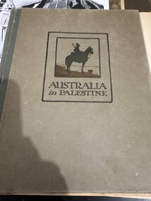
Book, Angus & Robertson Ltd, Australia in Palestine, 1919
Hard covered book. Stories of the Australians' campaign in Palestine in World War 1, with photos, drawings and mapsaustralian military history, palestine -
4th/19th Prince of Wales's Light Horse Regiment Unit History Room
Magazine Publication, Army Directorate of Public Relations, Salamaua Siege, 1943
Brochure Number 4 - "The Australian Army at War". An account of the Salamau campaign of World War 2 in the Pacific. With photos and mapsAn Official Publication -
 Flagstaff Hill Maritime Museum and Village
Document - Map, Department of Lands & Survey, Victoria / Panmure, 1942
... . It was printed in 1942 during World War II. It is one of two maps donated ...This Emergency Edition of the map of Panmure, Victoria, is part of the W.R. Angus Collection. It was printed in 1942 during World War II. It is one of two maps donated to Flagstaff Hill Maritime Village by the family of Doctor William Roy Angus, who served as Surgeon Captain in the Australian Defence Department. The map was compiled for the Dept. of Army by the Dept. of Lands and Survey in Melbourne, prepared by the Australian Section of the Imperial General Staff, which was a British Government body created in 1907 to co-ordinate the defence of Britain and its Empire. It was printed by A.H.Q. Cartographic Company, Survey Corps, which was formed in 1941. The Corp changed its name to L.H.Q. Cartographic Company of Bendigo. In 1947 the name reverted back to the A.H.Q. Cartographic Company until 1955 when it became the A.H.Q. Survey Regiment. The W.R. Angus Collection includes historical medical equipment, surgical instruments and material once belonging to Dr Edward Ryan and Dr Thomas Francis Ryan, (both of Nhill, Victoria) as well as Dr Angus’ own belongings. The Collection’s history spans the medical practices of the two Doctors Ryan, from 1885-1926 plus that of Dr Angus who began practice in 1924. Dr. Angus served with the Australian Department of Defence as a Surgeon Captain during the Second World Was from 1942 to 1945. He served in Ballarat, Victoria, and in Bonegilla, N.S.W. until he suffering from a heart attack just before the war ended. ABOUT THE “W.R.ANGUS COLLECTION” - Doctor William Roy Angus M.B., B.S., Adel., 1923, F.R.C.S. Edin.,1928, was generally known as Dr Roy Angus. His working life included a position as a doctor with the Flying Doctor Service in Australia’s rural and remote areas. After many varied experiences Dr Angus and his family moved to Warrnambool in 1939 where he purchased “Birchwood,” the 1852 home and medical practice of Dr John Hunter Henderson. He was appointed on a part-time basis as Port Medical Officer in Warrnambool and held this position until the 1940’s when the government no longer required the service of a Port Medical Officer. Dr Angus was a surgeon at the Warrnambool Base Hospital 1939-1942. After further studies he commenced practice as an ophthalmologist in Warrnambool, pioneering in artificial eye improvements. He was Honorary Consultant Ophthalmologist to Warrnambool Base Hospital for 31 years and made monthly visits to Portland to perform eye surgery. Dr Angus and his wife Gladys were very involved in Warrnambool’s community with a strong interest in civic affairs. They were both involved in the creation of Flagstaff Hill Maritime Village, including the layout of the gardens. After his death on 28th March 1970 his family requested his practitioner’s plate, medical instruments and some personal belongings be displayed in the Port Medical Office surgery at Flagstaff Hill Maritime Village, and be called the “W. R. Angus Collection”. This Emergency Edition of the Map of Panmure is significant as an example of the documents prepared for the defence of Australia in World War 2. The Map is also significant for its connection between the Australian Army and the involvement of Dr WR Angus as a Surgeon in the Medical Services during World War II. The W.R. Angus Collection is significant for still being located at the site it is connected with, Doctor Angus being the last Port Medical Officer in Warrnambool. The collection of medical instruments and other equipment is culturally significant, being an historical example of medicine, administration, household equipment and clothing from late 19th to mid-20th century. Dr Angus assisted Dr Tom Ryan, a pioneer in the use of X-rays and in ocular surgery. The collection includes Dr Angus’s Army objects and is significant as an example of items issued to Doctors and Surgeons in the Medical Services of the Australian Army in World War IIMilitary map of Panmure, Victoria, Australia; part of the W.R. Angus Collection. Rectangular coloured map on cream paper for the Australian Army. Details include sea, waterways and land, contour lines, grid lines, names of districts, towns and roads, bridges, swamps, rail lines, cuttings, tracks, buildings (including blacksmiths), pumps, lighthouses, telegraph, telephones and electric transmission lines, and fire stations. The map has margin notes that include distances in miles to nearby towns. The map was compiled for the Dept. of Army by the Dept. of Lands and Survey in Melbourne, prepared by the Australian Section, Imperial General Staff and printed by A.H.Q. Cartographic Company, Melbourne in 1942. Crown Copyright Reserved. Inscriptions in red print state that it is and Emergency Edition and an Official document. An oval purple stamp includes the price.Printed in black; 'Victoria / Panmure", "No. 930 / Zone 6" Printed in red; “EMERGENCY EDITION”, “THIS MAP IS AN OFFICIAL DOCUMENT. IF FOUND, IT MUST BE HANDED / IN TO THE NEAREST MILITARY HEADQUARTERS OR POLICE STATION” Stamped: within concentric ovals (“- - - FOR SALE / PRICE 2/- / - - - - - OF THE ARMY”)flagstaff hill, warrnambool, flagstaff hill maritime museum, maritime museum, shipwreck coast, flagstaff hill maritime village, great ocean road, dr w r angus, dr ryan, warrnambool base hospital, flying doctor, surgeon captain, australian department of defence, royal australian army, world war 2, map panmure 1942, roy angus, port medical officer, nhill base hospital, military map, emergency map, military service australian army, department of army, department of lands and survey, a.h.q. cartographic company melbourne, panmure 1942, australian section, imperial general staff -
 Flagstaff Hill Maritime Museum and Village
Document - Map, Department of Lands & Survey, Victoria / Port Campbell, 1942
... . It was printed in 1942 during World War II. It is one of two maps donated ...This Emergency Edition of the map of Port Campbell, Victoria, is part of the W.R. Angus Collection. It was printed in 1942 during World War II. It is one of two maps donated to Flagstaff Hill Maritime Village by the family of Doctor William Roy Angus, who served as Surgeon Captain in the Australian Defence Department. The map was compiled for the Dept. of Army by the Dept. of Lands and Survey in Melbourne, prepared by the Australian Section of the Imperial General Staff, which was a British Government body created in 1907 to co-ordinate the defence of Britain and its Empire. It was printed by A.H.Q. Cartographic Company, Survey Corps, which was formed in 1941. The Corp changed its name to L.H.Q. Cartographic Company of Bendigo. In 1947 the name reverted back to the A.H.Q. Cartographic Company until 1955 when it became the A.H.Q. Survey Regiment. The W.R. Angus Collection includes historical medical equipment, surgical instruments and material once belonging to Dr Edward Ryan and Dr Thomas Francis Ryan, (both of Nhill, Victoria) as well as Dr Angus’ own belongings. The Collection’s history spans the medical practices of the two Doctors Ryan, from 1885-1926 plus that of Dr Angus who began practice in 1924. Dr Angus served with the Australian Department of Defence as a Surgeon Captain during the Second World Was from 1942 to 1945. He served in Ballarat, Victoria, and in Bonegilla, N.S.W. until he suffering from a heart attack just before the war ended. ABOUT THE “W.R.ANGUS COLLECTION” - Doctor William Roy Angus M.B., B.S., Adel., 1923, F.R.C.S. Edin.,1928, was generally known as Dr Roy Angus. His working life included a position as a doctor with the Flying Doctor Service in Australia’s rural and remote areas. After many varied experiences Dr Angus and his family moved to Warrnambool in 1939 where he purchased “Birchwood,” the 1852 home and medical practice of Dr John Hunter Henderson. He was appointed on a part-time basis as Port Medical Officer in Warrnambool and held this position until the 1940’s when the government no longer required the service of a Port Medical Officer. Dr Angus was a surgeon at the Warrnambool Base Hospital 1939-1942. After further studies he commenced practice as an ophthalmologist in Warrnambool, pioneering in artificial eye improvements. He was Honorary Consultant Ophthalmologist to Warrnambool Base Hospital for 31 years and made monthly visits to Portland to perform eye surgery. Dr Angus and his wife Gladys were very involved in Warrnambool’s community with a strong interest in civic affairs. They were both involved in the creation of Flagstaff Hill Maritime Village, including the layout of the gardens. After his death on 28th March 1970 his family requested his practitioner’s plate, medical instruments and some personal belongings be displayed in the Port Medical Office surgery at Flagstaff Hill Maritime Village, and be called the “W. R. Angus Collection”. This Emergency Edition of the Map of Port Campbell is significant as an example of the documents prepared for the defence of Australia in World War 2. The Map is also significant for its connection between the Australian Army and the involvement of Dr WR Angus as a Surgeon in the Medical Services during World War II. The W.R. Angus Collection is significant for still being located at the site it is connected with, Doctor Angus being the last Port Medical Officer in Warrnambool. The collection of medical instruments and other equipment is culturally significant, being an historical example of medicine, administration, household equipment and clothing from late 19th to mid-20th century. Dr Angus assisted Dr Tom Ryan, a pioneer in the use of X-rays and in ocular surgery. The collection includes Dr Angus’s Army objects and is significant as an example of items issued to Doctors and Surgeons in the Medical Services of the Australian Army in World War IIMilitary map of Port Campbell, Victoria, Australia; part of the W.R. Angus Collection. Rectangular coloured map on cream paper for the Australian Army. Details include sea, waterways and land, contour lines, grid lines, names of districts, towns and roads, bridges, swamps, rail lines, cuttings, tracks, buildings (including blacksmiths), pumps, lighthouses, telegraph, telephones and electric transmission lines, and fire stations. The map has margin notes that include distances in miles to nearby towns. The map was compiled for the Dept. of Army by the Dept. of Lands and Survey in Melbourne, prepared by the Australian Section, Imperial General Staff and printed by A.H.Q. Cartographic Company, Melbourne in 1942. Crown Copyright Reserved. Inscriptions in red print state that it is and Emergency Edition and an Official document. An oval purple stamp includes the price.Printed in black; 'Victoria / Port Campbell", "No. 932 / Zone 6" Printed in red; “EMERGENCY EDITION”, “THIS MAP IS AN OFFICIAL DOCUMENT. IF FOUND, IT MUST BE HANDED / IN TO THE NEAREST MILITARY HEADQUARTERS OR POLICE STATION” Stamped: within concentric ovals (“- - - FOR SALE / PRICE 2/- / - - - - - OF THE ARMY”)flagstaff hill, warrnambool, flagstaff hill maritime museum, maritime museum, shipwreck coast, flagstaff hill maritime village, great ocean road, dr w r angus, dr ryan, warrnambool base hospital, nhill base hospital, flying doctor, surgeon captain, map port campbell 1942, roy angus, port medical officer, military map, emergency map, australian department of defence, royal australian army, military service australian army, department of army, department of lands and survey, world war 2, a.h.q. cartographic company melbourne, australian section, imperial general staff, port campbell 1942 -
 Flagstaff Hill Maritime Museum and Village
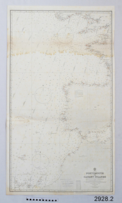
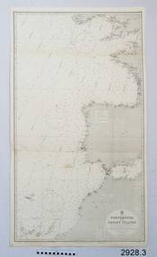
Document - Navigation Chart, Portsmouth to Canary Islands, CA. 1928
Navigation charts are drawn by professional hydrographers and describe the geography of land and water, enabling a water based navigator on board vessels such as ships to safely negotiate between ports locally and around the world. They are drawn to a particular standard with common symbols noting landmarks. The charts are used in conjunction with other navigational instruments and tools to calculate the vessel’s exact location and a safe route to its destination.The set of charts and their chart are of significance as examples of equipment and documents used to navigate the oceans of the world, particularly to Australia. Migration to Australia is an important part of this country's history.British Admiralty Navigation Chart - Portsmouth to Canary Islands - printed on rectangular white paper. Published in London by the British Admiralty in 1928.warrnambool, shipwreck coast, flagstaff hill, flagstaff hill maritime museum, flagstaff hill maritime village, chart, map, navigate, navigation, location, vessel, 1928, british admiralty, hydrographer, geography, admiralty chart, portsmouth, canary islands -
 Flagstaff Hill Maritime Museum and Village
Document - Navigation Chart, Portsmouth to Canary Islands, Ca. 1928
This is an Official British Admiralty Navigation Chart, one of a set of 65 charts donated together with a wooden chart case. It was published and printed in London in 1928 by the British Admiralty. Navigation charts are drawn by professional hydrographers and describe the geography of land and water, enabling a water based navigator on board vessels such as ships to safely negotiate between ports locally and around the world. They are drawn to a particular standard with common symbols noting landmarks. The charts are used in conjunction with other navigational instruments and tools to calculate the vessel’s exact location and a safe route to its destination.The set of charts and their chart are of significance as examples of equipment and documents used to navigate the oceans of the world, particularly to Australia. Migration to Australia is an important part of this country's history.British Admiralty Navigation Chart - Portsmouth to Canary Islands - printed on rectangular white paper. Published in London by the British Admiralty in 1928.warrnambool, shipwreck coast, flagstaff hill, flagstaff hill maritime museum, flagstaff hill maritime village, chart, map, navigate, navigation, location, vessel, 1928, british admiralty, hydrographer, geography, admiralty chart, portsmouth, canary islands -
 Flagstaff Hill Maritime Museum and Village
Document - Navigation Chart, Eastern Part of the Celebes Sea, Ca. 1928
This is an Official British Admiralty Navigation Chart, one of a set of 65 charts donated together with a wooden chart case. It was published and printed in London in 1928 by the British Admiralty. Navigation charts are drawn by professional hydrographers and describe the geography of land and water, enabling a water based navigator on board vessels such as ships to safely negotiate between ports locally and around the world. They are drawn to a particular standard with common symbols noting landmarks. The charts are used in conjunction with other navigational instruments and tools to calculate the vessel’s exact location and a safe route to its destination.The set of charts and their chart are of significance as examples of equipment and documents used to navigate the oceans of the world, particularly to Australia. Migration to Australia is an important part of this country's history.British Admiralty Navigation Chart - Eastern Part of the Celebes Sea - printed on rectangular white paper. Published in London by the British Admiralty in 1928.warrnambool, shipwreck coast, flagstaff hill, flagstaff hill maritime museum, flagstaff hill maritime village, chart, map, navigate, navigation, location, vessel, 1928, british admiralty, hydrographer, geography, admiralty chart, celebes sea -
 Phillip Island and District Historical Society Inc.
Book, Bill Hampel, Against the grain : fourteen farmers adapt to climate change, 2015
Can we humans simply ignore the fires, the floods, and the increase in deaths brought about by climate change? In this book, Australian farmers - who bear the brunt of climate change, yet accept the science - share their experiences with the unpredictable weather events, the reduction in rainfall, and the shift to hotter months which are a challenge to farming cycles. Far from contributing to the problem with their farming practices, these farmers demonstrate how to reduce their greenhouse gases - to zero or below in some cases - while remaining profitable. They are all committed to pass on their farm in a better condition than when they first purchased or inherited it. With crops or livestock, big or small, they have worked cooperatively, mostly through land management, to plant thousands of trees, which has led to the daily presence of over 100 bird species. The farmers' inspiring and informative stories will open up a new world to most urban dwellers. A summary of climate change impacts - and an account of the numerous economic, political, and media barriers toward change - combine to provide a context for their work. 280 pages : colour illustrations, colour maps, colour portraits ; 23 cm. Includes bibliographical references and index. Also available in digital formats: ebook & epdf. ISBN 9781925078503 Dewey number 338.10994 Chapter 5 : Bob & Anne Davie Donor : Anne Davie ; Date : 14.10.2015.agriculture -- environmental aspects -- australia., farmers -- australia -- economic conditions., rural development -- australia., climatic changes -- australia.