Showing 11704 items matching "maps "
-
 Greensborough Historical Society
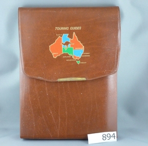
Road Maps, The Herald Road Guide, 1955-1956
... maps ...Contains maps of Melbourne and surrounding areas as well as routes from Melbourne to other state capitals.Contains maps and descriptions of the Melbourne area in the era before the large scale urbanisation after 1960. Also includes country and day tour maps before highways were common.Book of road maps, 271 pages, in brown plastic carry case.maps, melbourne, victoria, day tours, touring maps -
 Bendigo Historical Society Inc.
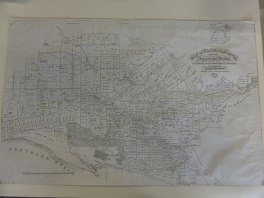
Map - PART PARISHES OF MANDURANG AND SANDHURST, No date visible
Map: Section of Parish plan of Bendigo covering Mandurang, Diamond Hill, and Quarry Hill, ( number 147 in Map Cupboard 1).Map 11map, bendigo, city streets, parish of mandurang, parish of sandhurst, diamond hill , quarry hill -
 Melbourne Tram Museum
Map, P. Sohns, "Strassenbahn Melbourne Gleisplan", 10-9-1992
... maps ...Map of Melbourne's tramway system prepared for a German audience - as at 28-5-1992. Shows the track layout, crossovers, depots, route numbers, railway/tramway level crossings, terminus details, road names and a CBD insert. Prepared by P Sohns of Germany - dated 10-9-1992.Yields information Melbourne tramways and routes in 1992.Map - A2 sheet folded to A4.tramways, maps, melbourne, germany -
 Melbourne Tram Museum
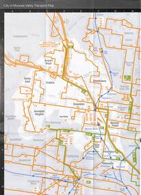
Map - Set of 3, Metlink, "Your Guide to Melbourne's Public Transport System - City of Manningham", c2005
... Maps ...Folded map titled "Your Guide to Melbourne's Public Transport System - City of Manningham", published by Metlink c2005. Has a map of transport routes in the City of Manningham, details of Metcards, bus routes, maps of the tram and train network and Metcard agents. 2 - as for .1, but for the City of Moonee Valley 3 - ditto for City of BoroondaraDemonstrates a map produced by Metlink for each municipality.Map - 18 fold - 6x3 - pocket size, printed in full colour.trams, tramways, maps, city of manningham, city of moonee valley, city of boroondara, metlink -
Whitehorse Historical Society Inc.
Map, Ringwood, 1935
... Maps ...Australia Ringwood and area map.Australia1:63,360 series map, Ringwood N.849 Zone 7. Scale 1 inch to 1 mile. Approximate scope: Prahran-Cockatoo, Lilydale-DandenongAustralia Ringwood and area map.maps, ringwood -
Bendigo Historical Society Inc.
Map - PART PARISHES OF MARONG AND LOCKWOOD, No date visible
Map: Section of Parish plan of Bendigo, covering Kangaroo Flat, Golden Square, and Specimen Hill ( number 146 in Map Cupboard 1)Map 10map, bendigo, city streets, parish of marong, parish of lockwood, kangaroo flat, golden square, specimen hill -
 Greensborough Historical Society
Book - Atlas, Victoria. Department of Sustainability and Environment, Melbourne atlas, 2006_
... maps ...The purpose of the Melbourne Atlas is to give a spatial view of physical , environmental, social, economic and cultural aspects of Melbourne which can be used in planning. It contains maps and graphs depicting many aspects of life in Melbourne. A snapshot of life in Melbourne in 2006.Various paging, text, illus., colour maps. Wire binding.melbourne, maps, town planning, social conditions -
 Marysville & District Historical Society
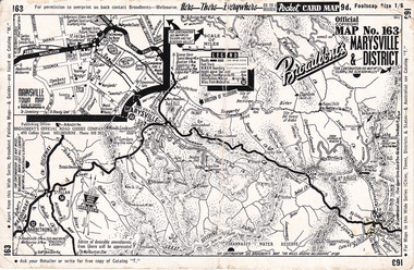
Ephemera (Item) - Pocket card map, Broadbent's Official Road Guides Company, Broadbent's Map No. 163 Marysville & District, 1950s
... maps ...A pocket card map of Marysville and the district. Drawn map of Marysville and the district. Has a legend, scale and a town map of Marysville. Gives an address for Broadbent's Publishing Office of 475 Collins St Melbourne and a Melbourne telephone number - MR 2021. Reverse has advertisements for Barton's Store and Marylands Guest House in Marysville.A pocket card map of Marysville and the district. Gives information about Marysville and the district. Broadbent's was a prolific publisher of maps. marysville, victoria, maps, broadbent's, barton's store, marylands guest house -
 Melbourne Tram Museum
Map, Ministry of Transport, Melbourne Public Transport Map - No. 11, 1980
... maps ...Map No. 11 dated on rear as 1980 - Includes description of tram and bus routes, private bus routes. Has contact details for bookings and lost property etc and how to use the map. Yields information about Melbourne public transport services in 1980Fold out map (27 sections 9 across x 3 deep), "Public Transport Map", coloured of Melbourne's Tram and Bus routes, route numbers, rail lines, detailed for the central part of Melbourne and the outer Metropolitan services.tramways, melbourne, tram services, bus services, railways, maps -
 Warrnambool and District Historical Society Inc.
Map, Warrnambool 1859, Late 20th century (copy)
This is a copy of Bromfield’s 1856 map of Warrnambool and district. James Astley Bromfield was a pioneer settler in Warrnambool. He established a chemist’s shop in 1854, initially situated in Timor Street. He moved his shop to Liebig Street with a new building erected in 1875. Bromfield was a prominent resident of Warrnambool (Shire Councillor, Fire Brigade member, Cricket Club member, associated with horse racing etc). He was interested in preserving the history of Warrnambool and this map he produced in 1856 was an example of this interest.This is a copy only but this 1856 map is of prime importance as it contains the names of the original landowners of land in north Warrnambool and the surrounding district. It is a frequently-used resource by historians.This is a copy of a map of Warrnambool and its agricultural district published by James Astley Bromfield in 1856. The map is mounted on cardboard and has black printing on a white background. ‘Map of Warrnambool and its Agricultural District according to the Government Survey’s published by Astley Bromfield, Medical Hall, Warrnambool 1856, James Ferguson, Lithr., Melbne.’bromfield’s 1856, map, warrnambool and district -
 Melbourne Tram Museum
Map, The Met, "Public Transport Map - No. 13", 1984
... maps ...Map No. 13 undated with the buzzing bee symbol on the front and throughout at the time of the introduction of the neighbourhoods. Includes description of tram and bus routes, private bus routes. Has contact details for bookings and lost property etc and how to use the map. Gives extensive details of the neighbourhood tickets and their used. C1984.Yields information about Melbourne public transport services in 1984.Fold out map (36 sections 9 across x 4 deep), "Public Transport Map", coloured of Melbourne's Tram and Bus routes, route numbers, rail lines, detailed for the central part of Melbourne and the outer Metropolitan services.tramways, melbourne, tram services, bus services, maps -
 Warrnambool and District Historical Society Inc.
Document, Map: Lady Bay 1853, 1853
This is one of the earliest surveys and maps of Warrnambool harbor, Lady Bay. Being done in 1853, it shows the depths of the bay area marked in fathoms, currents and directions and areas of rocks around mouth of the Merri and the Western side of the bay as well as a large sand spit to the middle right of the beach region.. It also marks the large areas of seaweed and fuci in the outer bay area. It has the area of Pertobe Lagoon marked and shows the early tracks to the town. The engraving work was done by Tulloch and Brown, with Tulloch being one of the earliest engravers and lithographers in the state of Victoria. He arrived in Melbourne in 1849 and set up business with James Davie Brown in 1853 with Brown being a map engraver. They were awarded bronze and silver medals for their work at the Victorian Industrial Exhibition. He also worked in the vignettes on the Proeschel Map of Victoria.This map is of high historical and comparitive significance as it shows the Lady Bay area prior to the changes that have occurred in the last 160 years with the building of the breakwater. The issue regarding access to Lady Bay remains a current one. The engraver D Tulloch engraved some of the earliest scenes of the goldfields in Ballarat and as such has left a record of a very early and important era in Australian history. Rectangular cream paper with black text. Map area is outlined by fine black lined border. Key in top right hand corner and scale at bottom middle of map.Map is labelled Town of Warrnambool printed at top of map. Small logo at top right corner which has “Hydrographic Department” in circle around an anchor. Lady Bay Warrnambool Surveyed by John Barrow assistant surveyor Engraved by Tulloch & Brown in bottom right corner. Melbourne engraved by order of the legislative Council of Victoria in middle bottom.map, warrnambool, town of warrnambool map 1853, tulloch & brown map 1853, lady bay warrnambool,, warrnambool harbour, warrnambool breakwater, warrnambool beach -
 Melbourne Tram Museum
Map, Ministry of Transport, Melbourne Public Transport Map - No. 9, 1979
... maps ...Map No. 9 - Includes description of tram and bus routes, private bus routes. Has contact details for bookings and lost property etc and how to use the map. Yields information about Melbourne public transport services in 1979Fold out map (27 sections 9 across x 3 deep), "Public Transport Map", coloured of Melbourne's Tram and Bus routes, route numbers, rail lines, detailed for the central part of Melbourne and the outer Metropolitan services.tramways, melbourne, tram services, bus services, railways, travelcard, maps -
Victorian Aboriginal Corporation for Languages
Book, Melway Publishing, Melway Greater Melbourne street directory : including Geelong, Phillip Island, Healesville, Kinglake, Gisborne, Lorne, Wallan, Bacchus Marsh, Bellarine &? Mornington Peninsulas, 2005
... maps ...Street directory including the wider area surrounding Melbourne.mapsmaps, victorian street maps, street directories, road maps -
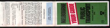
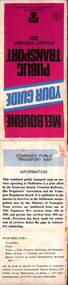
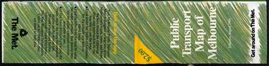
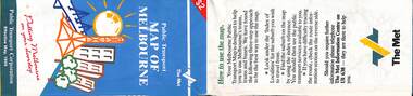
 Melbourne Tram Museum
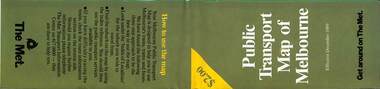
Map, The Met, Public Transport Map of Melbourne - Get around on The Met, 8/1990
... maps ...Melbourne transport map - dated August 1990 - includes a map of the ticket zones, and The Met contact details and notes where tickets can be obtained fromYields information about Melbourne public transport services in August 1990Fold out map (36 sections 9 across x 4 deep), "Public Transport Map of Melbourne", coloured of Melbourne's Tram and Bus routes, route numbers, rail lines, detailed for the central part of Melbourne and the outer Metropolitan services.tramways, melbourne, tram services, bus services, railways, maps, zones -
 Bacchus Marsh & District Historical Society
Map, Plan of Survey of Part of Crown Allotment 9, Parish of Korkuperrimul, 1890
This map documents a transfer of an allotment of land in Clarke Street Bacchus Marsh in 1890. Clarke Street is located on the eastern side of Bacchus Marsh not far from Main Street and Crook Street. It is now known as Candeloro Street. The map indicates J. Booth as the owner of the land and H. Simpson as the occupier. Next to this allotment is a an allotment of land owned by J. Elmore,Single page map showing Crown allotment 9, Parish of Korkuperrimul, County of Bourke. Scale 100 feet to inch. Part of a set of maps which are pasted into a bound volume containing 76 maps or plans in total. High resolution digital image stored on BMDHS computer network. At bottom of map: I hereby certify that I have made this survey expressly for the purpose of an application under the Transfer of Land Statute that this plan is correct. Barry B???, Lic. Surveyor, 16.10.90bacchus marsh victoria maps, clarke street bacchus marsh maps -
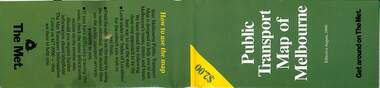
 Melbourne Tram Museum
Map, The Met, Public Transport Map of Melbourne - Get around on The Met, 8/1989
... maps ...Melbourne transport map - dated August 1989 - zone ticket system, has a photo of the front of B2 2004, includes a map of the ticket zones, and The Met contact details.Yields information about Melbourne public transport services in August 1989.Fold out map (36 sections 9 across x 4 deep), "Public Transport Map of Melbourne", coloured of Melbourne's Tram and Bus routes, route numbers, rail lines, detailed for the central part of Melbourne and the outer Metropolitan services.tramways, melbourne, tram services, bus services, railways, maps, zones -
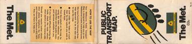
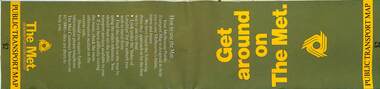 Melbourne Tram Museum
Map, The Met, Public Transport Map - Get around on The Met, c1987
... maps ...Undated map - c1987 - Neighbourhood and travelcard tickets, has a photo of the front of B2 2004, includes a map of the travelcard neighbourhoods, commuter passes and The Met contact details.Yields information about Melbourne public transport services in c1987Fold out map (36 sections 9 across x 4 deep), "Public Transport Map", coloured of Melbourne's Tram and Bus routes, route numbers, rail lines, detailed for the central part of Melbourne and the outer Metropolitan services.tramways, melbourne, tram services, bus services, railways, maps, travelcard, neighbourhood tickets -
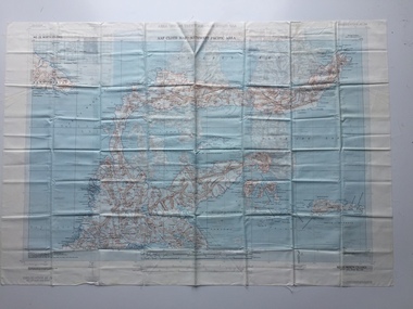 B-24 Liberator Memorial Restoration Australia Inc
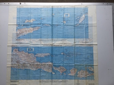
Map - US World War II multi-coloured map- Southwest Pacific Area, No. 23 North Celebes, No. 24 South Celebes, 1942-1943
Silk and rayon maps were produced by the United States (c. 7.5 million in total), Great Britain (some 1.75 million in total) and Australia during World War II. They were issued to Allied military personnel as part of 'escape and evasion' kits.This map, printed on acetate rayon, is an original US 'escape and evasion' kit map from World War II.A multi-coloured, contoured, double-sided map printed on acetate rayon AAF Cloth Map - Southwest Pacific Area Side 1 - No. 23 North Celebes Side 2 - No. 24 South Celebesworld war ii, silk maps, united states of america, a189 -
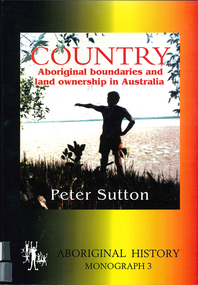 Victorian Aboriginal Corporation for Languages
Book, Peter Sutton, Country : Aboriginal boundaries and land ownership in Australia, 1995
Critique of Davis and Prescott Aboriginal frontiers and boundaries in Australia and map, Davis, S. Australias extant and imputed traditional Aboriginal territories; uses anthropological and linguistic evidence to expose inaccuracies and lacunae in book and map; appended are comments on the Davis map by regional specialists.Maps, colour photographsindigenous land boundaries -
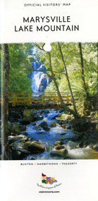 Marysville & District Historical Society
Map (Item) - Tourist map, Mystic Mountains Tourism, OFFICIAL VISITORS' MAP MARYSVILLE LAKE MOUNTAIN, Unknown
A visitors' map of Marysville and Lake Mountain produced by Mystic Mountains Tourism for Visit Victoria.A visitors' map of Marysville and Lake Mountain produced by Mystic Mountains Tourism for Visit Victoria.The Marysville and Lake Mountain Visitor Map and Touring Guide has been compiled and/ published by Mystic Mountains Tourism Inc. Copyright./ Production and artwork Graph Attack P/Lmarysville, lake mountain, victoria, australia, visitor's map, official visitors' map marysville lake mountain, buxton, narbethong, taggerty, visit victoria, mystic mountains tourism inc, graph attack p/l, mystic mountains, marysville triangle, marysville visitor information centre, marylands country house, black spur, steavenson falls, lady talbot drive, cambarville, cathedral ranges, wirreanda festival, lake mountain summit walk, summit walk loop, leadbeaters loop, day loop walk, buxton hotel, igloo roadhouse, karmann waters, silverstream b&b cottages, buxton trout and salmon farm, the niche wine bar, buxton post office & general store, choppers buxton roadhouse, woodlands rainforest bungalows, chestnut glade, black spur inn, wombat cottage, abbey lake luxury b&b spa cottages, mystic mountain ski hire & outdoors, pnl 4wdriving, blue views holiday units & ski hire, marapana agistment park & farm stay b&b, danico design, things of sand & stone, mantirri blueberry farm, allawah country cottages, amberview cottages, ashlar cottage b&b, black spur motel & caravan park, blackwood deluxe cottages, blackwood courtyard b&b, dalrymples guest cottages, delderfield, el kanah guest house, fruit salad farm, kerami guest house, keppels hotel, lake mountain-snow gum lodge, lomatia lodge, lyell guest cottages, magnolia house, keppel waters, lyrebird apartments, marysville caravan park, all view spa apartments, riverside cottages, maryton park b&b country cottages, melina cottage, mountain lodge, mystic mountains holiday cottages, nanda binya lodge, rendezvous luxury cottages, scenic b&b motel, the cumberland, south cathedral farm, tower motel, willowbank at taggerty, woodlands rainforest retreat, marysville & district country club inc, mystic mountains ski hire & outdoors, rubicon valley horse riding, marysville trout and salmon ponds, gallipoli park, keppels lookout, cambarville-yarra ranges national park, lake mountain-yarra ranges national park, lady talbot drive-yarra ranges national park, cathedral range state park, steavenson river, taggerty river, acheron river, lake mountain alpine resort, bruno's art and sculpture garden, manical mechanicals, uncle fred & aunty val's old style lolly shop, carmyle farm boutique, crossways historic country inn, fraga's, gilberts restaurant, heights licensed bistro, the old woolshed cafe, cathedral view natural therapies, crystal journey -
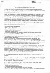 Greensborough Historical Society
Article - Cemeteries, David Weatherill, Donnybrook (Kalkallo) Cemetery, 10/09/1857o
A short history of the Donnybrook (Kalkallo) Cemetery by David W. Weatherill4 pages, text and maps.Hand drawn map of cemetery.donnybrook (kalkallo) cemetery -
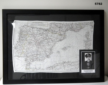 Bendigo Military Museum
Map - MAP, MEDITTERANEAN, SILK, C. 1939 - 45
... maps ...The silk maps were carried by Aircrew. Item in the collection re A.F. Goodall DFC RAAF, refer Cat No 543.2 for his service details.Framed black with black mounting background, silk map over in colour, scale 1: 3,000,000 showing the area of North Africa, Spain, France, Sardinia, the opposite side has mostly Southern France. Inset over is a photo of A.F. Goodall.maps, silk -
 Melbourne Tram Museum
Map, The Met, Public Transport Map of Melbourne - Get around on The Met, 12/1989
... maps ...Melbourne transport map - dated December 1989 - scratch ticket system, has a photo of the front of B2 2004, includes a map of the ticket zones, and The Met contact details.Yields information about Melbourne public transport services in December 1989 following the introduction of Scratch tickets.Fold out map (36 sections 9 across x 4 deep), "Public Transport Map of Melbourne", coloured of Melbourne's Tram and Bus routes, route numbers, rail lines, detailed for the central part of Melbourne and the outer Metropolitan services.tramways, melbourne, tram services, bus services, railways, maps, zones, scratch tickets -
 Whitehorse Historical Society Inc.
Map - WW1 German Field Map, Übersichtskarte fur die 2. Armee (Nordabschnitt), C 1915
... Maps ...Paper printed map of German Field positionsDetails area bounded by Mt. St. Quentin, Fresnoy, Riencourt, Canbrai and St AubertPaper printed map of German Field positionsmaps, world war 1914 - 1918, honybun charles -
 Greensborough Historical Society
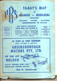
Map, To-day's Map of Ivanhoe - Heidelberg; including Rosanna, McLeod, Watsonia, Greensborough to Eltham, 1937-1953
... maps ...Map of the suburbs of Ivanhoe, Heidelberg, Rosanna, Macleod, Watsonia, Greensborough and Eltham. Dates to mid 1950s. An Advertiser on this map may be found in the Hurstbridge Advertiser Friday 17 December 1937, page 7: "Lyon Bros, of Eltham garage, suggest in their advertisement on the front page of this issue. that motorists should have their cars checked over by them before Christmas, so that any 5mall defects which might militate against the pleasure of the trip, might be remedied." As does "The Montsalvat Plant Farm" in The Age of Saturday 5 September 1953, page 48.Shows early streets and open space in these areas.Fold out map in pale blue cover. Cover dimensions: 21.5x15cm. Map is surrounded by advertising for local businesses.ivanhoe, maps, heidelberg, rosanna, macleod, watsonia, greensborough, eltham -
 B-24 Liberator Memorial Restoration Australia Inc
Map - US World War II-coloured map, - Southwest Pacific Area, No.22 Southwestern, No.26 East Java, No.25 Timor, 1943
Silk and rayon maps were produced by the United States (c. 7.5 million in total), Great Britain (some 1.75 million in total) and Australia during World War II. They were issued to Allied military personnel as part of 'escape and evasion' kits.This map, printed on acetate rayon, is an original US 'escape and evasion' kit map from World War II.A multi-coloured, contoured, double-sided map printed on acetate rayon AAF Cloth Map - Southwest Pacific Area Side 1 - No. 22 Southwestern and No. 26 East Java Side 2 - No. 25 Timorworld war ii, silk maps, united states of america, a188 -
 Melbourne Tram Museum
Map, Public Transport Corporation (PTC), "Public Transport Map of Melbourne", 5/1995
... maps ...Map Includes description of tram and bus routes, private bus routes, and rail lines. Has contact details for bookings and lost property etc and how to use the map. Gives details of the ticketing system, along with photographs of the various modes. Dated May 1995 with a stylised image of some of Melbourne's landmarks on the cover. Published by the Public Transport Corporation.Yields information about Melbourne public transport services in 1995.Fold out map (36 sections 9 across x 4 deep), "Public Transport Map", coloured of Melbourne's Tram and Bus routes, route numbers, rail lines, detailed for the central part of Melbourne and the outer Metropolitan services.tramways, melbourne, tram services, bus services, maps, railways -
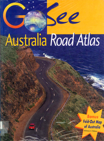 Victorian Aboriginal Corporation for Languages
Book, Valerie Marlborough, Go see Australia road atlas, 2000
Contains state by state maps and details about each state.Maps, colour photographsatlases, road maps, australian travel