Showing 1095 items
matching marie-louise
-
 Lakes Entrance Regional Historical Society (operating as Lakes Entrance History Centre & Museum)
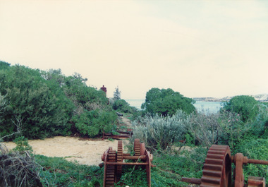
Photograph, Fish, Marie, 2000c
Also three views of old machinery.Colour photograph showing rusted remains of the travelling crane at the entrance Lakes Entrance Victoriahouses, islands, waterways, ships and shipping -
 Lakes Entrance Regional Historical Society (operating as Lakes Entrance History Centre & Museum)
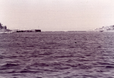
Photograph, Fish, Marie, 1995c
Black and white photograph showing view of entrance with eastern and western concrete and rock piers. Photo taken from boat in the channel. Waves breaking on bar at the entrance, at Lakes Entrance, Victoriaon back - The Entrance - taken from works boat, 1995jetties, topography, waterways -
 Lakes Entrance Regional Historical Society (operating as Lakes Entrance History Centre & Museum)
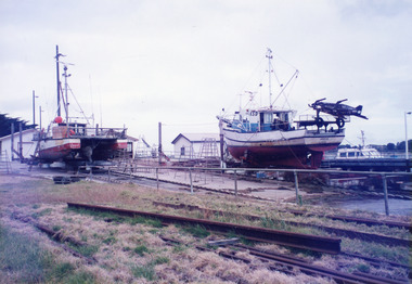
Photograph, Fish Marie, 2000
Blue Eye' owned by Horst FischerColour photograph of the catamaran Blue Eye on the slips with the scallop fishing boat the Windrode on the right, at Eastern wharf slipway, Lakes Entrance, Victoria.fishing industry, shipwrecks, ships and shipping, coast -
 Lakes Entrance Regional Historical Society (operating as Lakes Entrance History Centre & Museum)
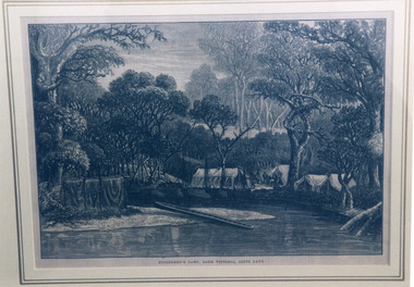
Photograph, Fish, Marie, 1999 c
Photographed from a book illustrationPhotograph of a woodcut depicting an early camp of fishermen on Lake Victoria, Gippsland Lakes, Victoria.Fishermen's Camp, Lake Victoria, Gipps Landvegetation, camping -
 Lakes Entrance Regional Historical Society (operating as Lakes Entrance History Centre & Museum)
Photograph, Fish Marie, 1985c
Colour photograph of township, showing building on Bullock Island, Cunningham Arm and small white shed on old New Works Jetty near the entrance, view towards the barrier. Photo taken from near telecom tower on Merrangbaur Hill 1985c. Lakes Entrance Victoriatopography, township, waterways, bridges -
 Lakes Entrance Regional Historical Society (operating as Lakes Entrance History Centre & Museum)
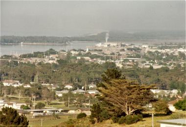
Photograph, Fish, Marie, 1985c
Colour photograph of township, showing buildings, Jemmys Point, Mount Barkly, Kalimna Heights, North Arm and old North Arm bridge, and Rigby Island beyond. Sea Vista flats in foreground. Photo taken from near Telecom Tower on Merrangbaur Hill. Lakes Entrance Victoriatopography, township, waterways, bridges -
 Lakes Entrance Regional Historical Society (operating as Lakes Entrance History Centre & Museum)
Photograph, Fish, Marie, 1985c
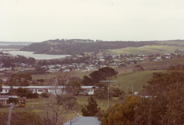
Colour photograph of part of township showing Jemmys Point, Mount Barkly, Kalimna Heights, North Arm & old North Arm bridge, looking beyond to Rigby Island. Photo taken from near Telecom Tower on Merrangbaur Hill. Lakes Entrance Victoriatopography, township, waterways, bridges -
 Lakes Entrance Regional Historical Society (operating as Lakes Entrance History Centre & Museum)
Photograph, Fish, Marie, 1985c
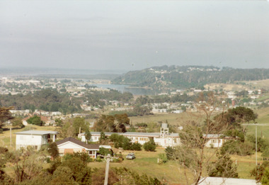
Colour photograph, image of part of township, showing Jemmys Point, Mount Barkly, North Arm and old North Arm bridge, football ground mid picture. View towards Rigby Island, Hopetoun Channel and dunes. Photo taken using telephoto lenses from near Telecom Tower on Merrangbaur Hill. Lakes Entrance Victoriaconstruction, bridges, waterways -
 Lakes Entrance Regional Historical Society (operating as Lakes Entrance History Centre & Museum)
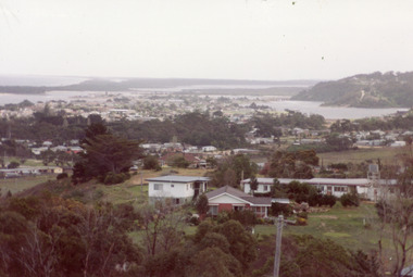
Photograph, Fish, Marie, 1985c
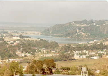
\Colour photograph of township showing, North Arm and North Arm Bridge, Jemmys Point, Mount Barkly, Kalimna Heights on right, Cunninghame Arm and sand dunes on left. Looking towards Bullock Island and Rigby Island and Hopetoun Channel in centre background. Sea Vista flats in foreground. Photo take from near Telecom Tower on Merrangbaur Hill circa 1985. Lakes Entrance Victoriaconstruction, bridges, waterways -
 Lakes Entrance Regional Historical Society (operating as Lakes Entrance History Centre & Museum)
Photograph, Fish, Marie, 1985c
Colour photograph of township showing, North Arm and North Arm Bridge, Jemmys Point, Mount Barkly, Kalimna Heights on right, Cunninghame Arm and sand dunes on left. Looking towards Bullock Island and Rigby Island and Hopetoun Channel in centre background. Sea Vista flats in foreground. Photo take from near Telecom Tower on Merrangbaur Hill circa 1985. Lakes Entrance Victoriaconstruction, bridges, waterways -
 Lakes Entrance Regional Historical Society (operating as Lakes Entrance History Centre & Museum)
Photograph, Fish, Marie, 1990c
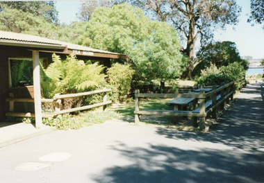
Colour photograph of the kiosk on the sand hummocks. It shows a corner of the kiosk, the rustic garden, picnic tables and seats. Pathway to footbridge and glimpse of Cunninghame Arm in distance. Lakes Entrance Victoriarestaurant, recreation, room display -
 Lakes Entrance Regional Historical Society (operating as Lakes Entrance History Centre & Museum)
Photograph, Fish Marie, 1990c
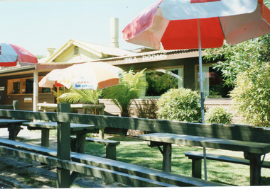
Colour photograph of the kiosk on the hummocks. It shows the kiosk with enlarged dining room, garden with rustic picnic tables and seats and three open colored sun umbrellas. Lakes Entrance Victoriatopography, waterfront, township, boats and boating -
 Lakes Entrance Regional Historical Society (operating as Lakes Entrance History Centre & Museum)
Photograph, Fish Marie, 1995c
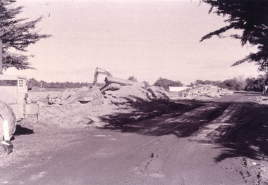
Black and white photograph, heavy machinery clearing the site of Pecks fish processing factory on Bullock Island, showing piles of broken concrete ready for removal. Lakes Entrance Victoriaislands, waterways, topography -
 Lakes Entrance Regional Historical Society (operating as Lakes Entrance History Centre & Museum)
Photograph, Fish Marie, 2005c
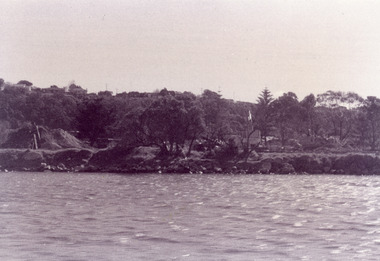
Black and white photograph showing heavy machinery clearing the site of Pecks fish processing factory on Bullock Island, photo also shows dumped sand on island and Kalimna Heights in background. Lakes Entrance Victoriaislands, waterways, topography -
 Lakes Entrance Regional Historical Society (operating as Lakes Entrance History Centre & Museum)
Photograph, Fish Marie, 1995
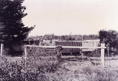
Black and white photograph of the site of Peck's fish processing factory on Bullock Island. It shows a heavy machine in background, broken concrete and rubbish skip in foreground, site cleared for TAFE education complex. Lakes Entrance Victoriaislands, waterways, dredging, topography -
 Lakes Entrance Regional Historical Society (operating as Lakes Entrance History Centre & Museum)
Photograph, Fish Marie, 1995
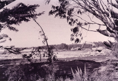
Also another black and white photograph of cleared site of Pecks factory 01611.1Black and white photograph of Bullock Island. It shows the site of Pecks fishing processing factory being cleared, Kalimna Heights in background taken from New Works area of southern shore of Cunninghame Arm. Lakes Entrance Victoriaislands, dredging, transport, machinery -
 Lakes Entrance Regional Historical Society (operating as Lakes Entrance History Centre & Museum)
Photograph, Fish Marie, 1995
Black and white photograph of Bullock Island. It shows the site of Peck's fish processing factory being cleared. Cunninghame Arm of lake in foreground, Kalimna Heights escarpment in background. Lakes Entrance Victoriaislands, dredging, machinery -
 Lakes Entrance Regional Historical Society (operating as Lakes Entrance History Centre & Museum)
Photograph, Fish Marie, 1995
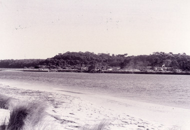
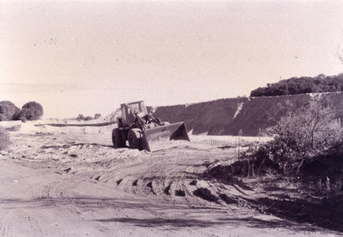
Black and white photograph of a bulldozer with a bucket scoop shifting sand on Bullock Island. This sand was dumped during dredging operations at the entrance and around the lakes. Lakes Entrance Victoriaislands, education, waterways, navigation -
 Lakes Entrance Regional Historical Society (operating as Lakes Entrance History Centre & Museum)
Photograph, Fish Marie, 1965
Also one other photograph, similar viewColour photograph of the first road bridge from Lakes Entrance to Bullock island, which was built for Public Works Dept. groyne building and sand build up to enlarge the island. Built early 1953. Lakes Entrance Victoriawaterways, topography, transport, room display -
 Lakes Entrance Regional Historical Society (operating as Lakes Entrance History Centre & Museum)
Photograph, Fish Marie, 1980
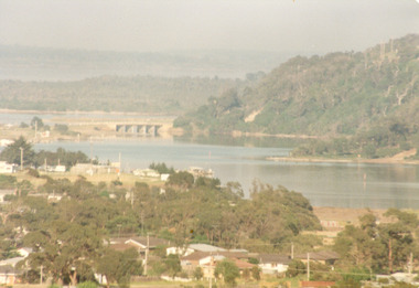
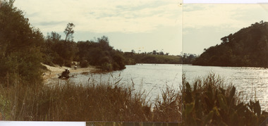
Two photographs stitched together to show a panoramic view.Colour photograph showing view of Lake Bunga, near Lakes Entrance, looking upstream from near the entrance. Tramway bridge almost gone. Some piles remain. Vegetation on sides of lake, background hill cleared, seats along the shoreline, lake full and clean. Lake Bunga Victoriabridges, waterways -
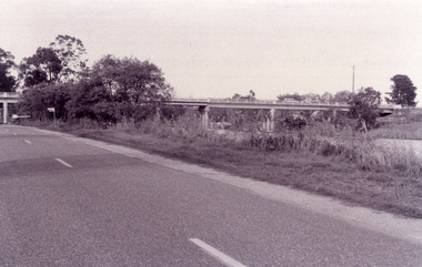
 Lakes Entrance Regional Historical Society (operating as Lakes Entrance History Centre & Museum)
Photograph, Fish Marie, 1965
Also scanned photograph of a vehicle crossing the original bridgeBlack and white photograph showing the old Burnt Bridge over Toorloo Arm before being closed to vehicular traffic, near Lakes Entrance, Victoria,bridges, waterways -
 Lakes Entrance Regional Historical Society (operating as Lakes Entrance History Centre & Museum)
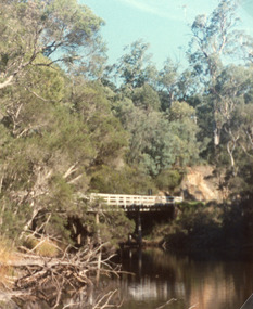
Photograph, Fish Marie, 1980
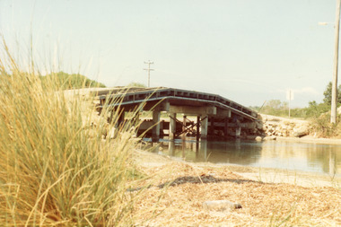
Second photograph 10 x 12 cm, taken before the bridge was demolished.Colour photograph showing the old highway bridge over Toorloo Arm near Lakes Entrance, dense forest surrounds. Toorloo Arm Victoria, .bridges, machinery, construction -
 Lakes Entrance Regional Historical Society (operating as Lakes Entrance History Centre & Museum)
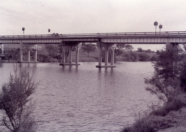
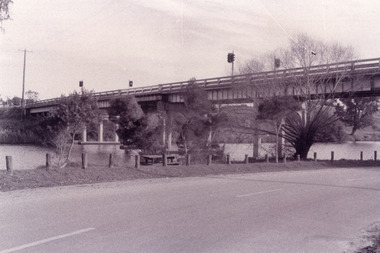
Photograph, Fish Marie, 1995
Black and white photograph showing view of the Swan Reach bridge over the Tambo River. Traffic lights on bridge to control traffic and reduce weight. Swan Reach Victoriabridges, waterways -
 Lakes Entrance Regional Historical Society (operating as Lakes Entrance History Centre & Museum)
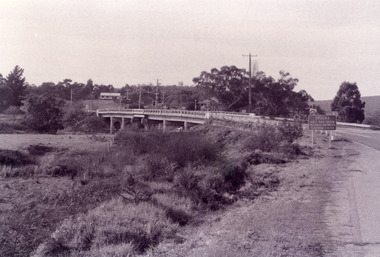
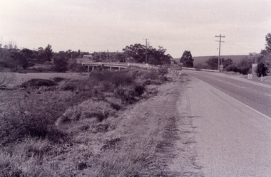
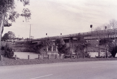
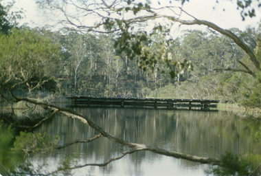
Photograph, Fish Marie, 1995
Colour photograph of the suspension bridge at Mississippi Creek picnic area in Colquhoun State Forest near Lakes Entrance, Victoriabridges, waterways, vegetation -
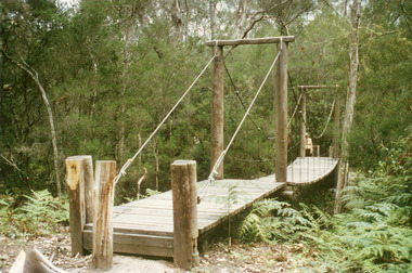
 Lakes Entrance Regional Historical Society (operating as Lakes Entrance History Centre & Museum)
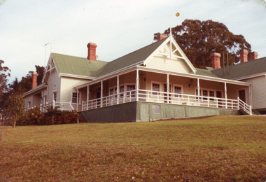
Photograph, Fish Marie, 1982
Also two other photographs of derelict farm buildings at Nyerimilang Park, Kalimna West, Victoria.Colour photograph of homestead taken at Nyerimilang Park soon after purchase by Victorian State Government. Kalimna West Victoriahouses