Showing 185202 items
matching melbourne-zoological-gardens
-
 Stawell Historical Society Inc
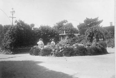
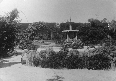
Photograph, Central Park Gardens
... Central Park Gardens ...Central Park Gardens with two ladies near fountain. Black & White Photograph in Central Park Gardens with two women standing near the fountain.stawell -
 Ballarat Heritage Services
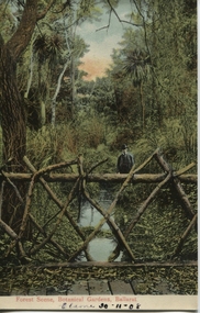
Postcard, Forest Scene, Botanical Gardens, Ballarat, 1908
... Forest Scene, Botanical Gardens, Ballarat ...In 1857 the Ballarat Police Horse Paddock was converted into a botanical garden near Yuilles Swamp (Lake Wendouree). George Longley was appointed the first curator living in a tent near where the Robert Clark Centre is today.postcardForest Scene, Botanical Gardens, Ballarat Elaine 30-11-08ballarat botanical gardens, ballarat police horse paddock, yuille's swamp, lake wendouree, george longley, robert clark centre. -
 Federation University Historical Collection
Photograph, Ballarat School of Mines Botanical Gardens
... Ballarat School of Mines Botanical Gardens ...The Ballarat School of Mines Botanical Garden was established in 1870, and was used by students of Materia Medica and Botany.(.1) Photograph of the Ballarat School of Mines Botanical Gardens showing stairs leading to a brick building (Administration Building). (.2) Photograph of the Ballarat School of Mines Botanical Gardens showing a bell shaped tree.ballarat school of mines botanical gardens, ballarat school of mines, materia medica, system garden -
 Tatura Irrigation & Wartime Camps Museum
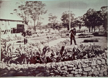
Photograph, Camp 13 gardens
... Camp 13 gardens ...Camp 13 gardens were attended to by the prisoners and did some beautiful workBlack and white photograph of the superb gardens of Camp 13 and 2 men gardening.camp 13, camp compounds, camp gardens -
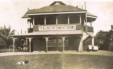 St Kilda Historical Society
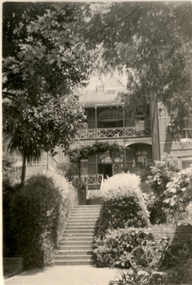
Photograph, Tea and Refreshment Rooms, Catani Gardens, c. 1927
... Tea and Refreshment Rooms, Catani Gardens ...Hand written on back: Catani Gardens 1927 From May Keeley Oakleigh HS 1985sepia original photograph fair conidtion unmountedTea and refreshment rooms. Catani Gardens 1927. From - May Keeley. Oakleigh H.S. 1985. -
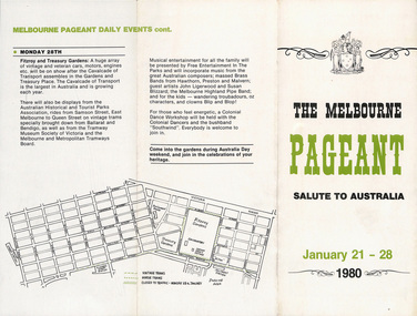 Melbourne Tram Museum
Pamphlet, Melbourne Pageant Committee, "The Melbourne Pageant - January 21 - 28 1980 - Salute to Australia, Cavalcade of Transport", 1980
Pamphlet - 3 fold DL - titled "The Melbourne Pageant - January 21 - 28 1980 - Salute to Australia, Cavalcade of Transport" advertising the planned events and dates with a map. Has name of Neil McPhee - chairman of Melbourne Pageant Committee Two copies held.trams, tramways, australia day, mmtb, melbourne, tramcars, pageant, melbourne pageant -
![Album (item) - Photographic Album, digital copy, Freda Kathleen Oxley (1882-1969), Album of photographs of a voyage to Australia and visit to the Mission to Seamen, Melbourne [picture] / Freda Oxley, 1925-1928](/media/collectors/4f729f5897f83e0308601603/items/672c59ac552587060c889944/item-media/67a6dc3cd7095b7115fefda2/item-fit-380x285.jpg) Mission to Seafarers Victoria
Mission to Seafarers VictoriaAlbum (item) - Photographic Album, digital copy, Freda Kathleen Oxley (1882-1969), Album of photographs of a voyage to Australia and visit to the Mission to Seamen, Melbourne [picture] / Freda Oxley, 1925-1928
... gardens ...This is a copy of an album of photographs held at the National Library of Australia. The album was photographed by Reverend's Weller grand daughter. Freda Oxley was a friend of the Wellers. She was born in Windsor in 1882 and Alexina Weller (nee Caley) was born in 1885 also in Windsor. She travelled on the SS Persic from England and arrived in 1925. She stayed at the Mission for several years, and became a host of the many picnics, making friends with the ladies from the Guild, taking photographs of people and events. Page 1 to 3: Outward Bound - SS Persic - September 26th .... November 12th 1925 Page 4: Interiors of the Mission to Seamen Melbourne Page 5: Page 6: Page 7: Page 8: Freda Oxley, the Wellers, Alexina Weller, Xmas Day 1927, Dora Walker and Rev. Weller Page 9: Gardens: the photographs show the garden's plants in its early years / Botanical Gardens / Nellie Melba's gardens in her estate Coombe: Walter Butler, the architect of the Mission had designed some extensions for Nellie Melba's estate and part of the gardens of the property, so it was likely through they acquaintance that the Mission's reverend and friends were invited. Page 10:This album provides photographs of the Mission's interiors, garden, staff, guests and activities during the Wellers stay. It also provides the provenance of the Weller album held in the Mission's collection.The album was donated to the National Library of Australia by Miss Elizabeth Phillips, with her address in England, with a typed note attached that reads: 'These photographs were taken by my aunt Miss Freda Oxley between 1925 and 1928. She went out to Melbourne at that time and stayed at the Mission to Seamen with her friends the Revd Jack Weller and Mrs Weller. The Revd Weller later became Bishop of the Falkland Islands.'freda kathleen oxley 1882-1969, ss persic, gardens, botanical garden, picnics, officers, portsea, sydney, rev. w.m robertson, dora simpson nee walker, wedding, alice sibthorpe tracy, ethel augusta godfrey 1861-1935, royal botanical garden, nellie melba, coombe, zoo, seamen, sailors, walter richmond butler (1864–1949), juan oyarzo, john oyarzo, fern tree gully, kerferd family -
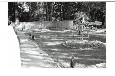 Buninyong & District Historical Society
Photograph - B/W photograph, Clive Brooks, Old Swimming Baths, Buninyong Botanic Gardens, 9 April 1994
... Old Swimming Baths, Buninyong Botanic Gardens ...Shows restoration of old swimming baths, and conversion to enclosed garden work completed.B/W photo of old Swimming Baths in Buninyong Botanic Gardens, constructed by Shire Engineer C P Wilson c 1919 around existing pool. Photo taken during refurbishment/conversion to walled garden. Old baths filled in, sunken lawn established, 2 round garden beds in place and planted, bluestone edging, two benches just visible..buninyong, swimming baths, botanic gardens, c p wilson -
 Kew Historical Society Inc
Plan, Melbourne & Metropolitan Board of Works : Contour Plan of Melbourne & Suburbs : Melbourne Sewage, 1894
The Melbourne and Metropolitan Board of Works (MMBW) plans were produced from the 1890s to the 1950s. They were crucial to the design and development of Melbourne's sewerage and drainage system. This plan forms part of a large group of MMBW plans and maps that was donated to the Society by the Mr Poulter, City Engineer of the City of Kew in 1989. Within this collection, thirty-five hand-coloured plans, backed with linen, are of statewide significance as they include annotations that provide details of construction materials used in buildings in the first decade of the 20th century as well as additional information about land ownership and usage. The copies in the Public Record Office Victoria and the State Library of Victoria are monochrome versions which do not denote building materials so that the maps in this collection are invaluable and unique tools for researchers and heritage consultants. A number of the plans are not held in the collection of the State Library of Victoria so they have the additional attribute of rarity.Digital copy of an original MMBW plan. This contour plan shows the area identified by the MMBW for purposes of drainage and sewerage in 1894. The suburbs represented extend from Williamstown in the west to Bulleen in the east, and from Preston in the north, south to Sandringham. Suburbs are outlined in coloured ink. Red lines indicate main and branch sewers in existence at the beginning of 1894 in central and inner Melbourne. These extended as far as Williamstown and Brighton, but not yet as far as Kew, where sewering did not commence until 1901. Contour lines show the topography, which was important for indicating the fall of the land for the laying of sewers and drainage channels. Kew appears to be fairly undeveloped at this date except for railway lines and stations (the Kew and Outer Circle lines), main roads, the Kew Lunatic Asylum Reserve and Studley Park. However, the contour plan does not accurately represent the density of settlement, nor the large number of houses, which were being built in Kew and other suburbs from the 1850s to the land boom of the late 1880’s and early 1890’s. This plan is part of a large and historically significant group of MMBW plans and maps that was donated to the Society by the Mr Poulter, City Engineer of the City of Kew in 1989.mmbw contour plan of melbourne and suburbs, melbourne and metropolitan board of works, melbourne sewage, cartography -
 Clunes Museum
Photograph, SEBASTOPOL GARDENS
... SEBASTOPOL GARDENS ...PART OF ORIGINAL DAM OF MR. HARRIS' MARKET GARDEN, SUTHERLAND STREET, CLUNES. OWNED BY HOLMANS PRIOR TO HARRIS..1 ORIGINAL MOUNTED SEPIA PHOTOGRAPH OF HARRIS MARKET GARDEN AND DAM - SEBASTOPOL GARDENS .2 COPY OF THIS IMAGE PRINTED FROM NEGATIVE ON PHOTO PAPER .3 POOR QUALITY COPY ON PHOTO PAPERPART OF ORIGINAL DAM - WAS HOLMAN'S PRIOR TO HARRISlocal history, photography, photographs, harris family -
 Federation University Historical Collection
Photograph - Colour Photograph, Ballarat School of Mines Botanical Gardens, 13/08/2020
... Ballarat School of Mines Botanical Gardens ...The Ballarat School of Mines Botanical Garden was established in 1870, and was used by students of Materia Medica and Botany.Photograph of the Ballarat School of Mines Botanical Gardens looking towards Albert Street. ballarat school of mines botanical gardens, ballarat school of mines, materia medica, system garden -
 Melbourne Tram Museum
Pamphlet, Melbourne Festival, "Melbourne Art Trams Oct 2014 - Apr 2015, 2014
Melbourne Art Trams On the rear is a photo of the SW5 731 Lesley Dumbrell Transporting Art Tram. Also notes that you can use TramTracker to find the Art Trams. James Cattell - 925 Janine Daddo - 3509 Kristin Headlam - 151 Jeff Makin - 252 Gabriella Possum Nungurrayi - 3008 Rone - 209 Christian Thompson - 259 Callum Croker - 158Demonstrates a Melbourne Art Trams Pamphlet for 2014-2015Pamphlet, folded sheet to give a DL size, pink background titled "Melbourne Art Trams" - Oct. 2014 to April 2015, vote for your favourite tram in the People's choice awards! - part of the Melbourne festival. Notes the Transporting Art trams. Inside the pamphlet are images of the artwork on 8 different trams including the artist names and title of the work if any. Has Melbourne Festival, Yarra Trams, PTV, Arts Victoria and Victorian Govt. logos.trams, tramways, yarra trams, transporting art, decorated trams, exhibitions, tram 731, tram 925, tram 3509, tram 151, tram 252, tram 3008, tram 209, tram 259, tram 158 -
 Stawell Historical Society Inc
Photograph, Central Park Gardens, c1910
... Central Park Gardens ...Photograph of Central Park Gardens showing rockery and fountain at center. c1910 Records state the copy was made from original loaned by Barry Griffin.Enlarged Black & White photo of Central Park Gardens showing water fountain surrounded by pathways, lawns and gardens. Duplicate photo also in Griffin Album on page 25, measurements given.stawell -
 University of Melbourne, Burnley Campus Archives
Album - Colour slides, Royal Botanic Gardens Plants, 1961-1963
... Royal Botanic Gardens Plants ...Approximately 40 slides, labelled, of plants at the Royal Botanic Gardens Melbourne. In compartmentalised wooden box. Not scannedroyal botanic gardens melbourne, plants -
 Buninyong & District Historical Society
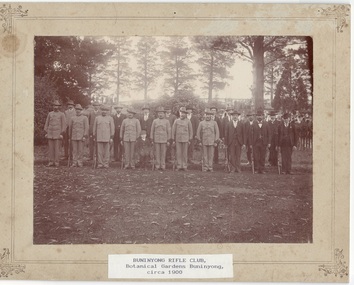
Photograph - Original B/W Photograph, J.T.Moyle, Buninyong Rifle Club, Botanical Gardens Buninyong, c.1900, c1901
... Buninyong Rifle Club, Botanical Gardens Buninyong, c.1900...Gardens ...historic, social, military, sportMounted Photograph of Buninyong Rifle Club, in Botanical Gardens Buninyong, c.1900.Notes on back; "Buninyong Rifle Club se Courier-8 May 1909 A.Sunter Possibly Buninyong Gardens Buninyong Rifle Club c 1903 Lippard in picture, also Walter Worland, Publican, Clarendon, 7th from left, front row (last one in uniform) Also Kenneth McLennan of Clarendon, David Prunty was also a member, Clarendon Rifle Club Clarendon Detachment, Buninyong Rifle Club, Buninyong Botanic Gardens, circa 1900 Photographer J.T. Moyle, Buninyongrifle club, buninyong, gardens, worland, lippard, mclennan -
 Emerald Museum & Nobelius Heritage Park
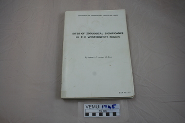
Book, Sites of Zoological Significance in the Westernport Region, 1984
... Sites of Zoological Significance in the Westernport Region ...Zoological Significance. The report contains the results of a survey of the vertebrate fauna of the Westernport catchment and a search of relevant literature, conducted between June 1979 and December 1981.White soft cover thick book, about A4 size. Prepared by the national Museum of Victoria for The Environmental Studies Division, Ministry of Conservation, Victoria 1984. -
Ringwood and District Historical Society
Document - Handout, Ringwood Garden Club, Handout of the Beautiful Gardens of Ringwood Competition, 19th and 20th September, 1987, 1987
... Handout of the Beautiful Gardens of Ringwood Competition ...Handout of the Beautiful Gardens of Ringwood Competition, 19th and 20th September, 1987.Foolscap typed sheet.BEAUTIFUL GARDENS OF RINGWOOD COMPETITION. 19th. & 20th. September, 1987. The following is a list of the Prize-Winning Gardens in this years Garden Competition. A total of 16 gardens were submitted for judging. Points awarded by the judge are in brackets and are given from a maximum of 100. Section 1: Home Garden - Street Frontage Exceeding 65 ft.(20 m.) 1st: Mr. B. Wheatley, 57 Oliver Street, Ringwood.(86) 2nd: Mr. K. Clark, 42 Bronhill Rd., Ringwood East.(67) 3rd: Mr. A. Blank, 28 Panorama Rd., Ringwood. (44) Section 2: Home Garden - Street Frontage Not Exceeding 65 ft. (20 m.) 1st. Mr. G. Williams, 69 Evelyn Rd., Ringwood.(73) 2nd. D. & P. Smithson, 7 Pamela Court, Nth. Ringwood. (72) 3rd. Mrs. D. Kane, 16 Lynwood Ave., Ringwood East.(65) Section 3: Home Garden - Front Only. Area that can be viewed from the Street. 1st: Mr. L. Sperling, 4 Lorienne Rd., Heathmont.(67) 2nd. Mr. H. Smit, 21 Unsworth Rd., Ringwood.(63) 3rd. Mr. & Mrs. G. Schmad, 8 Lyn Crt., Ringwood.(53) Section 4: Individual Garden in a Group of Flats or Home Units. (may include rear garden) 1st: Mr. & Mrs. C. & B. Harris, Unit 6, 32 Wilana St. Ringwood.(72) 2nd: Mr. & Mrs. W.C. & T. Wilson, Unit 5, 32 Wilana St., Ringwood. (49) Section 5: Garden in Non-Residential Property. There were no entries in this section. The Ringwood Garden Competition is sponsored by the Ringwood City Council and organised by the Ringwood Garden Club. The President and Committee of the Ringwood Garden Club would like to thank all home gardeners of Ringwood who entered this year's competition and hope they will enter again next year. If you would like to know more about the activities of our Club, come along to our meetings, which are held on the FOURTH MONDAY of each month, in the Ringwood Senior Citizens Clubrooms, Greenwood Ave., Ringwood commencing at 8.00 p.m. A warm welcome will be made to all visitors to our meetings. ____________________________________________ ___________________________________________ __________________________________________ _________________________________________ ________________________________________ -
 Federation University Historical Collection
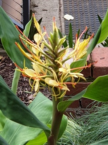
Photograph, Clare Gervasoni, Ginger in the Ballarat School of Mines Gardens, 23/04/2020
... Ginger in the Ballarat School of Mines Gardens ...The Ballarat School of Mines Botanical Gardens were established in 1879, and are situated at the rear of the current administration building. The gardens enabled the students to sit for examinations for registration by the Pharmacy Board of Victoria. An important aspect of this course was the study of Materia Medica, or botanical materials used for medicinal purposes.Colour photograph of ginger in the botanical garden sat the back of the Ballarat School of Mines Administration Building.smb botanical gardens, botanical gardens, smb, ballarat school of mines, school of mines ballarat, ballarat, photograph, ginger -
 Federation University Historical Collection
Photograph, Clare Gervasoni, Ginger in the Ballarat School of Mines Gardens, 26/03/2017
... Ginger in the Ballarat School of Mines Gardens ...The Ballarat School of Mines Botanical Gardens were established in 1879, and are situated at the rear of the current administration building. The gardens enabled the students to sit for examinations for registration by the Pharmacy Board of Victoria. An important aspect of this course was the study of Materia Medica, or botanical materials used for medicinal purposes.Colour photograph of ginger in the botanical garden sat the back of the Ballarat School of Mines Administration Building.smb botanical gardens, botanical gardens, smb, ballarat school of mines, school of mines ballarat, ballarat, photograph, ginger -
 Kew Historical Society Inc
Plan, Melbourne & Metropolitan Board of Works : Borough of Kew : Detail Plan No.1570, 1905
The Melbourne and Metropolitan Board of Works (MMBW) plans were produced from the 1890s to the 1950s. They were crucial to the design and development of Melbourne's sewerage and drainage system. The plans, at a scale of 40 feet to 1 inch (1:480), provide a detailed historical record of Melbourne streetscapes and environmental features. Each plan covers one or two street blocks (roughly six streets), showing details of buildings, including garden layouts and ownership boundaries, and features such as laneways, drains, bridges, parks, municipal boundaries and other prominent landmarks as they existed at the time each plan was produced. (Source: State Library of Victoria)This plan forms part of a large group of MMBW plans and maps that was donated to the Society by the Mr Poulter, City Engineer of the City of Kew in 1989. Within this collection, thirty-five hand-coloured plans, backed with linen, are of statewide significance as they include annotations that provide details of construction materials used in buildings in the first decade of the 20th century as well as additional information about land ownership and usage. The copies in the Public Record Office Victoria and the State Library of Victoria are monochrome versions which do not denote building materials so that the maps in this collection are invaluable and unique tools for researchers and heritage consultants. A number of the plans are not held in the collection of the State Library of Victoria so they have the additional attribute of rarity.Original survey plan, issued by the MMBW to a contractor with responsibility for constructing sewers in the area identified on the plan within the Borough of Kew. The plan was at some stage hand-coloured, possibly by the contractor, but more likely by officers working in the Engineering Department of the Borough and later Town, then City of Kew. The hand-coloured sections of buildings on the plan were used to denote masonry or brick constructions (pink), weatherboard constructions (yellow), and public buildings (grey). Plan No.1570 shows the layout of gardens and houses in Sackville Street, Davis Street, Wrixon Street, and Fitzwilliam Street in 1904. While Thomas Street is included on the map, at this stage no houses had been built. The plan identifies two named houses: ‘Fairview’ and ‘Kylemore’. Fairview is more fully delineated in Plan No.1563. Kylemore is one of the few houses in Kew designed by John Beswicke. The most notable owner of Kylemore was William Whitehead, who owned the house between 1895 and 1900. In 1894, Australian newspapers reported the marriage of Whitehead’s daughter to Dr. Gerald Eugene Cussen, the brother of Sir Leo Cussen, the Supreme Court Judge. The married couple was to live at ‘Wilton’ (now the Kew RSL) from 1911-15.melbourne and metropolitan board of works, detail plans, mmbw 1570, cartography -
 Melbourne Tram Museum
Pamphlet, Melbourne Festival, "Melbourne Art Trams Oct 2015 - Apr 2016, 2014
Melbourne Art Trams On the rear is a photo of the SW5 731 Lesley Dumbrell Transporting Art Tram. Also notes that you can use TramTracker to find the Art Trams. Amanda Morgan - 2009 Kathy Temin - 136 Martine Corompt - 270 Louise Forthun - 209 Matthew Bird - 3509 Phillip Adams - 3509 Tom Vincent - 925 Stephen Banham - 3008 James Voller - 175 Lesley Dumbrell - 731 Two copies heldYields information about the 2015-2016 Melbourne Art TramsPamphlet, folded sheet to give a DL size, pink background titled "Melbourne Art Trams" - Oct. 2015 to April 2016, vote for your favourite tram in the People's choice awards! - part of the Melbourne festival. Notes the Transporting Art trams. Inside the pamphlet are images of the artwork on 8 different trams including the artist names and title of the work if any. Has Melbourne Festival, Yarra Trams, PTV, Arts Victoria and Victorian Govt. logos.trams, tramways, yarra trams, transporting art, decorated trams, exhibitions, tram 731, tram 925, tram 3509, tram 151, tram 252, tram 3008, tram 209, tram 259, tram 158 -
Hume City Civic Collection
Photograph, Rupertswood Gardens
... Rupertswood Gardens...Gardens ...The gardens in the photograph are in the grounds at Rupertswood, the former summer residence of Sir William John and Lady Janet Clarke. Originally the gardens covered 99 acres and included a man-made lake in the shape of a map of Australia.A non-digital black and white photograph with a cream border of the lake and gardens in a spacious area with smaller buildings in the distanc.gardens, william sangster, sir william john clarke, lady janet clarke, trees, salesian college -
 Federation University Historical Collection
Photograph, Frank Wright, Two women seated in the Sturt Street Gardens, Ballarat, 16/10/1922
... Two women seated in the Sturt Street Gardens, Ballarat ...Frank Wright was a renown resident of Smeaton, where he was born. He lived at Laura Villa, and attended Smeaton State School. His father William was a gold miner and his mother's name was Sarah. Their family won many singing and instrumental awards. Frank was tutored by Percy Code and became the Australian Open Cornet Champion by the age of eighteen. A year later, Frank conducted the City of Ballarat Band, and later the Ballarat Soldiers’ Memorial Band. He formed the Frank Wright Frisco Band and Frank Wright and his Coliseum Orchestra. These bands won many South Street awards, and Frank as conductor won many awards in the Australian Band Championship contest. In 1933 Frank Wright sailed to England to conduct the famous St Hilda’s Band and was later appointed Musical Director of the London County Council, where he organized many amazing concerts in parks, in and around the London district. He was made Professor of Brass and Military Band Scoring and conducted at the Guildhall of Music and Drama. Frank was often invited to adjudicate Brass Band Championships around Europe, in Australia, including South Street and in New Zealand. The Frank Wright Medal at the Royal South Street competition is awarded to an individual recognized as making an outstanding contribution to brass music in Australia.A black and white photograph of two women seated on a park bench. The women are Mrs Wright and her daughter Laura Wright. They are seated in the Sturt Street gardens. Ballarat Town Hall is in the background.Written in pen - Mrs Wright & Laura. Taken in Sturt St Gardens, Ballarat. 16/10/22, F.W.(au)frank wright, mrs wright, laura wright, ballarat, sturt st gardens, ballarat town hall -
University of Melbourne, Burnley Campus Archives
Document - Annual Report, 2021 Burnley Gardens Annual Report
... 2021 Burnley Gardens Annual Report ...management, grounds management, burnley gardens -
 Kew Historical Society Inc
Plan, Melbourne & Metropolitan Board of Works : Borough of Kew : Detail Plan No.1301, 1910
The Melbourne and Metropolitan Board of Works (MMBW) plans were produced from the 1890s to the 1950s. They were crucial to the design and development of Melbourne's sewerage and drainage system. The plans, at a scale of 40 feet to 1 inch (1:480), provide a detailed historical record of Melbourne streetscapes and environmental features. Each plan covers one or two street blocks (roughly six streets), showing details of buildings, including garden layouts and ownership boundaries, and features such as laneways, drains, bridges, parks, municipal boundaries and other prominent landmarks as they existed at the time each plan was produced. (Source: State Library of Victoria)This plan forms part of a large group of MMBW plans and maps that was donated to the Society by the Mr Poulter, City Engineer of the City of Kew in 1989. Within this collection, thirty-five hand-coloured plans, backed with linen, are of statewide significance as they include annotations that provide details of construction materials used in buildings in the first decade of the 20th century as well as additional information about land ownership and usage. The copies in the Public Record Office Victoria and the State Library of Victoria are monochrome versions which do not denote building materials so that the maps in this collection are invaluable and unique tools for researchers and heritage consultants. A number of the plans are not held in the collection of the State Library of Victoria so they have the additional attribute of rarity.Original survey plan, issued by the MMBW to a contractor with responsibility for constructing sewers in the area identified on the plan within the Borough of Kew. The plan was at some stage hand-coloured, possibly by the contractor, but more likely by officers working in the Engineering Department of the Borough and later Town, then City of Kew. The hand-coloured sections of buildings on the plan were used to denote masonry or brick constructions (pink), weatherboard constructions (yellow), and public buildings (grey). Throughout its history, the land in what is known today as Studley Ward of the City of Boroondara has been subject to continuing subdivision. This is evident in Plan 1301, where later hands have modified the original map to include streets created subsequent to the printing of the plan in 1904. Other annotations such as the ‘Reserved for Road Purposes’ beside the Yarra never eventuated. The plan continued to be modified to at least 1953, when a later hand noted that a particular site was ‘Property site P. McIntyre house’ in Swinton Avenue. Two significant houses in the area are outlined on the plan: ‘Swinton’ on the corner of the streets then named Effey and Maud Streets (now Swinton Avenue) and ‘Fairhaven’ [unnamed] in Stevenson Street. The gardens of the two David Syme owned mansions of ‘Blythswood’ and ‘Rockingham’, stretching down to the River Yarra, are also represented.melbourne and metropolitan board of works, detail plans, mmbw 1301, cartography -
Federation University Historical Collection
Book, University of Melbourne Matriculation and Junior Commercial Examinations, 1905, 12/1905
University of Melbourne Archives, ref No: 1979.0018, University of Melbourne, Public Examinations Branch, 137 Volumes, Matriculation Examination entries 1855-1903, results and returns 1856-1905, Historical Note describing Matriculation Principal Dates for 1905 from Melbourne University including matriculation.Brown buff paperback book, 106 pages, fold out typewriting exam on page 60. Examinations include Greek, Geometry, Algebra, English, History, French, Grammar, German, Arithmetic, Geography, Chemistry, Physics, Botany, Drawing, Commercial, Bookkeeping, Music, Latin, Physics.university of melbourne, matriculation, examination -
 Broadmeadows Historical Society & Museum
Photograph, Meeting at the Community Centre; Banksia Gardens 1998, 3 February 2025
... Meeting at the Community Centre; Banksia Gardens 1998 ...This black and white photograph from 1998 shows students greeting each other outside the Banksia Gardens Community Centre. The image highlights the Centre's role in fostering community connections and support, pivotal in transforming the estate through educational and social programs.This black and white photograph from 1998, depicting students greeting each other outside the Banksia Gardens Community Centre, highlights the Centre's crucial role in fostering community connections and support. The image symbolises the Centre's impact in transforming the estate through educational and social programs, enhancing community resilience and cohesion.Black and white photograph on glossy photographic paper.Students greet each other outside/Banksia Gardens Community Centre 1998banksia gardens, broadmeadows, community centre, 1998 -
 Kew Historical Society Inc
Plan, Melbourne & Metropolitan Board of Works : Borough of Kew : Detail Plan No.1576, 1904
The Melbourne and Metropolitan Board of Works (MMBW) plans were produced from the 1890s to the 1950s. They were crucial to the design and development of Melbourne's sewerage and drainage system. The plans, at a scale of 40 feet to 1 inch (1:480), provide a detailed historical record of Melbourne streetscapes and environmental features. Each plan covers one or two street blocks (roughly six streets), showing details of buildings, including garden layouts and ownership boundaries, and features such as laneways, drains, bridges, parks, municipal boundaries and other prominent landmarks as they existed at the time each plan was produced. (Source: State Library of Victoria)This plan forms part of a large group of MMBW plans and maps that was donated to the Society by the Mr Poulter, City Engineer of the City of Kew in 1989. Within this collection, thirty-five hand-coloured plans, backed with linen, are of statewide significance as they include annotations that provide details of construction materials used in buildings in the first decade of the 20th century as well as additional information about land ownership and usage. The copies in the Public Record Office Victoria and the State Library of Victoria are monochrome versions which do not denote building materials so that the maps in this collection are invaluable and unique tools for researchers and heritage consultants. A number of the plans are not held in the collection of the State Library of Victoria so they have the additional attribute of rarity.Original survey plan, issued by the MMBW to a contractor with responsibility for constructing sewers in the area identified on the plan within the Borough of Kew. The plan was at some stage hand-coloured, possibly by the contractor, but more likely by officers working in the Engineering Department of the Borough and later Town, then City of Kew. The hand-coloured sections of buildings on the plan were used to denote masonry or brick constructions (pink), weatherboard constructions (yellow), and public buildings (grey). Development in the 20th century has irreparably altered that part of Kew represented in this plan. In the block bounded by Cotham Road, Charles Street, Wellington Street and Gellibrand; just one house standing in 1903 remains. This block included two of the most historic houses in Kew: ‘Ordsall’ (later ‘Southesk’) and ‘Madford’ (previously ‘Elm Lodge’). Ordsall was the home of the second chairman of Kew, John Halfey. It contained some of the most significant interior murals in Kew, created for Halfey by artists working for Cullen & Co. It was demolished in 1960 to make way for the Kew Civic Centre. Elm Lodge had been built for William Siddeley in ca. 1864. Arthur Septimus King purchased it in 1874. The lower paddocks of Madford were sold in 1905 by his wife to the Borough of Kew and, after landscaping by George and Thomas Pockett, opened as the Alexandra Gardens in 1908. Elm Lodge/Madford was in 1922 to become St. Anthony’s Home for Little Children before its subsequent demolition in the 1980s.melbourne and metropolitan board of works, detail plans, maps - borough of kew, mmbw 1576, cartography -
 Kew Historical Society Inc
Plan, Melbourne & Metropolitan Board of Works : Borough of Kew : Detail Plan No.1581, 1904
The Melbourne and Metropolitan Board of Works (MMBW) plans were produced from the 1890s to the 1950s. They were crucial to the design and development of Melbourne's sewerage and drainage system. The plans, at a scale of 40 feet to 1 inch (1:480), provide a detailed historical record of Melbourne streetscapes and environmental features. Each plan covers one or two street blocks (roughly six streets), showing details of buildings, including garden layouts and ownership boundaries, and features such as laneways, drains, bridges, parks, municipal boundaries and other prominent landmarks as they existed at the time each plan was produced. (Source: State Library of Victoria)This plan forms part of a large group of MMBW plans and maps that was donated to the Society by the Mr Poulter, City Engineer of the City of Kew in 1989. Within this collection, thirty-five hand-coloured plans, backed with linen, are of statewide significance as they include annotations that provide details of construction materials used in buildings in the first decade of the 20th century as well as additional information about land ownership and usage. The copies in the Public Record Office Victoria and the State Library of Victoria are monochrome versions which do not denote building materials so that the maps in this collection are invaluable and unique tools for researchers and heritage consultants. A number of the plans are not held in the collection of the State Library of Victoria so they have the additional attribute of rarity.Original survey plan, issued by the MMBW to a contractor with responsibility for constructing sewers in the area identified on the plan within the Borough of Kew. The plan was at some stage hand-coloured, possibly by the contractor, but more likely by officers working in the Engineering Department of the Borough and later Town, then City of Kew. The hand-coloured sections of buildings on the plan were used to denote masonry or brick constructions (pink), weatherboard constructions (yellow), and public buildings (grey). The streets and built structures in this plan were surveyed in 1903 and released to contractors in 1904. In addition to the designation of building types by colour, the plan includes detailed descriptions of land use and ownership. While many buildings remain from this period, a number of the buildings represented have been demolished including the original Kew Town Hall, and the Congregational and Roman Catholic churches in Walpole Street. While the mansion ‘Illapa’ in Princess Street is still extant – now part of ‘Rylands’ – the neighbouring mansion ‘Elsmere’ was demolished some decades ago. Rivalling Illapa and Elsmere in size were two mansions in Walpole Street, one named on the plan as ‘Gnarlbine’. Over time, Kew Junction and the south side of High Street have been reconfigured and widened, so that the commercial buildings on the corner of Princess and High Street no longer exist. A surprising feature of this part of central Kew to the northwest of Kew Junction is the amount of vacant land. In a number of cases, this land is noted by the contractor as used for vegetable gardens.melbourne and metropolitan board of works, detail plans, maps - borough of kew, mmbw 1581, cartography -
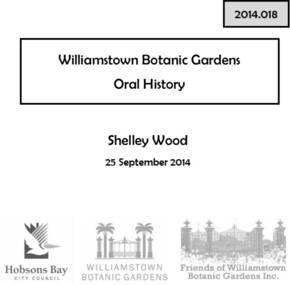 Williamstown Botanic Gardens- Hobsons Bay City Council
Oral History_Williamstown Botanic Gardens_Shelley Wood, 25/09/2014
... Williamstown Botanic Gardens ...The interview is one of a series recorded in 2013-2014 to document memories and experiences of the Williamstown Botanic GardensA primary source of information on memories of the Gardens and witness to changes in the Gardens over those years. CD and transcript of interview with Shelley Wood. Shelley was born in Williamstown, as was her mother Margaret McLean. Shelley recalls her mother telling her about spending many hours in the Gardens when she was young with her friend Chic, who was the daughter of the Curator Ernie Anderson. Shelley, who was the first female gardener appointed in the western region, served her apprenticeship at Gardens and is currently the Curator. shelley wood, margaret mclean, tom wood, chic anderson, ernie anderson, 1979, apprentice, fish pond, pinetum, barry heath, golden elm, palms, brian turner, dean splatt, robert anderson, 1988, bicentennial funding, 1987, angela altair, helen page, mary klestadt, mike hirst, john hawker, landscape advisory group, williamstown technical school, gates, buffalo lawn, ian brown, storytime, adam lindsay gordon, statue, archie matthews, aviary, williamstown botanic gardens, hobsons bay city council