Showing 531 items matching "mining history - victoria"
-
 Bendigo Historical Society Inc.
Map - MINE LOCATION DRAWING AT VICTORIA HILL
Claims and shafts location for: Rae and co. - Noye and co. - Wittscheibe. Some additions to drawing made in pencil.mining, business -
 Bendigo Historical Society Inc.
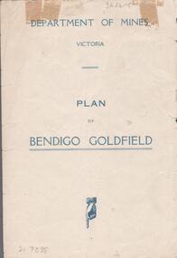
Map - BENDIGO GOLDFIELDS MAP
Map of the Bendigo Goldfield, showing reef lines, mines and significant geographical features such as Monument Hill, Quartz Hill and Diamond Hill. On the back of map 'Department of Mines, Victoria. Plan of Bendigo Goldfield.bendigo, mining, bendigo goldfields -
 Bendigo Historical Society Inc.
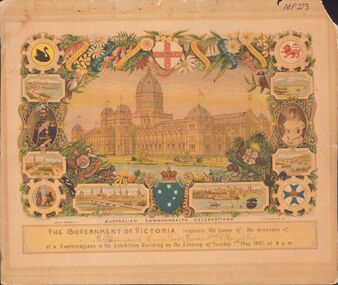
Document - INVITATION MR D.H FLEMING AND LADY - AUSTRALIAN COMMONWEALTH CELEBRATIONS, 1901, 07/05/1901
Invitation to The Chairman of the Mining Board, Bendigo Mr D H Fleming & Lady to a Conversazione in the Exhibition Building on Tuesday 7th May 1901. Invitation has native floral and animal decoration, scenes from Perth, Adelaide, Melbourne, Sydney, Brisbane and Hobart. It has the King And Queen at the centre sides and a swan in the top left corner, a lion in the top right, an aborigine and an explorer? In the bottom left, and a cross with a crown in the bottom right corner. At the centre top is a shield with a red cross with stars and a lion and at the bottom is a blue shield with the Southern Cross with a crown on the top. In the centre is a large picture of a building beside a lake. MP273 written at the top right corner. Rear of photo has impression of rubber stamp, royal Historical Society of Victoria, Bendigo Branch, 1959, 137 written in biro.document, invitations, official celebrations, invitation, australian commonwealth celebrations, mr d h fleming, government of victoria -
Bendigo Historical Society Inc.
Map - HUSTLER'S & CHRISTMAS LINES OF REEFS - PLAN OF LINES OF SECTION OF REEFS
Underground Survey of Mines Bendigo. Plan of Cross Section Lines Shewing Connections with Trigonometrical Stations and Base Lines. 13/3/99 Signed ? Stirling. Places and mines mentioned Speciman Hill, Tambour Major, Lansell's 180, Victory and Pandora, Great Extended Hustler's, Windmill Hill on Victoria Reef. Next part of map is a Plan of Lines of Section between the Hustler's and Christmas Lines of Reefs. 8/3/99. Signed ?. Transverse Section. Shows Tambour Major Co., near the Christmas Line of Reef, Crosscuts and their depth, geological features and stone encountered. Then shows Thistle Line, Charshalton Line, Napoleon Line, Nell Gwynne Line, New Chum Line, Lansell's No 180 with levels, depths and geological features. Drawing is continued in three parts to fit on paper. Lansell's East Shaft with levels and depths, geological features and stone encountered. Sheepshead Line, Old Shaft, Garden Gully Line, Victory and Pabndora Co with crosscuts, depths, geological features and stone encountered. Paddy's Gully Line, Derby Line, Millers Line, Hustler's Line, Great Extended Hustler's Co with levels, depths, geological features and stone encountered. A note beside a Saddle Reef: 360,000 pounds paid in dividends from this reef. Average ounces per ton gold noted where found. Reference Table for stone and geological features. Datum Line 700 feet above Sea Level Unscannedmining, parish map, hustler's & christmas lines of reefs, plan of lines of section of reefs, ? stirling, specimen hill, tambour major, lansell's 180, victory & pandora, great extended hustler's, windmill hill, victoria reef, tambour major co, christmas line, hustler's line, thistle line, carshalton line, napoleon line, nell gwynne line, new chum line, lansell's no 180, lansell's east shaft, sheepshead line, old shaft, garden gully line, paddy's gully line, derby line, miller's line, hustler's line, great extended hustler's co -
 Bendigo Historical Society Inc.
Document - REMINISCENCES OF MR JACK HATTAM: ORAL HISTORY ASSIGNMENT
Reminiscences of Mr Jack Hattam - 38 pp. Oral History assignment by Phyllis Smithson 1982. Introduction: ''This paper is a transcript of a taped interview with Mr Jack Hattam with annotations to augment his comments by Phyllis Smithson. Mr Hattam did not know a lot about his forebears so I have endeavoured to recreate some of the background and conditions his grandparents and relations would have encountered''. Bibliography and family tree.Jack Hattamperson, individual, jack hattam, st just point, long gully, voictorian quarts mining company, white hills cemetry, mr henry hattam mayor of bendigo, midway company, victoria reef, energetic ompany, bird's reef company, great eastern company, (sedgewick), hercules company, frank cusack, bendigo creek, bendigo valley, grub-staking, hopetoun street, john and ellen o'connell, hunters brewery. -
 Bendigo Historical Society Inc.
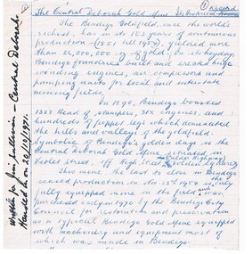
Document - CENTRAL DEBORAH GOLD MINE: HISTORY AND DESCRIPTION
2 typed copies of history and description of the Central Deborah Mine. Document describes the Historical Record, Historical Background, Brief Chronological History, Some Facts (a brief description of the machinery), Miners' Wages, Price of Gold, Huge Mining Machinery of Other Days, Some Notes on the Geology and the Central Deborah Reefs. Written by A. Richardson. One copy has 1235 D in a circle written on the top left corner and the second copy has Mr John Arthur 15/11/71 30c written across the top.mine, gold, central deborah mine, central deborah gold mine, history of central deborah gold mine, victoria hill, mining machinery, a. richardson, central deborah gold mine geology, central deborah gold mine reefs, price of gold -
 Bendigo Historical Society Inc.
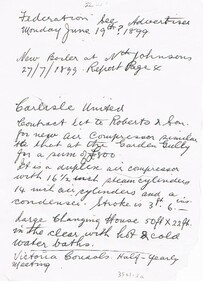
Document - CARLISLE UNITED MINE
Hand written notes about contract let to Roberts & Son for a new air compressor, dividends, Changing House and Half-Yearly meeting. Also notes referring to Federation, see Advertiser Monday June 19th? 1899, New Boiler at Nth Johnsons 27/7/1899, report page 4 and referring to Bendigonian Dec 28th 1899, report on dividends from Victoria Quartz Mine.place, mining site, carlisle united mine, carlisle united, roberts & son, air compressor, changing house, federation, advertiser monday june 19th? 1899, boiler, nth johnsons, victoria quartz mine, bendigonian dec 28th 1899 -
 Bendigo Historical Society Inc.
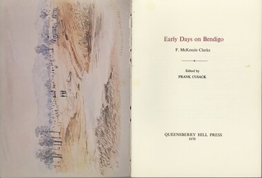
Book - VI CATTANACH COLLECTION: EARLY DAYS ON BENDIGO, 1979
Early days on Bendigo Author F.McKenzie Clarke Edited by Frank Cusack. The recollections of life on early Bendigo first appeared in the pages of the Bendigo Advertiser under the title 'The first discovery of gold at Bendigo' published by Queensberry Hill Press 86 pages. Cream colour soft cover.F. McKenzie Clarkbendigo, history, early recollections, gold mines & mining-victoria-bendigo district -
 Bendigo Historical Society Inc.
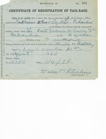
Document - MCCOLL, RANKIN AND STANISTREET COLLECTION: RENT RECEIPTS, 1930/40
1. Rent receipts, permissive occupancy, Monument Hill Consolidated. 2. Right to occupy a residence area, Victoria Phillipa Evans 127 Breen Street Bendigo. 3. Plan for applied Lease 10423. 5. Certificate of Registration of tail race. Loose documents.MCCOLL RANKIN & STANISTREETorganization, business, industrial - mining, mccoll rankin & stanistreet -
 Bendigo Historical Society Inc.
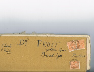
Document - MCCOLL, RANKIN AND STANISTREET COLLECTION: DR FROST, 1920
Correspondence to Dr. Frost re Badak Tin Mine. Binti Binti, Sweet Nell, Bettina, Mascotte & Maconi. Report on inspection of mine reports by Mr. M. Sheard (Mine Manager) & Dr. C. W. Laver of Kalgoorlie, map of Binti lease. Des Frost Golden Square Bendigo Victoria, charts and print.MCCOLL RANKIN & STANISTREETorganization, business, gold mining, mccoll rankin & stanistreet -
 Bendigo Historical Society Inc.
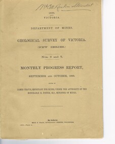
Document - MCCOLL, RANKIN AND STANISTREET COLLECTION: GEOLOGICAL SURVEY OF VICTORIA 1899, 1899
Booklet: 1899 Victoria Department of Mines Geological survey of Victoria (new series Nos. 6 &7. Monthly progress report, September, October issued by James Travis secretary for mines, under the Authority of the Hon. H. Foster M.P. Minister of Mines. McColl Rankin & Stanistreet, 1899 Victoria.MCCOLL RANKIN & STANISTREETorganization, business, industrial - mining, mccoll rankin & stanistreet -
 Bendigo Historical Society Inc.
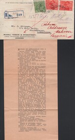
Document - MCCOLL, RANKIN AND STANISTREET COLLECTION: NORTH HUSTLERS, 1932
Envelope, and proof copy on paper advertisement. Addressed to J. Strange C/o Mrs. Berry, Storekeeper Langwarrin with one green 1 penny and two red, 2 penny stamps. It has a registered stamp no 519 from Bendigo Victoria. On the front hand written in red ink is "Return Addressee Unknown Langwarrin" and is initialled. On the back is four post mark stamps. Hand written on the front also is "North Hustlers"MCCOLL RANKIN & STANISTREETorganization, business, gold mining lease, mccoll rankin & stanistreet -
 Bendigo Historical Society Inc.
Document - CORRESPONDENCE: RE FREDERICK CLARK
Correspondence re Frederick Clark to BHS from Horace Clark 4/2/1976, grandson. Schoolteacher m. Ann Lampard, 1860. Request for family information. Reply from BHS - extract from 'Bendigo and Vicinity' re a Frederick Clark (''not the one you are researching''. In Bendigo and vicinity a Frederick Clark is written as born in Warwickshire in October 1834, left England after being taught the building trade, in 1856, and assisted in erection of old university buuildings in Carlton. Arrived in Bendigo in 1857, became interested in building batteries for quartz mining, travelling throughout Victoria and New Zealand with mining interests. Frederick entered the Eaglehawk council in 1870. Twice married his eldest son George was in the Education Department, His stepson Richard Hamilton - mining manager in Arizona U.S.A. The book Bendigo and Vicinity was printed in 1895, and this man is the only Clark mentioned.cottage, miners -
 Bendigo Historical Society Inc.
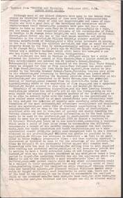
Document - CENTRAL DEBORAH GOLD MINE - HISTORY OF CENTRAL DEBORAH GOLD MINE
Typed carbon copy of the History of the Central Deborah Gold Mine from 1939 to 1954. Includes Chronological History, Machinery & Poppet Legs, the Reefs and the Method of Mining. Also a paragraph on the Victoria Hill site. There are a number of hand written inclusions on the pages.mine, gold, central deborah gold mine, central deborah gold mine, history of central deborah gold mine, mine machinery, victoria hill site -
 Bendigo Historical Society Inc.
Document - CENTRAL DEBORAH GOLD MINE - HISTORICAL RECORD
Hand written notes on the Historical Record of the Central Deborah Gold Mine written various size paper. It mentions the machinery, Miners' Wages, Price of Gold, Predictions of Victor Pabst, mining correspondent of the 'Bendigo Independent'.Other mining machinery. Written by A Richardson, dated 21/10/1971. Written in black pen - Written for Jim Sullivan - Central Deborah. Handed in on 20/10/1971.mine, gold, central deborah gold mine, central deborah gold mine, mining machinery, history of the central deborah gold mine, victor pabst, bendigo independent, the bendigo goldfield - resources of the central area, new monument battery, golden carshalton battery, north deborah, state battery, victoria hill, price of gold -
 Bendigo Historical Society Inc.
Document - INFORMATION: JOSEPH HENRY KNIGHT
Information re dentist Joseph Henry Knight (typewriten extract from 'Bendigo and Vicinity' 1895, p.79.person, individual, joseph henry knight, dentist, mitchelll street, mr william knight, pass by claim, mr joseph bell, st andrews school, miss howards, gravel hill state school, mr john slack, mr david watson, great extended victoria gold mining company, st andrews constitution, bendigo lodge, worshipful master, bendigo jocky club, ramblers club -
 Bendigo Historical Society Inc.
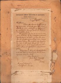
Document - AMALGAMATED MINERS' ASSOCIATION OF AUSTRALASIA, J.B. WATSON LETTER, 1891
Document: letter mounted ( stuck down ) on buff board. Letter head' Amalgamated Miners; Association of Australasia, Bendigo Branch No. 1, Beehive Chambers, July 17th., 1891.' Letter details thanks for raising money for J.B. Watson's 'sustentation fund' ( sustenance fund for miners )Amalgamated Miners Association of Victoriaorganization, mining, amalgamated miners' association, bendigo, mining, amalgamated miners' association of australasia, j.b. watson, sustentation (sic )fund, sustenance fund. -
 Bendigo Historical Society Inc.
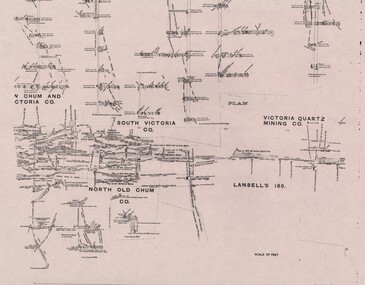
Negative - ALBERT RICHARDSON COLLECTION: TRANSPARENCIES OF MINE PLANS
Negatives: 9 transparencies ( or could be photocopies of overhead transparencies ) of mine plans in Bendigo. Enclosed in brown paper wrapper. Written on outside ' A ? Transparencies, A. Richardson' NOTE: Other items in Albert Richardson Collection in Box 130. a. Victoria Quartz Mining Co, South Victoria Col North Old Chum, Lansells 180, b. Gibbs, Ballerstedt, Humboldt Co and Wells, Great Central Victoria Co., Adventure and Advance Co., c. South Victori Co, Victoria Quartz Mining Co., Lansells 180 d. Longitudinal section - unmarked mine e. Gibbs, Ballerstedt Humboldt Co and Wells, Great Central Victoria Co., Adventure and Advance Co. f. South Victoria Co., Victoria Quartz Mining Co., Lansells 180 g. Longitudinal section, unmarked mine h. Gibbs, Ballerstedt, Humboldt Co, and Wells, Adventure and Advance Co. i Longitudinal section, unmarked mineLongitudiunanegative, bendigo, mine plans, bendigo, alf richardson, engineering, mining, mine plans. -
 Bendigo Historical Society Inc.
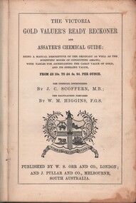
Book - MCCOLL, RANKIN AND STANISTREET COLLECTION: THE VICTORIA GOLD VALUERS READY RECKONER, 1853
Book; Cloth bound hard cover book - 'The Victoria Gold Valuer's Ready Reckoner and Assayers chemical guide'. Being a manual descriptive of the ordinary as well as the scientific modes of conducting assays; with tables for ascertaining the carat value of gold audits sterling value (Scoffern & Higgins) Spine missing. Inside front cover stamped Big Hill Mining Company.MCCOLL RANKIN & STANISTREETgold mining, miners' safety cage, gold valuers ready rreckoner, mccoll rankin & stanistreet -
 Bendigo Historical Society Inc.
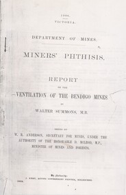
Document - HARRY BIGGS COLLECTION: REPORT ON VENTILATION OF BENDIGO MINES
Document: part of report on the ventilation of the Bendigo Mines. 1096 Victoria, Department of Mines, Miners' Phthisis.place, bendigo, historical items, bendigo, miners' phthisis, ventilation, mines, mining, disease -
 Bendigo Historical Society Inc.
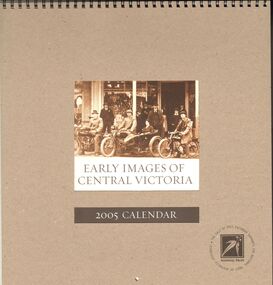
Document - EARLY IMAGES OF CENTRAL VICTORIA
1. National Trust 2005 calendar titled 'Early Images of Central Victoria' . 2. A4 sized Deidre Chesney correspondence to Jim Evans thanking him for inclusion of two BHS donated photographs. 3. Order Form. Calendar images in consecutive order 1. Bicycle Race Bendigo c1930. [BHS] 2. First Locomotive leaving Thompson's Foundry Castlemaine. 3. Portrait of Five Sisters. 4. Hanging Rock Races 1890. 5. Heath's Grocery Store. 6. Bendigo Women's Sewing Circle for the Boer War held in Fortuna Villa. 7. The Corner 'Ballarat first Mining Exchange'. 8. Clunes Children in Fancy Dress. 9. Walking Group ,Trentham Falls 1920. 10. Motorcyclists outside the Dunn & Allan store Ararat 1920. 12. Daylesford Lacrosse Team, 1910.bendigo, history, early images -
 Bendigo Historical Society Inc.
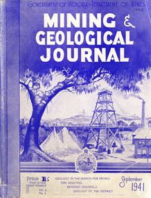
Book - MINING & GEOLOGICAL JOURNAL, September, 1941
Mining & Geological Journal September 1941, Geology in the search for metals, fire assaying, Bendigo goldfields, Geology of Yea district published half yearly by the Department of Mines Victoria contains photographs, maps and illustrations.gold, mining, journal -
 Bendigo Historical Society Inc.
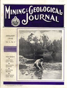
Book - MINING & GEOLOGICAL JOURNAL, 1940
Mining & Geological Journal January 1940 Vol.2 No.2 Mine reports Chewton Gold Field, Geological Glossary, Flotation Process, Wonthaggi Coal Field published hald yearly by he Department of Mines Victoria contains photographs, maps and illustrations.gold, mining, journal -
 Bendigo Historical Society Inc.
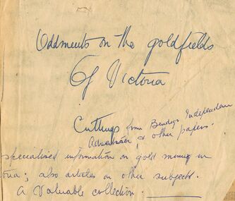
Book - GOLDFIELD NEWSPAPER CUTTINGS
Newspaper cuttings relating to gold mining predominantly from the Bendigo Advertiser, and to a lesser degree other Victorian newspapers. Dating commences 1904-7 and resumes early 1930-33. Cuttings have been pasted onto blank bound pages and protected within green cover of slightly smaller size. Covering handwritten note reads 'Oddments on the Goldfields of Victoria' ,'Cuttings from the Bendigo Advertiser, and other papers'. Specialised information on gold mining in Victoria ; also articles on other subjects, a valuable collection. No signature or donor.bendigo, gold mining, 1904-30 -
 Bendigo Historical Society Inc.
Document - ''MCIVOR GOLD ESCORT ROBBERY'': JOYCE COLES (TUTORIAL PAPER)
''McIvor Gold Escort Robbery'' - Joyce Coles (Australian History tutorial paper); no date. 14 pages handwritten paper to the July 1853 robbery - ''the first mass raid against armed gold escorts in Victoria''. Detailed account of the robbery and subsequent search for perpetrators and trial. Reference to possibility of gold still being buried in the area of the robbery. Bibliography, newspaper references and illustrations from a variety of specified sources.Joyce Colesbendigo, mining, early history., mcivor gold escort robbery, victoria, mt alexander, kyneton road -
 Bendigo Historical Society Inc.
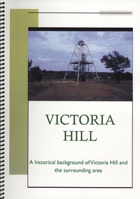
Book - VICTORIA HILL, A HISTORICAL BACKGROUND OF VICTORIA HILL AND THE SURROUNDING AREA, 2011
Victoria Hill a historical background of Victoria Hill and the surrounding area. Original article by Albert Richardson 1971 and revised and edited in 2012 by Philip Wilkin. Contains 26 pages with colour and black & white photographs and a map. Inside front cover is a 'Bendigo Miner' History Lives article by Jim Evans, dated 10 May 2012.Albert Richardson & Phillip Wilkinbendigo, mining, victoria hill -
 Bendigo Historical Society Inc.
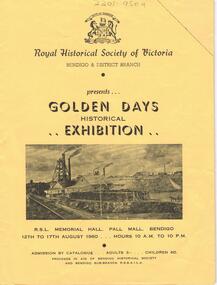
Document - LYDIA CHANCELLOR COLLECTION: ROYAL HISTORICAL SOCIETY OF VICTORIA
A yellow catalogue published by the Royal Historical Society of Victoria Bendigo & District Branch. It is presenting the ' Golden Days Historical Exhibition ' at the R.S.L. Memorial Hall, Pall Mall, Bendigo 12th to 17th August 1960. The categories of exhibits are antiques, bush ranging, coins and tokens, documents, fashions, firearms, geology, gold mining, pioneers, postal history, prints and photography, shipping and sport. Within the catalogue are Bendigo Advertiser July and August cuttings relating to the exhibition.history, australian, exhibition, lydia chancellor collection, collection, bendigo, australia, royal historical society of victoria, exhibits, bendigo city council -
 Bendigo Historical Society Inc.
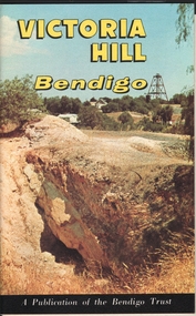
Book - JAMES LERK COLLECTION: VICTORIA HILL BENDIGO
14 pages booklet - Victoria Hill Bendigo - A publication of the Bendigo Trust.bendigo, mining, victoria hill -
 Bendigo Historical Society Inc.
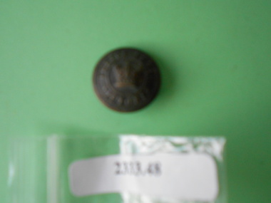
Clothing - QC BINKS COLLECTION:BUTTON
Metal button. A crown insignia is engraved in the centre and the words Police Force Victoria are engraved around the border. The words Wiseman Bros. Melbourne are engraved on the reverse. Item is rusted.Wiseman Bros. Melbournebendigo, gold mining, qc binks -
 Bendigo Historical Society Inc.
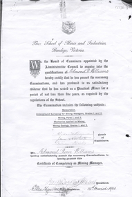
Document - ALMOND ROWE WILLIAMS COLLECTION: SCHOOL OF MINES AND INDUSTRY BENDIGO CERTIFICATE
Copy of certificate of competency as a Mining Manager, issued to Almond Rowe Williams by the School of Mines and Industries, Bendigo, Victoria, 18th March, 1901. 'Almond Rowe Williams has passed the necessary examinations and produced to us evidence that he has served as a Practical Miner for a period of not less than 5 years'bendigo, mining, almond rowe williams