Showing 384 items matching "mining plan"
-
 Bendigo Historical Society Inc.
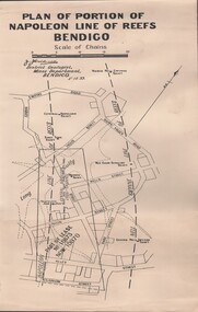
Document - MCCOLL, RANKIN AND STANISTREET COLLECTION: NAPOLEON REEF GOLD MINING CO. N.L, 5 December 1939
Document: 4 Copies of plans showing part of lease No. 10970 (was 10873) and Central Napoleon Lode Channel, prepared by J.J. Caldwell District Geologist, Mines Dept, Bendigo 5th Dec 1939.organization, business, industrial - mining, mccoll rankin & stanistreet, mining, gold mining, napoleon reef -
 Bendigo Historical Society Inc.
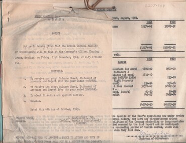
Document - MCCOLL, RANKIN AND STANISTREET COLLECTION: NORTH HUSTLERS GMC - CORRESPONDENCE FILE, 1940 - 1969
Document. Bundle of letters, etc bound together with string. Reports for Annual General Meetings including profit & loss statements. Lists of shareholders. Proxy forms. Application for renewal of lease for North Hustlers Mine 9.4.1950. Prospectus for Hustlers Reef. Plan of residential area for application of lease.McColl, Rankin & Stanistreetorganization, business, north hustlers gmc, mccoll, rankin & stanistreet, north hustlers gmc, gold mining, lease, share holders, profit & loss, prospectus, agm -
 Bendigo Historical Society Inc.
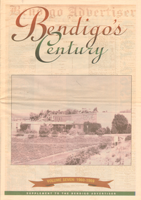
Newspaper - LONG GULLY HISTORY GROUP COLLECTION: BENDIGO'S CENTURY VOLUME SEVEN: 1960 - 1969
Supplement to the Bendigo Advertiser, December 15, 1999 Volume Seven: 1960-1969 titled Bendigo's Century. The front has a photo of the BCV 8 Studio. Contains photos and local news, council matters, planning, Who's Who, Weather, Sport and Business and some Advertisements. Photos include Early stages in the construction of the Eppalock tower and bridge pillars, Christine Wiseman, TV8's first news reader Ron Alderton, Dr Albert L Beischer, Advertiser buiding, fire at the Advertiser building, Oscar Flight, Bendigo Town Hall, William Basil Ashman, Lake Eppalock, Premier Henry Bolte, Que O'Hoy, Sandhurst Guest House, The Lyric Theatre, E C Thompson, The elm tree in Market Square, Leslie Galvin, The original Myer Store, The Joss House, Sidney Myer, Bendigo Police Barracks, Bunratty Castle, Albert Vivian Gray, The Victoria Hill site, Architects drawing of the new council administrative offices and Noel Beaton MHR.bendigo, history, long gully history group, the long gully history group - bendigo's century volume seven: 1960 - 1969, bendigo advertiser, bcv 8, eppalock dam, premier henry bolte, the criterion hotel, mccarthy family, teachers training college, bendigo original teachers college, long gully state school, stramit, bendigo university site committee, mrs christine wiseman, bendigo city council, the broadcasting control board, general television pty ltd, bendigo central victoria telecasters pty ltd, mr davidson, bennett's arcade, woolworth's, white hills swimming pool, herb elliott, sailor's guide, toni riley pharmacies, rising sun hotel, ron alderton, dr albert l beischer, channel 8, melbourne herald, 3bo, bendigo advertiser officeslyceum theatre, junior technical school white hills, mount alvernia hospital, most reverend dr b d stewart, sisters of the franciscan missionaries of the divine motherhood, lazarus family, bendigo's tramways, state electricity commission, george pethard, lance pethard, bendigo advertiser fire 29/7/1962, riverine herald, the herald and weekly times, bendigo art gallery, oscar flight, hollands foundry, eaglehawk u.f.s. dispensary, gillies famous pies, william basil ashman, golden gate hotel, grieves family, bendigo town hall, mr r r anderson, mr e h brown, cr neville oliver, cr tom flood, traffic commission, lansell family, abev-1, bendigo ordnance factory, actu, bendigo trades hall council, the ramsay report, bendigo benevolent home, bendigo home and hospital for the aged, princess theatre, amoco, lake eppalock, bendigo training prison, bendigo police station lock-up, shamrock hotel, rifle brigade hotel, hopetoun hotel, anz bank, marong shire offices, sir rohan delacombe, st paul's church, que o'hoy, waldron family, windermere hotel, aids & appliance shop, anne caudle centre, e c thompson, mayfair hams, sandhurst guest house, lyric theatre, chinese joss house, ordnance factory, sir john jenson, bridge street chinese quarter, bendigo city hall, cr r f turner, cr tom flood, victorian inland meat authority, new zealand insurance co, mrtropolitan security service, bendigo easter fair society, golden square high school, eaglehawk high school, bendigo technical college, mr ralph w birrell, bendigo fountain plaza, the bethlehem home for the aged, dick hazeldene, victorian egg board, bendigo united cricket club, south bendigo united cricket club, western mining corporation, les priest, alexandra fountain, bendigo advertiser, cr w cambridge, bendigo council, eaglehawk council, strathfieldsaye shire, huntly shire, marong shire, david thomas, senator john gorton, bendigo's college of advanced education, bank of new south wales, harp and shamrock hotel, the honorable leslie william galvin, kurmala, cain government, hanro knitting mills, myer store, sidney myer, davey brothers grocery store, national trust, myer emporium, myer's ltd, cox bros (australia) ltd, dame merlyn myer, baillieu myer, frank greenaway, institute of technology, gas & fuel corporation, bendigo railway station, anz bank, city family hotel, tab branch, senior constable alfred herbert wright, senior constable allan raymond brown, victorian football league, bendigo police barracks, camp hill state school, state electricity commission, the country party, the labor party, transport regulation board, stuart anderson, grose family, jean theodore de ravin, kyneton shire, sir william mcdonald, mines department, the loddon hospitals region group laundry and central linen service, kevin wynne, albert vivian gray, bradford cotton mills ltd, bradmill industries ltd, victoria hill, bendigo and district tourist association, professor brian lewis, melbourne university, victorian chinese community, loong, sun loong, stafford ellinson, coles' store, north deborah mining company nl, noel beaton mhr, durham ox hotel, taylor family -
 Bendigo Historical Society Inc.
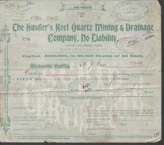
Document - KELLY AND ALLSOP COLLECTION: SHARE CERTIFICATES - HUSTLER'S REEF, IRONBARK, BENDIGO, 23/08/1902 to 25/01/1904
Documents. KELLY & ALLSOP COLLECTION. A series of Share Certificates issued by The Hustler's Reef Quartz Mining & Drainage Company, No Liability. Each certificate represents 50 shares at 4 pounds each. Capital raised was 200 thousand pounds from 50,000 shares. Certificates No.379, 384 issued to M.J.Carr on 23 Aug 1902. Certificate No.400 issued to G.H.Pearce on 23 Aug 1902. Certificates No.1427 - 1433 issued to N.Lloyd on 28 Oct 1902. Certificates No. 2259 - 2265 issued to C.Millman on 10 Aug 1903. Certificates No.2714, 2715 issued to N.Lloyd on 25 Jan 1904. Each certificate is pale green in colour and has a plan of the mine on the back. Printed by J.B.Young, Bendigo. Certificates dated 1902 are signed by the Manager Henry Y North and later certificates signed by G Stanfield for the Manager. 19 certificates in total.Hustler's Reef Minebusiness, stockbroker, kelly & allsop, kelly & allsop collection, hustlers reef mine, share certificates, henry y.north, g.stanfield, m.j.carr, g.h.pearce, n.lloyd, c.millman -
 Clunes Museum
Book, Percy, John, Percy's Metallurgy - Iron & Steel, 1894
Dowlais is a former Iron/steel making and coal mining town in Wales, United Kingdom.1 Hardcover book light brown embossed cover, gold lettering on spine, 1864, subject matter, the art of extracting metals from their ores and adapting them to various purposes of manufacture. With illustrations, chiefly from original drawings, carefully laid down to scale. .2 Newspaper Article "Dr. Percy on Iron and Steel" published in The Times Tuesday, May 17, 1864 .3 Plan for Dowlais New Mills Gold Lettering on spine: "Percy's Metallurgy Iron & Steel London John Murray Faded Maroon stamp page 2 - Clunes School of Mines No. 24 16 Jun 93metallurgy, mining -
Clunes Museum
document
... AND EXTRACTION, PLAN OF GOLD MINING COMPANIES... Charing Cross London 1882) .5 PLAN OF GOLD MINING CO'S. CLUNES... Cross London 1882) .5 PLAN OF GOLD MINING CO'S. CLUNES (Extract ...INFORMATION ABOUT A STAMP SHOE FROM A CORNISH STYLE SQUARE-HEAD STAMP BATTERY POSSIBLY USED BY PORT PHILLIP MINE, CLUNES, FROM MATTHEW CHURCHWARD, SENIOR CURATOR, ENGINEERING & TRANSPORT, MUSEUM OF VICTORIA LETTER DATED 15 OCTOBER, 1997. THE GOLDFIELDS AND MINERAL DISTRICTS OF VICTORIA. GOLD ITS OCCURRENCE AND EXTRACTION, PLAN OF GOLD MINING COMPANIESINFORMATION RECEIVED REGARDING THE PORT PHILLIP MINE; Including .1 COPY OF ARTICLE 12TH MAY, 1858 FROM "THE ARGUS." MELBOURNE. .2 LETTER FROM "SCIENCEWORKS" TO MR. ALAN KEEBLE DATED 15/10/1997 (3 Pages) .3 SECTION OF MERCURY, TROUGHS, STAKES & STAMPS (Extract taken from publication, The Gold Fields, Mineral Districts of Victoria, by R. Brough Smyth F.G.S, published by Queensberry Hill Press 1979) .4 GOLD. ITS OCCURRENCE AND EXTRACTION (Extract taken from publication, Gold: Its Occurrence and Extraction by Alfred G. Lock F.R.G.S published by E. & F. N. Spon 16 Charing Cross London 1882) .5 PLAN OF GOLD MINING CO'S. CLUNES (Extract taken from Dicker's Mining Record 26/3/1867, page 173. https://trove.nla.gov.au/work/32734386?q&versionId=39944948) local history, mining, company exploration -
Clunes Museum
Map - MAPS/ DOCUMENTS, CIRCA 1857
COLLECTION OF DOCUMENTS (COPIES OF10 MAPS AND DIAGRAMS OF TOURAAL PURCHASED UNDER PREEMPTIVE RIGHT BY DONALD CAMEROM 17TH FEBRUARY, 1857. COUNTY OF TALBOT - GOLDFIELD'S SURVEY PLAN NO.1 CLUNES COUNTY OF TALBOT. GLENDONALD - CRESWICK/CLUNES.local history, mining -
Clunes Museum
Plan - PLAN/MAP, SOUTH CLUNES GOLD MINE
... Clunes Museum 36 Fraser Street Clunes goldfields PLAN ...PLAN AND MAP OF SOUTH CLUNES GOLDMINEPLAN OF SOUTH CLUNES UNITED G.M.CO.CLUNES PRODUCED OR DRAWN BY F.W.NIVEN & CO LITH BALLARATlocal history, document, mining, plans -
Clunes Museum
Plan, 23RD SEPTEMBER,1854
GEOLOGICAL SKETCH PLAN AND LETTER FOR TWO RIGHTS CLAIMED BY DONALD CAMERON AT "CLUNES" - 320 ACRES IN THE WEST SIDE OF "CRESWICK CREEK" AND 160 ACRES IN EAST SIDE.1 .2 HANDWRITTEN GEOLOGICAL SKETCH/PLAN COMBINED WITH CORRESPONDENCE DATED 23 SEPTEMBER 1854 - FROM THOMAS BURR, SURVEYOR, 1854 AND PROVIDED TO THE SURVEYOR GENERAL. IT RELATED TO TWO RIGHTS CLAIMS BY PRESCRIPTION OF DONALD CAMERON ESQ.local history, plan, donald cameron, thomas burr, gold mining -
Clunes Museum
Map, F.W. NIVEN EMBOSSER
SCROLL - SURVEVOR MAP AND PLAN OF NEW CRESWICK GOLD FIELDS SURFACE LEVELSlocal history, document, maps, mining - maps -
Stawell Historical Society Inc
Archive, Stawell Gold Mine, Stawell Gold Mine Emergency Plan, 1/08/2015
... ventilation & Emergency Exits Plans and Conatacts. Mining Gold Date ...Plans produced by Mine for Emergency use showing ventilation & Emergency Exits Plans and Conatacts.Ring Bound A3 book with laminated Covers & Black and Yellow Banding for attentionDate of Issue 31/ 08/2015 Uncontrolled Copymining, gold -
Stawell Historical Society Inc
Archive - Books & Papers, The Australian Sketcher Article Stawell and the Pleasant Creek reefs July 12 1873, July 12 1873
Article printed after legislation arising out of 'Jumped Claims' back in history of Pleasant Creek - alluvial and quartz mining Currant mining operationsPhotocopy of article with lithographs and plan of Stawell -
Stawell Historical Society Inc
Map, Fred W Wright Surveyor, Plan of the Borough of Stawell showing Mining leases & reefs 1870, 1870
Mining details. Including Tramways, Water Races. Crushing Mills. Reefs and Reserves.Copy of Original Showing Stawell Borough with details including mining leases Companies and MillsInsert with details of Sections 23, 34, 35 & 36. Fred W Wright 12 May 1870mining -
Stawell Historical Society Inc
Map, Underground Mine Workings Stawell, 1894
... grampians Stawell Mining Plans Plan and Elevations of mine workings ...Plan and Elevations of mine workings 12 September 1894. J H Bate Mining Surveyor. Framed under Glassstawell, mining, plans -
Stawell Historical Society Inc
Map, Stawell Gold Mine, Provisional Plan Wonga Area, c1980
c1980 Preliminary Provisional Reconnaissance Plan Showing Workings Above and Below water LevelWonga Area 1:1000 Base Geological Sheet mining, gold, map -
Stawell Historical Society Inc
Map, Western Mining Stawell, Germania Summary Plan & Geology Western Mining Corporation, September 1988
... Germania Summary Plan & Geology Western Mining Corporation...Germania Summary Plan & Geopogy Western Mining... grampians mining gold map Germania Summary Plan & Geology 2003-566 1 ...Germania Summary Plan & Geopogy Western Mining Corporation Stawell VicGermania Summary Plan & Geology 2003-566 1:1000 mining, gold, map -
Stawell Historical Society Inc
Map, Gold Mines of Australia, Gold Mines of Australia underground workings. Newington Rd Darlington Rd Area 1950, 1950
Plans Showing Surveys & Drilling Stawell InvestmentGold Mines of Australia Stawell Investment 2003 mining, gold, map -
Stawell Historical Society Inc
Map, Gold Mines of Australia, Geological Plan Wonga Mine Area Stawell Investigation, 1950
Plans Showing Stawell Investment 1950Gold Mines of Australia Ltd mining, gold, map -
Stawell Historical Society Inc
Map, Gold Mines of Australia, Stawell Investment Geological Plan. Mine Area showing Mineshafts
The Reefs Mine shaft locationsGold Mines of Australia Ltd mining, gold, map -
Stawell Historical Society Inc
Map, G C Birch Mining Surveyor, Magdala Cum Moonlight Co. Plan of Stawell Goldfield, c1900
Shows Sloanes & Scotchmans Coy AreaShowing underground drives. c1900G C Birch Mining Surveyor mining, gold, map -
Stawell Historical Society Inc
Map, Gold Mines of Australia, Plan of Stawell Goldfield. Mining Leases, 1952
... Plan of Stawell Goldfield. Mining Leases. ... Locations 1952 Plan of Stawell Goldfield. Mining Leases. Map Gold ...And Shaft Locations 1952 G G Birch Mining Surveyormining, gold, map -
Stawell Historical Society Inc
Map, Stawell Joint Venture, Mine Site Detail Plan, September 1989
1989mining, gold, map -
Stawell Historical Society Inc
Map, H C Bates Surveyor, Plan of Underground Workings. 1888, 25/8/1888
goldMagdala Co Now Moonlight Co StawellScale 80ft to an inch H C Bates Mining Surveyor 25/8/88mining -
Stawell Historical Society Inc
Map, MPI Mines, Plan View of Township Area 2003, 13/6/2003
goldShowing known gold workings & Houses Stawell Gold Mines. 13 June 2003 1 : 7500 MPI Minesmining -
Stawell Historical Society Inc
Map, MPI Mines, Plan View of Township Area 2003, 13/6/2003
goldShowing known old gold workings Stawell Gold Mines. 13 June 2003 1 : 7500 MPI Minesmining -
Stawell Historical Society Inc
Map, Northern Grampians Shire, Town of Stawell Planning Scheme, 1981
Amendment No 21 (1981) Scale 1 : 3168 ie 4 Chains = 1 inchmining, gold -
Stawell Historical Society Inc
Map, Stawell Gold Mine, Plan Showing Wonga Pit and Underground Development, August 2001
Stawell Gold Mines Victoria Scale 1 : 2500mining, gold -
 Rutherglen Historical Society
Map, 1908
This is a map produced as part of a book entitled.. It is also stamped on the back in blue ink with an oval ring and the words North of England Institute. Newcastle. Mining & Meterolgical Faculty. Purchased on 23rd July 2017 by the Society after research by member Simon Killeen. Mining map of one of the first mines in Rutherglen area ( Chiltern West)Cream paper, black printing, rectangle with a drawingGeographical Survey of Victoria, Memoir, No6. Plate XX Plan of Underground Workings CHILTERN VALLEY CONSOLS MINE, RUTHERGLEN, PARISH OF CHILTERN WESTgold, rutherglen, mining, chiltern, underground mine map, geological survey, reef drives -
 City of Ballarat Libraries
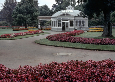
35 mm Slide, Statuary Pavilion, Ballarat Botanical Gardens circa late1950s
James Russell Thompson (1818-1886) a successful mining investor and stockbroker of the Ballarat Stock Exchange, gifted the pavilion and the statues within, as a 10,000 pound bequest to the City in his will. The pavilion, designed by architect T.E. Molloy on an octagonal plan with a convex curved roof, was constructed in 1887, and houses the statues Flight from Pompeii, Rebekah, Susannah, Modesty and Ruth. The pavilion is a major feature of the Ballarat Botanical Gardens, and unique in Victoria. It is a favourite subject for photographers, and Mrs Strange has captured it surrounded by massed small begonias. Mrs Bon Strange and her husband Bert were well known Ballarat residents. When Mrs Strange died some years ago, her extensive slide collection was sorted through and those relevant to Ballarat were gifted to the Ballarat Library. botanical gardens, lake wendouree, james russell thompson, statuary pavilion, weighing machine -
 Old Colonists' Association of Ballarat Inc.
Photograph - Photograph - Colour, Ballarat Old Colonists' Association Homes, Charles Anderson Grove, Ballarat
HISTORY OF THE BALLARAT OLD COLONISTS' ASSOCIATION HOMES AT CHARLES ANDERSON GROVE, LAKE GARDENS One of the original objectives of the Association was “to provide the shelter of a house for those Pioneers of the Goldfields whom the reverses of fortune have deprived of the means of procuring the comforts of life in their declining years.” While the first home at Charles Anderson Grove was built in 1925 the Association had previously provided relief for needy pioneers from the time it was formed in 1883. Relief included monthly monetary payments, loads of firewood, medical assistance and distribution of Christmas boxes of groceries to deserving pensioners and in some cases payment of burial costs. Records indicate that in September 1922 three of the pensioners being assisted by the Association were accepted as residents in the newly erected Hassell Homes in Gillies Street (now demolished-opposite the High School). The first site for an Asylum for Indigent Members of the Old Colonists' Association was temporarily reserved from sale in October 1891. The site was approximately 28 acres in area in Mt Clear nearly opposite Midvale Shopping Centre in Main Road. The site was heavily timbered and when cleared over 260 tons of wood was sold to the Woah Hawp Gold Mining Company. A set of gates were erected but no homes built, although a plan for this reserve was drawn which showed twenty buildings ranging from one to four unit per building. The reserve was revoked in November 1909. The second site temporarily reserved in November 1909 as an Asylum was in Alfredton and consisted of some 7 acres and was adjacent to land reserved for an Abattoirs for the Ballarat Council. The reserve was revoked in February 1912 as it was deemed more appropriate to be added to the Abattoir site. Council suggested four (4) other sites in exchange for this land and they were inspected by the President, Vice President and Secretary on 22 December 1912. The first site inspected was land on the west side of Creswick Road opposite the brick kilns (now occupied by the showgrounds and oval). The land was described as being good quality, well fenced, no trees, good drainage and ample acreage but some distance from trams. The second site was Perry Park which was described as being good land, well fenced, having frontage to Gillies Street, good drainage and about 26 acres (but subsequently reduced to 10 acres). It was closely planted with Pinus Insignias and Wattle and had easy access from the Botanic Gardens tram. The third site was the North West portion of Victoria Park (corner of Sturt and Gillies Street) and was described as good land, well fenced and drained and well located. The fourth site was the South West corner of Victoria Park and known as Pound Paddock (corner of Winter Street and Gillies Street). It was considered to be low lying and too close to the Abattoir, and was also a considerable distance from trams. While the third site was recommended as the most suitable for the erection of homes it was considered unwise from the point of view as citizens to reduce the acreage of the park and therefore it was recommended that the Perry Park site be asked for as the most acceptable to the Association for the building of homes. The site was eventually temporarily reserved for an Asylum for Indigent Members of the Association in April 1914 with the gates from Mt Clear having been removed to the site a year earlier and eventually erected in 1917 for £12.10.0. In the same year the first 290 pine trees were advertised for removal in July and sold for £16. A sign indicating that the site was reserved for the erection of cottages was erected in September 1917. Stripping of the wattle bark (for tanning) and the cutting of the wood occurred in November 1918 with the land then being leased until it was required for the construction of the first homes in 1924. While the site was the third to be reserved it was the only one which was used for its intended purpose. It was named as Charles Anderson Grove in honour of Charles Anderson who joined the Association in 1918 and was President of the Association from 1942 to 1944. A number of cottages in the Ballarat Old Colonists' Association Retirement Village of Gillies Street, Ballarat.charles anderson grove, old colonists' club, ballarat, old colonists' association, old colonists' homes, retirement village