Showing 391 items
matching pedestrianism
-
 Melbourne Tram Museum
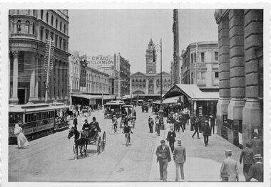
Photograph - Black & White Photograph/s, c1905
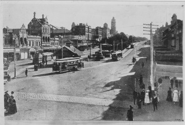
Photographs, Black and White, Photo of Elizabeth St, to the north of Collins St looking south towards Flinders St and Flinders St Station. Has a bogie cable trailer in the view, along with other cable trams, horse drawn vehicles and many pedestrians. In the background is Royal Bank, Craig Williamson, Sargent's Cafe and R. White on the corner. The photograph has a serrated edge.In ink on the rear: Keith Kings stamp and number S-A-449 "Melbourne - Elizabeth St, looking south over Collins St. About 1900. Note Bogie Cable Trailer"trams, tramways, elizabeth st, collins st, cable trams -
 Bendigo Military Museum
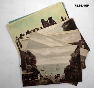
Postcard - POSTCARDS, PHOTOGRAPHIC, VARIOUS U.K, c. WW1
Postcards collected by R.H. Baron while on leave in England during WW1. Part of the "Robert H. Baron" (No. 3596) and Cooper Collections. See Catalogue No. 1981P for details of Baron's service. 1. Coloured coastal scene featuring yachts, beach goers and cliffs. People are standing on a pebbled beach. 2. Coloured coastal scene featuring cliffs and ocean. 3. Coloured coastal scene featuring beach, bathing machines, cliffs and town buildings. 4. Coloured coastal scene featuring beach with boats and town buildings. 5. Sepia toned photograph featuring houses. Stream running in front of house. Footpath between stream and house. 6. Coloured street scene featuring houses fronting a gravel road. 7. Black and white photograph of a street scene featuring buildings, pedestrians and horse drawn transport. 8. Sepia toned photograph of a street scene. Right side lined with houses. Single pedestrian on footpath. 9. Coloured scene featuring standing stones. 10. Coloured photograph of a ruined building overgrown with vegetation.1. Ladram Bay. 2. Ladram Bay. 3. Budleigh Salterton from East. 4. Budleigh Salterton from West. 5. Budleigh Salterton, Cottages at the Granery, 6. Budleigh Salterton, West Terrace. 7. High St. Budleigh Salterton. 8. Budleigh Salterton, Station Road. 9. Stonehenge. 10. Abbey Ruins, Waverley. robert h. baron, cooper collection, postcards, ww1 -
 Ballarat Tramway Museum
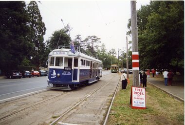
Photograph - Colour Photograph/s - set of 37, Warren Doubleday, 7/03/2004 12:00:00 AM
Set of 37 photographs taken or arranged by Warren Doubleday on 7/3/2004 during the 2004 Begonia Festival, which was sponsored by Alstom, featuring on the destination boxes, stop signs and tramcars and clothing worn by BTM staff. All taken in Wendouree Parade. .1 - 671 waiting for 27 to enter the crossing loop .2 - 671 and 27 in loop .3 - ditto .4 - people boarding No. 27 with Carolyn Dean observing .5 - ditto, with Peter Winspur in background .6 - 671 in loop .7 - 27 and 671 in loop, with people leaving 671 .8 - 661 in Wendouree Parade, at pedestrian crossing .9 - 671, 27 and 661 in loop .10 - ditto with people leaving 661 .11- 661 in loop passengers boarding, John Clowes in photo .12 - 33 and 671 at pedestrian crossing .13 - ditto .14 - 27 side on .15 - 33, 671, 661 and 27 in or near loop .16 - ditto .17 - 33 at pedestrian crossing .18 - 661 side on .19 - 33 at pedestrian crossing with people board .20 - 33 side on .21 - ditto .22 - 661 near crossing .23 - 27 side on .24 - 27 in loop with people leaving .25 - 27 in loop with people waiting to board .26 - Robert Paroissien standing by 27 with 671 in background .27 - ditto .28 - Sam Boon issuing tickets inside 33 .29 - ditto .30 - Sam Boon giving bells .31 - Len Millar and 27 at Depot Junction .32 - 671 at depot junction .33 - Len Millar at 33 at Depot Junction .34 - 33 at Carlton St, with Ben Shields .35 - 27 at Carlton St from the Prisoners of War memorial .36 - ditto .37 - as for .25btm, begonia festival, alstom, wendouree parade, tram 33, tram 27, tram 661, tram 671 -
 Phillip Island and District Historical Society Inc.
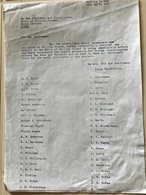
Document, Petition for bridge between Phillip Island and San Remo 1937
On 29 November 1940, a suspension bridge opened between San Remo on the mainland and with Newhaven on Phillip Island. The 540 metre bridge had two lanes but no footpaths, instead having six pedestrian refuges. The main span was 168 metres long. The cables had previously been used on a bridge on Sydney's North Shore. Because of weight restrictions, tourist coaches had to offload their passengers. [Wikipedia]HistoricalFoolscap size photocopy of a petition to Shire of Phillip Island for a bridge to Phillip Island in 1937. Signed by 42 local residents and ratepayers.first phillip island bridge to san remo, phillip island suspension bridge, petition, odlum, ockleford, regos, mcguigan, west, mcfee, richardson, underdown, mcmaster, cleeland, neely, leeson, saunders, scott, brown, hislop, donnellan, rackham, findlay, anderson -
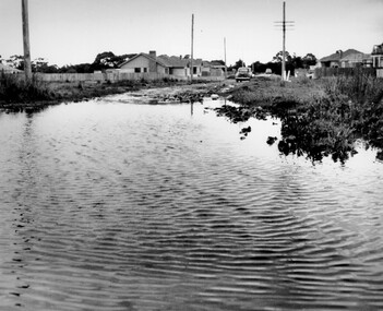 City of Kingston
Photograph - Black and white, c. 1958
This photograph depicts flooding of Ozone Avenue in Beaumaris, located off Balcombe Road. Roads in the Beaumaris area lacked sufficient drains to clear surface water. In many cases streets were unsealed and without footpaths and some were dirt tracks. Gutters and road surfaces were made of clay and in the wetter months of winter, unsealed roads and tracks became impossible quagmires that were unnavigable for vehicles and pedestrians. In the first decade after World War II there was rapid expansion in construction of new houses in the suburb of Beaumaris. Utilities and infrastructure to support the growth of housing was inadequate and not provided for prior to the development of the area. Without rudimentary drainage, flooding was frequent. Storm water runoff, domestic sullage and septic tank overflow would form large pools and families were sometimes marooned within their homes. The frequent flooding caused isolation and hardship and residents endured difficulties with accessibility to facilities. These disadvantages had the potential to cause social issues for the new residents.Black and white photograph of flooding in Ozone Avenue, Beaumaris. The image shows floodwaters with boggy and rough terrain on an unsealed road with housing in the distance.Handwritten in blue ink: 2124 circled Handwritten in red ink: 80% Handwritten in blue ink on yellow Post-It note: Chap 6. underlined, 2194 Ozone Ave Beaumaris 1958beaumaris, ozone avenue, balcombe road, flooding, roads, infrastructure -
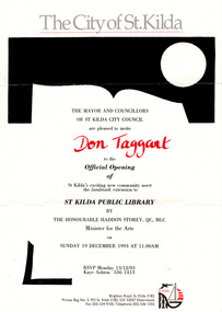 St Kilda Historical Society
Ephemera - Invitation, Official Opening of extension to St Kilda Public Library, 1993
Invitation to the official opening of an extension to the St Kilda Public Library by the Victorian Minister for the Arts, the Hon Haddon Storey QC MLC, on 19 December 1993. The floor area of the library was enlarged to include a new entry, ramp, and a pedestrian thoroughfare extending between Carlisle and Duke streets. The original entry was was blocked and a bluestone screen wall, evoking the form of an open book, was introduced to the west of new entry. Single sheet of white paper printed in grey, black and red, with St Kilda logoDon Taggart (invitee) st kilda town hall, st kilda town hall fire -
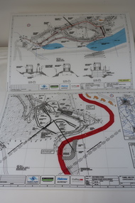 Kiewa Valley Historical Society
Plans - Southern Hydro - Bogong Power Development
Southern Hydro owned the Kiewa Hydro Electric Scheme in May 2006 when these plans were created. The Site No. 1 and Site No. 2 are part of the Bogong Power Development Bogong Power Development is part of the Kiewa Hydro Electric SchemeLaminated A3 plans mostly black and white but with a little color and surrounded by a grid.(Also see KVHS 1439) 1. Tunnel and Civil works / Commissioners Lodge Site Plan 1: Site No. 1 / TBN /Water /Supply / Reservoir Site 2. Tunnel and Civil Works / Pedestrian Diversion Access Paths / and Tracks: Site No. 2 / Lake Guy Site / Bogong Victoriabogong power development, southern hydro 2006 -
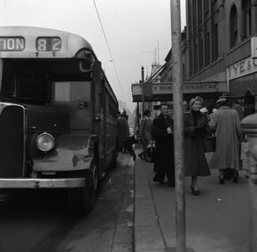 Ballarat Tramway Museum
Negative, Geoff Grant, 16/06/1955 12:00:00 AM
Negative No. N305 and black and white print made by a laser printer (stored in folder ) of a Bourke St Bus loading passengers at the Exhibition St. stop in Bourke St. on the north side. Tyes home furnishers building in background, along with a many pedestrians. Negative scanned hi res and imaged updated 20/5/2020. Note the bus has a Port Melbourne depot run numbertrams, tramways, melbourne, bourke st., buses, exhibition st., port melbourne -
 Ballarat Tramway Museum
Photograph - Black and White photograph/s - mounted, John Phillips, c1971
Yields information about the city tram terminus, Sturt and Lydiard c1971 and the motor vehicles in use.Black and White photograph mounted on heavy cardboard backing. Photo of Ballarat No. 26 with the destination of Victoria St at the city tram terminus in Sturt St. Has many motor vehicles in the photograph along with some pedestrians. Town Hall in the background. Has parts of old support tape on rear. Note image scanned in two runs through a scanner, resulting in the shading in the image file.trams, tramways, sturt st, town hall, city, tram 26 -
 Surrey Hills Historical Society Collection
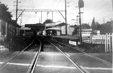
Photograph, Surrey Hills railway station, 1973, 1973
This would have been taken shortly before the station was demolished.Black and white photo of Surrey Hills railway station taken from the tracks near the gates in 1973. It shows the wooden pedestrian overpass and the original station buildings with extended shelters over the platforms.There is a newspaper kiosk on the southern platform. The train is coming into the platform and there is a small group of passengers waiting. Advertising hoarding for Spaceline Homes and the Frankston Caravan Park are mounted at the end of the southern platform. railways, land transport, surrey hills railway station -
 Bendigo Historical Society Inc.
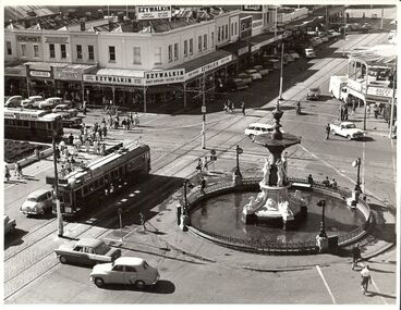
Photograph - BASIL MILLER COLLECTION: TRAMS - ALEXANDRA FOUNTAIN, 1964
BHS CollectionBlack and white photo of Alexandra Fountain, Charing Cross, Bendigo. Two trams - View Street and Pall Mall, at intersection of same. Many cars parked, driving on roads. Pedestrians crossing Pall Mall. On back of photo "Photo A. Doney, Bendigo" in indelible ink. 10/23/64 CA 711, Bendigo Center - Charing Cross & historic Alexandra Fountain written in pencil.A. Doney, Bendigoperson, individual -
 Ballarat Tramway Museum
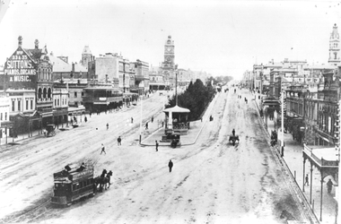
Photograph - Tram 20 -City Centre, c1910
Photograph of Ballarat Summer car No.20 and 3 other tramcars (2 with former double deck horse tram trailers) at City Centre, Nth side of Sturt St at Grenville St Nth. Photo shows the large passenger shelter/ESCO office, several pedestrians, and the commercial buildings of the Eastern end of Sturt St. Prominent in the background are the Mechanics Institute, and the Town Hall. See item 5134 for a digital image and a copy negative.Yields information about SEC tramway operations, and the buildings and layout of the East end of Sturt St.Black and white photograph on plain paperHas details of photograph and year on rear and number "T30". Also, "Ballarat Tramways", "Sturt Street in 1912", "Showing 3 old el types, 2 trailers and No.20 summer car(near band stand), "W.Jack Photo".ballarat, sturt st, tram 20, horse tram trailer -
 Ballarat Tramway Museum
Photograph - Horse Trams Sturt St at Grenville St, c1904
Photograph shows a horse tram leaving the Grenville St terminus to travel on the north side of Sturt St. Photo from the top of the Nicholl and Allan building. In the background are many pedestrians and one horse drawn car. There is a telegraph/telephone pole line on the right hand side of the photo. See items 5103 for a close up reproduction photo of the horse tram, 836 for a black and white reproduction and 2437 for a coloured postcard of the same image.Yields information about Sturt St c1904 and horse trams.Black and white photograph on plain paperhas "3" in a circle and "4" crossed out on the rear.tramcars, trams, horse trams, sturt st, postcards, grenville st. -
 Melbourne Tram Museum
Photograph - Black and White - St Kilda Junction c1900 looking along Wellington Street
The photograph shows St Kilda Junction c1900, looking towards Wellington Street from the centre of the junction. A Windsor (Chapel Street to Ackland Street) cable tram is turning the corner while another is approaching. There is a cable tram uniformed person (with his hands on his hips) watching the tram - possible an Inspector. In the view is: AA Sleight Undertaker, Miss Nichols St Kilda Floral Studio, street lights, and a number of pedestrians standing on the roadways.Yields information about cable trams and St Kilda Junction.Photograph - Black and White - St Kilda Junction c1900 looking along Wellington Streettramways, trams, cable trams, st kilda junction, inspectors -
 Melbourne Tram Museum
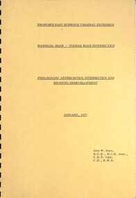
Document - Report, John Knee, "Warragul Road - Toorak Road Intersection", Jan. 1977
Report - "proposed East Burwood Tramway Extension - Warragul Road - Toorak Road Intersection - Preliminary Appreciation intersection and shopping redevelopment - Jan. 1977". Prepared by John W Knee for the MMTB and others. Looks at the intersection, how the shopping centre could be accessed, possible Mall development, residential issues, passenger facilities and pedestrian capacity. Includes a number of possible access routes for the area. None were applied when the tram line was extended.Yields information about a consideration for the extension of the Toorak Road line to East Burwood in 1977.Comb bound report with clear plastic covers, brown covers, 17 A4 pagesmmtb, east burwood, toorak road, warragul road, new tramways, john knee -
 Ballarat Tramway Museum
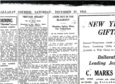
Document - Photocopy, Alan Bradley, "Look Out in the Blackout" - 27/12/1941, Mar. 1998
Photocopy of an item (enlarged) that appeared in the 27/12/1941 Ballarat Courier about Wartime (2nd World War) Safety Hints for Pedestrians. Notes actions that should be taken about boarding or alighting from tramcars, walking along roads and also accident statistics from Britain during the first four months of WWII. Used in a 1998 Fares Please! Photocopy supplied by Alan Bradley in March 1998. trams, tramways, ballarat, world war ii, blackouts, safety -
 Melbourne Tram Museum
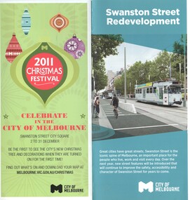
Pamphlet, City of Melbourne, "Swanston Street Redevelopment", Nov. 2011
Pamphlet, 2 fold DL, printed on gloss paper, titled "Swanston Street Redevelopment", with a tram (Z3) at the State Library and showing the bicycle lane. Has a map showing the various stops and when the upgrades will be done, details of the stop, cycling, pedestrians, authorised vehicles, taxis, and timing. Issued by the City of Melbourne November 2011 (has advert for the cities 2011 Christmas Festival) on the rear. 2 copies held.trams, tramways, swanston st, tram stops, reconstruction, city of melbourne, tram c3005 -
 Melbourne Tram Museum
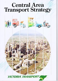
Document - Report, Victoria Transport, "Central Area Transport Study", Mar. 1991
Report - 28 pages + card cover, centre stapled, titled "Central Area Transport Study", produced by Victoria Transport as part of the Central Area Transport Strategy (CATS), with a forward by the Minister for Transport, has a table of contents, figures and tables. Provides a set of Action Plans, looks at future, implementation, options, roads, tram and rail lines, cycle and pedestrians. See Reg Item 471 for a 1988 draft.In ink on top right hand corner "(1991)",trams, tramways, public transport, melbourne, road transport, the met, minister for transport -
 Eltham District Historical Society Inc
Photograph, George Coop, Copy of a photo of Steam locomotive Y-103 at Newport Railway Station, c.1951, 1962
The Melbourne Road level crossing is now the location of the pedestrian underpass. Hall Street is seen to the right and the two-storey brick building remains to present day One of several photos at Newport taken the same day in the early 1950s when George Coop was a secondary school student. This photo is a 35mm copy (1962) of an original print of the c.1951 negative - possibly to use up the last frame after photographing several other early VR prints.Digital TIFF file Scan of 35mm Ilford FP3 black and white transparencygeorge coop collection, hall street, level crossing, melbourne road, newport railway station, y-103, y-class steam locomotive -
 City of Kingston
Photograph - Black and white
This photograph depicts the road diversion on Nepean Highway that was implemented to allow construction of the railway line underneath the Nepean Highway at Moorabbin. An "Allourie" Cheese, Honey Canned Ham van is prominent on the left of the image, the railway gates are central and the old Moorabbin Station is visble. Beyond the dates, pedestrians are visible crossing the Nepean Highway. This image is part of a larger collection of images from the Public Transport Corporation displaying train stations and streetscapes in what is now the City of Kingston.In 1958 excavations began for the removal of the level crossing gates at the southern end of the Moorabbin shopping centre on Nepean Highway. The station was also lowered below ground. A diversion route was created to enable the flow of traffic in both directions along the highway.Black and white photograph of road diversion on Nepean Highway, Moorabbin to allow the construction of the railway line below the Nepean Highway at Moorabbin and also to trench the station. This image is part of a larger collection of images from the Public Transport Corporation displaying train stations and streetscapes in what is now the City of Kingston.White adhesive dot sticker: Printed black 199 Handwritten in red ink: 80% Handwritten in black ink on yellow Post-It Note: [indecipherable] 199 - Diversion for Crossing Stamped in blue ink: COPYRIGHT Public Transport Corporation, For reordering photographs, Please quote negative No m 5687, Enquiries C/- PTC Photographic Unit, Telephone switchboard 619 1111railway crossing, railway station, city of moorabbin -
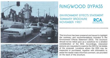 Ringwood and District Historical Society
Newsletter, Ringwood Bypass Environment Effects Statement Summary Brochure - November 1987
8-page A4 size brochure issued by Road Construction Authority reporting on the proposed Ringwood Bypass. Topics include Community Consultation, Estimated Capital Costs, Traffic Effects, Property Effects, Mullum Mullum Creek, Landscape Development, Pedestrian/Bicycle Access, Noise, Air Quality, Compatability with Ringwood District Centre Development, Vehicle & Traffic Aspects, Lighting, Construction Impacts, Extension to Canterbury Road, Public Transport. -
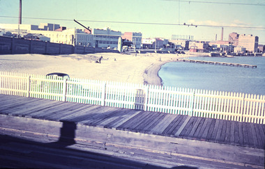 Port Melbourne Historical & Preservation Society
Photograph - Port Melbourne beach front from Station Pier, February, Marie Hillier, Feb 1960
Digital image taken from Station Pier, in February 1960, looking east along beachfront. Image shows part of Centenary Bridge; Swallow and Ariell buildings including chimney (since demolished); London Hotel; Princes St drain pier; Graham St gasometer in background; Sandridge Bay Towers; rotunda. Station pier shows raised pedestrian walkway, vehicle on lower level and rails that extend from station.built environment - commercial, built environment - industrial, natural environment - beaches and foreshore, piers and wharves - station pier, centenary bridge, london family hotel, band rotunda, swallow & ariell ltd, gasometer, sandridge towers, piers and wharves - miscellaneous -
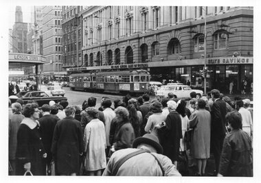 Melbourne Tram Museum
Photograph - Black & White Photograph/s, Keith Kings, 24/10/1968 12:00:00 AM
Photograph, Black and White, Photo of the intersection of Bourke and Elizabeth St at evening peak on 24/10/1968, 5.35pm. SW6 872, route 20 to Coburg and W5 740 at the Safety Zone tram stop. Many pedestrians heading towards Flinders St station . In the background is the State Savings Bank and London Stores. The man bending over is possibly a newspaper seller given the leather straps around his back.In ink on the rear: Keith Kings stamp and number 44-23 "M&MTB SW6 872 and W5 740 in Elizabeth St at Corner Bourke St, city 5.35pm 24/10/68" "1/60 @ f8 HP4"trams, tramways, elizabeth st, bourke st, sw6 class, w5 class, route 20, coburg, tram 872, tram 740 -
 Port Melbourne Historical & Preservation Society
Photograph - Railway Reserve, Sandridge, William Paterson, 1870s
One of a series assembled for the Melbourne Exhibition of 1873, original mount hanging in Engineering Department at Port Melbourne Town Hall at 19-9-1994. This set of prints belonged to Town Clerk Syd ANDERSON, then to his daughter-in-law Phyllis ANDERSON (donor). Accompanied by list of captions, both hand written and typed (the latter a partial listing). View from pedestrian bridge over railway, looking southeast over 'ornamental' Railway Reserve, 1870s. Probably taken from footbridge just north of Raglan Street; open space is believed to be swamp drainage area between Raglan and Spring Street. (Location usually attributed to Farrell Street - i.e. taken from footbridge at Bridge and Station, but this proves unlikely as there had been no construction on the swamp between Bridge and Farrell until later.)"P. Anderson" ink, on back:"10" ballpoint, on upper left face of phototransport - railways, built environment, parks and gardens, sydney sims anderson, town clerks, railway reserve, station street -
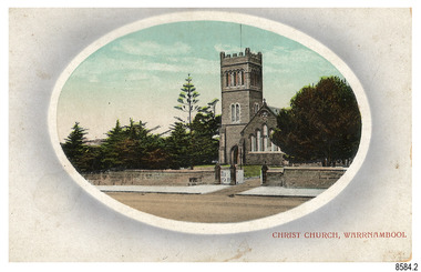 Flagstaff Hill Maritime Museum and Village
Postcard - Historical, Warrnambool, Christ Church, Warrnambool, Early 20th century
The nine postcards in this set were donated together and date to the early 1900s. All but one postcard in this set shows images of Warrnambool, in the Western District of Victoria; the other has a London image. The postcards were all printed in Great Britain according to that country’s postal regulations. The fronts of all cards have titles printed in red. Most of the images on the cards are attributed to photographer Joseph Jordan and belong to the Jordan Series. The back of these cards has an outline for a postage stamp, a vertical dividing line and a heading on each side of the line to separate the Correspondence from the Address. Postcards or ‘correspondence cards’ appeared in Britain in 1894. They were plain cards with a space for the message on one side and an address on the other; regulations didn’t allow anything but the address to be written on the ‘address’ side. In 1902 the British regulations then allowed a picture to be printed on the front and the address on the back, so messages had to be written on the picture side. Soon, the regulations changed and the back was divided for a message and the address. Christ Church Warrnambool – The image on this card shows Christ Church, a stone building built in 1856. The Anglican church is in Henna Street, Warrnambool. The church, outer buildings and grounds are heritage-listed. Its bell tower harbours German bells. Joseph Jordan - Joseph Jordan was born in 1841 in Leicester England. When he was 16 he joined the 7th Queen's Own Hussars and was sent to India at the outbreak of the mutiny. He took part in the relief of Lucknow and remained in India for eleven years. It was during this time, he became interested in photography. He was posted to New Zealand and later came to Victoria, becoming a sergeant major of the Mounted Rifles. In the mid-1880s he came to the Western district where he was responsible for establishing units of the Mounted Rifles in various country towns such as Dunkeld, Mortlake, Panmure, Bushfield, Koroit etc. He resigned from the army in 1889 and set up a professional photography studio in Liebig Street, Warrnambool. He became very well known in the Western District for family photographs, official photographs of local councillors and groups as well as views of local scenery. In 1891 he photographed the wrecked barque ‘Fiji’ at ‘Wrecks Beach’ near Princetown. His business was taken over by his son Arthur around 1917. Joseph was a keen rifle shot and in 1924 he donated the "Jordan Shield" as a prize to the Victorian Rifle Association. He was made a "Life Honorary Member" of the Warrnambool Returned Soldiers League and in 1933 he was recognised as being the oldest living soldier in Victoria. Joseph died in 1935 aged 95.This card is the only one of the nine cards with the location of Warrnambool added to the name 'Joseph Series'. It is also the only one that has text within the outline for the postage stamp. The font used for the test of the headings is slightly different to the other cards. Joseph Jordan is a significant figure in Warrnambool history as he helped to establish early units of the Mounted Rifles (G Company) in local towns during the late 1880's and later, photographed local scenes, groups and citizens of early Warrnambool. This postcard of Christ Church Warrnambool is significant for its connection to the church. The early building of the church in 1856, within the first decade of Warrnambool being proclaimed a town, shows the strong religious desire of the community. The church is part of Warrnambool's life events and the historical significance of the building,Postcard, one of nine, landscape orientation, coloured print within an oval border and mauve-toned shading. The cameo image is a stone castle-top bell tower beside a church building flanked by trees. A stone fence is across the front, with pedestrian and vehicle white picket gates. The title is in red print on the front of the card. There is no correspondence written on the card. The reverse has inscriptions and outlines for a postage stamp. Jordan Series, printed in Great Britain.Front, in red: “CHRIST CHURCH, WARRNAMBOOL” Back in black: “Jordan Series” “POST CARD” “PRINTED IN GREAT BRITAIN” “For correspondence” “The Address only to be written here”flagstaff hill maritime museum, flagstaff hill maritime village, flagstaff hill maritime museum and village, maritime museum, warrnambool, great ocean road, warrnambool and district, warrnambool scenes, local scenes, views of warrnambool, joseph jordan, jordan series, jordan photography, postcard, souvenir, correspondence, cameo postcard, landscape, christ church, bell tower, german bells, warrnambool church, religious building, stone building, anglican church, parish of warrnambool -
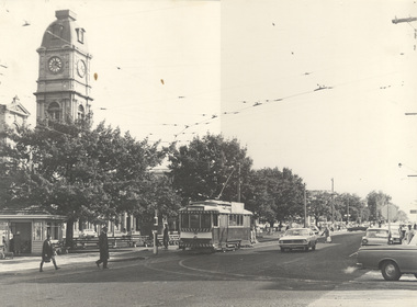
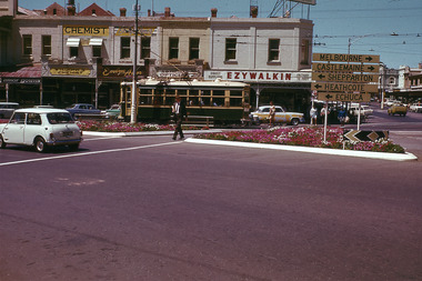 Bendigo Historical Society Inc.
Slide - Mouat Crawford Collection: Farming Life in the Wimmera, c1960s
BHS CollectionBendigo Charing Cross, corner Pall Mall and Mitchell Streets. Includes a tram, pedestrians and vehicles. Sign board directing traffic to Melbourne, Castlemaine, Shepparton, Heathcote, and Echuca. Stores in background include Ezywalkin Shoe store, A G Trelgar Optical, Evelyn Amor, W and T Jones Chemist, E G Amor Gowns. No traffic lights, tram line still going up Mitchell Street. Used as a teaching aid.ILFORDbendigo, charing cross, tram, pall mall, mouat crawford collection -
 St Kilda Historical Society
Photograph, St Kilda Library alterations 1993-94 - images collection, 1994
St Kilda Library was designed in 1971 by Enrico Taglietti (1926-2019). It was to be constructed in two stages. Stage 1 was completed in 1973. Stage 2 as designed by Taglietti did not proceed. Instead, alterations were designed in 1992-93 by Ashton Raggatt McDougall Architects (ARM). In 1993-94, the floor area of the library was enlarged to include a new entry and disabled ramp and a pedestrian thoroughfare between Carlisle and Duke streets. The original entry was blocked and a bluestone 'book' wall was constructed west of the new entry.colour photograph unmountedSK Libraryst kilda library, enrico taglietti, arm architects -
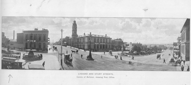 Ballarat Tramway Museum
Photograph - Illustration, "Lydiard and Sturt Streets", c1900
Illustration titled "Lydiard and Sturt Streets" - Centre of Ballarat, showing Post Office. In the bottom left-hand corner is a single-deck horse tram with a Havelock Tobacco advert on the roof. The illustration gives a sweeping wide angle view of the intersection with the Post Office marked with the words "Post Office". There are several horse-drawn vehicles and pedestrians in the view. The image has the initials "HJS" and "PS&Co" on both photos in the bottom corners. On the rear is a photo of the Gong Gong Reservoir with a note about its size and construction - built 1877.Yields information about a single deck horse tram and the intersection of Sturt and Lydiard StreetsIllustration cut from a magazine or publicationballarat, illustrations, sturt st, lydiard st, post office, horse trams, single deck horse tram, gong gong reservoir -
 Melbourne Tram Museum
Photograph - Black and white - Swanston St looking north from Flinders St, c1900
Photograph of Swanston St looking north from Flinders St. There is one cable tram set in the view along with many horse-drawn vehicles, bicycles, and many pedestrians. In the background is part of Young and Jackson's Princes Bridge Hotel, a sign for "New American system without pain Dentistry", Ayers Henry & Co. clothing, Stainer & Co., Keystone Elgin watches. Visible is an open wire telephone lines on poles. Photo c1900. Understood that the photo appears in the James Flood book of Melbourne photos.Yields information about Swanston St, c1900.Black and white photograph on paper.trams, tramways, swanston st, cable trams -
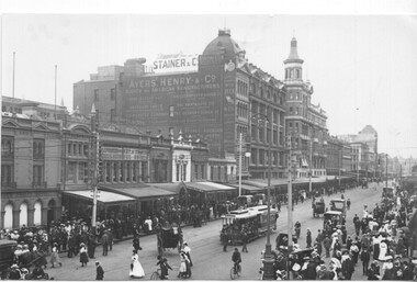
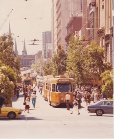 Melbourne Tram Museum
Photograph - Z2 class 111 and several other Z-Z2 trams in Bourke St Mall, early 1980s
Photograph looks east across Elizabeth St along Bourke St toward Parliament House. Z2 class tram 111, several other Z-Z2 trams and crowds of pedestrians fill the recently established (February 1978) motor-vehicle-free Bourke St Mall which is now filled with vegetation in large planters. No date is noted, but the recently built tram 111 and apparent absence of Z3 class trams indicate summer in the early 1980s . The Mall was officially opened by Prince Charles and Princess Diana in 1883Yields information about early years of Bourke St Mall Colour photographbourke st mall, z2 class, tram 111, bourke st