Showing 11214 items matching "planning "
-
 Melbourne Tram Museum
Pamphlet, Dept of Planning and Development, "Catch the City Circle", 1994
... Dept of Planning and Development ...Pamphlet - DL 6 fold from A3 sheet, full colour titled "Catch the City Circle", detailing the City Circle tram, 1994 - has the original route by Spencer St - map shows various points and details the various locations.. Has contact details but no web site. Has the Victoria government, Better Cities and Public Transport Corporation Logos. See Reg Item 866, 2703 and 1337 for other versions. Second copy added 24-04-2019 from Bob Prentice Collection.trams, tramways, city circle, yarra trams, ptc -
 Lakes Entrance Historical Society
Book, East Gippsland Regional Planning Committee, Sites of Historical Significance in the East Gippsland Region, 1980
... East Gippsland Regional Planning Committee ...Details of historical sites with comments about the money raising activities. History of construction..historic sites, charities, architecture -
Lakes Entrance Historical Society
Book, Central Planning Authority, Victoria, Resources Survey East Gippsland Region, 1954
... Central Planning Authority, Victoria ...A review of the physical, economic, and public resources of East Gippsland, Victoria.primary industry -
Lakes Entrance Historical Society
Book, East Gippsland Regional Catchment & Land Planning Board, Draft Regional Catchment Strategy 1996, 1996
... East Gippsland Regional Catchment & Land Planning Board ...Draft of regional catchment strategyPaperback 58 pageswaterways, planning committee -
 Narre Warren and District Family History Group
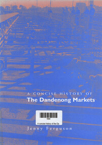
Book, Jenny Ferguson, A concise history of the Dandenong Markets, 1998
... City of Greater Dandenong (Heritage Planning) ...A short history of Dandenong's food and livestock markets.16 p.; 21 cmnon-fictionA short history of Dandenong's food and livestock markets.dandenong (vic.), dandenong markets, city of greater dandenong, -
Port Melbourne Historical & Preservation Society
Book, Ministry of Planning & Environment, South Melbourne's Heritage, Dec 1988
... Ministry of Planning & Environment ...Based on "City of South Melbourne Urban Conservation Study". Covers 1930s - 1960s.Paperback, illustrated guide to the history and development of South Melbourne "South Melbourne's Heritage" A4 sized book with coloured cover and blurred style picture of two women and children on Kerferd road pier in 1890s. Victoria Hotel in background. Book contains small black and white photos of buildings with descriptionsemerald hill, town planning, heritage, city of south melbourne -
Old Colonists' Association of Ballarat Inc.
Plan, R & R Planning and Development Consultants Pty Ltd, Drainage Plans for Charles Anderson Grove Retirement Village, 2016
... R & R Planning and Development Consultants Pty Ltd ...Three PDFs relating to drainage at the Charles Anderson Grove Retirement Village in Ballarat. charles anderson grove, retirement village, drainage, plans, sewerage, architectural plans -
Lakes Entrance Historical Society
Book, Department of Planning and Urban Growth/Department of Conservation and Environment, Draft Gippsland Lakes Management Plan, 1990
... Department of Planning and Urban Growth/Department of ...This document presents background information, policy directions, and actions need for improved management of the Gippsland Lakes.waterways, conservation, recreation -
University of Melbourne, Burnley Campus Archives
Map, Melbourne and Metropolitan Board of Works Plan No. 42 Richmond, c.1884-1891
Photocopy of Melbourne and Metropolitan Board of Works Plan No 42 M 387 ₍₄₂₎ of Richmond from plans dated c1884-1891. Shows A. Lynch's Plan of the Gardens. Scale 160 ft. to 1 inchOriginal stamped "Original Plan Room"melbourne and metropolitan board of works, richmond, burnley gardens, richmond park -
 Warrnambool and District Historical Society Inc.
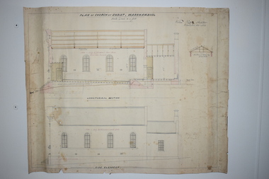
Document, Plan of Church of Christ Warrnambool, 1883
These plans have been drawn up in 1883 by the Warrnambool architect, William Patterson. They show six sections of plans for the erection of a Church of Christ at 12 Spence Street Warrnambool. The mason was William Kellas and the builder was Harold Dawkins. Church of Christ adherents began meeting in Warrnambool in 1875 and bought land in Spence Street in 1877. The church was opened in 1885 with visiting pastors until a resident minister, A. J. Fisher, was appointed in 1915. This church was closed early in the 21st century when a new church, Gateway Church of Christ, was opened in Ragland Parade in Warrnambool. These plans are of great interest as original ones of the Church of Christ In Spence Street Warrnambool. The plans have come from the present-day Warrnambool Church of Christ. The building still exists but is no longer is use as a church. These are two sheets of cream-coloured thick paper with scaled drawings of plan sections of the Church of Christ in Warrnambool. The drawings are in black ink with some sections coloured in. Both pages have a black line margin drawn around the edges. The pages are torn at the edges in several places and the sheets are much stained. The sheets have been reinforced at the back (left side) with thick brown paper.‘Plan of Christ Church Warrnambool’plans church of christ warrnambool, william kellas, harold dawkins warrnambool -
Clunes Museum
Plan - PLANS, NEW NORTH CLUNES MINE - UNDERGROUND WORKINGS
.1 HEADER PAGE: "UNDERGROUND WORKINGS - NEW NORTH CLUNES MINE" .2 PLAN .3 PLAN TRANSVERSE SECTIONS .4 PLAN LONGITUDINALSECTIONS.2 "656" PRINTED ON PLAN (FRONT)" .3 PRINTED ON PLAN R-272/.S/1B .4 R-272/S/1Aunderground workings, new north clunes mine -
 Flagstaff Hill Maritime Museum and Village
Document - Plan, Victorian Harbours Warrnambool, Victorian Harbours, Warrnambool, Plan to Accompany Sir John Coode's Report, 28-02-1879
This plan is of great significance to the local history of Warrnambool, in particular the Breakwater and its impact on Warrnambool's maritime and trade history. The plan shows the existing jetties at the Port of Warrnambool, plus the partially erected Breakwater and proposed works to the Breakwater by both the Borough of Warrnambool Surveyor and Sir John Coode. The plan was signed 28th February 1879 by Sir John Coode. The legend at the bottom left describes the existing works and the proposed works. The Warrnambool Breakwater Sir John Coode was a British harbour engineer. He was brought to Melbourne by the Melbourne Harbour Trust to advise on works to improve the Port of Melbourne. The Victorian Government commissioned him to present a plan to complete the Warrnambool Breakwater. His original plan was too expensive so he prepared a revised plan for a shorter structure. The work was completed in 1890. The construction proved to be too short to protect adequately from the weather and didn't allow enough depth for larger vessels to come into port. The decreasing trade was further affected by siltation in the bay due to the breakwater, and the completion of the railway line. The situation of the harbour became a real problem that, by 1910, required continuous dredging. In 1914 the Breakwater was extended but proved to be a failure because the work began to subside and by 1920 about two thirds of the harbour was silted up. Alterations made in the 1920's increased the silting problem and by the 1940's the harbour was no longer used. More alterations were made in the 1950's and 1960's. The Warrnambool Breakwater is registered as a place of significance on the Victorian Heritage Database. This plan of the proposed works for the existing Warrnambool Breakwater is of great significance to the local history of Warrnambool, in particular the Breakwater and its impact on Warrnambool's maritime and trade history. The Warrnambool Breakwater is registered as a place of significance on the Victorian Heritage Database (VHR H2024). It is historically significant to Victoria as one of the most important maritime engineering projects in Victoria in the late 19th century. The Warrnambool Breakwater is of historical significance as one of the most important maritime engineering projects in Victoria in the late nineteenth century. It is evidence of Victoria's nineteenth century investment in regional port infrastructure and the development of Victorian coastal shipping. It is of significance for its association with the English civil engineer Sir John Coode, the most distinguished harbour engineer of the nineteenth century, who was brought to Victoria to advise on works to improve the Port of Melbourne, but was retained by the Government to advise on improvements to the harbours at Portland, Geelong, Port Fairy, and Lakes Entrance, as well as Warrnambool. His projects for Melbourne, Lakes Entrance and Warrnambool were major engineering projects of the nineteenth century. The breakwater is historically significant as a reminder of Warrnambool's early maritime history as a Western District port, and as one of Victoria's major 'outer ports'. While the Warrnambool Breakwater is a demonstration of the engineering skills of the nineteenth century, it also demonstrates the limitations of knowledge relating to sedimentology at the time and the confidence apparent in a number of nineteenth century plans which assumed that natural forces could be overcome or contained by engineering.Plan of Warrnambool Harbour, Port of Warrnambool, dated 28 Feb 1879. Plan shows existing Breakwater and work proposed by both Warrnambool Borough Surveyor and Sir John Coode. Plan has gold coloured quarter-dowel rods top and bottom and a metal ring at the top. Stamped with title. Signed by Sir John Coode.Stamped "VICTORIAN HARBOURS / WARRNAMBOOL / PLAN / to accompany / SIR JOHN GOODE'S REPORT / DATED 28 FEB 1879" Signature "John Coode"flagstaff hill, warrnambool, maritime museum, shipwreck coast, great ocean road, sir john coode, borough of warrnambool surveyor, plan of warrnambool, victorian harbours, warrnambool harbour, warrnambool breakwater, port of warrnambool, vhd vhr h2024, flagstaff hill maritime museum & village, maritime village, map, chart, plan, lady bay, breakwater, jetty, pier, vhr h2024, proposed works, 1879 -
 Bendigo Military Museum
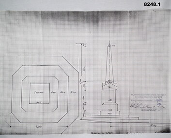
Plan - MONUMENT PLANS, 9.7.1992
All three pertain to the erection of a Monument in front of the Soldiers Memorial Institute in Pall Mall Bendigo to honour Ex Servicemen and Women. Refer Cat No 8245.2.1) Plan, white paper, black print on black graph paper showing front elevation and plan of a monument, signed, dated and stamped. .2) Plan, white paper black print showing plan and section A.A of same structure as .1). .3) Plan, white paper black print showing position of proposed monument as in .1) in front of a building with gardens surrounding. signed, dated and stamped.On all three written and stamped, " Planning and Environment Act 1987 Bendigo Planning scheme - Plan refrred to in Permit No 096/92 - Application No 096 (signature) 9.7.92 - for and on behalf of the responsible authority"brsl, smirsl, plans, monument -
 Bendigo Historical Society Inc.
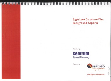
Book - EAGLEHAWK STRUCTURE PLAN BACKGROUND REPORTS, 2011
Eaglehawk Structure Plan Background Reports, 5 reports in 2 volumes identifying a broad range of findings to guide future strategis planning in Eaglehawk, with maps photographs and graphs. Prepared for City of Greater Bendigo: Reports 1 & 2 prepared by Centrum Town Planning (5756a) Reports 3, 4 & 5 prepared by Traffic Works (5756b)Centrum Town Planningbendigo, council, eaglehawk structure plan -
 Kew Historical Society Inc
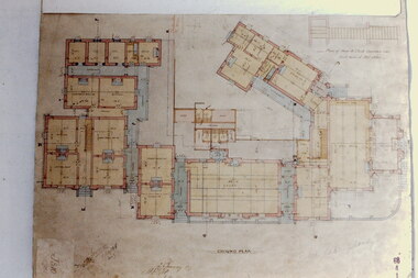
Slide - Architectural Drawing, Kew Public Offices, 1887
A civic campaign for new public offices developed in Kew in the 1880s. After much deliberation, the location chosen was the junction of Bulleen and Cotham Roads. The buildings were designed by George Watson and John Henry Harvey, architects within the Department of Public Works (Victoria). Building was commenced in 1887, and after one year, the buildings were opened. The Post Office was transferred to the new Commonwealth Government in 1901. The Police Station and Court House, sold by the Victorian Government to the City of Boroondara in 2007, are now a community cultural centre and performing arts venue.The buildings were listed on the Victorian Heritage Register Register (HO885) in 1991. They are historically and architecturally significant to the State Of Victoria because Watson and Harvey's designs exhibit diversity in integrating civil offices, they accommodate the apex of road junctions, and they demonstrate a departure from the contemporaneously favoured High Victorian Classical to the Queen Anne style in the design of civic buildings. 35mm colour transparency of an original plan by George Watson and John Henry Harvey, architects of the Department of Public Works (Victoria), in 1887 for New Public Offices at Kew. This plan was copied by the donor from an original held at the Commonwealth Archives in Brighton (Vic). The copy was made to illustrate a report that the donor made on ‘The functional planning design, building materials and construction methods of the Kew Post Office’ as part of course work at RMIT.GROUND PLANkew court house, kew police station, kew post office, architectural drawings, khs - slides, new public offices — kew (vic.), architecture — queen anne style -
Ringwood and District Historical Society
Plans - Freeway, Country Roads Board, Victoria, Eastern Freeway Ringwood Section - Planning Report on Suggested Concepts Investigation (Country Roads Board) 1974, 1974
... Eastern Freeway Ringwood Section - Planning Report on ...Report on suggested concepts investigation for freeway.Report on suggested concepts investigation for freeway. Buff coloured covers with brown printing. Bound with brown Spirex. pp. 39. -
 Bendigo Military Museum
Manual - Digital Topographic Data Compilation Specification - Part 2 Planning Level Products, June 1998
... Planning Level Products ...The purpose of this document is to provide digital Topographic data compilation specifications for the Australian Defence Force (ADF) which are applicable to all areas of the Area of Direct Military Interest (ADMI) for the collection of features and attributes to populate the ADF topographic database.6234.1 A four ringed Folder containing A4 Paper, White, Metal Bindings, Chapters 1 to 8 6234.2 A four ringed Folder containing A4 Paper, White, Metal Bindings, Chapters 8 to 13 and Annexesroyal australian survey corps, rasvy, fortuna, army survey regiment, army svy regt, asr, director of survey - army -
 Eltham District Historical Society Inc
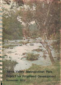
Book, Melbourne Metropolitan Board of Works, Yarra Valley Metropolitan Park : report for proposed development : a recreation, conservation and landscape planning study for the Melbourne and Metropolitan Board of Works, Metropolitan Parks Division / by Scott and Furphy Engineers Pty Ltd, Landscape Division, November 1979
... development : a recreation, conservation and landscape planning study ...melbourne metropolitan board of works, yarra river, yarra river valley, yarra valley metropolitan park -
 Eltham District Historical Society Inc
Letter, Letter from Joh Ebeli to Peter Bassett-Smith regarding 1979 Eltham festival and planning for 1980, 14 August 1979, 1979
... Eltham festival and planning for 1980, 14 August 1979 ...Proposal for horse drawn vehicles at the 1980 parade and expression of thanks to the people who assisted in the 1979 float; Geoffrey Loftus Hills, Mark Gough. And ideas of drumming up greater members, possible partnerships with Nillumbik Historical SocietySingle page, typed on Ebeli and Associates letterhead1979, 1980, eltham festival, geoffrey loftus hills, joh ebeli, mark gough, nillumbik historical society, opal smith, peter bassett-smith, rie ebeli, victorian folk music club -
 Eltham District Historical Society Inc
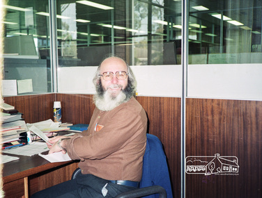
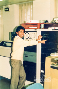
Photograph, Staff member, Shire of Eltham Planning Department, c.July 1991, 1991
... Staff member, Shire of Eltham Planning Department, c.July ...Roll of 35mm colour negative film, 4 stripsFuji 100 -
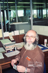 Eltham District Historical Society Inc
Photograph, Staff member, Shire of Eltham Planning Department, c.July 1991, 1991
... Staff member, Shire of Eltham Planning Department, c.July ...Roll of 35mm colour negative film, 4 stripsFuji 100 -
 Eltham District Historical Society Inc
Photograph, Staff member, Shire of Eltham Planning Department, c.July 1991, 1991
... Staff member, Shire of Eltham Planning Department, c.July ...Roll of 35mm colour negative film, 4 stripsFuji 100 -
Federation University Historical Collection
Document, Part of a report into disaster planning
... Part of a report into disaster planning ... -
 Federation University Historical Collection
Photograph - Photograph - black and whit, VIOSH: Planning session for VIOSH courses at Mount Helen Campus, c2000
... VIOSH: Planning session for VIOSH courses at Mount Helen ...Victorian Institute of Occupational Safety and Health (VIOSH) Australia is the Asia-Pacific centre for teaching and research in occupational health and safety (OHS) and is known as one of Australia's leaders on the field. VIOSH has a global reputation for its innovative approach within the field of OHS management. Federation University VIOSH Australia students are safety managers, senior advisors and experienced OHS professionals. They come from all over Australia and industry. Students are taught active research and enquiry; rather than textbook learning and a one-size fits all approach. VIOSH accepts people into the Graduate Diploma of Occupational Hazard Management who have no undergraduate degree - on the basis of extensive work experience and knowledge. Lecturers were from the university staff and visiting staff from industry and consulting groups. Black and white photographs showing VIOSH personnel. viosh, victorian institute of safety and health, australia, asia-pacific, teaching and research, university of ballarat, federation university, derek woolley, dennis else, prof p compes, prof r vernon -
Federation University Historical Collection
Photograph, Photographs of the planning for the Arbotoreum
... Photographs of the planning for the Arbotoreum ...Mt Helen Campus is the site of Federation University. A trail travels through the Arboretum where you may see resting kangaroos and wallabies, crosses a creek that holds a vulnerable colony of frogs commonly known as Victorian Smooth Froglet (Geocrinia victoriana), and admire the grass trees (Xanthorrhea australis) that grow on the campus behind accommodation.Two coloured photographs of Rob McClellan, David James and Martin Westbrooke at the launch of the arbotoruem at Federation University.1 David James - Vice Chancellor, Rob McLellan - Minister, Martin Westbrooke - Science/Eng.2 Rob McLellan abotoreum, mt helen campus aboretium, mt helen campus, federation university, david james, rob mclellan, martin westbrooke -
Phillip Island and District Historical Society Inc.
Book, SEDDON, George, Phillip Island : capability, conflict and compromise : a report to the Western Port Regional Planning Authority, 1975
... report to the Western Port Regional Planning Authority ...Stamped 'Phillip Island & District Historical Society'.regional planning, victoria, phillip island -
Phillip Island and District Historical Society Inc.
Book, SEDDON, George, Phillip Island : capability, conflict and compromise : a report to the Western Port Regional Planning Authority, 1975
... report to the Western Port Regional Planning Authority ...regional planning, victoria, phillip island -
 Eltham District Historical Society Inc
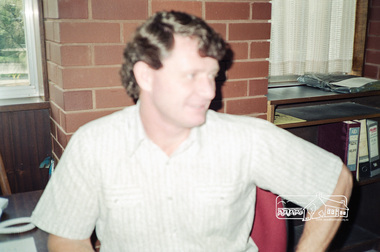
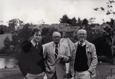
Photograph, Earl Roberts, Planning Department, Shire of Eltham, 1985, 1985
... Earl Roberts, Planning Department, Shire of Eltham, 1985 ...Shire of Eltham Archives Series 13, Photograph Album, 1985. Originally contained in a 2-ring PVC binder and document sleevesTwo colour photographsseries 13, shire of eltham archives, shire of eltham, earl roberts -
 Eltham District Historical Society Inc
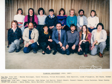
Photograph, Staff Photo, Planning Department, Shire of Eltham, July, 1987 (with names), 1987
... Staff Photo, Planning Department, Shire of Eltham, July ...Top Row, from left - Monika Roitinger, Carol Christie, Vivian Williamson, Anne Spurritt, Linda O'Laughlin, Dot Boyne, Graham Wilkie, Anne Rohan. Bottom Row, from left - Roger Collins, John Galea, Lyn Harris, Robert Abnett, Russell Yeoman, Julie Coulston, Peter Conroy. (Staff not present - Denis McKay, Garry Bartlett, Catherine Bickley).Two colour photographs, laminated, with typed list of names 2 copies different sizes 22.5 x 27 cm laminated (12.5 x 20 cm photo) and 26.5 x 33 cm laminated (19 x 25.5 cm photo)shire of eltham, council staff -
 Kiewa Valley Historical Society
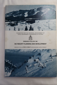
Book - Ski Resort Planning and Development, Ski Resort Planning and Development by Research Fellow Ron G. Sibley Shire Engineer, Shire of Bright
... Ski Resort Planning and Development by Research Fellow Ron ...This book was published in 1981 when the Ski Industry and the Shire of Bright were proposing to expand the tourism industry.Of interest to Local Government and to those involved in the development of and activities carried out in Alpine country and ski resort areas. This research identifies the advantages and possibilities for the future.Hard light blue plain cover book with paper cover and bound spine. The paper cover has a snow photo (bluish) above and below the title. 113 pages with black and white photos and diagrams.Front page has "B.H.Goss / 37 Roper St., / Mt. Beauty 3699" stamped in top right corner.ski resort planning, ski resort development, falls creek's future, shire of bright