Showing 821 items matching "plenty river"
-
 Greensborough Historical Society
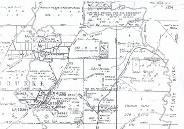
Maps, Greensborough west of Plenty River, 1840o
... Greensborough west of Plenty River...Areas of Greensborough, west of the Plenty River, showing... of the Plenty River, showing land holdings in the 1840s. Comprises ...Areas of Greensborough, west of the Plenty River, showing land holdings in the 1840s. Comprises Sections 8, 9, 10, 14, 15, 16, 17, 18, 19, 20 Parish of KeelbundoraOne A4 photocopy, one A3 enlargementgreensborough, watsonia, lower plenty, janefield -
 Greensborough Historical Society
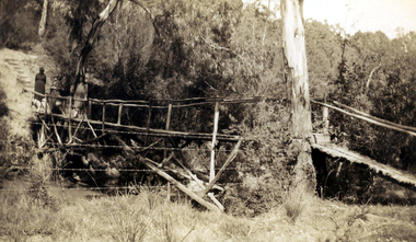
Photograph - Digital image, Rose McLaughlin and others - bridge over Plenty River 1935, 1935_
... Rose McLaughlin and others - bridge over Plenty River 1935....) Myrtle McLaughlin - Bridge over Plenty River 1935. John.... Rose McLaughlin and others - bridge over Plenty River 1935 ...Rose McLaughlin, Frank Oxley (Cousin of John McLaughlin) Myrtle McLaughlin - Bridge over Plenty River 1935. John McLaughlin and Rosalie Ellen Whatmough came to Greensborough in 1840 from Belfast. These photographs from the collection of Myrtle McLaughlin show friends and relatives from the Greensborough and Plenty area.This photograph shows some of the primitive conditions in the area.Digital copy of black and white photograph.myrtle mclaughlin, rosalie mclaughlin, frank oxley -
 Eltham District Historical Society Inc
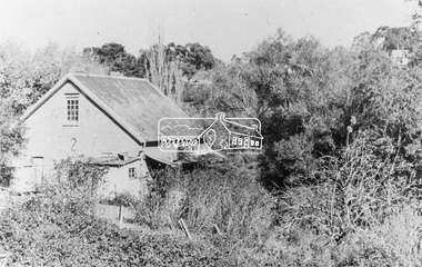
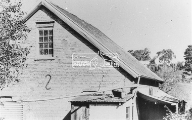
Photograph, Willis Vale on the north bank of the Plenty River, Church Street, Greensborough, c.1950
... Willis Vale on the north bank of the Plenty River, Church... on the north bank of the Plenty River at the end of Church Street..., situated on the north bank of the Plenty River at the end of Church ...Photo sourced from Heidelberg Historical Society reproduced on p63 of The Diamond Valley Story by Dianne H. Edwards, Shire of Diamond Valley 1979. "Willis Vale, Greensborough, situated on the north bank of the Plenty River at the end of Church Street. The home wasa built about 1840 by Jame Willis Mayger from bricks hand-made nearby. It was later passed to the Partington family and when this photo was taken the building was deserted. Vandals and finally a bushfire destroyed Willis Vale in the 1950s." Greensborough Historical Society has same image with more accurate information on the date/cause of fire damage https://victoriancollections.net.au/items/585b6c96d0ce2c1268f1c96b "House built by Edward Maygar, Robert Whatmough lived there mid 19th century and later sold to Partington family. It was located on the Plenty River at Partington's Flat Greensborough. The derelict Willis Vale house was destroyed in 1964 when a fire originating from North Plenty Gorge - Kurrak Road - was lit by two teenage boys and made its way several kilometres down to Partington's Flat Greensborough."Black and white copy of photo printed on glossy photographic paper 30.5 x 40.5 cm (12 x 16 inch); image size approx. 18.5 x 28 cmchurch street, diamond valley story, greensborough, james willis mayger, partington family, willis vale -
 Eltham District Historical Society Inc
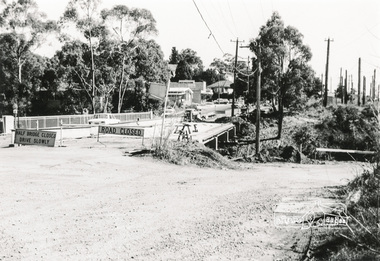
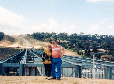
Photograph, Looking south onto the Plenty River Trail Reserve from the new bridge ove the Plenty River; Greensborough Bypass construction, c.1986, 1986c
... Looking south onto the Plenty River Trail Reserve from the... photosafe storage. Looking south onto the Plenty River Trail Reserve ...Colour photograph originally located in a magnetic style album titled 'Greensborough Bypass 1990s 5' suffering significant degradation. No information contained in album or on reverse of photos except where noted. Relocated to archival photosafe storage.greensborough bypass, road construction, greensborough, greensborough plaza -
 Greensborough Historical Society
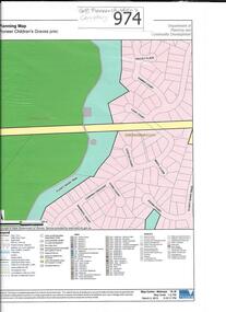
Map, Pioneer children's graves precinct, 1848-1860
... Children's Cemetery on the Plenty River in Greensborough. Children...Printed coloured copy of map of Plenty River area... and surrounds of Pioneer Children's Cemetery on the Plenty River ...Map showing the location and surrounds of Pioneer Children's Cemetery on the Plenty River in Greensborough. Children from pioneer families are buried here.Official government planning map for the Pioneer Children's Graves Precinct.Printed coloured copy of map of Plenty River areapioneer childrens cemetery, greensborough, partington, whatmough -
 Greensborough Historical Society
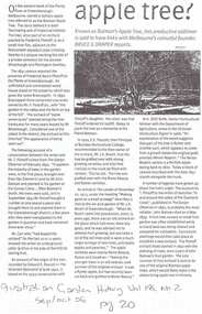
Article, Batman Apple Tree, 11/12/2002
... plenty river... of the Plenty River, north of Greensborough.... flintoff plenty river 1841 rome beauty rymer apples winter majetin ...Details some versions of the history of the 'Batman Apple Tree'. Also the condition and lack of maintenance of the tree in 2002. Highlights Nillumbik Shire's ignorance of the existence of the tree; which is within one kilometre of the Nillumbik Shire Offices.It is possibly the oldest European planted tree in Victoria. It was planted as a young tree in 1841.A4 photocopies of 3 articles relating to the condition and origin of the "Batman Apple Tree", located on the eastern bank of the Plenty River, north of Greensborough.Blue pen annotations on one article.apples, john batman, robert whatmough, frederick nevin flintoff, plenty river, 1841, rome beauty, rymer apples, winter majetin, apollo parkways primary school -
 Eltham District Historical Society Inc
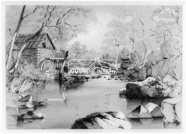
Photograph, George Alexander Gilbert 1815-1877, Anderson's Mill on the River Plenty, 1849
... Anderson's Mill on the River Plenty...plenty river... areas plenty river anderson's mill Digital image Anderson's Mill ...This photo forms part of a collection of photographs gathered by the Shire of Eltham for their centenary project book,"Pioneers and Painters: 100 years of the Shire of Eltham" by Alan Marshall (1971). The collection of over 500 images is held in partnership between Eltham District Historical Society and Yarra Plenty Regional Library (Eltham Library) and is now formally known as the 'The Shire of Eltham Pioneers Photograph Collection.' It is significant in being the first community sourced collection representing the places and people of the Shire's first one hundred years.Digital imageshire of eltham pioneers photograph collection, other areas, plenty river, anderson's mill -
 Eltham District Historical Society Inc
Photograph, Para Road Bridge construction, Briar Hill, near Greensborough, c.1971, 1971c
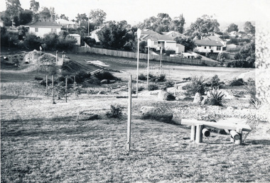
... plenty river... works of the bridge over the Plenty River at Briar Hill and one... plenty river Three black and white photographs; two showing ...Three black and white photographs; two showing construction works of the bridge over the Plenty River at Briar Hill and one of Greensborough Park, Grimshaw Street, summer 1971-1972greensborough, briar hill, para road, bridges, construction, plenty river -
 Eltham District Historical Society Inc
Photograph, Para Road Bridge construction, Briar Hill, near Greensborough, c.1971, 1971c
... plenty river... works of the bridge over the Plenty River at Briar Hill and one... plenty river Three black and white photographs; two showing ...Three black and white photographs; two showing construction works of the bridge over the Plenty River at Briar Hill and one of Greensborough Park, Grimshaw Street, summer 1971-1972greensborough, briar hill, para road, bridges, construction, plenty river -
 Greensborough Historical Society
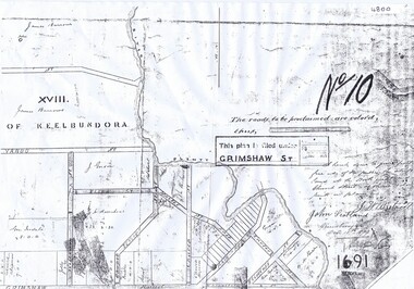
Plan, Parish Plan Map of Land North of Grimshaw Street, 11/12/1879
... bounded by the Plenty River. Includes annotation signed by John... Street bounded by the Plenty River. ... of Grimshaw Street bounded by the Plenty River. Includes annotation ...Part of Parish plan of land north of Grimshaw Street bounded by the Plenty River. Includes annotation signed by John Scotland and J. W. Britnell, dated Dec. 11th 1879.Photocopy of part of Parish plan of land north of Grimshaw Street bounded by the Plenty River. Includes annotation signed by John Scotland and J. W. Britnell, dated Dec. 11th 1879greensborough, grimshaw street greensborough, jonah britnell, john scotland -
 Eltham District Historical Society Inc
Photograph - Digital Photograph, Alan King, Maroondah Aqueduct Siphon Bridge over the Plenty River, 26 January 2008
... Maroondah Aqueduct Siphon Bridge over the Plenty River..., the siphon bridge spanning the Plenty River off Leischa Court..., the siphon bridge spanning the Plenty River off Leischa Court ...Opened in 1891, the bridge formed part of the Maroondah Aqueduct carrying water from Watts River near Healesville to the reservoir at Preston where it joined Melbourne's metropolitan water system. Covered under Heritage Overlay, Nillumbik Planning Scheme. Published: Nillumbik Now and Then / Marguerite Marshall 2008; photographs Alan King with Marguerite Marshall.; p99 Built to supply thirsty Melbourne in the late 19th century, the siphon bridge spanning the Plenty River off Leischa Court, Greensborough, was part of an engineering masterpiece. Opened in 1891, the bridge formed part of the Maroondah Aqueduct carrying water from the Watts River near Healesville to the reservoir at Preston where it joined the metropolitan distribution system. A major link in Melbourne’s water supply, it also had a huge impact on communities, which mushroomed along its route. Named after the Aboriginal word for the area around the Maroondah Reservoir, the Maroondah Aqueduct was fully operational until the 1970s. Since the 1980s the land along parts of the aqueduct have been used for walking and bicycle riding, shaded in places by Monterey Pine trees planted to stabilise the surrounding ground. From 1857 the Yan Yean Reservoir supplied Melbourne’s water but the growing city needed additional catchments.1 In 1886 work began on a weir on the Watts River to enable the aqueduct to carry most of the river water 41 miles (66km) to Melbourne. The aqueduct, built by the Board of Works, is the oldest remaining aqueduct near Melbourne and was probably the first built with concrete.2 Although the aqueduct is now only used between the Maroondah and Sugarloaf Reservoirs, it can still be traced across the Shire. It extends from the Maroondah Reservoir through Christmas Hills, Kangaroo Ground, Research, Eltham, St Helena and then previously wound west through Greensborough to Reservoir.3 Built by horse and manpower the aqueduct gravity fed 25 million gallons (113.6ML) of water a day to Melbourne along a gradient of one foot to the mile. It included 25 miles (41km) of open concrete and brick channel, six miles (10km) of tunnels, and nine miles (15km) of 14 inverted siphons of riveted wrought-iron across creeks. Bricks for the aqueduct were made from clay found near the sites and remains of several kilns can still be found between Kangaroo Ground and Christmas Hills. Building the aqueduct transformed local communities. An abattoir was established at Christmas Hills. Grog shanties and labourers’ camps sprang up and local courts dealt with cases of ‘petty pilfering and boisterous behaviour’.4 The Kangaroo Ground school population jumped to 91, crammed into a room with one teacher. Miners who built the tunnels camped just north of Churinga in Greensborough – then called Tunnel Hill Camp – and adjacent to the Evelyn Arms Hotel. The miners’ high spirits were sometimes quenched in horse troughs or by a ‘welt under the ear and kick on the behind’ as the local constable calmed them down rather than lock them up.5 But the growing city of Melbourne needed more water, so the O’Shannassy catchment, east of Warburton, was added to the system in 1914. In 1920 work began on the present concrete Maroondah Dam one mile (1.6km) from the weir on the Watts River. The aqueduct capacity was thus doubled to 50 million gallons (227ML) a day.6 Intense land development threatened to pollute the open water supply, so channel sections were replaced with large pipes. In the late 1960s a large water main was built from the tunnel outlet at Research and extended through St Helena and Greensborough, so this section of the aqueduct was taken out of use. Long sections of the unused open channels in Greensborough and Bundoora were destroyed, but the old channel in Research and Eltham North remained largely intact. In the 1970s, the Sugarloaf Reservoir was constructed, inundating 445 hectares of land in Christmas Hills. Sugarloaf was officially opened in 1980 and serves as a water storage and treatment plant supplying Melbourne. In the early 1980s pipes replaced the section from Sugarloaf Reservoir to the tunnel entrance at Kangaroo Ground. The Research-Kangaroo Ground tunnel operates as part of the pipeline system.This collection of almost 130 photos about places and people within the Shire of Nillumbik, an urban and rural municipality in Melbourne's north, contributes to an understanding of the history of the Shire. Published in 2008 immediately prior to the Black Saturday bushfires of February 7, 2009, it documents sites that were impacted, and in some cases destroyed by the fires. It includes photographs taken especially for the publication, creating a unique time capsule representing the Shire in the early 21st century. It remains the most recent comprehenesive publication devoted to the Shire's history connecting local residents to the past. nillumbik now and then (marshall-king) collection, maroondah aqueduct, pipe bridge, siphon bridge -
 Greensborough Historical Society
Folder, Ann Douglas, Greenbelts, 1973_
... plenty river... River, and its cleanup by the Plenty River Action Committee... of the condition of the Plenty River, and its cleanup by the Plenty River ...Includes much information of the condition of the Plenty River, and its cleanup by the Plenty River Action Committee, a group of students at Watsonia Technical School. Includes interview on audio tape which have been transcribed.Looseleaf folder containing handwritten report, miscellaneous documents, col. photographs and 2 audiotapes (see Word doc for transcript of audio tapes)plenty river, plenty river action committee, david wilkinson -
 Greensborough Historical Society
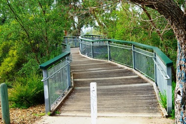
Photograph - Digital image, Marilyn Smith, Partington's Flat: footbridge over the River, 16/08/2015
... plenty river trail... the river on the Plenty River Trail.... the footbridge over the river on the Plenty River Trail. partingtons flat ...Partington's Flat. This photo shows the footbridge over the river on the Plenty River Trail.Digital copy of colour photographspartingtons flat, plenty river trail, plenty river -
 Eltham District Historical Society Inc
Document - Property Binder, Plenty River Bridge, Main Road, Lower Plenty
... Plenty River Bridge, Main Road, Lower Plenty..., photocopies, etc held on the subject property. Plenty River Bridge ...Extracts Heidelberg Council Minutes re Plenty Bridge, 3 September1862, 10 May 1865, 22 May 1865, 5 June 1865 , 10 October1866, 14 November1866, 13 February 1867.main road, property, houses, shops, businesses, plenty bridge -
 Eltham District Historical Society Inc
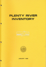
Book, Melbourne and Metropolitan Board of Works, Plenty River Inventory, 1986
... Plenty River Inventory...-ring A3 PVC folder Plenty River Inventory Book Book Melbourne ...The Melbourne and metropolitan Board of Works provided the lead agency role for implementing the Urban Waterways Program announced by the Victorian Government in February 1985. -
 Eltham District Historical Society Inc
Photograph, Willis Vale on the north bank of the Plenty River, Church Street, Greensborough, c.1950
... Willis Vale on the north bank of the Plenty River, Church... of the Plenty River, Church Street, Greensborough, c.1950 Photograph ...Photo probably sourced from Heidelberg Historical Society, Similar photo reproduced on p63 of The Diamond Valley Story by Dianne H. Edwards, Shire of Diamond Valley 1979. Black and white copy of photo printed on glossy photographic paper 30.5 x 40.5 cm (12 x 16 inch); image size approx. 18.5 x 28 cmchurch street, diamond valley story, greensborough, james willis mayger, partington family, willis vale -
 Greensborough Historical Society
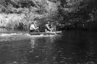
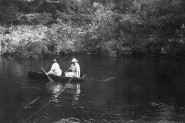
Photograph - Digital image, Two men canoeing on the Plenty River in 1937, 1937_
... Two men canoeing on the Plenty River in 1937.... photograph. Two men canoeing on the Plenty River in 1937. Photograph ...Part of a collection of photographs owned by Dorris McLaughlin who was born in Greensborough, in 1899 to John McLaughlin and Rosalie Ellen Whatmough. The collection contains photographs of friends and relatives from the Greensborough and Eltham areas. This photograph shows two men canoeing on the river.Digital copy of black and white photograph.dorris mclaughlin -
 Greensborough Historical Society
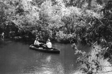
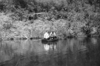
Photograph - Digital image, Two men in fishing boat on the Plenty River in 1937, 1937_
... Two men in fishing boat on the Plenty River in 1937.... on the Plenty River in 1937. Photograph - Digital image ...Part of a collection of photographs owned by Dorris McLaughlin who was born in Greensborough, in 1899 to John McLaughlin and Rosalie Ellen Whatmough. The collection contains photographs of friends and relatives from the Greensborough and Eltham areas. This photograph shows two men fishing from a boat on the river.Digital copy of black and white photograph.dorris mclaughlin -
 Greensborough Historical Society
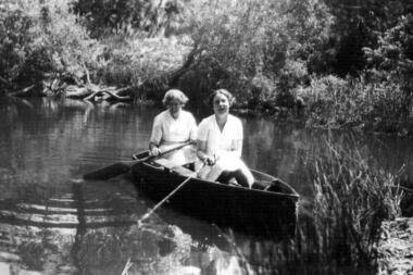
Photograph - Digital image, Couple canoeing on the Plenty River in 1937, 1937_
... Couple canoeing on the Plenty River in 1937..... Couple canoeing on the Plenty River in 1937. Photograph - Digital ...Part of a collection of photographs owned by Dorris McLaughlin who was born in Greensborough, in 1899 to John McLaughlin and Rosalie Ellen Whatmough. The collection contains photographs of friends and relatives from the Greensborough and Eltham areas. This photograph shows a man and woman canoeing on the river.Digital copy of black and white photograph. -
 Greensborough Historical Society
Photograph - Digital image, Canoeing on Plenty River in 1937, 1937_
... Canoeing on Plenty River in 1937... photograph. Canoeing on Plenty River in 1937 Photograph - Digital ...Part of a collection of photographs owned by Dorris McLaughlin who was born in Greensborough, in 1899 to John McLaughlin and Rosalie Ellen Whatmough. The collection contains photographs of friends and relatives from the Greensborough and Eltham areas. This photograph shows two women canoeing on the river.Digital copy of black and white photograph.dorris mclaughlin -
 Greensborough Historical Society
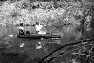
Photograph - Digital image, Two men in a boat fishing on the bank of the Plenty River in 1937, 1937_
... Two men in a boat fishing on the bank of the Plenty River... of the Plenty River in 1937. Photograph - Digital image ...Part of a collection of photographs owned by Dorris McLaughlin who was born in Greensborough, in 1899 to John McLaughlin and Rosalie Ellen Whatmough. The collection contains photographs of friends and relatives from the Greensborough and Eltham areas. This photograph shows two men fishing from a boat on a river.Digital copy of black and white photograph.dorris mclaughlin -
 Greensborough Historical Society
Photograph - Digital image, Two women boating on the Plenty River in 1937, 1937_
... Two women boating on the Plenty River in 1937.... photograph. Two women boating on the Plenty River in 1937. Photograph ...Part of a collection of photographs owned by Dorris McLaughlin who was born in Greensborough, in 1899 to John McLaughlin and Rosalie Ellen Whatmough. The collection contains photographs of friends and relatives from the Greensborough and Eltham areas. This photograph shows two women canoeing on a river.Digital copy of black and white photograph.dorris mclaughlin -
 Greensborough Historical Society
Folder of Documents, Anne Paul, Plenty River Heritage sites / Anne Paul, 1937_
... Plenty River Heritage sites / Anne Paul... Plenty Lower Plenty melbourne This collection of correspondence ...This collection of correspondence, articles and photographs was collected by GHS member Anne Paul in support of Heritage overlays for the Pioneer Children's Graves, Batman Apple Tree and Maroondah Aqueduct.Blue plastic folder containing a large number of documents and images.anne paul, pioneer childrens cemetery, batman apple tree, maroondah aqueduct -
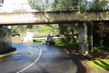
 Greensborough Historical Society
Photograph - Digital image, Marilyn Smith, Railway Road Rail Bridge over Plenty River Briar Hill, 17/09/2014
... Railway Road Rail Bridge over Plenty River Briar Hill... over Plenty River Briar Hill Photograph - Digital image Marilyn ...Rail bridge over Railway Road Greensborough, near Para Road.Digital copy of colour photographrailway road greensborough, para road greensborough -
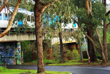
 Greensborough Historical Society
Photograph - Digital image, Marilyn Smith, Railway Road Rail Bridge over Plenty River Briar Hill, 17/09/2014
... Railway Road Rail Bridge over Plenty River Briar Hill... Bridge over Plenty River Briar Hill Photograph - Digital image ...Rail bridge over Railway Road Greensborough.Digital copy of colour photograph -
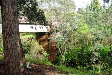
 Greensborough Historical Society
Photograph - Digital image, Marilyn Smith, Railway Road Rail Bridge over Plenty River Briar Hill, 17/09/2014
... Railway Road Rail Bridge over Plenty River Briar Hill... photograph Railway Road Rail Bridge over Plenty River Briar Hill ...Rail bridge over Railway Road Greensborough.Digital copy of colour photographrailway road greensborough -
 Greensborough Historical Society
Photograph - Digital image, Marilyn Smith, Railway Road Rail Bridge over Plenty River Briar Hill, 17/09/2014
... Railway Road Rail Bridge over Plenty River Briar Hill... Plenty Lower Plenty melbourne Para Road near Railway Road ...Para Road near Railway Road Greensborough Digital copy of colour photographrailway road greensborough, para road greensborough -
 Eltham District Historical Society Inc
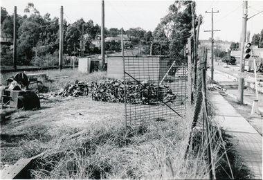
Photograph, Bridge construction over the Plenty River; Greensborough Bypass construction, c.1986, 1986c
... Bridge construction over the Plenty River; Greensborough... photosafe storage. Bridge construction over the Plenty River ...Colour photograph originally located in a magnetic style album titled 'Greensborough Bypass 1990s 5' suffering significant degradation. No information contained in album or on reverse of photos except where noted. Relocated to archival photosafe storage.greensborough bypass, road construction, greensborough, bridge construction -
 Eltham District Historical Society Inc
Photograph, Looking east across the new bridge construction across the Plenty River from the western side up to the new roundabout at Civic Drive; Greensborough Bypass construction, c.1986, 1986c
... Plenty River from the western side up to the new roundabout at... across the Plenty River from the western side up to the new ...Colour photograph originally located in a magnetic style album titled 'Greensborough Bypass 1990s 5' suffering significant degradation. No information contained in album or on reverse of photos except where noted. Relocated to archival photosafe storage.greensborough bypass, road construction, greensborough, bridge construction