Showing 1148 items matching "price collection"
-
 Bendigo Historical Society Inc.
Document - H.A. & S.R. WILKINSON COLLECTION: CONDITION OF SALE
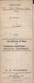
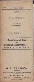
Conditions of sale by private contract dated 10th February, 1930 between T. Watson (seller) and R. Rigby (buyer) for land situate corner Milroy and Harrison Streets, Bendigo, being Crown allotment 405 section K described in Crown grant volume 1345 folio 268824, together with all buildings on said property. Price 650 pounds.organization, business, h.a. & s.r wilkinson real estate -
 Bendigo Historical Society Inc.
Document - H.A. & S.R. WILKINSON COLLECTION: CONDITION OF SALE
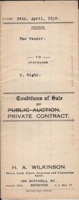
Conditions of sale by private contract dated 24th April 1930 between H.A. Wilkinson (seller) and R. Rigby (buyer) for land situate Vinton Street, California Gully being such parts as lie above the depth of fifty feet below the surface and being Crown allotment 589 section M borough of Eaglehawk described in Crown grant volume 3293 folio 658581, together with weatherboard dwelling and all sundry. Price 85 pounds.organization, business, h.a. & s.r wilkinson real estate -
 Bendigo Historical Society Inc.
Document - H.A. & S.R. WILKINSON COLLECTION: CONDITION OF SALE
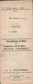
Conditions of sale by private contract dated 24th April 1930 between H.A. Wilkinson (seller) and R. Rigby (buyer) for land situate Vinton Street, California Gully being such parts as lie above the depth of fifty feet below the surface and being Crown allotment 589 section M borough of Eaglehawk described in Crown grant volume 3293 folio 658581, together with weatherboard dwelling and all sundry. Price 85 pounds.organization, business, h.a. & s.r wilkinson real estate -
 Bendigo Historical Society Inc.
Document - H.A. & S.R. WILKINSON COLLECTION: CONDITION OF SALE
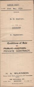
Conditions of sale by private contract dated 22nd May, 1930 between D.K Doxford (seller) and G. Rasmussen (buyer) for land situate in Charles Street, Bendigo, together with 5-roomed weatherboard dwelling and all sundry. Price 440 pounds.organization, business, h.a. & s.r wilkinson real estate -
 Bendigo Historical Society Inc.
Document - H.A. & S.R. WILKINSON COLLECTION: CONDITION OF SALE
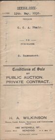
Conditions of sale by private contract dated 12th May, 1930 between C.C.A. Phair (seller) and G. Rasmussen (buyer) for land situate in Long Gully, together with 4-roomed weatherboard dwelling and all sundry. Price 225 poundsorganization, business, h.a. & s.r wilkinson real estate -
 Bendigo Historical Society Inc.
Document - H.A. & S.R. WILKINSON COLLECTION: CONTRACT OF SALE
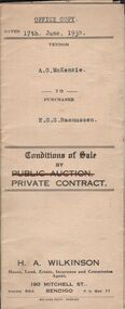
Conditions of sale by private contract dated 17th June, 1930 between A.G. McKenzie (seller) and E.G.S. Rasmussen (buyer) for land situate Havlin Street, Bendigo adjoining Mr. J. Bennett's property and occupied by Mr.. Price as tenant, being part of Crown allotments 392 and 393 section 8 described in certificate of title volume 5514 folio 1102695, together with 5-roomed weatherboard dwelling and all sundry. Price 775 poundsorganization, business, h.a. & s.r wilkinson real estate -
 Bendigo Historical Society Inc.
Document - H.A. & S.R. WILKINSON COLLECTION: CONDITION OF SALE
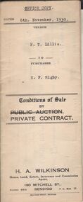
Conditions of sale by private contract dated 6th November, 1930 between F.T. Lillie (seller) and E.F. Rigby (buyer) for land situate corner Casley and Rae Streets, Long Gully together with 6-roomed weatherboard dwelling and all sundry. Price 200 pounds.organization, business, h.a. & s.r wilkinson real estate -
 Bendigo Historical Society Inc.
Document - H.A. & S.R. WILKINSON COLLECTION: CONTRACT OF SALE
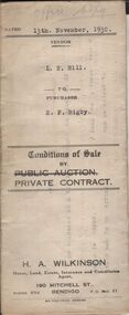
Conditions of sale by private contract dated 13th November, 1930 between L.E. Hill (seller) and E.F. Rigby (buyer) for all those goods and chattels enumerated in schedule on page 2 of this contract, and at present in premises in Hargreaves Street, Bendigo and used by the vendor in connection with the business of fruiterer and confectioner carried on at the above address. Price 60 pounds.organization, business, h.a. & s.r wilkinson real estate -
 Bendigo Historical Society Inc.
Document - H.A. & S.R. WILKINSON COLLECTION: CONDITION OF SALE
Conditions of sale by private contract dated 12th May, 1932 between H.A. Wilkinson (seller) and S. Rigby (buyer) for land within the special settlement area situate Junortoun containing 17 acres, 1 rood, 27 perches being allotment 37F Parish of Wellsford, County of Bendigo described in Crown grant volume 4485 folio 896958, together with 4-roomed weatherboard dwelling and all sundry. Price 575 pounds.organization, business, h.a. & s.r wilkinson real estate -
 Bendigo Historical Society Inc.
Document - H.A. & S.R. WILKINSON COLLECTION: CONDITION OF SALE
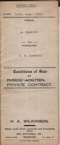
Conditions of sale by private contract dated 12th August, 1932 between A. Cameron (seller) and E.H. Reddick (buyer) for land being allotment 59 section 29A certificate of title volume 3357 folio 671265. Price 430 pounds.organization, business, h.a. & s.r wilkinson real estate -
 Bendigo Historical Society Inc.
Document - H.A. & S.R. WILKINSON COLLECTION: CONDITION OF SALE
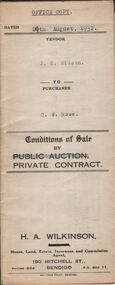
Conditions of sale by private contract dated 29th August, 1932 between J.S. Wilson (seller) and C.W. Rowe (buyer) for land situate No. 91 Booth Street, Golden Square, at present occupied by Mr. Greenway as tenant, being the land described in certificate of registration as residence area No. ? Together with 5 roomed weatherboard dwelling and all sundry. Price 260 pounds.organization, business, h.a. & s.r wilkinson real estate -
 Bendigo Historical Society Inc.
Document - H.A. & S.R. WILKINSON COLLECTION: CONTRACT OF SALE
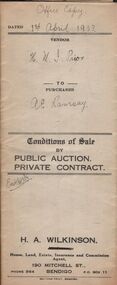
Conditions of sale by private contract dated 1st April, 1933 between H.M.I. Prior (seller) and A.E. Ramsay (buyer) for land situate Brown Street, Eaglehawk, being land described in certificate of registration as residence area No. 3916, together with 4-roomed weatherboard dwelling and all sundry. Price 150 pounds.organization, business, h.a. & s.r wilkinson real estate -
 Bendigo Historical Society Inc.
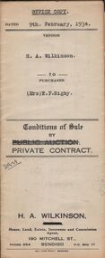
Document - H.A. & S.R. WILKINSON COLLECTION: CONTRACT OF SALE
Conditions of sale by private contract dated 9th February, 1934 between H.A. Wilkinson (seller) and Mrs. E.F. Rigby (buyer) for land situate Creek Street, Bendigo described in certificates of title volume 2776 folio 555075 and volume 5725 folio 1144852. Also all the vendor's right title and interest in and to that portion of land facing Clarke Street as fenced and adjoining above mentioned land, together with 5-roomed weatherboard dwelling and all sundry. Price 350 pounds.organization, business, h.a. & s.r wilkinson real estate -
 Bendigo Historical Society Inc.
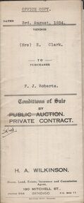
Document - H.A. & S.R. WILKINSON COLLECTION: CONTRACT OF SALE
Conditions of sale by private contract dated 3rd August, 1934 between Mrs, E. Clark (seller) and F.J. Roberts (buyer) for land situate No. 7 Cobden Street, Bendigo at present occupied by Mrs. Fallon as tenant, being part of Crown allotment 7 and 8 section 65C described in certificate of title volume 4710 folio 941957, together with 6-roomed weatherboard dwelling and all sundry. Price 450 poundsorganization, business, h.a. & s.r wilkinson real estate -
 Bendigo Historical Society Inc.
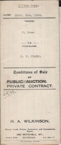
Document - H.A. & S.R. WILKINSON COLLECTION: CONTRACT OF SALE
Conditions of sale by private contract dated 26th November, 1934 between F. Rose (seller) and E.F. Rigby (buyer) of all that fruit and confectionary business situate No. 187 Mitchell Street, Bendigo, comprising all the stock, fittings, counters, show-cases within said shop, together with gas stove in kitchen and everything within the refreshment room with the exception of four pictures, one clock and one piano. Price 120 poundsorganization, business, h.a. & s.r wilkinson real estate -
 Bendigo Historical Society Inc.
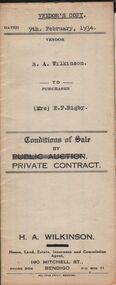
Document - H.A. & S.R. WILKINSON COLLECTION: CONTRACT OF SALE
Conditions of sale by private contract dated 9th February, 1934 between H.A. Wilkinson (seller) and Mrs. E.F. Rigby (buyer) for land situate Creek Street, Bendigo land being described in certificates of title volume 2776 folio 555075 and volume 5725 folio 1144851. Also all the vendor's right title and interest in and to that portion of land facing Clarke Street as fenced, and adjoining above mentioned land, together with 5-roomed weatherboard dwelling and all sundry. Price 350 pounds.organization, business, h.a. & s.r wilkinson real estate -
 Bendigo Historical Society Inc.
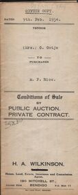
Document - H.A. & S.R. WILKINSON COLLECTION: CONTRACT OF SALE
Conditions of sale by private contract dated 9th February, 1934 between Mrs. G. Gotje (seller) and M.P. Rice (buyer) for land situate corner McIvor road and Charleston Street being the land described in certificate of title volume 719 folio 143710, Crown grant volume 1483 folio 296595 and Crown grant volume 4148 folio 829492, together with 6-roomed stone and brick dwelling and all sundry. Price 725 poundsorganization, business, h.a. & s.r wilkinson real estate -
 Bendigo Historical Society Inc.
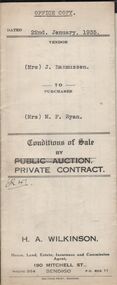
Document - H.A. & S.R. WILKINSON COLLECTION: CONTRACT OF SALE
Conditions of sale by private contract dated 22nd January, 1935 between Mrs. J. Rasmussen (seller) and Mrs. M.F. Ryan (buyer) for land situate No. 629 Hargreaves Street, Bendigo described in certificate of registration residence area No. ? Together with 5-roomed weatherboard dwelling and all sundry. Price 400 pounds.organization, business, h.a. & s.r wilkinson real estate -
 Bendigo Historical Society Inc.
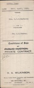
Document - H.A. & S.R. WILKINSON COLLECTION: CONTRACT OF SALE
Conditions of sale by private contract dated 24th April, 1935 between Mrs. A.E.J. Mayberry (seller) and Mr. A.E. Ramsey (buyer) for land situate Spring Gully, Bendigo being land described in certificate of registration residence area No. 33215, together with 5-roomed weatherboard dwelling and all sundry. Price 235 pounds.organization, business, h.a. & s.r wilkinson real estate -
 Bendigo Historical Society Inc.
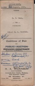
Document - H.A. & S.R. WILKINSON COLLECTION: CONTRACT OF SALE
Conditions of sale by private contract dated 3rd August, 1950 between E.N. Dean (seller) and Miss E.A. Packham (buyer) for land situate No. 1 Dillon Street, Long Gully being Crown allotment 497 section K described in certificate of title volume 3999 folio 799707, together with 3-roomed weatherboard dwelling and all sundry. Price 1,650 pounds. Also attached letter dated 5th August, 1950 signed by Mr. Dean to Messrs. Williams, Watson & James solicitors advising them to pay Mr. H. Button of 28 Harrison Street, Bendigo the sum of 32 pounds from the proceeds of the sale of property.organization, business, h.a. & s.r wilkinson real estate -
 Bendigo Historical Society Inc.
Document - H.A. & S.R. WILKINSON COLLECTION: CONTRACT OF SALE
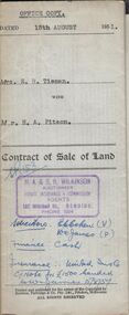
Contract of sale of land dated 15th August, 1951 between Mrs. E.R. Tieman (seller) and Mr. H.A. Pitson (buyer) for land being part of Crown allotment 6 section 71C described in certificate of title volume 4173 folio 834590 situate No. 47 Station Street, Bendigo, together with 4-roomed weatherboard dwelling and all sundry. Price 1,720 pounds.organization, business, h.a. & s.r wilkinson real estate -
 Bendigo Historical Society Inc.
Document - H.A. & S.R. WILKINSON COLLECTION; CONTRACT OF SALE
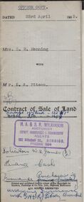
Contract of sale of land dated 23rd April, 1953 between Mrs. L.M. Manning (seller) and Mr. L.A. Pitson (buyer) for land situate 134 Bannister Street, Bendigo being north-east of and about 195 links from allotment 503 section K described in right to occupy residence area right No. 4612, together with 5-roomed weatherboard dwelling and all sundry. Price 1,350 pounds.organization, business, h.a. & s.r wilkinson real estate -
 Bendigo Historical Society Inc.
Document - H.A. & S.R. WILKINSON COLLECTION: CONTRACT OF SALE
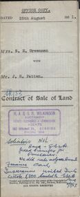
Contract of sale of land dated 25th August, 1951 between Mrs. S.E. Greenman (seller) and Mr. J.H. Patten (buyer) for land situate No. 1 Bobs Street, Bendigo described in right to occupy residence area No. 266, together with 4-roomed weatherboard dwelling and all sundry. Price 1,050 pounds.organization, business, h.a. & s.r wilkinson real estate -
 Bendigo Historical Society Inc.
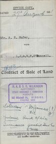
Document - H.A. & S.R. WILKINSON COLLECTION: CONDITION OF SALE
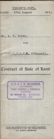
Contract of sale of land dated 27th August 1951 between Mr. A.H. Hufer (seller) and L.J. & W.E. O'Donnell (buyer) for land being part of Crown allotment 11 and 12 section 110C described in certificate of title volume 5322 folio 1064288 situate No. 131 Russell Street, Bendigo, together with 4-roomed weatherboard dwelling and all sundry. Price 2,750 pounds. Vendor's copy.organization, business, h.a. & s.r wilkinson real estate -
 Bendigo Historical Society Inc.
Document - H.A. & S.R. WILKINSON COLLECTION: CONDITION OF SALE
Contract of sale of land dated 27th August 1951 between Mr. A.H. Hufer (seller) and L.J. & W.E. O'Donnell (buyer) for land being part of Crown allotment 11 and 12 section 110C described in certificate of title volume 5322 folio 1064288 situate No. 131 Russell Street, Bendigo, together with 4-roomed weatherboard dwelling and all sundry. Price 2,750 pounds. Also attached handwritten note from Williams, Watson & James solicitors and receipts for 100 pounds deposit for sale.organization, business, h.a. & s.r wilkinson real estate -
 Bendigo Historical Society Inc.
Document - H.A. & S.R WILKINSON COLLECTION: CONDITION OF SALE
Contract of sale of land dated 19th May, 1952 between Mrs. A.M. McGown (seller) and Mr. H.A. Pitson (buyer) for land being Crown allotment 6 section 128C described in certificate of title volume 6410 folio 1281821 situate No. 24 Havelock Street, Bendigo, together with 6-roomed weatherboard dwelling and all sundry. Price 2,800 pounds.organization, business, h.a. & s.r wilkinson real estate -
 Bendigo Historical Society Inc.
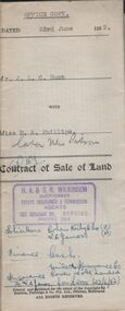
Document - H.A. & S.R. WILKINSON COLLECTION: CONDITION OF SALE
Contract of sale of land dated 23rd June, 1952 between Mr. J.L.C. Hunt (seller) and Miss D.A. Phillips for land being Lot 18 on plan of subdivision No. 14194, being part of Crown allotments 454A and 476 section H described in certificate of title volume 6110, folio 975 situate in Murray Street, Bendigo, together with 50roomed weatherboard dwelling and all sundry. Price 2,525 pounds.organization, business, h.a. & s.r wilkinson real estate -
 Bendigo Historical Society Inc.
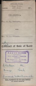
Document - H.A. & S.R. WILKINSON COLLECTION: CONDITION OF SALE
Contract of sale of land dated 4th July, 1952 between Mr. D. R. McClure (seller) and Mr.. H. A. Pitson for land described in right to occupy residence area No. 9508, together with all buildings and erection thereon, also all sundries inside and outside the building. Price 60 pounds. Also attached various receipt from Department of lands and survey, copy of the right to occupy land issued in 1942, letter from the City of Bendigo dated in 1951 drawing attention to unpaid rates on the property.organization, business, h.a. & s.r wilkinson real estate -
 Bendigo Historical Society Inc.
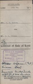
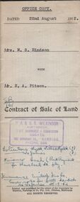
Document - H.A. & S.R. WILKINSON COLLECTION: CONDITION OF SALE
Contract of sale of land dated 22nd August, 1952 between Mrs. M.S. Hindson (seller) and Mr. H. A. Pitson (buyer) for land being allotment 363 section H described in Crown grant volume 864 folio 761 situate No.10 Wolstencroft Street, Bendigo, together with 6-roomed weatherboard and brick dwelling and all sundry. Price 1,700 pounds.organization, business, h.a. & s.r wilkinson real estate -
 Bendigo Historical Society Inc.
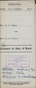
Document - H.A. & S.R. WILKINSON COLLECTION: CONDITION OF SALE
Contract of sale of land dated 28th November, 1952 between Mrs. M.M. Goyne (seller) and Mr. H.A. Pitson (buyer) for land situate No. 140 Lily Street, Bendigo being allotment 21 section 39B described in right to occupy residence area No. 4775, together with weatherboard dwelling and all sundry. Price 1,075 pounds.organization, business, h.a. & s.r wilkinson real estate