Showing 645 items
matching railway road bridge
-
 Eltham District Historical Society Inc
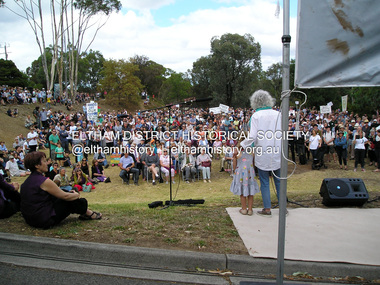
Photograph, Fay Bridge, Save Community Reserves Rally, 895 Main Road, Eltham, 7 November 2017
Protest rally against Nillumbik Shire Councillors' proposal to sell off 17 community reserves. Held at the site of the former Shire of Eltham offices, at 895 Main Road, which were demolished in August 1996, followed by a march along Main Road finishing at the Eltham Railway Station car park at Luck Street. Estimated attendance was approximately 3,000.fay bridge collection, 895 main road, 2018-03-04, margaret jennings, nillumbik shire council, parks, save community reserves protest rally, save our reserves -
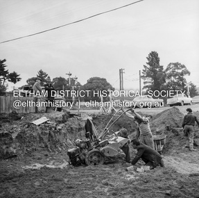
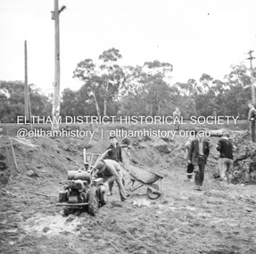
 Eltham District Historical Society Inc
Album - Photograph Album, J.A. McDonald, Bridge and Road Reconstruction Works, Shire of Eltham, 1952-1962
J.A. McDonald produced this record in the course of his responsibilities as Shire Engineer for Eltham Shire Council.Record of various Shire of Eltham infrastructure works undertaken during the period of 1952-1962 involving bridge and road reconstruction projects, sometimes with Eltham Shire Council Project Reference numbers quoted. It was during this period that a number of significant improvements were made to roads and new bridges constructed within the shire that remain in place as of present day (2022). In many situations, the photos provide a tangible visible record of infrastructure that existed throughout the early days of the Shire. The album was put together by or under the direction of the Shire Engineer, J.A. McDonald.a. gillies, alistair knox park, benchmark studies, bend of islands, blease road, box hill state school, box hill teachers college, box hill tip, bridge construction, bridge street bridge, bridge, brisbane street, brougham steet, bulldozer, cecil street, charis pelling, cherry tree road, city of preston, cr. a. brinkkotter, cr. charis pelling, cranes, cromwell street, diamond creek (creek), diamond street, dixons creek bridge, dixon's creek road, drott, eltham leisure centre, eltham north, eltham police station, eltham, eltham-yarra glen road, f. wood, fitzsimons lane bridge, flat rock road, flood damage, floods, floodwater, footpaths and gutters, ford service garage, g. blair, garden hill, glen park bridge, glenauburn road, grand hotel, haldane road, healesville, healesville-yarra glen road, heidelberg-kinglake road, henley road bridge, henley road, hill property, hurstbridge water scheme, hurstbridge, hurstbridge-arthurs creek road, infrastructure, j. jolly, kangaroo ground, kangaroo ground-queenstown road, kangaroo ground-st andrews road, lilydale shire office, long gully bridge, long gully creek, long gully road, long gully, lower plenty bridge, lower plenty footbridge, lower plenty oval, lower plenty road, lower plenty, main road, methodist church, montmorency, mount pleasant road, new holland, old healesville road, opening ceremony, oxley bridge, para road, paul creek bridge, paul creek road, paul krafeznk, pinnacle lane, plaques, plenty river trail, plenty river, presbyterian church, prof donald thomson, pryor street, railway crossing, railway parade, rattray road, reconstruction works, reichelt avenue, research (vic.), research oval, road construction, rymers corner, shire of eltham, shire of whittlesea, silvan road bridge, silver street bridge, silver street, sir dallas brooks, smedley property, st andrews, steels creek, susan street, tarrawarra, tony carberry, uniting church, upper yarra dam, upper yarra reservoir, w.e. wolf, waterfall property, watsons creek, wattletree road bridge, wattletree road, wattletree road bridge, worlingworth, yarra glen, york street, yow yow creek -
 Eltham District Historical Society Inc
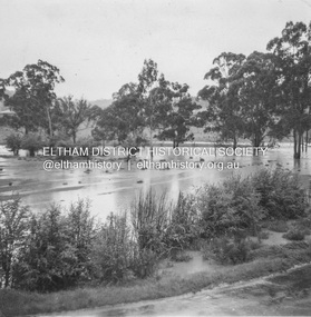
Album - Photograph, J.A. McDonald, Eltham-Diamond Creek Road, 21 Oct. 1953
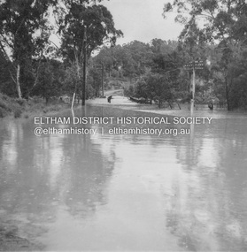
18 October 1956 Proposed upstream line over Diamond Creek from Diamond Creek sideRecord of various Shire of Eltham infrastructure works undertaken during the period of 1952-1962 involving bridge and road reconstruction projects, sometimes with Eltham Shire Council Project Reference numbers quoted. It was during this period that a number of significant improvements were made to roads and new bridges constructed within the shire that remain in place as of present day (2022). In many situations, the photos provide a tangible visible record of infrastructure that existed throughout the early days of the Shire. The album was put together by or under the direction of the Shire Engineer, J.A. McDonald.infrastructure, road construction, shire of eltham, bridge construction, eltham north, floods, floodwater, glen park bridge, 1956-10-18, diamond creek (creek), eltham, railway parade, wattletree road, wattletree road bridge -
 Eltham District Historical Society Inc
Album - Photograph, J.A. McDonald, Eltham-Diamond Creek Road, 21 Oct. 1953
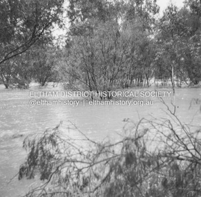
18 October 1956 Flooding on downstream line from Diamond Creek sideRecord of various Shire of Eltham infrastructure works undertaken during the period of 1952-1962 involving bridge and road reconstruction projects, sometimes with Eltham Shire Council Project Reference numbers quoted. It was during this period that a number of significant improvements were made to roads and new bridges constructed within the shire that remain in place as of present day (2022). In many situations, the photos provide a tangible visible record of infrastructure that existed throughout the early days of the Shire. The album was put together by or under the direction of the Shire Engineer, J.A. McDonald.infrastructure, road construction, shire of eltham, bridge construction, eltham north, floods, floodwater, glen park bridge, 1956-10-18, diamond creek (creek), eltham, railway parade, wattletree road, wattletree road bridge -
 Eltham District Historical Society Inc
Album - Photograph, J.A. McDonald, Eltham-Diamond Creek Road, 21 Oct. 1953
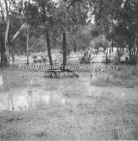
18 October 1956 New downstream alignment from Eltham sideRecord of various Shire of Eltham infrastructure works undertaken during the period of 1952-1962 involving bridge and road reconstruction projects, sometimes with Eltham Shire Council Project Reference numbers quoted. It was during this period that a number of significant improvements were made to roads and new bridges constructed within the shire that remain in place as of present day (2022). In many situations, the photos provide a tangible visible record of infrastructure that existed throughout the early days of the Shire. The album was put together by or under the direction of the Shire Engineer, J.A. McDonald.infrastructure, road construction, shire of eltham, bridge construction, eltham north, floods, floodwater, glen park bridge, 1956-10-18, diamond creek (creek), eltham, railway parade, wattletree road, wattletree road bridge -
 Eltham District Historical Society Inc
Album - Photograph, J.A. McDonald, Eltham-Diamond Creek Road, 21 Oct. 1953
18 October 1956 Proposed upstream line from Eltham sideRecord of various Shire of Eltham infrastructure works undertaken during the period of 1952-1962 involving bridge and road reconstruction projects, sometimes with Eltham Shire Council Project Reference numbers quoted. It was during this period that a number of significant improvements were made to roads and new bridges constructed within the shire that remain in place as of present day (2022). In many situations, the photos provide a tangible visible record of infrastructure that existed throughout the early days of the Shire. The album was put together by or under the direction of the Shire Engineer, J.A. McDonald.infrastructure, road construction, shire of eltham, bridge construction, eltham north, floods, floodwater, glen park bridge, 1956-10-18, diamond creek (creek), eltham, railway parade, wattletree road, wattletree road bridge -
 Eltham District Historical Society Inc
Album - Photograph, J.A. McDonald, Eltham-Diamond Creek Road, 21 Oct. 1953
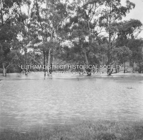
18 October 1956 Flooding on Diamond Creek 17th October 1956 (not max.) This view is looking southwest along Railway Parade (now present-day Gastons Road) past Mrs Lucy Egan's house now owned by the Bakos family, purchased by Mrs Heather Bakos in 1960Record of various Shire of Eltham infrastructure works undertaken during the period of 1952-1962 involving bridge and road reconstruction projects, sometimes with Eltham Shire Council Project Reference numbers quoted. It was during this period that a number of significant improvements were made to roads and new bridges constructed within the shire that remain in place as of present day (2022). In many situations, the photos provide a tangible visible record of infrastructure that existed throughout the early days of the Shire. The album was put together by or under the direction of the Shire Engineer, J.A. McDonald.infrastructure, road construction, shire of eltham, bridge construction, eltham north, floods, floodwater, glen park bridge, 1956-10-18, diamond creek (creek), eltham, railway parade, wattletree road, wattletree road bridge, gastons road -
 Eltham District Historical Society Inc
Album - Photograph, J.A. McDonald, Eltham-Diamond Creek Road, 21 Oct. 1953
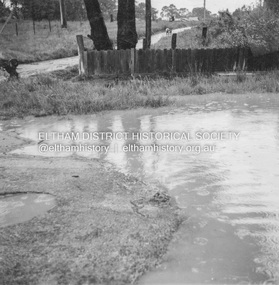
... to the Wattletree Road bridge being built, Railway Parade extended up... to the Wattletree Road bridge being built, Railway Parade extended up ...18 October 1956 Flood level on road at corner of Railway Parade. On the immediate left out of view is Mrs Lucy Egan's home. That house still stands today nestled up against the Wattletree Road Bridge on the other side built in 1959 and is owned by the Bakos family purchased by Mrs Heather Bakos in 1960.. Prior to the Wattletree Road bridge being built, Railway Parade extended up the alignment of present-day Gastons Road to the Eltham-Diamond Creek road which ran past the entrance of the present-day carpark for Edendale Farm. This view is looking west across the Glen Park Bridge, and the beginning of Wattletree Road which sweeps around to the right in the distance. Progress Road does not exist though a road reserve is present on maps.Record of various Shire of Eltham infrastructure works undertaken during the period of 1952-1962 involving bridge and road reconstruction projects, sometimes with Eltham Shire Council Project Reference numbers quoted. It was during this period that a number of significant improvements were made to roads and new bridges constructed within the shire that remain in place as of present day (2022). In many situations, the photos provide a tangible visible record of infrastructure that existed throughout the early days of the Shire. The album was put together by or under the direction of the Shire Engineer, J.A. McDonald.infrastructure, road construction, shire of eltham, bridge construction, eltham north, floods, floodwater, glen park bridge, 1956-10-18, diamond creek (creek), eltham, railway parade, wattletree road, wattletree road bridge, gastons road -
 Eltham District Historical Society Inc
Album - Photograph, J.A. McDonald, Eltham-Greensborough Road, 18 Oct. 1956
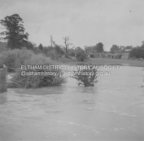
Bridge Street Bridge Flooding on Hill’s property 18th October 1956 This view is looking west north west from the Bridge Street Bridge across the present day Eltham Skatepark. The shed visibile in the distance is directly opposite Brisbane Street where it used to run into Susan Street but now turns the corner. To the right of the shes is the site for present-dayHarris Plumbing which was formerly occupied by Sibbel Builders; to the left the site now occupied by Bunnings. At the skyline to the right of centreeline is a gap in the trees where the railway line runs. The Silver Street bridge over the railway is visible. Beware!.. our rivers are rising (1956, October 19). The Argus (Melbourne, Vic. : 1848 - 1957), p. 1. Retrieved August 24, 2022, from http://nla.gov.au/nla.news-article84392304Record of various Shire of Eltham infrastructure works undertaken during the period of 1952-1962 involving bridge and road reconstruction projects, sometimes with Eltham Shire Council Project Reference numbers quoted. It was during this period that a number of significant improvements were made to roads and new bridges constructed within the shire that remain in place as of present day (2022). In many situations, the photos provide a tangible visible record of infrastructure that existed throughout the early days of the Shire. The album was put together by or under the direction of the Shire Engineer, J.A. McDonald.infrastructure, road construction, shire of eltham, bridge construction, bridge street bridge, eltham, eltham-greensborough road, 1956-10-18, diamond creek (creek), floods, floodwater, hill property, silver street bridge -
 Eltham District Historical Society Inc
Document - Folder, McLean, 1984-1999
References to McLean family, Hector John McLean and Louisa Frances (nee Green) and six daughters who lived in Eltham during the period 1930 to 1934 inclusive. Lived in the former Evelyn Hotel at the time it was destroyed by fire and being part of the Centenary Parade in 1934 where the family won the Group Section for their entry “Pioneers of Eltham” Reminiscences provided by Edith Jones (nee M1934 flood, ballroom, baptism, barber shop, bittern, boy scouts, bremner's flat, burgoyne's shop, cable tram, cemetery road, centenary celebrations, centenary parade, christening, coach house, collis grocery, dalton street, depression, dole, dorothy jean mclean, edith jones (nee mclean), eltham fire brigade, eltham high school, eltham higher elementary school, eltham lower park, eltham railway station, eltham state school no. 209, evelyn hotel, fire damage - buildings, flinders naval depot, fordham, gladys evelyn mclean, gold mining, gwenneth mae mclean, gwladys evelyn mclean, headmistress, hector john mclean, isherwood house and shop, louisa frances mclean (nee green), metery road, methodist church, miss finnin, miss grant cottage, motor bike races, mrs barrett, mrs bremner, mrs hurley, olive isabel mclean, parade, phoebe lillian mclean, picnic, pioneers of eltham, pitt street, research fire brigade, rev. r.g. arthur, shed, shops, st margarets church hall, st margaret's church, stables, state savings bank of victoria, susso books, todaro, vinnie willet, warrandyte bridge, warrandyte, wingrove park, yarra river -
 Eltham District Historical Society Inc
Negative - Photograph, J.A. McDonald, Eltham, Cecil Street, Sep. 1959
Stabilising junction with Eltham-Yarra Glen Road View looking west across Main Road to Diamond Street railway crossingRecord of various Shire of Eltham infrastructure works undertaken during the period of 1952-1962 involving bridge and road reconstruction projects, sometimes with Eltham Shire Council Project Reference numbers quoted. It was during this period that a number of significant improvements were made to roads and new bridges constructed within the shire that remain in place as of present day (2022). In many situations, the photos provide a tangible visible record of infrastructure that existed throughout the early days of the Shire. The album was put together by or under the direction of the Shire Engineer, J.A. McDonald.infrastructure, shire of eltham, road construction, cecil street, diamond street, eltham, eltham-yarra glen road, main road, railway crossing, 1959-09 -
 Eltham District Historical Society Inc
Negative - Photograph, J.A. McDonald, Eltham, Cecil Street, Sep. 1959
Stabilising junction with Eltham-Yarra Glen Road View looking west across Main Road to the railway lineRecord of various Shire of Eltham infrastructure works undertaken during the period of 1952-1962 involving bridge and road reconstruction projects, sometimes with Eltham Shire Council Project Reference numbers quoted. It was during this period that a number of significant improvements were made to roads and new bridges constructed within the shire that remain in place as of present day (2022). In many situations, the photos provide a tangible visible record of infrastructure that existed throughout the early days of the Shire. The album was put together by or under the direction of the Shire Engineer, J.A. McDonald.infrastructure, shire of eltham, road construction, cecil street, eltham, eltham-yarra glen road, main road, 1959-09 -
 Glen Eira Historical Society
Article - Attwood Family
Two items about the Attwood Family: A seventeen page computer typed copy of the memories of John Attwood, compiled by Colin Smith in January 2002. Includes memories of his childhood, contact and impressions of local identities including Merric Boyd and others; the retailers and business owners in the Murrumbeena area, the trains and railway stations, picture theatres and other businesses. A photocopy of an article taken from the Herald Sun newspaper 06/11/2007. Myra Attwood, wife of John, local business person in Murrumbeena Newsagency; includes brief local history of family and Myra’s personal hobbies, till the time of her death. Also a newspaper clipping of her death notice, unknown source and date.emily street, murrumbeena, elsternwick, railway stations, signal boxes, beena avenue, murrumbeena state school, primary schools, attwood john, attwood myra, attwood rhonda, attwood colin, attwood warren, attwood murray, attwood janine, attwood susan, attwood michael, attwood greg, attwood gerard, black bridge, outer circle railway, murrumbeena newsagency, newsagents, murrumbeena railway station, railway stations, book binders, stevens alf, sykes harold, attwood motors, neerim road, boyd merric, boyd mrs., timber houses, outbuildings, artists, trains, car parks, christie’s woodyard, ferguson cam, railway accidents, ardyne street, north road, dalny road, brett street, barnes family, newspapers, roads and streets, soils, flower growing, market gardens, world war 1939-1945, land subdivisions, air raid precautions, bicycles, drawing, springthorpe park, mass media, murrumbeena shopping centre, butcher shops, grocer shops, green grocers, shoe shops, confectionary shops, barber shops, beck george, bowyer ralph, rennie bill, bookmakers, presbyterian church, methodist church, hanna’s milk bar, sunday school, woodland bill, ssw grocery chain, drays, woodland alec, lee ron, jewellers, bakeries, fish shops, dressmakers, delicatessens, east bentleigh, selkrigs family, pottery, heads’ garage, head lindsay, head doug, head clarry, head ron, murrumbeena road, car retailers, petrol pumps, motor vehicle repair shops, billy one motors, bird mr., real estate agents, w.b. tonks and company, sparrow mr., pidgeon mr., hardware stores, florist shops, murrumbeena post office, tile shops, gardens, murrumbeena chamber of commerce, kiosks, gardeners, carnegie citizens band, spurway nursing home, argosy theatre, cinemas, dance halls, the capri, theatre groups, caulfield council, the blowfly train service, billiard rooms, printers, hammond olsen and company, l.j. miles and company, moody’s real estate agency, paddocks, flats, es&a bank murrumbeena, esanda bank murrumbeena, state savings bank murrumbeena, commonwealth bank murrumbeena, fuel merchants, hobart road, golden fleece service station, quince’s buses, bus services, ardyne street, timber yard, gow mr., railway parade, shell service station, pharmecies, house miss, bicycle shops, barnhill les mr., fliner mr., boot makers, widdop peter, moran and cato’s, grocers, pizza shop, car yards, classic caravan, o’brien kevin, wrought iron work, williams mr., candle making factory, lights, power tom, gates, fences, whitelaw monier tiles, whitelaw bill, hanna rex, dandenong road, cumloden grammar school, independent schools, emmaus rest house, oakdene, house names, taranto bob, hanson cab service, billy one motors, grey mr., horse troughs, horse drawn vehicle, taxis, board roy, buick cars, charleston’s bakery, carnegie, rosstown hotel, corum’s dairy, kangaroo road, reids dairy, dalny road, reid shaver, racehorses, cove’s dairy, wilson street, police, murrumbeena police station, dunoon street, murrumbeena park, footballers, gangs, liberal party, labour party, united australian party, uap, woodland alec, liquor shops, johnson suzanne, singers, taylor squizzy, boyd family, artists, criminals, skase christopher, skase charles, sunaria competition, herald and weekly times, ralph j.w., j.h. ralph butchers, butcher shops, pennington gardens, home units, flats, schrape frank, builder, smith colin, mansions, death registers, hockley myra, esperanto, book keepers, accountants, solicitors -
 Eltham District Historical Society Inc
Photograph, Upper Yarra Dam, Spring Tour, 22 Oct 1995, 22/10/1995
EXPLORING THE UPPER YARRA (Newsletter No. 105, November 1995, by Bettina Woodburn) We enjoyed the Spring Excursion, this year "Exploring the Upper Yarra" - in spite of the constant rain and the countryside under the cloud cover, especially in the valleys, being mainly shiny shades of green. The occasional fields of buttercups, clumps of arum lilies and splendid rhododendron and other flowering bushes became very special. The Cobb and Co coach was warm and a cosy retreat as we zig-zagged on the highways and byways to glimpse the Yarra River, upstream and down, its secret places, and particularly the many bridges. Russell excelled as 'Poet Laureate', reading from Dacre Smyth's book. This 1979 publication includes paintings of all the bridges along the river with poems and brief descriptions of each one. Some of the bridges are in out of the way places and are not very well known. We looked forward to hearing the poetry as much as seeing the ' constructions'…Big Pat (was he short or tall, lean or fat? He did win the two hundred pound reward for discovering gold and had the creek named after him), about the 'Eddies'?, and the disliked 'meccano' bridge in Warburton, etc. etc. The hot roast lunch in the old Reefton Hotel was also most welcome. It was easy to imagine it peopled by miners and early settlers. Starting by crossing the new (1974) concrete bridge at Warrandyte we headed through Wonga Park with views to the Christmas Hills and to the escarpment of the Yering Gorge, which causes flood waters to back up through the Yarra Glen plain, so avoiding disasters downstream. At the end of a long driveway we found the wooden, privately owned Henley Bridge (1935 after the 1934 floods). This facilitates access to different parts of Henley Farm and to Lilydale. Everard Park, named after Blanche Shallard's father, a State Member for 17 years, below the Highway Yarra crossing was in need of care. It is 10 miles from Yarra Glen by road but, as "Yarra Marra” canoeists well know, 32 winding miles down by water. After more delightful countryside scenes we joined the Warburton Highway at Woori Yallock. From the old Railway Station at Launching Place the Centennial Trail for walkers, cyclists and ' horse riders has replaced the rails. The line from Lilydale was opened in 1901, and the last diesel freight train ran to Warburton in 1965. It continued to rain as we had morning tea in Warburton in a shelter between footbridges. From here we continued upstream past the Bridge to O'Shannasy Lodge and Reservoir, Starvation Creek, and the Peninsular tunnel (miners dug it as at Pound Bend) which we visited (scrambling down those steps!) on our return after lunch. Our furthermost point was the Upper Yarra Dam Reserve (and vast catchment area). Finished in 1957 after ten years work and 100 years after Yan Yean, it supplies much of Melbourne's water. After crossing the 30m Launching Place Bridge to the Eltham side of the Yarra and Healesville, we saw in the distance the Yarra Glen Timber Trestle Bridge over the river flats "the longest for years in the land it was said!" Harry's dream of "better weather over the Divide" unfortunately didn't come true, but I'm sure we 36 members will retain happy memories of a day that was wet and green and filled with Bridges. Bettina Woodburn - October 1995 Record of the Society's history of activities - Spring 1995 excursionColour photographshire of eltham historical society, activities, upper yarra dam, henley bridge -
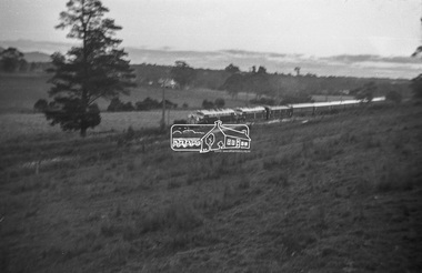 Eltham District Historical Society Inc
Photograph, George Burton Coop, The Royal Train enroute to Lilydale, near Croydon, 6 Mar. 1954
Believed to have been taken bewteen Croydon Railway Station and the Dorset Road bridge. Taken late afternnon by George Coop's father. There is a Landrover parked on the grass with a person standing on it - believed to be Security. George recalls originally being located closer to the fence and being ushered up the hill where it was 'safer' to stand. In 1954 at age 27, Queen Elizabeth II was the first reigning British monarch to visit Australia.. She visited Victoria between March 1-10. Where to see the Queen (1954, January 21). Fern Tree Gully and District Times (Boronia, Vic. : 1953-1954), p. 5. Retrieved October 25, 2021, from http://nla.gov.au/nla.news-article264220429 “The Lilydale Shire President, Cr. Burgi, stated that the Royal train en route for Warburton on Saturday, March 6th, would slow down at Croydon and Lilydale. There was little possibility that it would stop at either of these towns. The train would pass through Lilydale at 5.52 p.m. Council had appointed a sub-committee to arrange matters, and had allocated £400 towards expenses. It was suggested that the train slow down between the railway station and Dorset Rd. bridge at Croydon, and between the Cave Hill Quarry and railway station at Lilydale.” An album of images of the Queen's visit to Victoria is available on the PROV Flickr account at https://www.flickr.com/photos/public-record-office-victoria/7252885616Digital TIFF file Scan of Kopdak 620 black and white negative transparencygeorge coop collection, croydon, royal train -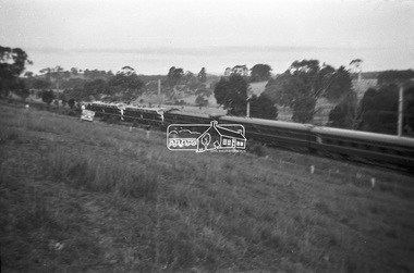
 Eltham District Historical Society Inc
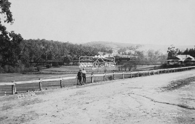
Photograph (item), J.H. Clark, View of Eltham from Main Road, c.1907
An F-class 2-4-0 steam locomotive and tender hauls a train of two open wagons, a guards van and a single Tait passenger car over the Eltham Railway Trestle Bridge, heading for Melbourne. This type of steam locomotive was replaced by the F-Class 2-4-2. The house on the right, originally known as 'Derril' was purchased in the early 1920s by Walter Ernest and Alice Miriam Gahan. On the western side of Main Road near the present-day site of Shillinglaw Cottage, they remained till about 1960 when Walter died. The house was demolished in 1968 during the widening of Main Road. In the distance beyond the trestle bridge on what would become Central Park appears to be an orchard of fruit trees. A young man with waist coat, jacket and hat stands beside an older man wearing suspenders without jacket and bare headed, sitting on the post fence. Photographer: J.H. Clark John Henry Clark was the youngest of three boys born to William Henry Clark (1823-1877) and Maria White (1843-1914). He and his brothers, William Charles Clark (1872-1945), Clement Kent Clark (1874-1912) operated a photography business (Clark Bros.) from 25 Thomas Street, Windsor near Prahran during the period c.1894 to 1914. Following death of Clement in September 1912 and their mother in 1914, the Clark Bros business appears to have dissolved, the premises demolished, and a new house was under construction in 1915. John set up business independently in 1914 operating out of 29 Moor Street, Fitzroy where he is registered in the 1914 and 1915 Electoral Rolls. By 1916 John had relocated to Eltham where he continued his practice as a photographer and took many of the early images around the district of Little Eltham. Around 1930 John changed professions and opened a small cobbler's shop in 1931 near the pond opposite Dalton Street adjacent to the Jarrold family cottage. He never married and continued his profession as a bootmaker from this little shop, maintaining a close relationship with Mrs Jarrold for the rest of their lives. His bootmaker shop remains today beside the Whitecloud cottage and is one of only three remaining shops in the area from the early 20th century. There are a couple of images of Eltham taken by Clark Bros. in the Eltham District Historical Society collection, one such example being Hunniford’s Post Office with Miss Anne Hunniford out front (EDHS_00140 - marked on the back of the print, Clark Bros., 25 Thomas St. Windsor), which would date this image between c.1894 and 1914. Other early images of Eltham taken by John Henry Clark are marked on the face “J. H. Clark Photo” and it is assumed these are dated between 1914 and 1930. It is noted that the Grant of Probate for John H Clark of Eltham South dated 5 April !957 (513/387) records his occupation as "X Photographer".derril, eltham railway trestle bridge, f-class 2-4-0 steam locomotive, gahan house, j.h. clark photo, main road, orchards, postcards, steam train, tait train, victorian railways -
 Eltham District Historical Society Inc
Photograph, Tess Justine (Nillumbik Shire Council), Murray's Bridge over the Diamond Creek, Eltham North, 19 Feb 2022
Murray's Bridge over the Diamond Creek on the Diamond Creek Trail just prior to demolition and replacement with a new steel bridge. Heritage advice obtained by Nillumbik Shire Council, following a suggestion by the Eltham District Historical Society (EDHS), is that the original bridge appears to have been a simplified version of the Country Roads Board’s (CRB) standard timber bridge design of the early-to-mid 1920s. In c1990 Murray’s bridge was renovated with three recycled steel girders as part of a bike/pedestrian path in the reserve. During these alterations many parts of the bridge were removed, and some were replaced. Heritage advice indicates the condition of Murray’s bridge is poor. The remaining original parts are all in poor condition, with severe weathering, splitting and rot, especially to the stringers retained on the bridge. Heritage advice is that Murray’s Bridge does not have sufficient significance in the cultural history of the Nillumbik area to warrant inclusion in the Nillumbik Shire Heritage Overlay and also does not have sufficient significance as a rare survivor to warrant inclusion in the Nillumbik Shire Heritage Overlay. There are no indications in the historical record that this site was individually important to the cultural history of this area. EDHS is comfortable with the heritage advice provided to Council and has worked closely on this project with Council. EDHS has suggested some of the removed timbers be used in the vicinity of the bridge for landscaping and possibly seating, so as to retain these remnants close to the site of the original bridge, which is the last old timber bridge along the lower reaches of the Diamond Creek. Mary (Sweeney) Murray and John Wright Murray selected 80 acres, Lot C Section 16 and Lot 5 Section 17 Parish of Nillumbik, under an occupation license in 1866. John died in 1867 and freehold was granted to his son John in 1873. The farm was known as ‘Laurel Hill’. John Junior was an Eltham Shire councillor and sometime president from 1887 up until 1897. He added Lot A Section 16 to the farm in ca1888. John and his younger brother James arranged to rent/purchase Lot B Section 17, across Diamond Creek to the west, in ca1900. It appears that John and James farmed separately for a few years, with a new homestead built for James ad family on the high point of Lot B Section 17 in ca1910. John sold off Lot 5 Section 17 in 1912. When John died in 1912 James took over the land on both sides of the Diamond Creek. The old homestead on the west side of the Creek disappeared. A farm bridge over Diamond Creek from this period may have been located close to the northern boundary of the farm. John Langlands, owner of the farm known as ‘Ihurst’ on the west side of Diamond Creek to the south of the Murray’s land, died in 1907. In 1909 his land was then subdivided into 100 lots to become the ‘Glen Park Estate’. Other similar subdivisions of nineteenth century farms around Eltham in this period included the ‘Franktonia (or Beard’s) Estate’ to the northeast and ‘Bonsack’s Estate’ between Eltham and Greensborough. Soon after the opening of the railway extension line from Eltham to Hurstbridge in 1912, Glen Park and nearby residents including James Murray agitated for a railway station or siding to be located half-way between Eltham and Hurstbridge, so that the Glen Park residents who used the railway daily did not have to walk into the Eltham or Hurstbridge stations. Some believed Coleman’s Corner (opposite Edendale Farm) was an appropriate spot for the platform. James Murray was among those who thought the railway should be located on his land, closer to half-way between Eltham and Hurstbridge stations. The Railways Commissioners warned that the locals would have to fund these works themselves. The Glen Park Estate residents initially had difficulty accessing Eltham by road, with only an old low-level bridge over Diamond Creek at the south end of their estate. A new timber trestle bridge across the creek, now on Wattletree Road, was opened in 1915. Road access to the north was gained in 1927 when the new Murray’s Road, which crossed the Murray’s land, was built. Residents continued to agitate for a Glen Park station. By 1926 the Railways Commissioners’ preferred site was on the Murray’s land. They arranged an estimate of cost of a full-length platform. The estimate was too much for the locals, who in 1928 argued unsuccessfully for a shorter and hence cheaper platform. By 1929 Murray had agreed to donate the land, but the locals would still have to fund the works. Murray decided, unilaterally it would appear, to commence work on a timber trestle road bridge over Diamond Creek to link the new Murray Road to the proposed station. Late in 1929 he stopped work on the bridge, for reasons unknown, but started work again and completed the bridge in 1931. There is no further newspaper evidence of the campaign for the Glen Park station until 1939, when Murray and another local, Mr Maxwell, met the Railways Commissioner. The Glen Park locale now included 45 homes on the west side of the creek and 20 on the Eltham side. Most of the residents used the train every day. The Commissioner remained adamant that only a full-length platform could be built for safety reasons. It appears the campaign dissolved at this point. The increasing move to cars may have had an impact. There is no evidence of Murray’s bridge ever being connected to Murray’s Road, or of it having wide use for any purpose by locals. James Murray died in 1947 and the farm was taken over by his son James (Jim). Jim started to sell off parts of the farm in the 1980s, retaining a few acres around the ca1910 homestead and building a new house there. Recreation reserves were established along the creek. In ca1990 Murray’s bridge was renovated with steel girders as part of a bike/pedestrian path in the reserve. The old farmhouse was demolished in ca2014. * * * A theory posted on local community Facebook groups was that the bridge was built in the 1860s and was built to be more robust than was necessary for the movement of cows from one side of the creek to the other. It was suggested the robustness was necessary to support the weight of gold ore being transferred from a mine on Murray’s land to a railway siding near Murrays Bridge (presumably for transfer and processing at Diamond Creek). Perhaps this may have been one of the motivators for Murray, who really knows? Knowing when mining operations ceased on his land and how that fits the overall timeline would be useful but at the time the bridge was built, local gold production was minimal at best. The known facts are: • The railway line came to Eltham in 1902. • The extension of the railway from Eltham to Hurstbridge was constructed in 1912 so no railway line even existed through Murray's property until 1912 and the Victorian Railways maps at the time show no such siding on Murray’s property. • In 1923 a new company was formed in anticipation of the old Diamond Creek Gold Mine being re-opened. The mine had been previously closed and flooded. It was noted in the press at the time that the mine was within a mile of the railway. Nothing really came of this. • Construction of Murrays Bridge was commenced by James Murray in early 1929 in anticipation of a proposed flag station being nominated on his land, but work ceased shortly afterwards. The proposed flag station was commonly referred to as Glen Park as the residents of the Glen Park Estate wanted Option 1, located near them with the platform adjacent to Colemans corner. This was probably never going to fly as it was virtually in eyesight of Eltham station. Allandale Road was the third option, but the Commissioners' preferred option was No. 2 - on Murray's property. • The Railway Commissioners were not going to finance any such station and the works had to be funded by private landowners and residents, hence Murray investing in this himself. • Murray recommenced work two years later and finished his bridge in 1931 but unfortunately for him, the proposed flag station never eventuated. The bluestone siding you reference may well have been built by Murray as part of the proposed station platform. • Up until then, apart from the Main Road bridge, which was washed away in 1924, virtually all local crossings over the Diamond Creek were low lying bridges – Kaylocks Bridge at Brougham Street, Diamond Street bridge, Glen Park Road bridge. It is expected that Murray also had a low-lying bridge to connect his land either side of the creek. These were all washed away or severely damaged multiple times in the 1920s. Lessons were learnt, and Murrays Bridge appears to have been built in accordance with Country Road Board standards of the time. Flood damage was ongoing, and even more recently constructed raised bridges kept getting washed away, e.g., the new Wattle Tree Road bridge in 1958 just months after completion. Murray’s bridge was reinforced with steel some 30 years ago presumably to provide additional floodwater resistance, given the history of bridges disappearing in floodwaters. • In March 1932 it was reported in the Advertiser that there were still some prospectors operating around Eltham North who apart from further scarring the face of the earth over the previous two years had gained significant experience but little gold - hardly a driving factor for constructing a dedicated railway siding and bridge to transfer gold ore. It is far more probable that James Murray was hoping to have the railway station located on his property and invested his money by building the bridge to lead to it as well as a station platform. Had the station eventuated, it may well have driven up the value of his land for subdivision and new housing estates like the Glen Park Estate. That did not eventuate. Whilst the bridge was indeed old (90 years), the core structure being completed in 1931, it had been modified substantially from original and hence had no significant historic value – i.e., it was not a representative example of its type, construction, and age. Given that the bridge was not worthy of saving, the Eltham District Historical Society with Council’s support, and the Eltham Woodworkers group endeavoured to see what suitable sized timbers were salvageable to fabricate a commemorative seat. Unfortunately, the experts at the Woodworkers group were unable to salvage any suitable length/width timbers to fabricate the seat due to the presence of rot. Last remaining wooden trestle bridge on the Diamond Creek Trail just prior to demolition and replacementBorn digital image (27)diamond creek (creek), diamond creek trail, murrays bridge, ‘laurel hill’, john wright murray, mary (sweeney) murra, john murray jnr, james murray, john langlands, ‘ihurst’, ‘glen park estate’, beard's estate, franktonia, bonsack's estate, glen park estate, glen park railway station -
 Eltham District Historical Society Inc
Photograph, Tess Justine (Nillumbik Shire Council), Construction work on replacement of Murray's Bridge over the Diamond Creek, Eltham North, 31 Mar 2022
Construction work on replacement of Murray's Bridge over the Diamond Creek on the Diamond Creek Trail Mary (Sweeney) Murray and John Wright Murray selected 80 acres, Lot C Section 16 and Lot 5 Section 17 Parish of Nillumbik, under an occupation license in 1866. John died in 1867 and freehold was granted to his son John in 1873. The farm was known as ‘Laurel Hill’. John Junior was an Eltham Shire councillor and sometime president from 1887 up until 1897. He added Lot A Section 16 to the farm in ca1888. John and his younger brother James arranged to rent/purchase Lot B Section 17, across Diamond Creek to the west, in ca1900. It appears that John and James farmed separately for a few years, with a new homestead built for James ad family on the high point of Lot B Section 17 in ca1910. John sold off Lot 5 Section 17 in 1912. When John died in 1912 James took over the land on both sides of the Diamond Creek. The old homestead on the west side of the Creek disappeared. A farm bridge over Diamond Creek from this period may have been located close to the northern boundary of the farm. John Langlands, owner of the farm known as ‘Ihurst’ on the west side of Diamond Creek to the south of the Murray’s land, died in 1907. In 1909 his land was then subdivided into 100 lots to become the ‘Glen Park Estate’. Other similar subdivisions of nineteenth century farms around Eltham in this period included the ‘Franktonia (or Beard’s) Estate’ to the northeast and ‘Bonsack’s Estate’ between Eltham and Greensborough. Soon after the opening of the railway extension line from Eltham to Hurstbridge in 1912, Glen Park and nearby residents including James Murray agitated for a railway station or siding to be located half-way between Eltham and Hurstbridge, so that the Glen Park residents who used the railway daily did not have to walk into the Eltham or Hurstbridge stations. Some believed Coleman’s Corner (opposite Edendale Farm) was an appropriate spot for the platform. James Murray was among those who thought the railway should be located on his land, closer to half-way between Eltham and Hurstbridge stations. The Railways Commissioners warned that the locals would have to fund these works themselves. The Glen Park Estate residents initially had difficulty accessing Eltham by road, with only an old low-level bridge over Diamond Creek at the south end of their estate. A new timber trestle bridge across the creek, now on Wattletree Road, was opened in 1915. Road access to the north was gained in 1927 when the new Murray’s Road, which crossed the Murray’s land, was built. Residents continued to agitate for a Glen Park station. By 1926 the Railways Commissioners’ preferred site was on the Murray’s land. They arranged an estimate of cost of a full-length platform. The estimate was too much for the locals, who in 1928 argued unsuccessfully for a shorter and hence cheaper platform. By 1929 Murray had agreed to donate the land, but the locals would still have to fund the works. Murray decided, unilaterally it would appear, to commence work on a timber trestle road bridge over Diamond Creek to link the new Murray Road to the proposed station. Late in 1929 he stopped work on the bridge, for reasons unknown, but started work again and completed the bridge in 1931. There is no further newspaper evidence of the campaign for the Glen Park station until 1939, when Murray and another local, Mr Maxwell, met the Railways Commissioner. The Glen Park locale now included 45 homes on the west side of the creek and 20 on the Eltham side. Most of the residents used the train every day. The Commissioner remained adamant that only a full-length platform could be built for safety reasons. It appears the campaign dissolved at this point. The increasing move to cars may have had an impact. There is no evidence of Murray’s bridge ever being connected to Murray’s Road, or of it having wide use for any purpose by locals. James Murray died in 1947 and the farm was taken over by his son James (Jim). Jim started to sell off parts of the farm in the 1980s, retaining a few acres around the ca1910 homestead and building a new house there. Recreation reserves were established along the creek. In ca1990 Murray’s bridge was renovated with steel girders as part of a bike/pedestrian path in the reserve. The old farmhouse was demolished in ca2014. Born digital image (5)diamond creek (creek), diamond creek trail, murrays bridge, ‘laurel hill’, john wright murray, mary (sweeney) murra, john murray jnr, james murray, john langlands, ‘ihurst’, ‘glen park estate’, beard's estate, franktonia, bonsack's estate, glen park estate, glen park railway station -
 Eltham District Historical Society Inc
Document, Russell Yeoman, Tour of Historic Buildings and Locations, 1978
Self guided heritage tour information produced by the Shire of Eltham Historical Society for 1978 Eltham Community Festival of 36 locations each numbered on accompanying map. Locations and detail provided current to 1978: 1. ELTHAM SHOPPING CENTRE Whilst very little remains in the centre of historical importance, this area has interest as the "village" which developed over many years following the opening of the railway from Melbourne in 1902. Previously the shopping centre had been spread out over a long length of Main Road to the south. Shops have been continuously demolished or remodelled and the majority of buildings date from the 1950's or later. The recently erected Post Office replaced the "old" Post Office opened on the same site only in 1958. 2. WOOLWORTHS ELTHAM VILLAGE Part of the site of this modern shopping development was occupied by the former Eltham Shire Offices and Hall. The hall was paid for by public subscription whilst the Council raised a loan for the offices. The combined building was opened in 1941. It served as office and Council meeting place until 1965 and as the hall until its demolition in 1970. 3. ELTHAM WAR MEMORIAL The complex of buildings adjoining the present Shire Offices were financed by public subscription as a Memorial following World War II. Their construction and for many years their operation was organised by the now disbanded Eltham War Memorial Committee. The original buildings were the; Infant Welfare Centre, Children’s Library (now War Memorial Hall and Dental Clinic) and Kindergarten. In later years the Elderly Citizens Club was built at the rear. 4. ELTHAM SHIRE OFFICES These offices were opened in 1965 and extended in 1971 to provide additional office accommodation and the Eltham Library. They represent the last of a long line of offices and meeting places of the Eltham Shire Council and its predecessor the Eltham District Road Board. The building occupies the former site of Shillinglaw Cottage. The three tall cypress trees which stood in front of the Cottage have been retained as a feature of the office surrounds. 5. OUR LADY'S CHURCH AND SCHOOL The Catholic Church and School complex opposite the Shires Offices shows a number of stages in the development of Eltham township. The recently constructed church adjoins its predecessor (now the parish centre). Many years ago the Catholic Church was located opposite Wingrove Park and the present central site follows the northerly drift of the township. 6. SHILLINGLAW COTTAGE The Cottage was built in 1859 by George Stebbing, a local builder who was responsible for a number of other prominent buildings in the area. Its removal from the site of the Shire Offices and re-erection on the present site was financed by public subscription. It is built of handmade bricks laid in Flemish Bond with an unusual design featuring burnt "leader" bricks over the whole facade. The Cottage is occupied by Eltham Fleececrafts and will be open during the Festival and at other times during weekends. It is classified by the National Trust. 7. RAILWAY BRIDGE The timber trestle bridge over the Diamond Creek was built in 1901. Whilst all of its timbers have been replaced at various times over the years the only change to its character has been the addition of pylons and wiring for electric trains in 1923. It is one of very few similar bridges remaining in the metropolitan area. In 1976 a proposal to replace the bridge with an earth embankment and large culvert pipes was abandoned following community protests. The bridge, however, remains under threat because of the necessity for future deuplication of the railway line. 8. ELTHAM CENTPAL PARK The area between the railway and the creek has for many years been used as a park which included Eltham' s main football oval. The access road, Panther Place is named after Eltham's team playing in the Diamond Valley League. In recent years a large area extending to Bridge Street and locally known as the Town Park has been landscaped and added to the area. The excellent blending of the park with the natural landscape of the creek valley has earned a National Trust Landscape Classification. 9. OLD BAKERY On the southern corner of York Street and Main Road is an old house with a shop front which was for many years the local baker's shop. The brick bakery at the rear is of somewhat later vintage than the house. 10. BRIDGE STREET CUTTING Before reconstruction of Main Road this intersection had deep cutting embankments on all four corners, forming a distinctive feature of the entrance to Eltham. Roadworks and private development have levelled the land on the low side of the road. A memorial to the Eltham soldiers of World War I which was located at the north-western corner is now situated at the Eltham R.S.L. 11. HILLTOP MILK BAR For many years this was the site of the Eltham Post Office under the control of the Hunniford family and later their descendants the Burgoynes. It was transferred to this site in 1855, although at that time the building apparently fronted Bridge Str e et. The site contained Eltham's first telephone exchange. The post office was relocated in 1954 but the shop was operated until recently by the Burgoyne family who still own the surrounding land. 12. UNITING CHURCH and former C.B.A. BANK The former Methodist Church was built in 1880 by George Stebbing. The Sunday School extension was built in 1929 and there have been more recent extensions. The adjoining opportunity shop was built as a bank in 1874 and purchased by the Methodist Church in 1954. 13. R.S.L. HALL, TELEPHONE EXCHANGE These relatively recent buildings occupy the site of a row of shops forming part of the early ribbon of business development along Main Road. In front of the R.S.L. building is the World War I Memorial relocated from the corner of Bridge Street and Main Road. 14. ELTHAM COMMUNITY CENTRE Australia's first mudbrick "community building" was opened in April this year. Part of the site of the building was purchased in 1856 by Henry Dendy (of Brighton fame). At the rear of the land near the creek was a steam flour mill whilst Dendy's house was at the Main Road frontage of the land. His purchase totalled about 2 Ha (5 acres) and included land on the opposite side of Maria Street (Main Road). Dendy became a prominent member of the Eltham community and served one term as President of the Eltham District Road Board. In 1867 Dendy sold his land and business to William Ford of Malmsbury and shifted to Walhalla. The avenue of trees leading past the Community Centre to the creek may well have bordered the track to the mill. 15. ELTHAM HOTEL The original part of this hotel was built in 1927 following the burning of the former Watson's Eltham Hotel on the same site. The car park on the opposite side of Main Road was also the site of a hotel variously known over the years as; the Fountain of Friendship, the Fountain and the Evelyn Arms. As the Fountain of Friendship it was the first meeting place of the Eltham District Road Board in 1856. 16. ST. MARGARET'S CHURCH, PITT STREET In 1860 Henry Dendy was appointed Chairman of a committee to establish a church of England in Eltham. He donated part of his land in Pitt Street and in 1861 the church was opened. It was built by George Stebbing and remains in a well preserved state today. Th adjoining old vicarage is now named Dendy Hou se. A new mudbrick church hall is under construction on the site. The church and Dendy House are now listed on the Register of Historic Buildings. 17. NO. 86 PITT STREET Cottage built by George Stebbing and believed to be his home for some years in the 1850s. 18. LIVING AND LEARNING CENTRE The house was built in the 1850s with the kitchen at the front being added about 40 years later. By the creek below the house a number of early Eltham industries were located. These included a tannery and a brewery. 19. ELTHAM COURT HOUSE A Court of Petty Sessions was established in Eltham in 1858 and the present building dates from 1860. It is the oldest public building remaining in Eltham. In its early days the building was used as the meeting place and office of the Eltham District Road Board and as an overflow classroom for the local school. The Court House has been classified by the National Trust. The citation states that it is an example of the simple form of early brick Court House with gabled roof and porch. 20. LANDS DEPARTMENT OFFICE This building is the former police station and is probably of about the same age as the Court House. The lockup at the rear has been demolished but the old stables remain as garages. A licence was first granted for a police station at Eltham in 1856. 21. JARROLD COTTAGE The old Cottage opposite Dalton Street was formerly owned by the Jarrold family. Early records indicate that this was the building leased from the Jarrolds as a temporary police station prior to construction of the building on the corner of Brougham Street. The small building on the corner of the property was used as a boot repairer's shop. The elevated studio at the rear is a more recent construction by the present owners. 22. STATE SCHOOL RESIDENCE Erected in 1891 23. WINGROVE COTTAGE This building fills an important place in the history of Eltham and is now used as a medical clinic. It was built in 1858 for Charles S. Wingrove who was Secretary to the Eltham District Road Board and Shire Council from 1858 to 1904. During part of this period he was also Shire Engineer and was Secretary to the Heidelberg Road Board. The house was used as the office of the Board and Council for many years. Wingrove is buried in the cemetery at St. Helena. 24. WINGROVE PARK The parkland opposite Wingrove Cottage has been named after Charles Wingrove. The old Manna Gums are an outstanding feature of the park. 25. ELTHAM FRI.MARY SCHOOL NO. 209 The school first opened in the slab building in 1855 and operated from the present site since 1857. The oldest part of the present school is the stone building erected in 1876. The first school teacher, David Clark remained at the school until 1888. This school is the government township and has always been known as the Eltham School. An earlier school (no.371) known as Little Eltham School operated in Swan Street from 1853 to 1872. 26. "SHOESTRING" This house was built for school teacher David Clark. It has been extensively extended in recent years but the extensions do not detract from the character of the older part of the building. 27. ELTHAM CEMETERY The cemetery contains the graves of many of the district's pioneers . 28. MONTSALVAT This unique complex of buildings was commenced in 1935 by the late Justus Jorgensen and its development has extended over many years. Montsalvat has exerted a significant impact on Eltham The earth and stone construction of many of the buildings has influenced local architecture to a great extent and it has served as a "nerve centre" of the local artistic community. Montsalvat is open to the public for a small charge. 29. MAIN ROAD BRIDGE This location has been the main crossing of Diamond Creek since the earliest days of settlement. The present concrete bridge was erected in 1925 .and was preceded by a number of timber bridges. 30. ELTHAM LOWER PARK This park, being an unusually large flat area for Eltham, was originally the local racecourse. Horse races were held here from 1855 and the area was gazetted as a reserve for a racecourse and recreation reserve in 1857. The park is well known as a venue for school "bird days" and more recently as the site of the Diamond Valley Railway. This miniature railway features scale models of modern and old locomotives and rolling stock and has operated on this site since 1961 . Before that the railway operated at Chelsworth Park, Ivanhoe. 31. FALKINER HOUSE Frederick Falkiner was one of the earliest settlers in the Eltham township area and occupied a substantial leasehold prior to the first land sales. Early records show that Falkiner was the subject of a number of complaints from his neighbours but he has nevertheless been considered a prominent enough citizen to have a street named for him. This house was the home of Evelyn (Ely) Falkiner a member of Frederick's family. 32. WEST HOUSE Behind the large house on the hill is an early house built by the West family. This was relocated from a site near the front of the land by the present owner Mr. Fabbro. 33. FALKINER HOUSE This very old house is believed to have been the home of Frederick and may have been Eltham's first post office. Falkiner was the first post master for a short period. in 1854/55. 34. WITHERS HOUSE This house was the home of famous artist Walter Withers who shifted here from Heidelberg in 1903. 35. ELTHAM HIGH SCHOOL This school celebrated its jubilee this year, having commenced as the Eltham Higher Elementary School 50 years ago. 36. DIAMOND CREEK FOOTWAY If returning from the High School to the town centre the footpath by the bank of the Diamond Creek provides a pleasant route to finish your walk. The creek is a major tributary of the Yarra River. Together with its own major tributaries Arthurs Creek and Running Creek it commences on the southern slopes of the Dividing Range at Kinglake. It gives the name Diamond Valley to an area extending well beyond its actual drainage catchment.Recognition of the significance of various landmarks to the history of the Eltham community as of 1978‘shoestring’, 1978, bridge street cutting, burgoyne store, c.b.a. bank, diamond creek trail, eltham cemetery, eltham central park, eltham community centre, eltham community festival, eltham court house, eltham festival, eltham high school, eltham hotel, eltham lower park, eltham primary school, eltham railway trestle bridge, eltham shire offices, eltham shopping centre, eltham state school no. 209, eltham village, eltham war memorial, falkiner house, heritage trail, hilltop milk bar, jarrold cottage, lands department office, living, living and learning centre, main road bridge, montsalvat, old bakery, our eltham artistic recollections, our lady help of christian’s church, our lady help of christian’s primary school, pitt street, post office, r.s.l. hall, shillinglaw cottage, st margaret’s church, state school residence, stebbing cottage, telephone exchange, uniting church, west house, wingrove cottage, wingrove park, withers house, woolworths -
 Eltham District Historical Society Inc
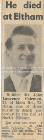
Newspaper - News Clipping, Herald, He died at Eltham. Herald, March 4, p3, 4 Mar 1965
John Lawrence Coleman (1934-1965) born January 10, was the son of Raymond John Coleman and Hanna May (Gillet) Coleman. He married Margaret Frances Dare in 1955 and was the father of two children. He died whilst attempting to rescue an older man trapped in the bushfire at North Eltham on March 3, 1965 He died at Eltham (Herald, 4 March 1965, p3) [Picture of John Lawrence Coleman] Builder Mr John Lawrence Coleman, 31, of Main Rd., Eltham, one of three men burnt to death yesterday in the fire at North Eltham. The other two were XXXXX, 33 who lives opposite the Colemans and Mr William Elwers, 64 of Batman Rd., Eltham. * * * Frank Martin was a volunteer with the Eltham rural fire brigade at the time of the 1965 bushfires which burnt Eltham North and Research. Frank was asked to assist with the removal of three bodies from the back gully (now Orchard Avenue). They were badly burnt and one was found stuck under a fence as though trying to escape. Volunteers John Coleman Jnr, William Elwers and George Crowe were killed trying to protect Eltham from bushfire – they were local heroes. At the time, John Coleman Jnr was survived by his wife Margaret and two young children – John 11 and Vicky 2. Margaret Coleman lived in the family home until 1992 when she sold it and moved to Tasmania to be close to her son. She died in 1997 aged 65 years. 75 yr old Ken Gaston grew up on Edendale farm, which was originally a poultry farm but is now owned and run by the Shire of Nillumbik as an educational farm for schools and visitors. He was Captain of the Eltham rural fire brigade in 1965 when John Coleman Jnr was burnt to death in the Eltham North bushfires serving as an unofficial volunteer. He was able to draw where the original Wattletree Road was and at the time was verified with the location of some remaining bitumen and a post from the original bridge over the Diamond Creek located near the junction of the Diamond Creek and another small creek which is further down from Research or Christmas Creek as locals refer to it. The original Main Road ran behind Colemans before the railway line was built beyond Eltham in 1912. (Information recorded by Harry Gilham, President EDHS c.2011) * * * Bushfires rage in Victoria, Snowy: Three dead (1965, March 4). The Canberra Times (ACT : 1926 - 1995), p. 1. Retrieved May 19, 2022, from http://nla.gov.au/nla.news-article131758981 Includes two photos of the fire in North Eltham “Firemen make for safety as fire rages in Upper Glen Park Road, North Eltham, Victoria. The smoke hides a house.” and “A house explodes into flames at North Eltham, Victoria. Firemen said bottled gas went up.” Canberra Times (ACT : 1926 - 1995), Thursday 4 March 1965, page 1 ________________________________________ Firemen make for safety as fire rages in Upper Glen Park Road. North Eltham. Victoria. The smoke hides a house. A house explodes into flames at North Eltham. Victoria. Firemen said bottled gas went up. Bushfires rage in Victoria, Snowy: Three dead MELBOURNE, Wednesday.—Three people died today in a bush» fire which raged through North Eltham, about 15 miles from Melbourne. The victims were three men. A fourth man is feared to be dead. Another bushfire. sparked off by the heatwave sizzling over south-eastern Australia, is burning out of control in the Kosciusko State Park, in the Snowy Mountains. Firefighters fear that if it reaches pine forests up the Yarrangobilly River, they will be powerless to stop it. The three victims of the North Eltbam fire were trapped by flames in a valley. Their bodies were found only a few yards apart. They were named by police tonight as Mr. George Crowe, 78, of North Eltham, William John Ewers, 64, and John Laurence Coleman, 31, both of Eltham. The other two have not been identified. They are believed to be a man aged about 40 and an 18-year-old youth. At least 12 homes were destroyed by the fire, the worst in Victoria since 1962, when eight lives were lost and hundreds of homes burnt down at Warrandyte. At one time the township of Eltham was threatened, but a cool change swept in from the south and held back the wall of flames. More than 100 dogs, worth about £4,000, died when the fire raced through two kennels in Short Street, Eltham. and Upper Glen Park Road, North Eltham. A trickle of water Residents ran into the streets as the blaze raced towards their houses. Others frantically dug firebreaks around their homes. Mrs. Sue Recourt wept when firemen arrived while she was vainly trying to stop the flames with a trickle of water from the garden hose. A stack of firewood was blazing, but the firemen managed to save the house and rescue four goats. Many homes in Eltham were saved after flames had crept to within feet of their fences. Students at North Eltham State School had to be evacuated when the blaze threatened the building. Fire fighters were severely hampered by lack of water and narrow roads. The blaze, which began in above century heat, turned toward Wattle Glen, where two houses were gutted. Then the flames raced towards Hurstbridge to the north. Firemen battling desperately, controlled the fire late this afternoon. Five forest fires were still burning in Victoria tonight. IN VICTORIA THIS WEEK Tragic lack of central fire authority (1965, March 9). The Canberra Times (ACT : 1926 - 1995), p. 2. Retrieved May 19, 2022, from http://nla.gov.au/nla.news-article131759928 Canberra Times (ACT : 1926 - 1995), Tuesday 9 March 1965, page 2 ________________________________________ IN VICTORIA THIS WEEK Tragic lack of central fire authority From Rohan Rivett It was the worst week for Victorian fire fighters since Black Friday 27 years ago. On that day one pilot up in a spotter plane said afterwards: "It seemed at times that half the State was on fire." This time, for three days on end, Gippsland men, women and children had moments of conviction that their towns would have blackened into anonymity before the weekend was out. The week began with horror at Eltham on the North-eastern edge of Melbourne. Eltham today is something of an artists' colony. Oil painters, water colourists, potters and sculptors proliferate. A number of University folk have emulated the example of Professor MacMahon Ball who pioneered the way by moving to Eltham and carving a home out of the bush in the thirties. Innermost Eltham is barely 14 miles from the G.P.O. Farthest Eltham stretches miles beyond. It served to illustrate the tragi-ludicrous truncation of Victoria's fire control. Part of Eltham is under the protection of the Melbourne Fire Brigade. But this responsibility ceases at some invisible and incomprehensible line — apparently determined by the meanderings of the water mains. At this point everybody's property throughout the rest of Eltham is dependent on the Country Fire Authority. Half an hour before midday on Wednesday, a fire suddenly started on the West side of Upper Glen road on the edge of Eltham. Before the fire brigade could arrive, it was burning on a widening front through timber and high grass north of Eltham. Two wind changes in rapid succession saw the fire leaping Diamond Creek. With a freshening wind it struck home after home in three streets. More than one of them exploded suddenly as if hit by an incendiary bomb. There is no piped gas in the Eltham area, hence many housewives use bottle gas. The flames outside caused the bottles to explode. Altogether twelve homes were completely incinerated and four more were badly damaged. Thirty prize dogs perished. About three hours after the fire started it raced suddenly down a gully hillside trapping an elderly man. Two other men apparently raced to the rescue. Flames caught the three men within yards of each other, not 200 yards off the Upper Glen Park Road where safety lay. They were burned to death. Next evening an angry and convincing secretary of the Fire Brigade Union, Mr. W. M. Webber, came on television and appealed to the people of Victoria to end the ridiculous and dangerous dualism in fire-fighting control. The Eltham fire, he said, had precisely illustrated the situation. The Metropolitan Fire Brigade area touched Eltham, but where the fire had gutted and killed, was just outside its area. Mr. Webber said his union had constantly urged one authority for the State with a complete reorganisation of fire protection. On Wednesday the union had repeated its call for an inquiry into fire protection in Victoria to the Chief Secretary, Mr Rylah. "No matter how close the liaison between the two organisations, there are always divided sections of thinking," Mr. Webber told viewers. "I don't know how much tragedy the com-munity can take before it demands that it is properly protected." Rumours that differences in gauge between taps and hose nozzles (as between the two authorities) accentuated the damage were denied by fire chiefs who said that all appliances were now carrying adaptors so that hoses could be linked to mains everywhere. But there is grave concern in the Metropolitan Fire Brigade's higher councils at the action of several Federal authorities with projects in and around Melbourne. They are installing non-standard equipment without reference to the State authorities or any dovetailing of appliances and equipment. Public alarm was not diminished by the publication on Friday and Saturday of a heart tearing letter from the young widow of John Lawrence Coleman, 31 year old father of two, who had died in the flames apparently trying to rescue the old man trapped in the gully. By that time, a Vast area of Gippsland was in flames and the troops had been sent in to back up the overworked and often helpless fire-fighters. By Saturday, the Leader of the Opposition, Mr. Stoneham, who has previously demanded a Royal Commission into fire-fighting arrangements, repeated his demand. To add to the Chief Secretary's worries he was publicly rebuked for allegedly implying on television that lives had been lost at Eltham because people went to the wrong place at the wrong time. In a letter to the Press, Professor MacMahon Ball pointed out that two of the men involved were experienced bushmen who had gone "to help an old man in great danger fully aware of the danger to themselves". As Victoria faced its sixth day of total State-wide fire ban, it looked likely that even official resistance was not going to silence the demand for one central authority to control the fire fiend. At the moment, the 400 square miles where two million Victorians live in Greater Melbourne are divorced from the rest of the State in planning, communications, equipment and control of personnel. No one doubts the whole-hearted co-operation and willingness to back each other up of the M.F.B. and the C.F.A., both at top-level and among the firemen themselves. However, when a city straggles so deeply into the country side, the absence of a single authority, to oversee and analyse the fire threat as a whole, suggests suicidal policy of divide and fuel. Emphasis of the tragic loss of a member of a pioneering family who died whilst helping others in his communitybushfire, cfa, country fire authority, fire brigrade, glen park road, heroes, john lawrence coleman, north eltham, victorian bushfires - 1965, volunteers, william john elwers, fire fighter, frank martin, george john crowe, ken gaston, orchard avenue -
 Eltham District Historical Society Inc
Film - Video (VHS), IMP Productions, The Shire of Etham - The Evergreen Shire (Series 69, Item 4), c.1985
Shire of Eltham Archives: Series 69, Item 4 This video was produced for the Shire of Eltham by IMP Productions and provides a description of the shire, 277 square km on a north/northeast axis, some 25 km northeast of the centre of Melbourne with a population of around 40,000. Scenes include Yarra River, rural settings and urban settings, housing estates, Shillinglaw Cottage, Pigeon Bank at Kangaroo Ground, the Eltham Railway Trestle Bridge with reference to the fight by locals in the 1970s to save it from replacement, Montsalvat, mudbrick making and its use as a building material, the use of mudbrick in the Eltham Community Centre blending harmoniously with the environment. Emphasises people living in the area due to the qualities of life provided. Also the Living and Learning Centre, St Andrews Markets and other local markets, the Eltham Leisure Centre, cricket and horse riding at Eltham Lower Park, the Infant Welfare Centre (part of the Eltham War Memorial), how residents are mindful of protecting their historical heritage, the CBA bank and Allwood House at Hurstbridge, Tracey Naughton about the Eltham "As we are" Community Banner project and the “River of Life banner”, the Parks and Gardens office in the former Police Residence building (now the Local History Centre), Alistair Knox Park, road planning and types of roads, tree canopy, Peck's Dam, green carparks, road drainage, Gordon Ford's garden and natural landscapes, and Were Street shops in Montmorency. Planning for shopping facilities and carparks with a population of 40,000 growing to 55,000, Arthur Street Mall and carpark, local village feel in the shopping centre. Councillors and Council staff featured include Mary Grant, Bob Manuell, Rodney Roschellor, John Cohen, Alan Baker. Also scenes of Commercial Place, Diamond Valley Railway, Eltham Galley, Riverclay and canoeing on the Yarra intermingled with images of the shire from the Shire of Eltham Pioneers Photograph collection.VHS Video cassette Converted to MP4 file format 00:11:56; 79MBshire of eltham, video recording, shire of eltham archives, alistair knox park, allwood house, arthur street, arthur street mall, bob manuell, canoeing, carparks, cba bank, commercial place, council staff, councillors, cr. mary grant, cricket, diamond valley railway, eltham community banner project, eltham community centre, eltham galley, eltham leisure centre, eltham living and learning centre, eltham lower park, eltham railway trestle bridge, eltham war memorial, gordon ford garden, horse riding, housing estates, hurstbridge, infant welfare centre, john cohen, kangaroo ground, local history centre, montmorency, montsalvat, mudbrick, parks and gardens, peck's dam, pigeon bank, police residence, river of life banner, riverclay, road drainage, road planning, rodney roschellor, shillinglaw cottage, shire of eltham pioneers photograph collection, st andrews market, tracey naughton, tree canopy, were street, yarra river, alan baker -
 Eltham District Historical Society Inc
Slide - Photograph, Aerial Photo (c.1987): Main Road, Eltham from Pitt Street to Elsa Court, c.Aug. 1990
Part of a presentation, "Roads and Byways of the Shire of Eltham", by Russell Yeoman to the 12 September 1990 Society meeting. Slides shown included copies of old photos and recent images ranging from the suburban streets of Eltham and Montmorency to the mountain roads of Kinglake. In the byways category are views of some iof the Shire's bicycle paths including then recently completed sections of the Main Yarra Trail at Lower Plenty.35mm colour positive transparency (1 of 37) Mount - Agfachrome Agfa CS System black 8 dotsinfrastructure, roads, aerial photographs, alistair knox park, bridge street, central park, diamond street, elsa court, eltham, eltham common, eltham railway station, eltham town park, main road, pitt street -
 Eltham District Historical Society Inc
Slide, Sherbourne Road overpass, Briar Hill, c.Oct 1970
... overpass railway bridge sherbourne road Para Road Road Construction ...Construction of new realigned Sherbourne Road railway overpass following realignment construction works for intersection of Sherbourne Road and Para Road.35 mm colour positive transparency Mount - Agfacolor Service (Blue)briar hill, bridge construction, overpass, railway bridge, sherbourne road, para road, road construction -
 Eltham District Historical Society Inc
Slide, Sherbourne Road overpass, Briar Hill, c.Oct 1970
... overpass railway bridge sherbourne road para road road construction ...Construction of new realigned Sherbourne Road railway overpass following realignment construction works for intersection of Sherbourne Road and Para Road.35 mm colour positive transparency Mount - Agfacolor Service (Blue)briar hill, bridge construction, overpass, railway bridge, sherbourne road, para road, road construction -
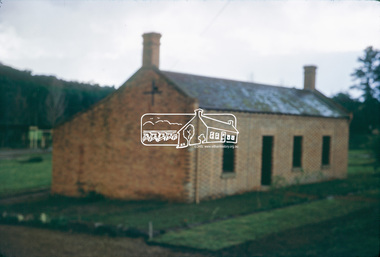 Eltham District Historical Society Inc
Slide, Shillinglaw Cottage, c.1973
Shillinglaw Cottage was relocated in 1963 from its former site a few hundred metres up Main Road to make may for new shire offices built in 1964. It was situated near the Eltham Railway Trestle Bridge on a site that was developed into the Eltham Common. The new Eltham Town Park was constucted opposite on the other side of what was to become Panther Place. In 1993/94 the new Eltham Library was constructed on the Eltham Common. This picture, though out of focus still gives a reasonable impression of the cottage at the time.35 mm colour positive transparency Mount - Kodak Kodachrome Cardeltham common, shillinglaw cottage -
 Eltham District Historical Society Inc
Slide - Photograph, Eltham Town Park, c.May 1988
In 1981 the Shire of Eltham Historical Society was asked by the Victorian Place Names Committee to comment on a proposal by the Shire of Eltham to assign names to parklands in Eltham as follows:- "Eltham Common" - the area between the municipal offices, Main Road, the Eltham railway -line, and Panther Place and containing Shillinglaw Cottage. The Shire has advised that this name has been used locally for the site since about 1975. "Alistair Knox Park" - the area bounded by the Eltham railway -line, Panther Place, Main Road, Bridge Street, and Susan Street, and through which flows the Diamond Creek. The area has been known locally as "Eltham Town Park" The proposed name "Alistair Knox Park" had created some local controversy with a number of reversals of the Council's decision and letters to the local paper both for and against the proposal. The society was reluctant to be drawn into this controversy particularly as there were known to be members with strong views both for and against the proposed name. The society appreciated the work done by Alistair Knox both in the formulation of the park concept and in its development but because of the controversy generated by the proposed naming and also because of the wide general use of the park by the public·, the name Eltham Town Park was felt more appropriate. The society noted that there was no outstanding historical associations with the land comprising the park which would warrant naming the park after any particular person, place or event. No objection was raised to the Eltham Common proposal as set-out above. The decision was made in the knowledge that Alistair Knox had been associated with the society over many years and was a prominent figure in the recent history of Eltham. He was regarded as a key figure in the environmental building movement and in particular was renowned for his use of mud bricks as a building material. He served as a councillor of the Shire of Eltham from 1971-1975, his final year as Shire President. It was during these years that the proposals to create the park in its present form were shaped and Alistair played a leading part in the decision to make it a landscaped passive recreational park rather than a sporting area. The parklands comprise a section of the Diamond Creek valley. The creek itself flows through the centre of the area which is overlooked by steep hills on each side. The parks form part of the land purchased from the Crown in 1851 by J.M. Holloway and then subdivided into allotments and called "Little Eltham". While most of the area was subdivided into residential lots the creek valley was subdivided into lots suitable for small farms. Some further subdivision took place over the years and the whole of the parks now comprises eight separate titles. A list of some of the former owners has been compiled but exhaustive research on all owners has not been carried out. The ownership of one parcel has been traced back to when it was purchased from Holloway by John Hicks Petty in 1874, long after it was subdivided. Other families owning land within the area over the years included Lyon, Rees, Clark, Waterfall, Carrucan, Graham, Hill and Morant. The character of the valley area has remained rural while development occurred on each side. Early photos show the area as orchard and grazing land. In 1901 the railway was constructed through the area resulting in the timber trestle bridge across the Diamond Creek. which is an important feature of the park landscape. A memorial obelisk to the Eltham servicemen killed in World War 1 was erected at the south eastern corner of the park. The site is now within the intersection of Main Road and Bridge Street and the memorial was shifted in the 1950s to the Eltham R.S.L. clubrooms. Following the financial failure of the local sub-branch, the memorial obelisk was again relocated to the Eltham War Memorial building precinct in 2011. During the early 1960's the Council started purchasing the land which now comprises the parks. In the late 1960's the area to the east of the Diamond Creek was used as a garbage tip and filled above the flood plain of the creek. When this area was filled the tip was transferred to the west side of the creek. From the early 1970's the area has been progressively developed as a park for passive recreation with ornamental lakes, extensive tree planting and landscaping. The character of the valley before the days of the tip has been recreated and this has earned a Landscape classification from the National Trust, an unusual honour for a man-made landscape. The parks are not only attractive in appearance. The large number of people using them, particularly at weekends and holidays is evidence of their popularity and the foresight and careful planning of local residents, Councillors and Council Staff. 35mm colour positive transparency (1 of 23) Mount - Kodak EktachromeProcess Date MAY 88Meltham, main road, alistair knox park, eltham town park -
 Eltham District Historical Society Inc
Slide - Photograph, Wattletree Road Bridge, Eltham, c.1993
35mm colour positive transparency Mount - Black and Whiteinfrastructure, roads, eltham, eltham north, level crossing, main road, park west road, railway crossing, sign, wattletree road, wattletree road bridge -
 Eltham District Historical Society Inc
Binder, Eltham District History, Eltham Road Board, 1856-1871; Research by Keith Chappel, 1971-1974
Eltham District History, Eltham Road Board, 1856-1871Two binders containing 486 A4 pages (photocopied) of mostly handwritten notes from research undertaken of Public Office Records of Victoria various holdings. Some photocopies from source reference books. Includes 20 page subject index (handwritten) at front and 5 pages of notes and sources at rear and a photocopy of short biography of Keith Chappel.a. foley, a. harkness, a. mackie, a. mcintyre, a. von ziegler, a.a. vivian, a.d. kinninmont, a.d. quadri, a.h. grimshaw, a.w. page, aboriginal reserve, aborigines, abraham quarman, abraham rooks, abraham taylor, adam goudie, aenaes harrison, agnes black, agnes charlton, agnes dalrymple, ah chong, ah cock, ah hein, ah lie, ah sing, albert lunson, albert ness, albert parker, albert ramseyor, alert hunt, alex cameron, alex eason, alex mcandrew, alexander crichton, alexander donaldson, alexander falconer, alexander innes, alexander james, alexander mcdonald, alexander miller, alexander thompson, alexander walker, alexander white, alfred armstrong, alfred burgess, alfred davey, alfred deschamp, alfred eddy, alfred hinley, alfred hooper, alfred hubbard, alfred lowman, alfred smith, alfred whelpton, alice power, allen heeps, allwood, amelia neuman, amos taylor, anderson, andersons creek, andrew brown, andrew byrne, andrew harkness, andrew herbert, andrew ross, andrew smith, angus mcdonald, ann emmott, ann mcphee, ann odea, ann plunkett, ann snell, ann tatty, annie ashmore, annie herbert, annie stuart, anthony beale, anthony currie, ants nest, archibald mcphee, arthur connor, arthur lyttle, arthur rooke, arthur young, arthurs creek, arthurs creek school, august ostling, b.o. wallis, barkers creek, barr, belton, benjamin bain, benjamin jenken, benjamin lawford, benjamin rice, benjamin shaw, benjamin smith, benjamin wallis, benjamin walton, berry, bismark hotel, black calf gully, black thursday, boomers gully, bridget bunker, bridget hailes, bridget kearse, bruno hirt, burns, bushranger, c. twiss, c.h. bade, caleb sherar, caledonia, caledonia diggings, campbell hunter, carl euman, caroline davey, catherine kennedy, cathren brock, cecilia farman, chamberlain, chapman, charles caldwell, charles campbell, charles dale, charles draper, charles fowler, charles green, charles hawkins, charles hempel, charles hirt, charles hirtson, charles jefer, charles jesse, charles kerchevell, charles lidgerwood, charles morris, charles peake, charles prince, charles rielly, charles roberts, charles rowand, charles simms, charles souter, charles swan, charles verso, charles wells, charles whelpton, charles williams, charles wingrove, charles woodley, charleys gully, charlotte beltison, charlotte goodwin, ching ah hock, christine brennan, christine mckenzie, christmas hills hotel, christmas hills school, christopher battaila, christopher twiss, chune grove, church of england, church of england school, clarissa milton, cleir hills, colin amos, constable quirke, constable talty, cornelius haley, cornelius stewart, cottles bridge, councillors hotel, cricket, cucksons brewery, d. nicholson, d.w. morrissey, dalry, daniel charleston, daniel harding, daniel jepps, daniel mccarthy, daniel mckenzie, daniel mcloughlin, daniel oloughlin, david boyd, david christian, david clark, david creighton, david rogers, david rolfe, david sharp, david shawcross, david smith, david stevenson, diamond accommodation store, diamond reef mine, dickson, dixon bertram, donald cameron, donald mcmillan, donaldson, dougald mcphee, dr barclay, dugald mcphee, dugald taylor, duncan fraser, duncan smith, dungey, e. hildebrand, e. stichlins, e.f. falkiner, e.j. hughes, e.m. garsed, e.w. morrissey, edith staff, edmund clarke, edmund cuckson, edmund hall, edmund picket, edward bage, edward beltison, edward bunker, edward ford, edward hindley, edward jackson, edward jones, edward kelly, edward qualtrough, edward staff, edward tresain, edward weller, edward whelpton, edward whilpson, edwin biley, edwin cartwright, edwin cohen, edwin deschamp, edwin mcleish, edwin rodda, edwin smith, effie rodda, eliza bellamy, eliza dawson, eliza howell, eliza nield, eliza smith, elizabeth cockshutt, elizabeth eiles, elizabeth fitch, elizabeth gillespie, elizabeth harris, elizabeth herbert, elizabeth hollow, elizabeth le juge, elizabeth plunkett, elizabeth whelpton, ellen hurst, ellen kearse, ellen quarman, ellen sweeney, ellen white, ellis, eltham cemetery, eltham hotel, eltham lower park, eltham market, eltham police station, eltham pound, eltham quarry, eltham racecourse, eltham roads board, eltham school, emile hude, emily anderson, emily blamire, emily coutie, emma smith, emma taylor, ephraim wyett, ernest baillie, ernest henrick, ernest steer, esther porter, ethel baillie, evan jones, evelyn hotel, evelyn observer, ewen cameron, ewen jones, f. chrimes, f. grundel, f.e. falkiner, f.r. howard, fanny benson, fanny white, felix hude, felix noisette, ferdinand ramseyer, flora vale, florence hurst, fogarty, forbes mackenzie, fords creek, frances kearse, francis baker, francis hales, francis raselli, francis steer, frank eiles, frank rogerson, frank tanner, fraser, fred hurst, frederick falkiner, frederick hurst, frederick muller, frederick nink, frederick walker, frederick wharington, friedrich muller, fryers gully, furphy, g. donaldson, g. houghton, g. turnbull, geanetta hude, george assender, george bear, george beare, george benson, george bird, george boston, george brain, george brandt, george burley, george buswell, george coutie, george eiles, george ewings, george ford, george godber, george goodman, george gray, george griffiths, george hall, george herbert, george horn, george kirk, george langhorne, george mann, george mclelland, george mosely, george neumayer, george orchard, george parish, george porter, george purcell, george ralph, george reid, george rocke, george rogers, george rolfe, george stebbing, george stebbings, george stebbins, george switzer, george symons, george thompson, georgina hilton, glenda moriss, glengloy, gold, goulstone, greensborough police station, gulf station, h. jennings, h. mann, h.h. farquason, hannah sunderland, happy valley, harkness, harold scarce, harriet hunt, harriet smith, harry hollow, hazel glen, healesville, heinrich hirt, helena peters, henrietta hill, henry arthur, henry ashmore, henry austin, henry brown, henry dendy, henry dineen, henry fowler, henry gardner, henry green, henry griffin, henry hart, henry hirst, henry hirt, henry hopkinson, henry hude, henry hurst, henry inch, henry jones, henry mills, henry scarce, henry st paul, henry stevens, henry stooke, henry thomson, henry vogt, henry wallace, henry wilson, herbert rodda, herman henrick, hermann lampe, hermann steinmann, hester staff, hitchill, holbert, honoree hude, hotel de france, hugh mccann, humphrey peers, humphrey spicer, hurstbridge, hurstbridge general store, i.h. clarke, ida adelskold, ignatz kinzel, ira pimm, irene donaldson, isaac briggs, isaac hickson, isaac hill, isaac kerr, isaac varby, isaac williams, isabella donaldson, isabelle herbert, j. dungate, j. eccleston, j. harkness, j. hartley, j. hude, j. irvine, j. jones, j. manduell, j. mason, j. mcdonald, j. mcnamara, j. nichenson, j. renahen, j. scott, j. seymour, j.a. goold, j.a. panton, j.c. hughes, j.d. thompson, j.f. hughes, j.f. johnstone, j.g. walter, j.h. taylor, j.p. morris, jack ewart, jacob belsham, jacob goldstein, jacob morast, jam loon, james alexander, james anderson, james andrew, james andrews, james baines, james batchelor, james bond, james bradford, james brennan, james brock, james brown, james brunning, james buchanan, james cockburn, james cowan, james dalrymple, james donaldson, james duckworth, james goodwin, james harding, james harrison, james hartley, james hawkins, james hewish, james holinger, james hughes, james inglis, james jamieson, james johnson, james johnston, james kaye, james kew, james lindsay, james lindsey, james lynan, james macpherson, james mann, james martley, james mayger, james mccutcheon, james mcmahon, james mcpherson, james mess, james miller, james mitton, james morton, james murdoch, james murdock, james nickinson, james orford, james purcell, james qualtrough, james rudall, james simpson, james smith, james spence, james stonachan, james stuart, james suman, james surman, james sutherland, james thompson, james thomson, james walker, james walters, james watts, jane cleave, jane donaldson, jane mess, jane sadler, jane shaw, jane thomson, janefield, jean borelli, jeanette hudi, jeanne hude, johann muller, john ainsworth, john andrew, john baillie, john barr, john beale, john bell, john bellin, john blake, john blyth, john brock, john brown, john byers, john cameron, john candler, john carter, john cobbock, john cockshank, john cockshutt, john coleman, john connell, john crozier, john darroch, john dennis, john donaldson, john elsworthy, john fenton, john fitch, john gardner, john gast, john graham, john grimshaw, john haines, john haley, john harper, john harris, john hassall, john hayes, john heales, john herbert, john holland, john holman, john hood, john horner, john horton, john hughes, john jardine, john johns, john johnston, john jones, john kearse, john kilpatrick, john knell, john lawrey, john macadam, john mandell, john manduell, john marker, john mccoll, john mccolly, john mcdonald, john mcintyre, john mckimmie, john mcnamara, john mitchell, john moore, john morgan, john muller, john murray, john pearson, john peterson, john petty, john pullen, john quinn, john rawlings, john ryder, john sabelberg, john scott, john semar, john serman, john seymour, john shawcross, john smith, john staff, john steer, john stephens, john sweeney, john thompson, john thomson, john trahy, john walker, john weller, john wells, john williams, john williamson, john yates, john yeoman, john young, johnn mcdonnell, joseph bull, joseph burns, joseph caldwell, joseph caudwell, joseph coutie, joseph elliott, joseph emmott, joseph fayver, joseph furphy, joseph hall, joseph hibbert, joseph hilton, joseph johns, joseph lithgow, joseph panton, joseph rodda, joseph sands, joseph sanson, joseph schubert, joseph scott, joseph shaw, joseph smith, joseph spedder, joseph stevenson, joseph verco, joseph wilson, josiah hollis, josiah hullis, josiah thomas, judith furphy, julie williams, junction hotel, kangaroo forest, kangaroo ground, kangaroo ground cemetery, kangaroo ground general store, kangaroo ground hotel, kangaroo ground police station, kangaroo ground post office, kangaroo ground school, kate bolger, kath scarce, katherine kearse, kidd, kinglake, kinglake hotel, kingstown, l. storey, lan quan, lang, latimour, laura henrick, laurence paterson, leon berlioz, levinia henrick, lillian gillan, linton, little eltham, long gully, louis henrick, louis le juge, louis smith, louisa steinmann, louise miller, lower plenty bridge hotel, lucy tidell, lydia qualtrough, m.j. careton, m.s. adams, macrudden, maggs, mail coach, maplestone, margaret graham, margaret hollins, margaret kearse, margaret kennedy, margaret kinrade, margaret lynch, margaret mcbirney, margaret steinmann, marguerite borelli, maria reilly, maria st paul, maria trew, marian trew, marianne miller, marie wright, marion hillier, mark bunker, martha herbert, martin brennan, mary alexander, mary beltison, mary bradford, mary bridgman, mary brock, mary bull, mary eiles, mary hopkinson, mary kearse, mary lean, mary mcinerney, mary miller, mary parmington, mary pearson, mary pickles, mary robertson, mary rodda, mary ross, mary smith, mary surman, mary weller, matilda jordan, matilda mcmillan, matthias watson, mawson, mechanics institute, michael callanan, michael fenton, michael kearse, michael mctyne, michael merritt, michael oday, michael odea, midgley hall, mills, minnie watts, miss bellon, morgans gully, mount joy, mr donnan, mr omeare, mr page, mrs greenaway, mrs havard, mrs hude, mrs morris, muller, murrays bridge, n.d. whyte, ned kelly, new caledonia creek, nicholas rodda, nillumbik, norman mcphee, old caledonia gully, oliver gourlay, one tree hill, owen finnegan, panton hill, panton hill hotel, panton hill post office, panton hill school, parambool, patrick armstrong, patrick bourke, patrick burke, patrick callaghan, patrick green, patrick harrington, patrick kearse, patrick lynch, patrick mcintyre, patrick o'callaghan, patrick rodgers, patrick sheahan, peach grove, perinella bull, perry, peter carrucan, peter flyn, peter ford, peter lawlor, peter patterson, peter snodgrass, peter watson, philip korfman, phillip gakden, phillip kaufman, phillip korfman, pierce brennan, pierce power, poo long, pound bend, pretty hill, queenstown, queenstown cemetery, queenstown police station, queenstown school, r. mackie, r.a. davidson, rebecca noisette, rebecca weller, reefers hotel, research, research gully, research gully hotel, research hotel, research school, rev dobinson, rhoda coutie, richard brook, richard capper, richard dunstan, richard goulding, richard heales, richard lane, richard matthews, richard rodda, richard searle, richard smith, richard wallis, richard warren, richard woolcott, robert alice, robert bourke, robert burke, robert charlton, robert clarke, robert cunningham, robert dugdale, robert grant, robert hall, robert harris, robert hempel, robert hill, robert hurst, robert lowman, robert mcadam, robert mckee, robert nink, robert norman, robert pontessey, robert sharp, robert smith, robert steel, robert stevenson, robert strong, robert surnam, robert wood, robina joyce, rogerson, roman catholic church, rossiter, rudolph muller, ruth mess, ruth sadler, ruth stevenson, s. smith, s. stewart, salters rush, sam deacon, samuel bird, samuel brace, samuel cameron, samuel candler, samuel cole, samuel cracknell, samuel dagley, samuel flier, samuel furphy, samuel merriman, samuel moseley, samuel mosley, samuel smith, sarah howard, sarah moseley, sarah raston, sarah walters, second watery gully school, self, shin hun, simon armstrong, smiths gully, smiths gully mechanics institute, smiths gully school, sophia greenaway, spanish gully, st andrews, st andrews hotel, st helena, stack, stanley smith, stephen gonnet, stephenson turner, stephensons bridge, steven anderson, stevensons corner, sumner, susan dickson, susan street, susan walke, sutherland, t. davidson, t. mclaughlin, t. symons, t.a. aldwell, t.b. drummond, t.b. henderson, t.e. johnston, t.h. subelly, tarrawarra, theis, theodore sabelberg, theresa lynch, thomas anderson, thomas armstrong, thomas baillie, thomas batt, thomas bell, thomas benson, thomas bibbs, thomas boardman, thomas bradford, thomas bull, thomas cattery, thomas cochrane, thomas cook, thomas cottle, thomas cousins, thomas downward, thomas edwards, thomas evans, thomas grierson, thomas haines, thomas harmer, thomas hunniford, thomas huntford, thomas hurry, thomas jardine, thomas jones, thomas kearse, thomas kennedy, thomas marland, thomas martin, thomas mcinerney, thomas morrison, thomas mundy, thomas murphy, thomas murray, thomas peacock, thomas plunkett, thomas postlethwaite, thomas prior, thomas qualtrough, thomas smith, thomas stone, thomas sunderland, thomas swatling, thomas sweeney, thomas symons, thomas walke, thomas wall, thomas wright, thomas young, tim shaw, toll gate, tom collins, tommys hut, true, upper diamond creek, upper diamond creek school, view hill, virtue hall, w. cockayne, w. craig, w. foster, w. marriott, w. ridley, w. trenoweth, w.a. page, w.b. andrew, w.b. burnley, w.b. phillips, w.c. shortt, w.w. herbert, walter barlow, walter hillier, walter joyce, walter knell, walter mckimmie, walter mcnicoll, walter thomson, walter wippell, warburton carr, warrandyte, warrens hotel, watery gully, watsons creek, watsons creek hotel, wattle glen school, wellers hotel, weymss donaldson, whipstick gully, white cloud, wild dog creek, wild dog gully, wiliam albert, william aitken, william albert, william anderson, william andrews, william barr, william barrow, william bell, william bond, william bowden, william bremmer, william brewer, william bridgman, william burnley, william buswell, william cant, william clarke, william cleave, william crozier, william dawson, william dodging, william ellis, william finn, william fitzgibbon, william ford, william foster, william garland, william ghosley, william golding, william goodwin, william graham, william gray, william grimshaw, william hall, william harding, william herbert, william hoilett, william hopkinson, william howitt, william howlett, william hubbard, william hunt, william inglis, william jarrold, william joyce, william kidd, william kilpatrick, william kommer, william lodge, william mclaughlin, william mcmurray, william mitton, william moore, william mosley, william murphy, william nicholson, william normage, william norman, william nuttall, william phillips, william quarman, william ronald, william sadler, william scott, william seaville, william sharp, william smith, william spicer, william taylor, william thomson, william tobin, william underwood, william walsh, william walshe, william walters, william watkins, william west, william wilmot, william wilson, william wolverston, william woods, wolfe, woodley, yarra bank, yow yow creek, a. brewer, a. easson, a. edwards, a. melville, a.m. ross, a.r. larrimour, aborigine reserve, advertisements, agricultural district, alan bernhard horsley, albert frederick charles glover, albert h price, albert h.c. price, albert henry charles price, alex easson, alexander campbell, alexander melville, alexander thomas haley, alexander thomson, alfred j. lowman, alice may peake, alie haley, alistair knox, alistair samuel knox, allandale road, allendale road, allwood run, andrew, andrew mckay, anton william brinkkotter, archibald brown, argus, arthur chichester allen, arthur edwin cracknell, arthur john braid, arthur robert traynor, atlas of australia 1886, b. lawford, b. mess, barry thale houston, basil y hall, basil yaldwyn hall, bell street, benjamin baxter, benjamin bowater, benjamin thomas taylor, benjaomin o. wallis, bible street, billis, bolton street, brewery, brisbane street, buckingham, bushrangers, c. brown, c. carroll, c. hirt, c.s. haley, c.s. wingrove, c.t. harris, caledonia run, cam, cattle, charis meta alexander pelling, charles brown, charles ellis, charles hicks bath, charles newman, clara gonnet, claude bryan gibbs, clifford henry goulding seear, coleraine, colin t. bell, collectors, collingwood, commissioner airey, coplin thomas bell, cornelius john stewart, cornelius sharp haley, cornelius sharpe haley, county of evelyn, culla hill, cutto hill, d. ryan, daily news newspaper, dalton street, daniel jepp, derek cecil o'beirne, diamond creek, diamond creek post office, diamond creek railway station, diamond creek run, diamond creek station, diamond creek township, divisions, doctor, donald alfred neil, donald charles maling, donald ingersole, donald kennedy, douglas anderson, e. cameron, e. falkiner, e. stooke, e.t. peers, edward dumaresq, edward heller, edward james, edward wilson, edwin stooke, elections, electoral districts, electoral roll, electrified railway, eltham, eltham district description, eltham district history, eltham district road board, eltham post office, eltham railway station, eltham road district, eltham road district board, eltham shire council, eltham shire councillors, eltham shire history, eltham town common, eltham village, eltham-hurstbridge railway, ely street, eric dudley butler, eric nichol staff, eric percival harmer, ernest james andrews, eve may edwards, evelyn and mornington division, evelyn division, everard albert hale, ewn hugh cameron, f. stone, f.d. wickham, flour mill, fountain of friendship hotel, francis bradley, francis joseph favier, francis regiereals(?), francis watson rosier, frank haley, frank wayne maas, franklin william nankervis, frederick charles barrett, frederick edward falkiner, frederick eldred griffith, frederick filed durham, frederick gration, frederick kirk gration, frederick vincent squire, fredrick ninck, g. drabble, g. haley, g. hodgkins, g. lee, g. thomas, g. thomson, g.d. boursiquot, g.f. belcher, garden hill, geoffrey charles dreverman, geology, george d'arley boursiquot, george ellis parker, george fletcher, george frederick belcher, george haley, george hirt, george louie cresp, george love, george robertson, george turnbull, george wise, godalmin street, gold mining, goodman, gordon melville, government gazette, graham lindsay bride, grazing, greenhill, greensborough, grierson, gun maker, h. g. james, h. stooke, h. taylor, h.g. jhones, h.t. beams, harold edward bartlett, heatherleigh, heidelberg, helen louise wells, henry creswell, henry gilbert jones, henry holloway, henry peers, herbert eric rundle, herbert hewitt, herbert rutter, hoddle, holiday resort, horace hilton, house of assembly, hugh larimour, hurst, i. barrow, i. rooks, ian g smedley, ian gordon smedley, industry, isaac rooks, isidore t. wilmor, j. alison, j. brown, j. cameron, j. carfrae & co., j. ferguson, j. frank, j. garthwaite, j. greaves, j. greitzner, j. irish, j. lindsay, j. murray, j. o'brien, j. stevenson, j. wilson, j.b. phipps, j.b. rodda, j.f. imley, j.g. foxton, j.g. fraser, j.h.f. hawke, j.k. zahn, j.m. holloway, j.p. imley, jack cato, jack clendinnen gill, jacob belcham, jacob greitzner, jakeb greitzner, james bailey, james cox, james d mealy, james darley mealy, james frank, james frederick mackay, james graham, james johnstone, james kay bryce, james mclaren, james murray, james oliver white, james pearson imley, james pearsons imley, james rosier, james ryan, jane thompson, jersey, johann karl zahn, john a porter, john alexander hampton lewis, john alison, john b. wilson, john barter bennett, john blackmore phipps, john blakemore phipps, john carfrae, john dane, john g. foxton, john gerald searle, john greaves, john green foxton, john greenlaw foxton, john henry sabelberg, john johnstone, john lee smith, john lindsay, john lindsay beale, john mann, john mason, john pape, john porter, john samuel lithgow, john stevenson, john verran mcconnell, john wilson, jonathan scott, joseph anderson panton, joseph bromley shallard, joseph garthwaite, joseph smedley, joseph walter henry bradbury, josiah morris holloway, k.e. dunstan, m kinglake, keelbundora, kenneth chareles crompton, kenneth donald macmillan, kenneth frederick hines, kenyon, kerby street, kinglake school, krelbundora, l. jenyns, l.m. bill, lancefield, land act 1862, land act 1865, land act 1869, land alienation, land settlement, legislative council, leopold kershaw lawry, leslie christopher docksey, leslie edward clarke, little eltham school, m. o'shea, m.h. fitzpatrick, mail run, mail service, main road, map, margaret moody, martin fogarty, mary leak, maxwell alexander spence, medical practitioner, michael o'shea, miss haley, moira, morang, mr. ford, mrs galbraith, n. gillies, n. rodda, name, names, neil stewart roberts, norman ernest charles williams, opening, orchard district, p. ryan, p.a.c o'farrell, p.p. cotter, parish of nillumbik, parish of nillumbik 1856, patrick costello, patrick turnbull, percy downer, peter andrew charles o'farrell, peter fair, peter graham, petr lawlor, phillip cumming, photographer, plenty river, polling place, polling places, porter street, portrait, post office, post office directory 1868, princes bridge, proclamation, r. boston, r. hepburn, r. lane, r. wadeson, r.d. mess, r.s.h. moody, radley (rodney) douglas quin, rag mill, railway lines, raymond clive duncan, registrar, research state school no. 2959, reserve for aborigines, reynolds road, richard jones and co, richard robert woolcott, river plenty, robert alan bell, robert benn (ship), robert cadden, robert cunningham white, robert david taylor, robert hepburn, robert kenneth marshall, robert miller, robert reid, robert stewart hull moody, robinia joyce, rodda family, rosemount, rupert norman maskell, ryans road, s. evans, s. wekey, samuel evans, samuel phillips, samuel ramsden, samuel w. scott, searle, shire of diamond valley, sigismund wekey, sly grog seller, sources, south province, south yarra, st kilda, stanley simpson addison, strathbogie, strippers of bark, stuart alexander donaldson, sweeneys lane, sweeny, sylvia ruth houston, t. archer, t. huntley, t. murray, t. stephens, t. watkins, t.a. stork, t.b. daling, t.b. darling, t.c. darling, t.milthorpe, t.p. cross, tannery, tenders, terence alphonsus collins, the explorers and early colonists of victoria, the story of the camera in australia, thomas bell darling, thomas clarke, thomas darling, thomas foster chuck, thomas grant, thomas henry bowman, thomas herbert power, thomas irvine, thomas maltby, thomas mccombie, thomas scarce, thomas sweeny, thornton street, town of eltham, vaccinations act, victorian government gazette, virtue hall station, virtue hill, w. archer, w. brown, w. gordon, w. inglis, w. jones, w. matthew, w. mcdonald, w. williams, w. wilson, w.r. belcher, w.t. fitzpatrick, walter craig, walter wipple, warringal, water wheel, wattle glen, whittlesea, william acland, william adams, william b. burnley, william buckingham, william c. farrell, william cleve, william craig, william frederick ford, william george gray, william henry hull, william john taylor, william john turner clarke, william johnson, william jones, william lorimer, william morris, william redmond belcher, william thomas cochrane, william vasey houghton, william walker, william wandliss herbert, william white, willie haley, willie stanley dawson, yan yean, yarra flats, yarra river, yielima, york street, yow yow gully, zig zag road, frederick george hurst, grimshaw, mrs s marshall, mrs mcclelland, bushfire