Showing 7671 items
matching road building
-
 Whitehorse Historical Society Inc.
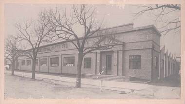
Document, Nunawading South State School
... . Photocopies of photos of the land before and during building. Road... and during building. Road Plan. Notice from Native Plants ...Documents relating to purchase of land to build Nunawading South State School. Land purchased from K.E. & L.A. Jones. Photocopies of photos of the land before and during building. Road Plan. Notice from Native Plants Preservation Society.nunawading south state school no. 4808, k.e. & l.a. jones, victoria. education department, native plants preservation society of victoria -
 Sunbury Family History and Heritage Society Inc.
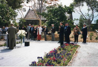
Photograph, Veronica Burgess, Rose Garden opening, 12 December 1999
... Bulla Roads Board building. St. Mary's Church of England... Bulla Roads Board building. St. Mary's Church of England ...The Mayor of Hume City Council, Jack Ogilvie, was addressing local 12th December 1999 in the grounds of the former Bulla Roads Board building. St. Mary's Church of England is adjacent to the Rose Garden. Alister Clark, a former Bulla resident and a rosarian, developed many different species of roses at his Glenara property. The garden in Bulla has been erected in his memory.Alister Clark developed many rose varieties that could withstand Australia's climate. Many of them, such as the Lorraine Lee, have become a popular addition in gardensA non-digital coloured photograph of a man standing in front of a lectern addressing a group of people who are standing in a garden. A small bluestone church is on the adjacent property.alister clark, 'glenara' homestead, bulla, alister clark memorial rose garden, roses, jack ogilvie -
 Lakes Entrance Historical Society
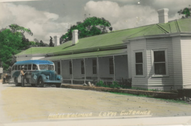
Postcard - Kalimna Hotel, 1955c
... side of main building, Hotel Road Kalimna Victoria... building, Hotel Road Kalimna Victoria Kalimna Hotel Postcard ...Kalimna Hotel built 1884 to 1885 by Thomas Laughton on land previously leased by Peter Egan FishermanTinted postcard of Kalimna Hotel showing a Pioneer Tourist Coach parked at the front with glimpse of Beer Garden on Western side of main building, Hotel Road Kalimna Victoriabusinesses, hotels -
 Halls Gap & Grampians Historical Society
Photograph
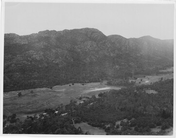
... . A road and some buildings can be seen where the cleared land... dense treed area in the foreground. A road and some buildings ...Photo depicts Fyans Valley. The road is The Grampians/ Dunkeld Road, leading to Dunkeld towards the right or Halls Gap travelling towards the left. Fyans Creek is visible in parts at the foot of the range (middle of Photo). Photo appears to have been taken from Bellfield Pk area. Photo is typical of those taken by Forests Commission of Victoria in the 1960sPhoto shows a mountain range in the background with a valley. The Valley has a band of a mostly cleared grassy section (middle of photo) with a fairly dense treed area in the foreground. A road and some buildings can be seen where the cleared land meets the treed area.scenery, fyans valley -
Port Melbourne Historical & Preservation Society
Banner - Port Melbourne Citizens Action Group, Citizens Action Group
... and building of road through Railway Reserve...., the SCDC Bayside development, Council amalgamations and building ...Made during the group's campaigns against the loss of railway, the SCDC Bayside development, Council amalgamations and building of road through Railway Reserve.Banner reading 'Port Melbourne Citizens Action Group Fighting for your Rights' '*Market redevelopment * Station Pier *Light rail *Freeway *Your Council' Hand painted onto flannel sheeting in back, purple, red, green and blue; edges hand-boundpublic action campaigns, societies clubs unions and other organisations, town planning - proposals shelved - bayside, ian mckay, citizens action group -
 Vision Australia
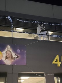
Photograph - Image, Deb Hallmark, 2022 Christmas decorations at Kooyong, 28/11/2022
... on the Glenferrie Road side of the building at Kooyong.... on the Glenferrie Road side of the building at Kooyong. Vision Australia ...To celebrate Christmas and advertise Carols by Candlelight, the property team put up a number of external decorations on the Glenferrie Road side of the building at Kooyong.5 images of reindeer lights and banners displayed for Christmasvision australia, carols by candlelight -
Glenelg Shire Council Cultural Collection
Photograph - Photographic print - Weatherboard building, c. 1970
... on road outside weatherboard building. Victoria Hotel, west side... Norfolk pine in treeguard on road outside weatherboard building ...Photographic print of a rephotographed photograph. Image shows a weatherboard building with 2 attic windows, next to a single storey stone building. Small Norfolk pine in treeguard on road outside weatherboard building. Victoria Hotel, west side Percy Street, between Tyers and Fern Streets. -
 Bendigo Historical Society Inc.
Photograph - HANRO COLLECTION: KNITTING MILLS PTY LTD
... of building on road side.... of building. Bare trees in front of building on road side. Photograph ...Black and white photo: Hanro Knitting Mills, Hargreaves Street Bendigo. Large brick building with entry doors on either end of front of building. Bare trees in front of building on road side.Bartlett Bros. Bendigoorganization, business, hanro knitting mills -
 Melbourne Tram Museum
Photograph - Block Mounted Photograph, Surrey Hill Neighbourhood Centre, 1926
... in the top right hand corner of Whitehorse Road Balwyn, looking east...Melbourne Tram Museum 8 Wallen Road Hawthorn melbourne ...Photograph - mounted onto a heavy card, numbered 65-575 in the top right hand corner of Whitehorse Road Balwyn, looking east from near corner of Balwyn Road in 1926. Notes that the image is courtesy of the TMSV. See image i2 for the actual photograph. 4673.1 - loose print of the photograph with the words on the rear: "Melbourne / Whitehorse Road, eastwards at Balwyn Road, Balwyn (Building at left with domed tower is on north west corner). Probably early 1930's.On rear in ink "Copied for Keith Kings, Nov. 2002" and the "Surrey Hill Neighbourhood Centre" stamp.trams, tramways, whitehorse road, balwyn -
 Buninyong & District Historical Society
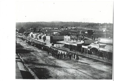
Photograph - B/W photograph, Procession marching down Warrenheip St. towards Learmonth St, 1901, Original photo 1901
... beyond photograph, building along road, scattered houses..., then brass band and marchers extending beyond photograph, building ...Procession to celebrate opening of new rotunda in Buninyong Gardens, dedicated to Queen Victoria who had died January 1901.B/W photo, Street view, from hotel balcony, procession led by man on horseback, then brass band and marchers extending beyond photograph, building along road, scattered houses and ridge beyond.:Procession on Warrenheip St. for the opening of the Rotunda in the Buninyong Gardens, 1901. Arthur Coxal Mayor leading.buninyong, warrenheip st, procession, arthur coxal, brass band -
 Eltham District Historical Society Inc
Negative - Photograph, Peter Bassett-Smith (poss), Shire of Eltham Office and Hall, cnr Main Road and Arthur Street, Eltham, c.1961
... of Arthur Street and Main Road, Eltham. The Building also incuded... of Arthur Street and Main Road, Eltham. The Building also incuded ...Eltham Shire Offices 1941-1965, were located at the Corner of Arthur Street and Main Road, Eltham. The Building also incuded a community hall. A 1961 EK Holden Special Sedan is parked in Main Road. Victorian registration HKF-296 was issued in 1961.Negative black and white film 120 6x6 format One of six frames (sectioned: three continuous, two single frames and one frame missing), and Associated black and white photo printeltham, main road, arthur street, council, eltham hall, eltham shire council, eltham shire hall, eltham shire office, shire of eltham, 1961 ek holden special sedan, motor vehicles -
 Emerald Museum & Nobelius Heritage Park
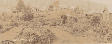
Photograph, Early postcard, Emerald Victoria, 1909
... Road. Depicts 7 buildings, 6 identified as follows from right..., Emerald; now called Emerald Gembrook Road. Depicts 7 buildings, 6 ...Formally Main Road, Emerald; now called Emerald Gembrook Road. Depicts 7 buildings, 6 identified as follows from right to left: Abbatoir, Cooper's Butcher, Andrew's General Store, Madigan's Bakery, Archilbald & Moffatt Grocery and Bakery, Walter's Barber Store1909 photograph of the commercial district in Emerald, Faded sepia postcard depicting Emerald Main Street, Commercial District (1909)Front: Emerald Victoria Handwritten on Back: Dec. 1909 (pencil); 'Wishing you the compliments of the season, hoping you will drive over some day and see how we are getting on. From RJ....? Emerald. To: Rev'd Whiteside, Beaconsfield Railway Station. Vicemerald, commercial district -
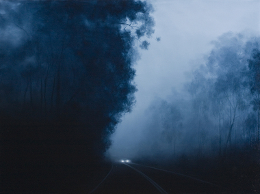 Nillumbik Shire Council
Painting: Camilla TADICH, Camilla Tadich, 6.23am Kangaroo Ground, 2009
... , vegetation, road, vehicles and buildings. She uses photographs... and the nature of surfaces, vegetation, road, vehicles and buildings. She ...Tadich spends time observing night time phenomena, the light from the moon, street lights and other sources; atmospheric states, fog and dampness and the nature of surfaces, vegetation, road, vehicles and buildings. She uses photographs and sketches before settling on the final idea for a work.This painting is typical of Tadich's recent work. She continues her exploration of the Australian landscape (most often the local, Nillumbik Shire). It is 'a dramatic interplay between narrative, landscape and the binaries of light/dark and the known/unknown of local landscape. The swathes of darkness within the work(s) pose questions about our inscribed fears and tensions, both cultural and existential'. (catalogue, 'Silent Space' Ex. 2006) Tadich's early experiences of fireworks, simple fireworks and bonfire in the surrounding bush of her outer Melbourne home, caught her imagination. She was inspired to investigate the issues surrounding nights in the bush. In this painting the narrative is ambiguous, the pinpricks of light, in this case from the car headlights provide a critical element. We can distinguish familiar features, a road, trees and a car that suggest human presence. However, what is going on is unclear. The resulting tension can leave us unsure, unsettled and anxious.Oil on canvascamilla tadich, nillumbik shire council, kangaroo ground -
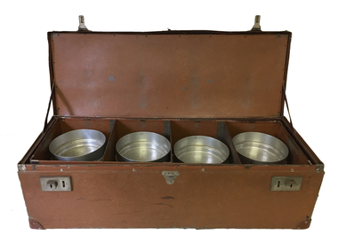 Kew Historical Society Inc
Container - Meals on Wheels delivery case
... in Cotham Road. With the building of a new Senior Citizens Centre... and originally operated out of the Council-owned South Esk in Cotham Road ...The Meals on Wheels Service in Victoria began in 1953 in South Melbourne. The service in Kew began three years after in 1956 and originally operated out of the Council-owned South Esk in Cotham Road. With the building of a new Senior Citizens Centre, the service moved to Childers Street.Leather case containing 12 aluminium containers, stacked in groups of three which was used to deliver meals to elderly residents by the Kew Meals on Wheels group. The program was initiated in 1956. The items were presented to the Society in 2008 by Dorothy Fox, President of the Kew Seniors Association.meals on wheels (kew), south esk - kew elder citizens, dorothy fox -
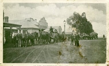 Ararat & District Historical Society (operating the Langi Morgala Museum)
Photograph, Willaura Weighbridge
... roads, some early European buildings and three supply wagons... photograph of a streetscape with wide dirt roads, some early European ...This photograph shows a point in time (late 19C) at the Willaura weighbridge which no longer exists. The weighbridge was part of a transportation system that included horses, wagons, silos, and trains and when this photograph was taken, the weighbridge was crowded with people and wagons. Black and white photograph of a streetscape with wide dirt roads, some early European buildings and three supply wagons. Two are horse drawn and the third is pulled by bullock, with six men driving the wagons and standing in the roadway. Front: "Willaura Weighbridge"willaura, weighbridge, postcard, horses, wagons, wool, transport -
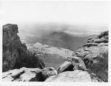 Halls Gap & Grampians Historical Society
Photograph, C 1960s
... in the middle of the photo buildings, roads and cleared land can be seen.... the valley in the middle of the photo buildings, roads and cleared ...The valley is known as Fyans Valley and the township of Halls Gap. Photo is typical of those taken by the Forestry Commission (Vic) during the 1960s.Photo shows two rocky outcrops in the foreground framing a valley in the distance below. A partial view of a mountain range flanks the valley. Plains of trees and open fields, and also a lake, can be seen beyond the mountain range. Within the valley in the middle of the photo buildings, roads and cleared land can be seen.scenery, fyans valley -
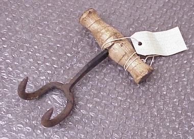 National Wool Museum
Bale Hook
... Western Beach Road between Dalgety North building and Dennys... from Western Beach Road between Dalgety North building ...Found by RC and J Lewis in laneway running south from Western Beach Road between Dalgety North building and Dennys Lachelles building (old Corio Tannery site). -
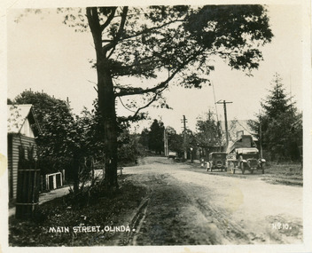 Mt Dandenong & District Historical Society Inc.
Photograph, Main Street, Olinda, c1930s
... towards Range Road. Left hand building is old Olinda Post Office... towards Range Road. Left hand building is old Olinda Post Office ...Number 10 in commercial seriesSmall photograph, number 10 in Olinda series, showing Main Street Olinda. View is looking NW from Olinda Monbulk Road towards Range Road. Left hand building is old Olinda Post Office. Ice truck is outside shops in distance and a delivery truck with tarp can be seen. c1930solinda, post office, truck -
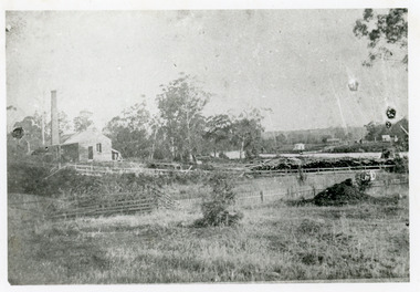 Lakes Entrance Historical Society
Photograph - Johnsonville Creamery, 1895
... , situated on the southern bank of the Tambo River on Punt Road... on the southern bank of the Tambo River on Punt Road. A small timber ...Original creamery was at Bruthen, ,shifted to Johnsonville in March 1892, run by the Chilled Butter Company until 1899 with Mr G Lucas, last manager.Black and white photograph of the Johnsonville Creamery, situated on the southern bank of the Tambo River on Punt Road. A small timber building with gable roof, large chimney adjacent, punt landing and roadway on opposite bank. Johnsonville Victoriadairying, primary industry -
Federation University Historical Collection
Document - Document - Ballarat School of Mines, Documents relating to Ballarat School of Mines: Collected by Jack Barker, 1960s to 1980s
... . Papers relate to building extensions. roads, speeches over three... to building extensions. roads, speeches over three decades. E.J ...E.J. Barker is a past principal of the School of Mines Ballarat and the Library at the Mt Helen Campus is named after him. Papers relate to building extensions. roads, speeches over three decades. Various documents, charts, correspondence collected by E.J. Barkere.j. barker, lydiards street south closure, staff structure 1970, building developments 1965, regional colleges, higher education, melbourne university, college of advanced education, affiliation, professor don aitkin address, staffing, management, ballarat teachers college, victorian institute of colleges, smb personnel, retirements, obituaries, a f heseltine report -
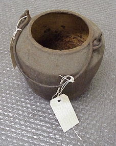 National Wool Museum
Pot, smelting
... south from Western Beach Road between Dalgety North building... running south from Western Beach Road between Dalgety North ...Found by Roger Cummings and J Lewis in laneway running south from Western Beach Road between Dalgety North building and Dennys Lachelles building (old Corio Tannery site). -
National Wool Museum
Pot, smelting
... south from Western Beach Road between Dalgety North building... running south from Western Beach Road between Dalgety North ...Found by Roger Cummings and J Lewis in laneway running south from Western Beach Road between Dalgety North building and Dennys Lachelles building (old Corio Tannery site). -
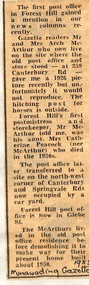 Whitehorse Historical Society Inc.
Newspaper - Article, Post Office, 1983
... to the North West corner of Canterbury Road and Springvale Road...Whitehorse Historical Society Inc. 2-10 Deep Creek Road ...Article in Nunawading Gazette about the first Post Office in Forest Hill. The first postmistress was Catherine Peacock (and storekeeper) who died in the 1930's. Later the P.O. was transferred to the North West corner of Canterbury Road and Springvale Road. The first Post Office and store was located at 259 Canterbury Road and this building was demolished in 1950.post offices, peacock, catherine, mcarthur, archibald, canterbury road, forest hill, no 259, forest hill post office -
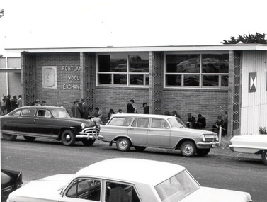 Glenelg Shire Council Cultural Collection
Photograph, Portland Wool Exchange, n.d
... are parked and are driving on road at front of building.... are parked and are driving on road at front of building. Portland ...Port of Portland AuthorityFront: (no inscriptions) Back: 177 (centre, pencil)port of portland -
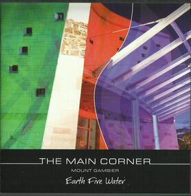 The Adam Lindsay Gordon Commemorative Committee Inc.
Booklet, The Main Corner, Mount Gambier : earth, fire, water, 2011
... located at 1 Bay Road, Mount Gambier. The building and surrounds... Road, Mount Gambier. The building and surrounds offer ...Information booklet about the new Main Corner complex located at 1 Bay Road, Mount Gambier. The building and surrounds offer the opportunity to learn about Mount Gambier's local history and culture.For two years he was stationed at Penola in the Mount Gambier region where he led a routine life with no remarkable incidents or exploits to interrupt his daily duties. (from Australian Dictionary of Biography: http://adb.anu.edu.au/biography/gordon-adam-lindsay-3635)22 pages booklet with colour illustrations. Front page depicting the entrance of the Main Corner in Mount Gambiermain corner, mount gambier, gretel sneath, adam lindsay gordon -
 Eltham District Historical Society Inc
Document - Series Listing, Fraser Faithfull et al, Series 38: Pioneers & Painters - Typescript Drafts and Documentation, 2000
... mounted photograph of the author, plus 10 B&W snapshots of roads... mounted photograph of the author, plus 10 B&W snapshots of roads ...Series consists of 2 typescript drafts of Pioneers & Painters - One Hundred Years ofEltham and Its Shire, by Alan Marshall (originally published 1971, reissued 1979) An annual list of Councillors 1912 - 1975, contained in an exercise book One notebook . Folder containing correspondence with the author and others, c. 1963 - 1970 Folder containing documents and background notes Folder containing newsclippir/s c. 1929 - 1970 Folder containing mounted photograph of the author, plus 10 B&W snapshots of roads and buildings work, c. 1962shire of eltham archives, series listing -
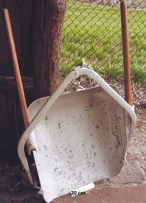 City of Moorabbin Historical Society (Operating the Box Cottage Museum)
Tool - Horse-drawn Metal Scoop Road-working
... in the late 1800s, and up until the 1940s for road-works, building... 1800s, and up until the 1940s for road-works, building dams ...This medium sized metal, horse-drawn, road-working scoop, with timber shafts is an example of those used in Moorabbin Shire in the late 1800s, and up until the 1940s for road-works, building dams, market-gardening work and other similar earthworks in the shire. The Box Cottage museum example would have been drawn by one horse, with the worker walking and steering the horse and scoop from behind using the timber shafts. There were even bigger metal scoops that required two or more horses to drag the scoop through the soil.Following the Dendy Special Survey 1841 allotments were sold to pioneer settlers who established market gardens in the Moorabbin area. Roads and roadside dams were needed as they transported both their stock and garden produce to markets in St Kilda and Melbourne By1880 the Shire of Moorabbin was using horse-drawn, road-working shovels on the main thoroughfares of the district.A medium sized metal, horse-drawn, road-working scoop, with timber shafts. Used by Moorabbin Shire in the late 1800s, and early 1900s for road-works, and other similar work in the shiremelbourne, shovel, brighton, moorabbin, metal, gardens, roads, markets, mckinnon, cheltenham, horse drawn, scoop, dendy henry, st kilda -
 Kew Historical Society Inc
Photograph - Former Kew Police Station : Parking lot, 1996
... was the junction of Bulleen and Cotham Roads. The buildings were designed... was the junction of Bulleen and Cotham Roads. The buildings were designed ...A civic campaign for new public offices developed in Kew in the 1880s. After much deliberation, the location chosen was the junction of Bulleen and Cotham Roads. The buildings were designed by George Watson and John Henry Harvey, architects within the Department of Public Works (Victoria). Building was commenced in 1887, and after one year, the buildings were opened. The Post Office was transferred to the new Commonwealth Government in 1901. The Police Station and Court House, sold by the Victorian Government to the City of Boroondara in 2007, are now a community cultural centre and performing arts venue.The buildings were listed on the Victorian Heritage Register Register (HO885) in 1991. They are historically and architecturally significant to the State of Victoria because Watson and Harvey's designs exhibit diversity in integrating civil offices, they accommodate the apex of road junctions, and they demonstrate a departure from the contemporaneously favoured High Victorian Classical to the Queen Anne style in the design of civic buildings.View through the old wire gates into the parking lot behind the former Kew Police Station and Court House. This was the entrance from Cotham Road with which supplies, prisoners, and police cars would enter.kew court house, public offices -- kew (vic), kew police station -
 Kew Historical Society Inc
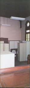
Photograph - Former Kew Court House : Court Room, 1996
... was the junction of Bulleen and Cotham Roads. The buildings were designed... was the junction of Bulleen and Cotham Roads. The buildings were designed ...A civic campaign for new public offices developed in Kew in the 1880s. After much deliberation, the location chosen was the junction of Bulleen and Cotham Roads. The buildings were designed by George Watson and John Henry Harvey, architects within the Department of Public Works (Victoria). Building was commenced in 1887, and after one year, the buildings were opened. The Post Office was transferred to the new Commonwealth Government in 1901. The Police Station and Court House, sold by the Victorian Government to the City of Boroondara in 2007, are now a community cultural centre and performing arts venue.The buildings were listed on the Victorian Heritage Register Register (HO885) in 1991. They are historically and architecturally significant to the State of Victoria because Watson and Harvey's designs exhibit diversity in integrating civil offices, they accommodate the apex of road junctions, and they demonstrate a departure from the contemporaneously favoured High Victorian Classical to the Queen Anne style in the design of civic buildings.Former court room of the Kew Court House. By 1993 when this photograph was taken, the room had been taken over by the Kew Police Station and used for police lockers and as a briefing room. In the foreground the edge of the magistrates' desk can be seen and in the distance the railing used to separate the public gallery from the main section of the court. This railing was repositioned to the foyer during the renovations of the Court House from 2007-11. The magistrates' desk was destroyed. kew court house, public offices -- kew (vic), kew police station -
 Kew Historical Society Inc
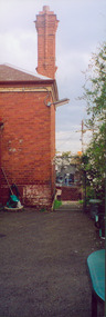
Photograph - Former Kew Police Station : Wall and chimney, 1996
... was the junction of Bulleen and Cotham Roads. The buildings were designed... was the junction of Bulleen and Cotham Roads. The buildings were designed ...A civic campaign for new public offices developed in Kew in the 1880s. After much deliberation, the location chosen was the junction of Bulleen and Cotham Roads. The buildings were designed by George Watson and John Henry Harvey, architects within the Department of Public Works (Victoria). Building was commenced in 1887, and after one year, the buildings were opened. The Post Office was transferred to the new Commonwealth Government in 1901. The Police Station and Court House, sold by the Victorian Government to the City of Boroondara in 2007, are now a community cultural centre and performing arts venue.The buildings were listed on the Victorian Heritage Register Register (HO885) in 1991. They are historically and architecturally significant to the State of Victoria because Watson and Harvey's designs exhibit diversity in integrating civil offices, they accommodate the apex of road junctions, and they demonstrate a departure from the contemporaneously favoured High Victorian Classical to the Queen Anne style in the design of civic buildings.View through the Cotham Road carpark towards High Street of the southeast corner of the former police station. The use of red brick, tall brick chimneys and slate roof were representative of the Queen Ann Style used in the construction of the Kew Public Offices in 1888.public offices -- kew (vic), kew police station