Showing 577 items matching "shire of diamond valley"
-
 Greensborough Historical Society
Map, Melbourne and Metropolitan Board of Works. Survey Division, MMBW, Yarra 2500 / 13.26. Yarrambat, Worns Lane, 1978_02
... shire of diamond valley... board of works shire of diamond valley whttlesea yarrambat ...Melbourne and Metropolitan Board of Works. Yarra 2500 [base map] 13.26. Yarrambat, Worns Lane. Municipalities of Diamond Valley 257 and Whittlesea 239. Prominent streets include: Worns Road, North Oatlands Road and Licola Street. Features include Plenty River.MMBW Map in 1:2500 [scale] series. Cream parchment with green tape reinforcing on edges and punched holes on left edge.mmbw, melbourne and metropolitan board of works, shire of diamond valley, whttlesea, yarrambat - maps -
 Greensborough Historical Society
Map, Melbourne and Metropolitan Board of Works. Survey Division, MMBW, Yarra 2500 / 13.23. Plenty, Middle Gorge, 1978_04
... shire of diamond valley.... Parish of Morang 3183. Municipalities of Diamond Valley 257 ...Melbourne and Metropolitan Board of Works. Yarra 2500 [base map] 13-23. Plenty / Middle Gorge. Parish of Morang 3183. Municipalities of Diamond Valley 257 and Whittlesea 239. Prominent streets include: Gorge Road, Kurrak Road and Browns Lane. Features include the Plenty River and Plenty Gorge Park.MMBW Map in 1:2500 [scale] series. Cream parchment with green tape reinforcing on edges and punched holes on left edge.mmbw, melbourne and metropolitan board of works, shire of diamond valley, plenty - maps, plenty gorge park -
 Greensborough Historical Society
Map, Melbourne and Metropolitan Board of Works. Survey Division, MMBW, Yarra 2500 / 14.23. Diamond Creek, Sutherland Homes, 1979_05
... shire of diamond valley... and metropolitan board of works shire of diamond valley plenty - maps ...Melbourne and Metropolitan Board of Works. Yarra 2500 [base map] 14.23. Diamond Creek, Sutherland Homes. Parish of Morang 3183 and Nillumbik 3310. Municipality of Diamond Valley 257. Prominent streets Aqueduct Road, Diamond Creek Road, Yan Yean Road and McLaughlans Lane. Features include the abandoned Maroondah aqueduct and Sutherland Cottages.MMBW Map in 1:2500 [scale] series. Cream parchment with green tape reinforcing on edges and punched holes on left edge.mmbw, melbourne and metropolitan board of works, shire of diamond valley, plenty - maps, sutherland homes, maroondah aqueduct -
 Greensborough Historical Society
Map, Melbourne and Metropolitan Board of Works. Survey Division, MMBW, Yarra 2500 / 14.22. St Helena, St Katherine's Church, 1979_08
... shire of diamond valley... and metropolitan board of works shire of diamond valley st helena - maps st ...Melbourne and Metropolitan Board of Works. Yarra 2500 [base map] 14.22. St Helena, St Katherine's Church. Parish of Nillumbik 3310. Municipality of Diamond Valley 257. Prominent streets St Helena Road, Weidlich Road, Yan Yean Road and Allumba Drive. Features include St Katherine's Church of England and the St Helena Secondary College site.MMBW Map in 1:2500 [scale] series. Cream parchment with green tape reinforcing on edges and punched holes on left edge.mmbw, melbourne and metropolitan board of works, shire of diamond valley, st helena - maps, st katherines church st helena -
 Greensborough Historical Society
Map, Melbourne and Metropolitan Board of Works. Survey Division, MMBW, Yarra 2500 / 14.21. St Helena, Weidlich Road, 1979_08
... shire of diamond valley... and metropolitan board of works shire of diamond valley st helena - maps ...Melbourne and Metropolitan Board of Works. Yarra 2500 [base map] 14.21. St Helena, Weidlich Road. Parish of Nillumbik 3310. Municipality of Diamond Valley 257. Prominent streets St Helena Road, Weidlich Road, Karingal Drive and Progress Road. Features include the Blair Reserve.MMBW Map in 1:2500 [scale] series. Cream parchment with green tape reinforcing on edges and punched holes on left edge.mmbw, melbourne and metropolitan board of works, shire of diamond valley, st helena - maps -
 Greensborough Historical Society
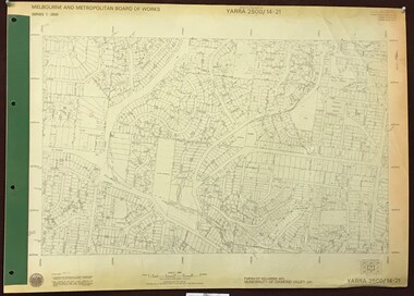
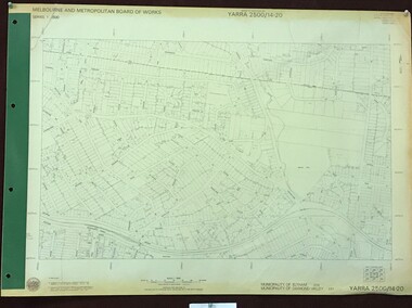
Map, Melbourne and Metropolitan Board of Works. Survey Division, MMBW, Yarra 2500 / 14.20. Montmorency, Sherbourne Road, 1977_06
... shire of diamond valley... and metropolitan board of works shire of diamond valley montmorency - maps ...Melbourne and Metropolitan Board of Works. Yarra 2500 [base map] 14.20. Montmorency, Sherbourne Road. Municipality of Diamond Valley 257 and Eltham 238. Prominent streets: Sherbourne Road, Karingal Drive and Calrossie Avenue. Features include Montmorency Station and Meruka Park.MMBW Map in 1:2500 [scale] series. Cream parchment with green tape reinforcing on edges and punched holes on left edge.mmbw, melbourne and metropolitan board of works, shire of diamond valley, montmorency - maps -
 Greensborough Historical Society
Map, Melbourne and Metropolitan Board of Works. Survey Division, MMBW, Yarra 2500 / 13.28. Mernda, Wilton Vale, 1977_08
... shire of diamond valley... and metropolitan board of works shire of diamond valley mernda - maps MMBW ...Melbourne and Metropolitan Board of Works. Yarra 2500 [base map] 13.28. Mernda, Wilton Vale. Municipality of Diamond Valley 257 and Whittlesea 239. Prominent streets: Wilton Vale Road. Features include Yan Yean Pipe Track and SEC Transmission Lines. The abandoned rail line (old Whittlesea line) is in the top left corner.MMBW Map in 1:2500 [scale] series. Cream parchment with green tape reinforcing on edges and punched holes on left edge.mmbw, melbourne and metropolitan board of works, shire of diamond valley, mernda - maps -
 Greensborough Historical Society
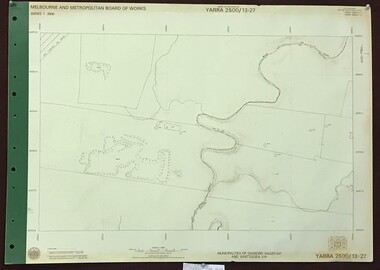
Map, Melbourne and Metropolitan Board of Works. Survey Division, MMBW, Yarra 2500 / 13.27. Morang wetlands, 1977_09
... shire of diamond valley... and metropolitan board of works shire of diamond valley morang - maps MMBW ...Melbourne and Metropolitan Board of Works. Yarra 2500 [base map] 13.27. Morang wetlands. Municipality of Diamond Valley 257 and Whittlesea 239. Features include the Plenty River and SEC Transmission Line easement. MMBW Map in 1:2500 [scale] series. Cream parchment with green tape reinforcing on edges and punched holes on left edge.mmbw, melbourne and metropolitan board of works, shire of diamond valley, morang - maps -
 Greensborough Historical Society
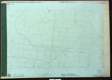
Map, Melbourne and Metropolitan Board of Works. Survey Division, MMBW, Yarra 2500 / 14.25. Plenty, Heard Road, 1978_02
... shire of diamond valley... of works shire of diamond valley plenty - maps MMBW Map in 1:2500 ...Melbourne and Metropolitan Board of Works. Yarra 2500 [base map] 14.25. Plenty, Heard Road. Parishes of Greensborough 2724, Nillumbik 3310 and Morang 3183. Municipality of Diamond Valley 257. Prominent streets include: Heard Road, Seymour Drive and Yan Yean Road.MMBW Map in 1:2500 [scale] series. Cream parchment with green tape reinforcing on edges and punched holes on left edge.mmbw, melbourne and metropolitan board of works, shire of diamond valley, plenty - maps -
 Greensborough Historical Society
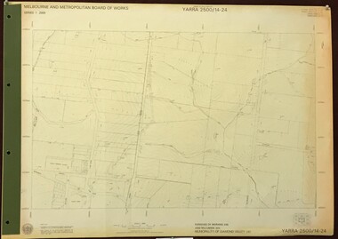
Map, Melbourne and Metropolitan Board of Works. Survey Division, MMBW, Yarra 2500 / 14.24. Plenty, 1979_05
... shire of diamond valley... of Nillumbik 3310 and Morang 3183. Municipality of Diamond Valley 257 ...Melbourne and Metropolitan Board of Works. Yarra 2500 [base map] 14.24. Plenty. Parishes of Nillumbik 3310 and Morang 3183. Municipality of Diamond Valley 257. Prominent streets include: Heard Road, Hillmartin Road and Yan Yean Road. Features include Plenty Primary School and Plenty Park.MMBW Map in 1:2500 [scale] series. Cream parchment with green tape reinforcing on edges and punched holes on left edge.mmbw, melbourne and metropolitan board of works, shire of diamond valley, plenty - maps -
 Greensborough Historical Society
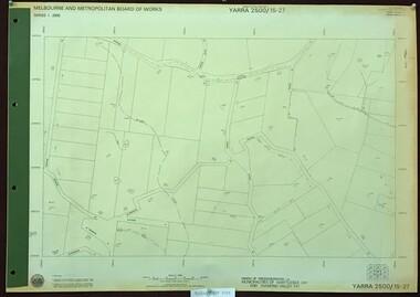
Map, Melbourne and Metropolitan Board of Works. Survey Division, MMBW, Yarra 2500 / 15.27. Yarrambat, De Fredricks Lane, 1977_10
... shire of diamond valley... melbourne and metropolitan board of works shire of diamond valley ...Melbourne and Metropolitan Board of Works. Yarra 2500 [base map] 15.27. Yarrambat, De Fredricks Lane. Parish of Greensborough 2724. Municipality of Diamond Valley 257 and Whittlesea 239. Prominent streets include: De Fredricks Lane, Astons Road and Bannons Lane. Features include Scrubby Creek.MMBW Map in 1:2500 [scale] series. Cream parchment with green tape reinforcing on edges and punched holes on left edge.mmbw, melbourne and metropolitan board of works, shire of diamond valley, yarrambat - maps -
 Greensborough Historical Society
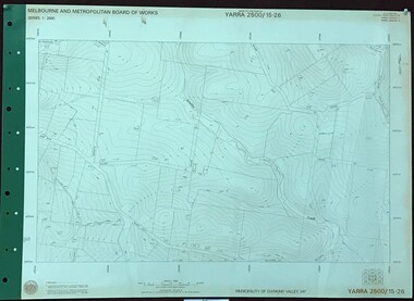
Map, Melbourne and Metropolitan Board of Works. Survey Division, MMBW, Yarra 2500 / 15.26. Yarrambat, Hacketts Road, 1978_07
... shire of diamond valley... shire of diamond valley yarrambat - maps MMBW Map in 1:2500 ...Melbourne and Metropolitan Board of Works. Yarra 2500 [base map] 15.26. Yarrambat, Hacketts Road. Municipality of Diamond Valley 257. Prominent streets include: Black Gully Road, Hacketts Road and Collins Lane. Features include Scrubby Creek.MMBW Map in 1:2500 [scale] series. Cream parchment with green tape reinforcing on edges and punched holes on left edge.mmbw, melbourne and metropolitan board of works, shire of diamond valley, yarrambat - maps -
 Greensborough Historical Society
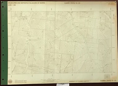
Map, Melbourne and Metropolitan Board of Works. Survey Division, MMBW, Yarra 2500 / 15.25. Yarrambat, Black Gully Road, 1978_07
... shire of diamond valley... and metropolitan board of works shire of diamond valley yarrambat - maps ...Melbourne and Metropolitan Board of Works. Yarra 2500 [base map] 15.25. Yarrambat, Black Gully Road. Municipality of Diamond Valley 257. Prominent streets include: Black Gully Road, Ironbark Road and Murray Road. MMBW Map in 1:2500 [scale] series. Cream parchment with green tape reinforcing on edges and punched holes on left edge.mmbw, melbourne and metropolitan board of works, shire of diamond valley, yarrambat - maps -
 Greensborough Historical Society
Map, Melbourne and Metropolitan Board of Works. Survey Division, MMBW, Yarra 2500 / 15.24. Diamond Creek, Grassy Flat Road, 1978_02
... shire of diamond valley... Road. Parish of Nillumbik 3310. Municipality of Diamond Valley ...Melbourne and Metropolitan Board of Works. Yarra 2500 [base map] 15.24. Diamond Creek, Grassy Flat Road. Parish of Nillumbik 3310. Municipality of Diamond Valley 257. Prominent streets include: Everleigh Drive, Broad Gully Road and Clyde Street. Features include the Diamond Creek, Nillumbik Park and Diamond Creek Reservoir.MMBW Map in 1:2500 [scale] series. Cream parchment with green tape reinforcing on edges and punched holes on left edge.mmbw, melbourne and metropolitan board of works, diamond creek - maps, shire of diamond valley -
 Greensborough Historical Society
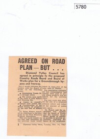
Newspaper Clipping, Diamond Valley News, Agreed on road plan ... but, 14/11/1967
... shire of diamond valley... shire of diamond valley Newspaper clipping, black and white text ...Diamond Valley Council agreed in principle to the proposed Greensborough By-pass and freeway, with further discussion needed on some points.Newspaper clipping, black and white text.greensborough bypass, shire of diamond valley -
 Greensborough Historical Society
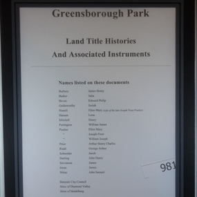
Folder of Documents, Greensborough Park: Land Title Histories and Associated Instruments, 1872-1976
... shire of diamond valley... banyule city council shire of heidelberg shire of diamond valley ...Land title documents trace the ownership of what is now known as Greensborough Park from 1872 to 1976.This property was owned at various times by well known Greensborough identities. The documents show the change from private ownership to public ownership of the site.Folder of copies of land title documents. 20 pages. Includes CD of electronic copies.greensborough park, banyule city council, shire of heidelberg, shire of diamond valley -
 Greensborough Historical Society
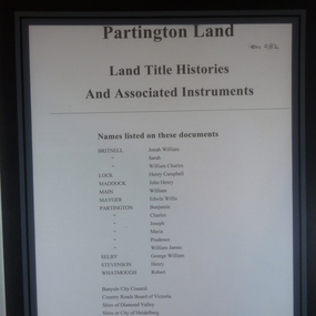
Folder of Documents, Partington land: Land Title Histories and Associated Instruments, 1826o
... shire of diamond valley... council shire of heidelberg shire of diamond valley Folder ...Land title documents trace the ownership of land owned by the Partington family of Greensborough.The Partington family are Greensborough pioneers and have lived in the area since the 1840s.Folder of copies of land title documents. 36 pages. partington, plenty river, banyule city council, shire of heidelberg, shire of diamond valley -
 Eltham District Historical Society Inc
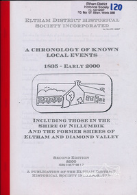
Book, Harry Gilham, A chronology of known local events 1835 - early 2000 including those in the Shire of Nillumbik and the former Shires of Eltham and Diamond Valley, 2000
... shire of diamond valley... of this local community. shire of eltham shire of diamond valley ...2nd edition. "The design of this document is to provide information to access known publications and resource collections that are publicly available for study... this collection of 974 historical events is not complete". The publication is arranged by year order with a brief statement of historical event with source abbreviation. Source list provided. Includes index. Produced by the Eltham District Historical Society Inc.This edition, one of several, is a significant reference document for the history of the Shire of Nillumbik and former Shires of Eltham and Diamond Valley bringing together a timeline of key events in the history of this local community. Softcover; 1 v. (unpaged) ; 30 cm.ISBN 0957719817shire of eltham, shire of diamond valley, chronology, eltham district historical society -
![Newspaper clipping [copy], Diamond Valley News, Councils mixed on boundary changes, 26/10/1994](/media/collectors/4f729f5697f83e03086015b8/items/55c1aeb92162f110e0f9418d/item-media/55c1aef02162f110e0f946f9/item-fit-380x285.jpg) Greensborough Historical Society
Greensborough Historical SocietyNewspaper clipping [copy], Diamond Valley News, Councils mixed on boundary changes, 26/10/1994
... shire of diamond valley...' is referred to as 'Montsalvat'. shire of diamond valley shire ...Discusses the restructure of Eltham and Diamond Valley Shires in 1994. In this article, the present 'Nillumbik' is referred to as 'Montsalvat'.Newspaper clipping, one page, black and white image and black text.shire of diamond valley, shire of eltham, banyule -
 Greensborough Historical Society
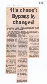
Article - Newspaper Clipping, Diamond Valley News, 'It's chaos': Bypass is changed 1985, 20/08/1985
... shire of diamond valley... greensborough road grimshaw street greensborough shire of diamond valley ...Article about plans for Greensborough bypass to be alteredNewspaper clipping with black text greensborough road, grimshaw street greensborough, shire of diamond valley, greensborough bypass -
![Article - Newspaper Clipping - Digital Image, Objections to street scheme withdrawn [Calrossie Avenue Montmorency], 05/11/1965](/media/collectors/4f729f5697f83e03086015b8/items/5eb3892321ea670b94d36b17/item-media/5eb389de21ea670b94d4605a/item-fit-380x285.jpg) Greensborough Historical Society
Greensborough Historical SocietyArticle - Newspaper Clipping - Digital Image, Objections to street scheme withdrawn [Calrossie Avenue Montmorency], 05/11/1965
... shire of diamond valley... montmorency shire of diamond valley street construction News clipping ...In 1965, tenders were called for the construction of streets in Montmorency after objections were withdrawn.An example of concerns over road construction in the formerly 'bush' areas of Diamond ValleyNews clipping, black and white textmontmorency streets, calrossie avenue montmorency, meadow crescent montmorency, lilicur road montmorency, woodland grove montmorency, st faiths road montmorency, glenauburn estate montmorency, shire of diamond valley, street construction -
 Eltham District Historical Society Inc
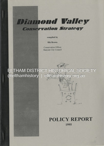
Book, Richard E. G. Brown, Diamond Valley Conservation Strategy: Policy Report, 1995
... Shire of Diamond Valley... protection Shire of Diamond Valley The Diamond Valley Conservation ...The Diamond Valley Conservation Strategy will be used by Nillumbik and Banyule councils when developing conservation policies. The strategy was developed by the former Shire of Diamond Valley and documents environment and heritage values and possible threats to those values of the former Shire and policy aims and objectives. This report documents flora and fauna conservation, heritage conservation, landscape conservation, sustainable land use, conservation of resources, waster management and community education and involvement. The Shire of Diamond Valley (1964-1994) was abolished in May 1994. Areas merged with the newly created Shire of Nillumbik, City of Banyule and City of Whittlesea.27 p.non-fictionThe Diamond Valley Conservation Strategy will be used by Nillumbik and Banyule councils when developing conservation policies. The strategy was developed by the former Shire of Diamond Valley and documents environment and heritage values and possible threats to those values of the former Shire and policy aims and objectives. This report documents flora and fauna conservation, heritage conservation, landscape conservation, sustainable land use, conservation of resources, waster management and community education and involvement. The Shire of Diamond Valley (1964-1994) was abolished in May 1994. Areas merged with the newly created Shire of Nillumbik, City of Banyule and City of Whittlesea.environmental policy, environmental protection, shire of diamond valley -
 Eltham District Historical Society Inc
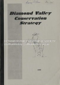
Book, Richard E. G. Brown, Diamond Valley Conservation Strategy, 1995
... Shire of Diamond Valley...Shire of Diamond Valley conservation environmental policy ...The Diamond Valley Conservation Strategy, compiled by Rik Brown, Conservation Officer, Banyule City Council will be used by Nillumbik and Banyule councils when developing conservation policies. The strategy was developed by the former Shire of Diamond Valley and documents environment and heritage values and possible threats to those values of the former Shire and policy aims and objectives. The Shire of Diamond Valley (1964-1994) was abolished in May 1994. Areas merged with the newly created Shire of Nillumbik, City of Banyule and City of Whittlesea.non-fictionThe Diamond Valley Conservation Strategy, compiled by Rik Brown, Conservation Officer, Banyule City Council will be used by Nillumbik and Banyule councils when developing conservation policies. The strategy was developed by the former Shire of Diamond Valley and documents environment and heritage values and possible threats to those values of the former Shire and policy aims and objectives. The Shire of Diamond Valley (1964-1994) was abolished in May 1994. Areas merged with the newly created Shire of Nillumbik, City of Banyule and City of Whittlesea.shire of diamond valley, conservation, environmental policy, strategy -
 Greensborough Historical Society
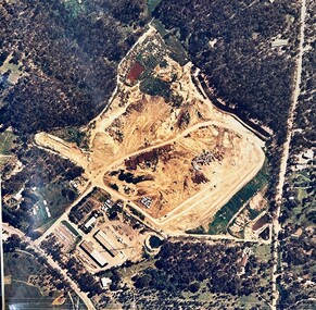
Map - Aerial Photograph, Yarrambat, 04/11/1986
... shire of diamond valley...Colour aerial photograph of Diamond Valley Shire Depot...Colour aerial photograph of Diamond Valley Shire Depot ...Colour aerial photograph of Diamond Valley Shire Depot, Yarrambat, now Nillumbik Shire Council Works Depot & Recycling CentreColour aerial photograph. Scale approx. 1:1000shire of diamond valley, yarrambat, nillumbik council -
 Melbourne Tram Museum
Legal record, Victorian Government, "Act of Parliament", 1/12/1978 12:00:00 AM
... and the Shire of Diamond Valley and the Shire of Whittlesea in Plenty... in the City of Preston and the Shire of Diamond Valley and the Shire ...Act of the Victorian Parliament to authorize the construction by the MMTB of an electric tramway in the City of Preston and the Shire of Diamond Valley and the Shire of Whittlesea in Plenty Road, to Settlement Road. Dated 5/12/1978trams, tramways, mmtb, acts of parliament, new tramway, east preston, plenty rd, construction -
 Greensborough Historical Society
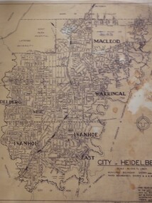
Map, City of Heidelberg: Municipal and Ward boundaries, 1967c
... to the separation of Heidelberg's North Ward to become the Shire of Diamond... to become the Shire of Diamond Valley city of heidelberg heidelberg ...This map of the City of Heidelberg was issued subsequent to the separation of Heidelberg's North Ward to become the Shire of Diamond ValleyBlack on waxed paper. Scale: 20 chs to 1 inchG M Hutchins. 50c.city of heidelberg, heidelberg -
 Eltham District Historical Society Inc
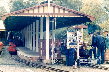
Photograph, Diamond Valley Railway, Eltham Lower Park, 1985, 1985
... series 13 shire of eltham archives diamond valley railway Five ...Shire of Eltham Archives Series 13, Photograph Album, 1985. Originally contained in a 2-ring PVC binder and document sleevesFive colour photographsseries 13, shire of eltham archives, diamond valley railway -
 Greensborough Historical Society
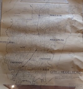
Map, City of Heidelberg. Engineers Dept, City of Heidelberg, 1960s
... in the South to North of Watsonia Military Camp. Shire of Diamond.... Shire of Diamond Valley is shown to the north. city ...Map of the City of Heidelberg from the Yarra River in the South to North of Watsonia Military Camp. Shire of Diamond Valley is shown to the north.Map showing municipal and ward boundaries, black text on light brown paper."Scale: 20 CHS = to 1 IN"city of heidelberg -
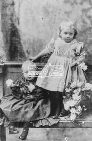 Eltham District Historical Society Inc
Photograph, Edith (seated) and Mabel Milthorpe, daughters of Mr and Mrs C. Milthorpe of Diamond Creek
... of The Diamond Valley Story by Dianne H. Edwards, Shire of Diamond Valley... of The Diamond Valley Story by Dianne H. Edwards, Shire of Diamond Valley ...Photo sourced from E. Whicker reproduced on p51 of The Diamond Valley Story by Dianne H. Edwards, Shire of Diamond Valley 1979.Black and white copy of photo printed on glossy photographic paper 30.5 x 40.5 cm (12 x 16 inch); image size approx. 18.5 x 28 cmc. milthorpe, diamond creek, diamond valley story, edith milthorpe, groups, mabel milthorpe -
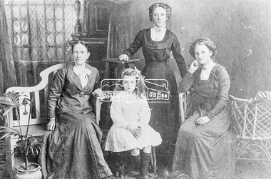 Eltham District Historical Society Inc
Photograph, L-R: Mrs Delaney and her daughter, Mrs Middleton and Mrs W. Heddle of Diamond Creek
... of The Diamond Valley Story by Dianne H. Edwards, Shire of Diamond Valley... of The Diamond Valley Story by Dianne H. Edwards, Shire of Diamond Valley ...Photo sourced from B. Heddle reproduced (cropped) on p49 of The Diamond Valley Story by Dianne H. Edwards, Shire of Diamond Valley 1979.Black and white copy of photo printed on glossy photographic paper 30.5 x 40.5 cm (12 x 16 inch); image size approx. 18.5 x 28 cmdiamond creek, diamond valley story, groups, mrs delaney, mrs middleton, mrs w. heddle