Showing 241 items
matching site survey
-
 Wodonga & District Historical Society Inc
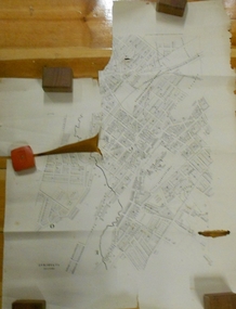
Map - Boorgunyah - "The Town that never was"
At the height of the river trade, there was a town surveyed and laid out, and streets were named. This town was to house the workers at the river port of Red Bank when the paddle steamers plied the Murray River as far as Albury, carrying produce such as wool and wheat to the various towns along the river in the 1800s. As the river trade died away, this town never went ahead – one might say, “The town that never was.” A lone gum tree stands on the site today.This item is significant because it documents plans which were made for the early development of Wodonga.A black an white map depicting the proposed location of the township. The map is based on a sketch and is not to scale,early wodonga, boorgunyah - "the town that never was", wodonga heritage -
 Department of Energy, Environment and Climate Action
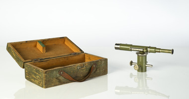
Dumpy level
Engineers level used to lay out construction sites, roads and contoursMetal dumpy with box level SCAforests commission victoria (fcv), surveying, mapping -
 Lakes Entrance Historical Society
Photograph - Lakes Entrance Grid location, 1999
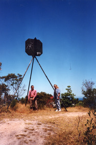
Lakes Entrance Grid reference, Cunninghame 8522.3.4 896.082, on ten acre site with trig point, it is from this point that all the survey for the surrounding areas was undertaken. Part of the Vic Geodetic Survey initiated in 1860 by Ellery Survey started from triangulation base in Werribee. (Grid ref B'dale 8422)Colour photograph of the Victoria Geodetic Survey Triangulation Station, Trig Station, situated off Ocean View Parade, Merrangbaur Hill. Location is indicated by ground point and standing structure, situated on an elevated bush block. Lakes Entrance Victoriasurveying, township planning -
 Lakes Entrance Historical Society
Book, Leith, Adrienne, East Gippsland Shire Heritage Survey Information, 1996
List of significant heritage sites in East Gippsland Shire as at 11/7/1996. Bibliography for heritage study in East Gippsland Shire.heritage, bibliography -
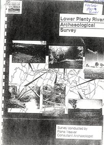
![Book - Article, Fiona Weaver, Lower Plenty River Archaeological Survey by Fiona Weaver [excerpt], 1991](/media/collectors/62fc2e8d3b4c83fe7f279a1c/items/6450d73a49371722cf4f2ee8/item-media/6450d9b949371722cf4f5830/item-fit-380x285.jpg) Heidelberg Golf Club
Heidelberg Golf ClubBook - Article, Fiona Weaver, Lower Plenty River Archaeological Survey by Fiona Weaver [excerpt], 1991
... River area. A survey of First Nations sites in the Lower Plenty ...Excerpt from Lower Plenty River Archaeological Survey by Fiona Weaver. Section 5 on Aboriginal archaeological sites in the Lower Plenty River area.A survey of First Nations sites in the Lower Plenty River area.Copy of part of book.lower plenty river, aboriginal sites -
 Greensborough Historical Society
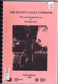
Book, Victoria Archaeological Survey, The Plenty Valley Corridor: the archaeological survey of Aboriginal sites / by Isabel Ellender 1989, 1989_
... Corridor: the archaeological survey of Aboriginal sites / by Isabel ...This archaeological survey of th Plenty Valley was conducted by Isabel Ellender in 1989 for the Ministry of Planning and Environment. The area studied is north of Greensborough to Whittlesea. A number of Aboriginal sites were identified and recommendations made for the future.103 p., illus., maps. Plastic spiral binding.plenty river, aboriginal heritage sites -
 Bendigo Military Museum
Photograph - 4th Field Survey Squadron – Operation NERVOSE Driver Training and Pre-Pack, Keswick Barracks, Adelaide SA, 1985
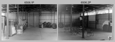
This is a set of 28 photographs taken in 1985* during 4th Field Survey Squadron’s driver training preparation and packing at Keswick Barracks, Adelaide SA, in preparation for Operation NERVOSE. Operation NERVOSE 85 was mounted by 4 Fd Svy Sqn in the EAST ARNHEM, VICTORIA RIVER DOWNS AND DALY WATERS areas of the Northern Territory from 26 May to 18 Sep 85. The aim of Operation NERVOSE 85 was to finalise the horizontal and vertical control for mapping at a scale of 1:50,000, to field check 40x 1:50,000 preliminary maps and to obtain mapping photography in support of the RAAF TINDAL redevelopment project. *Note –These photos were most likely taken in 1985, contrary to the ‘1987’ date annotated on the negative sleeves. The Op NERVOSE 85 Project Report available on RASVY’s web site lists a nominal roll of personnel. Photos of 4 Fd Svy Sqn taken in 1985 and 1987 provide names of posted personnel. Several personnel identified in these photos were posted to 4 Fd Svy Sqn in 1985, not in 1987. See items 6504.13P, 6506.16P and 6507.20P for more photos taken prior to and during Operation NERVOSE 85. This is a set of 28 photographs taken in 1985 during 4th Field Survey Squadron’s driver training preparation and packing at Keswick Barracks, Adelaide SA, in preparation for Operation NERVOSE. The colour photographs are on 35mm negative film and are part of the Army Survey Regiment’s Collection. The photographs were scanned at 96 dpi. .1) to .9) - Photo, colour, 1985. Driver training. Unidentified personnel. .10) - Photo, colour, 1985. Driver training. Bent trailer hitch shaft. .11) - Photo, colour, 1985. Theodolite set-up. L to R: CPL Kevin Whitty, CPL Alan ‘Hawkeye’ Hawkins. .12) to .14) - Photo, colour, 1985. Theodolite practice. L to R: CPL Alan ‘Hawkeye’ Hawkins, CPL Kevin Whitty. .15) - Photo, colour, 1985. Pre-packing and preparation. .16) - Photo, colour, 1985. Pre-packing and preparation. L to R: SGT Roger Rees, CPL P. Kennedy, unidentified. .17) - Photo, colour, 1985. Pre-packing and preparation. L to R: unidentified (x6), CPL Pat Drury. .18) - Photo, colour, 1985. Pre-packing and preparation. CPL Bill Choy. .19) - Photo, colour, 1985. Pre-packing and preparation. Unidentified personnel. .20) - Photo, colour, 1985. Pre-packing and preparation. L to R: LCPL Chris ‘Charlie’ Brown, WO2 Stevo Hinic, CPL Andy Lucas, SSGT George Timmins, unidentified (x3). .21) - Photo, colour, 1985. Pre-packing and preparation. L to R: MAJ Peter Bion – OC, unidentified officer, CPL Andy Lucas, SSGT George Timmins, WO2 Stevo Hinic, unidentified. .22) - Photo, colour, 1985. Pre-packing and preparation. L to R: MAJ Peter Bion – OC, unidentified officer, unidentified, SSGT George Timmins, WO2 Stevo Hinic, unidentified. .23) - Photo, colour, 1985. Pre-packing and preparation. L to R: unidentified, CPL Andy Lucas, MAJ Peter Bion – OC, unidentified officer, SSGT George Timmins, WO2 Stevo Hinic. .24) - Photo, colour, 1985. Pre-packing and preparation. L to R: SSGT George Timmins, CPL Bill Choy. .23) - Photo, colour, 1985. Pre-packing and preparation. L to R: Stevo Hinic, CPL Andy Lucas. .26) - Photo, colour, 1985. Pre-packing and preparation. L to R: CPL Kevin Whitty, SPR Dave Lambdon-Young. .27) & .28) - Photo, colour, 1985. Pre-packing and preparation. L to R: CPL Andy Lucas, Stevo Hinic..1P to .28P – There are no personnel identified. ‘1987 OP NERVOSE PRE-PACK.’ annotated on negative sleeve.royal australian survey corps, rasvy, 4 fd svy sqn, op nervose 85 -
 Bendigo Military Museum
Photograph - 4th Field Survey Squadron – Operation NERVOSE 85 Field Phase, Northern Territory, 1985
This is a set of 16 photographs taken in 1985* during 4th Field Survey Squadron’s deployment on Operation NERVOSE 85 in the Northern Territory. Operation NERVOSE 85 was mounted by 4 Fd Svy Sqn in the EAST ARNHEM, VICTORIA RIVER DOWNS AND DALY WATERS areas from 26 May to 18 Sep 85. The aim of Operation NERVOSE 85 was to finalise the horizontal and vertical control for mapping at a scale of 1:50,000, to field check 40x 1:50,000 preliminary maps and to obtain mapping photography in support of the RAAF TINDAL redevelopment project. *Note –These photos were most likely taken in 1985, contrary to the ‘1987’ date annotated on the negative sleeves. The Op NERVOSE 85 Project Report available on RASVY’s web site lists a nominal roll of personnel. Photos of 4 Fd Svy Sqn taken in 1985 and 1987 provide names of posted personnel. Several personnel identified in these photos were posted to 4 Fd Svy Sqn in 1985, not in 1987. See items 6504.13P, 6505.28P and 6507.20P for more photos taken prior to and during Operation NERVOSE 1985. This is a set of 16 photographs taken in 1985 during 4th Field Survey Squadron’s deployment on Operation Nervose in the Northern Territory. The black & white photographs are on 35mm negative film and are part of the Army Survey Regiment’s Collection. The photographs were scanned at 96 dpi. ..1) & .2) - Photo, black & white, 1985. Q-store and OPS Room. .3) & .4) - Photo, black & white, 1985. Base Camp at unknown location. .5) - Photo, black & white, 1985. Personnel spectate during a social cricket match. L to R on left: CPL Andy Lucas, unidentified (x3). L to R on right: unidentified (x4), LTCOL Kevin Murphy – SO1 Svy HQ FF Comd, unidentified, SSGT Barry Lutwyche OAM (closest to camera). .6) - Photo, black & white, 1985. Personnel spectate during a social cricket match. L to R on left: unidentified (x2). L to R on right: unidentified (x3), LCPL Chris ‘Charlie’ Brown (standing up), SSGT Barry Lutwyche OAM (closest to camera), LTCOL Kevin Murphy – SO1 Svy HQ FF Comd. .7) - Photo, black & white, 1985. CPL Andy Lucas plans an exit strategy from the latrine. .8) to .10) - Photo, black & white, 1985. Social cricket match action. .11) to .14) - Photo, black & white, 1985. LCPL Chris ‘Charlie’ Brown operates a second-generation Transit Doppler satellite Magnavox MX-1502 Satellite Surveyor Geoceiver. .15) to .16) - Photo, black & white, 1985. LCPL Steve McGuiness sets up a Geoceiver antenna..1P to .16P – There are no personnel identified. ‘1987 OP NERVOSE VICTORIA RIVER DOWNS AND DALY WATERS.’ annotated on negative sleeve.royal australian survey corps, rasvy, 4 fd svy sqn, op nervose 85 -
 Bendigo Military Museum
Photograph - 4th Field Survey Squadron – Operation NERVOSE 85 Field Phase Oblique Photos, NT, 1985
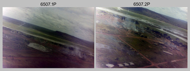
This is a set of 20 oblique aerial photographs taken during the field phase of 4th Field Survey Squadron’s Operation NERVOSE 85 project in the Northern Territory in 1985. Operation NERVOSE 85 was mounted by 4 Fd Svy Sqn in the EAST ARNHEM, VICTORIA RIVER DOWNS AND DALY WATERS areas of the Northern Territory from 26 May to 18 Sep 85. The aim of Operation NERVOSE 85 was to finalise the horizontal and vertical control for mapping at a scale of 1:50,000, to field check 40x 1:50,000 preliminary maps and to obtain mapping photography in support of the RAAF TINDAL redevelopment project. *Note –These photos were most likely taken in 1985, contrary to the ‘1987’ date annotated on the negative sleeves. The Op NERVOSE 85 Project Report available on RASVY’s web site lists a nominal roll of personnel. Photos of 4 Fd Svy Sqn taken in 1985 and 1987 provide names of posted personnel. Several personnel identified in these photos were posted to 4 Fd Svy Sqn in 1985, not in 1987. See items 6504.13P, 6505.28P and 6506.16P for more photos taken prior to and during Operation NERVOSE 1985. This is a set of 20 oblique aerial photographs taken during the field phase of 4th Field Survey Squadron’s Operation NERVOSE 85 project in the Northern Territory in 1985. The colour photographs on 35mm negative film and are part of the Army Survey Regiment’s Collection. The photographs were scanned at 96 dpi. .1) to .20) - Photo, colour, 1985. Unknown locations..1P to .20P – There are no personnel identified. ‘1987 OP NERVOSE VICTORIA RIVER DOWNS AND DALY WATERS.’ annotated on negative sleeve.royal australian survey corps, rasvy, 4 fd svy sqn, op nervose 85 -
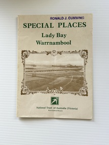 Warrnambool and District Historical Society Inc.
Pamphlet - Special Places Lady Bay Warrnambool, Philprint Warrnambool, 1989
This pamphlet was produced for the Warrnambool Branch of the National Trust of Australia (Victoria) for Heritage Week, April 16-23, 1989 and contains information written by Warrnambool residents about their locality. This was a co-operative venture by people with a common interest in protecting the natural environment near their home. Areas covered in the written information include: Formation of the Coast, Archaeological survey, Gunditjmara History, vegetation, history and recreational uses of the Lady Bay area. The map shows special places of interest including past and present navigational aids, sites of shipwrecks and other historical places of interest. The Warrnambool Branch of the National Trust was originally formed in March 1969 and merged with the Port Fairy Branch in late 1970. In October 1979, the Warrnambool Branch was reformed and operated into the late 1990's. This is an example of a publication produced by the Warrnambool Branch of the National Trust Australia (Victoria). It provides historical information and perspectives of the recreational uses in and around Lady Bay Warrnambool.An A2 piece of buff coloured thick paper folded into eight to make an A5 pamphlet. The front cover has green printing with the National Trust symbol of three eucalyptus leaves in green. There is a brown sepia photograph showing a view across Lady Bay with the suspension bridge across the Merri River in the foreground, Viaduct Road in the middle ground and the breakwater in the background. There is a purple inked stamp on the top right hand corner. The rear cover has brown writing and includes logos of bodies who assisted with the publication. There is a brown line drawing of the viaduct and pier at the Warrnambool Breakwater. The inside of the unfolded pamphlet contains a map of Lady Bay and adjacent area showing places of interest and shipwrecks marked in red circlesFront cover: Special Places Lady Bay Warrnambool National Trust of Australia (Victoria) Warrnambool Branch Ronald J. Cummingwarrnambool, lady bay warrnambool, national trust australia victoria warrnambool branch, heritage week 1989, lady bay shipwrecks -
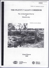 Greensborough Historical Society
Book, The Plenty Valley Corridor: the archaelogical survey of historic sites, by Fiona Weaver, for the Ministry of Planning & Environment, 1989_
... survey of historic sites, by Fiona Weaver, for the Ministry ...The Victorian Archaelogical Survey managed this study onbehalf of the Ministry for Planning & Environment. The study was intended to provide a brief history of Aboriginal and European occupation and use of the area and an outline of the geography of the chief areas of cultural heritage concern, with recommendations for protection of significant cultural sites and recommendations for further research, survey and consultation.115 p., photocopy, unbound. Illus., mapsplenty river, fiona weaver, victorian archaeological survey -
 Greensborough Historical Society
Newspaper - Newspaper Clipping - Digital Image, Diamond Valley News, Archaeological sites in corridor to be surveyed, 1990c
An undated newspaper article announcing an archaeological survey of the Plenty Valley corridor to be undertaken by Isabel Ellender and Fiona Weaver. The findings were published separately by Ellender and Weaver.Digital copy of newspaper articleplenty valley, plenty river, victoria archaeology, victorian archaeological survey, isabel ellender, fiona weaver -
 Greensborough Historical Society
Report, Lower Plenty River Archaeological Survey; Fiona Weaver, 1989_
Archaeological survey of the Lower Plenty River undertaken in 1989-1990 by Fiona Weaver for the Board of Works. Indigenous heritage sites along the Plenty River are examined and recommendations made for the preservation and to lessen the impact of development on these sites.Printed on white A4 paper. Approx 92 pages (not numbered). Illus., maps. 2 copies.plenty river, board of works, aboriginal heritage sites, fiona weaver -
 Bendigo Military Museum
Photograph - Army Survey Regiment Personnel – Mahogany Ship Survey, Warrnambool, VIC, 1985
This is a photograph of Army Survey Regiment personnel undertaking surveying measurements during a search for the ‘Mahogany Ship’ Warrnambool, VIC on 3rd September1985. CPL Mark Lander and SGT Don Williams were taking electronic distance measurements using an MRA-301 tellurometer. To measure the distance, personnel at another site operating another MRA-301 tellurometer would have exchanged the signal emission. A ‘Hilga Watts’ light appears in the background and a barometer in the foreground.This is a photograph of Army Survey Regiment personnel undertaking surveying measurements during a search for the ‘Mahogany Ship’ Warrnambool, VIC on 3rd September1985. The photograph was printed on photographic paper and is part of the Army Survey Regiment’s Collection. The photograph was scanned at 300 dpi. L to R: CPL Mark Lander, SGT Don Williams‘R.S. 3/9/1985 CPL Mark Lander, SGT Don Williams PIC BY COURTESY OF THE WARRNAMBOOL STANDARD’ annotated on back of photoroyal australian survey corps, rasvy, army survey regiment, army svy regt, fortuna, asr, surveying -
 Bendigo Military Museum
Photograph - Military Funeral for SSGT Peter Dew, Army Survey Regiment, Fortuna, Bendigo, 1977
This is a set of 29 black & white photographs of troops from the Army Headquarters Survey Regiment undertaking ceremonial drill at the military funeral for SSGT Peter Dew on the 28th of September 1977. The location of the funeral service was at Fortuna, Bendigo. He was buried at Bendigo Cemetery in Quarry Hill. Peter Dew died in a tragic accident at home. He was fondly remembered as one of Lithographic Squadron’s colourful personalities. See item 6243.7P for photos of Peter Dew at work in Lithographic Squadron. The "Super Animal of the Year" Peter Dew Memorial Award was an award presented to a member of the squadron for a crude act. To view a photo of this award, refer to item 6230 of the Victorian Collections. Some photos in this set were also printed on photo paper and catalogued under item 6335.5P.This is a set of 29 black & white photographs of troops from the Army Headquarters Survey Regiment undertaking ceremonial drill at the military funeral for SSGT Peter held in 1977. The photographs are on 35mm negative film and scanned at 96 dpi. They are part of the Army Survey Regiment’s Collection. .1) - Photo, black & white, 1977. Rifle party commander: CPL Greg Kidman. Right file right marker: SPR Russ Mollenhauer, unidentified soldiers and civilians. .2) - Photo, black & white, 1977. Unidentified soldiers and civilians. .3) - Photo, black & white, 1977. R to L: SSGT Alan Adsett, WO2 John McCulloch, SGT Graeme Jeffers in foreground holding hats. Remainder unidentified. .4) to .6) - Photo, black & white, 1977. Unidentified soldiers and civilians. R to L: SSGT Alan Adsett, WO2 John McCulloch, unidentified soldiers and civilians. .7) - Photo, black & white, 1977. Pall bearers position the coffin onto the gun carriage. Rifle party commander: CPL Greg Kidman. Right file right marker: SPR Russ Mollenhauer. Seen in background to the right of pall bearers: L to R: CPL Ian Belmont, unidentified, facing away- PTE Le-anne (Smallshaw) Shirley, CPL Di Chalmers, unidentified soldiers and civilians. .8) - Photo, black & white, 1977. Rifle party rear rank right marker: Russ Mollenhauer. Front rank rifle party commander next to right marker: Greg Kidman. Pall bearers in front of vehicle L to R: Dave Miles, Dick Barwald. Remainder unidentified. .9) - Photo, black & white, 1977. In position at beginning of funeral procession, unidentified soldiers and civilians. .10) & .11) - Photo, black & white, 1977. Rifle party commander: CPL Greg Kidman and the rifle party slow march past the front of Fortuna Villa. .12) - Photo, black & white, 1977. The rifle party slow march past the front of Fortuna Villa. Rifle party commander: Greg Kidman. Right file front to back: SPR Russ Mollenhauer, SPR Peter Breukel, SPR Bill Jones, SPR John Anderson. Remainder unidentified. Left file front to back: SPR Jeff Willey, unidentified, SPR Rhys De Laine, SPR Frank Lenane, SPR Josh Degroot, SPR Gary Drummond. .13) - Photo, black & white, 1977. The rifle party slow march past the front of Fortuna Villa. Rifle party commander: Greg Kidman. Right file: SPR Russ Mollenhauer, Left file: SPR Jeff Willey, remainder unidentified. .14) - Photo, black & white, 1977. The rifle party march at quick time towards the entry gate. .15) - Photo, black & white, 1977. The rifle party march at quick time past the front of Fortuna Villa. Rifle party commander: Greg Kidman. Right file: SPR Russ Mollenhauer, Left file: SPR Jeff Willey, remainder unidentified. .16) - Photo, black & white, 1977. The procession marches at quick time towards the entry gate. .17) - Photo, black & white, 1977. The procession departs the entry gate. .18) to .21)- Photo, black & white, 1977. The procession passes through the cemetery. .22) - Photo, black & white, 1977. The procession passes through the cemetery. RSM Wo1 Aub Harvey at far left. Remainder unidentified. .23) - Photo, black & white, 1977. Pallbearers carry Peter Dew’s coffin to the grave site. .24) - Photo, black & white, 1977. The rifle party in position at ‘rest on arms reverse’. .25) - Photo, black & white, 1977. Service at grave site. Left of minister: SGT Alan Toogood. On right of tree L to R: WO2 Max Neil, WO2 Bob Hayden, WO1 Dave Malligan, PTE Le-Anne (Smallshaw) Shirley, CAPT Stan Vote. Remainder unidentified. .26) - Photo, black & white, 1977. The rifle party fire volleys. .27) - Photo, black & white, 1977. The rifle party presents arms. .28) - Photo, black & white, 1977. Service at grave site. SGT Greg Francis-Wright 4th from right. .29) - Photo, black & white, 1977. Outside Litho’s proofing hut at Fortuna. WO1 Darby Munro stands in contemplation next to the collection of flowers.There are no personnel identified. royal australian survey corps, rasvy, army survey regiment, army svy regt, fortuna, asr, litho sqn -
 Emerald Museum & Nobelius Heritage Park
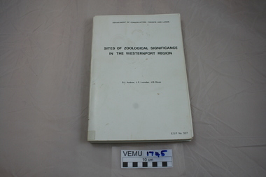
Book, Sites of Zoological Significance in the Westernport Region, 1984
Zoological Significance. The report contains the results of a survey of the vertebrate fauna of the Westernport catchment and a search of relevant literature, conducted between June 1979 and December 1981.White soft cover thick book, about A4 size. Prepared by the national Museum of Victoria for The Environmental Studies Division, Ministry of Conservation, Victoria 1984. -
University of Melbourne, Burnley Campus Archives
Plan, VCAH Burnley College, Swan Street Richmond - Site Plan 1:1000 Fire Services Survey, 1991
Plan with Buildings named, External Hydrant Sources and Main Entry Points marked. Scale 1:1000. Dated January 1991.vcah, burnley, fire safety -
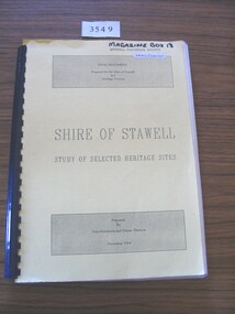 Stawell Historical Society Inc
Book, Tom Hutchison & Denise Thorson, Shire of Stawell - Study of Selected Heritage Sites, 1994
This report is a re-evaluation of the Historical Survey: Shire of Stawell as undertaken by the Stawell and Halls Gap Historical Societies in June 1990.Yellow Card cover with black print and black plastic bindingFinal Document Prepared for the Shire of Stawell and Heritage Victoria Shire of Stawell Study of Selected Heritage Sites Prepared by Tom Hutchison and Denise Thornson November 1994stawell heritage -
 Bendigo Military Museum
Photograph - 4th Field Survey Squadron – Operation NERVOSE 85 Reconnaissance, Northern Territory, 1985
This is a set of 13 photographs taken in 1985* during reconnaissance of locations in regions of the Northern Territory. Later that year, Operation NERVOSE 85 was mounted by 4 Fd Svy Sqn in the EAST ARNHEM, VICTORIA RIVER DOWNS AND DALY WATERS areas of the Northern Territory from 26 May to 18 Sep 85. The aim of Operation NERVOSE 85 was to finalise the horizontal and vertical control for mapping at a scale of 1:50,000, to field check 40x 1:50,000 preliminary maps and to obtain mapping photography in support of the RAAF TINDAL redevelopment project. *Note –These photos were most likely taken in 1985, contrary to the ‘1987’ date annotated on the negative sleeves. The Op NERVOSE 85 Project Report available on RASVY’s web site lists a nominal roll of personnel. Photos of 4 Fd Svy Sqn taken in 1985 and 1987 provide names of posted personnel. Several personnel identified in these photos were posted to 4 Fd Svy Sqn in 1985, not in 1987.This is a set of 13 photographs taken during 4th Field Survey Squadron’s reconnaissance of Operation NERVOSE 85 locations in the Northern Territory in 1985. The colour photographs are on 35mm negative film and are part of the Army Survey Regiment’s Collection. The photographs were scanned at 96 dpi. .1) to .4) - Photo, colour, 1985. Unknown location in the Northern Territory. .5) - Photo, colour, 1985. Unidentified personnel in the back of a police vehicle. .6P to .12) - Photo, colour, 1985. Unknown location in the Northern Territory. .13) - Photo, colour, 1985. L to R: Possibly MAJ A. Vickers RE - UK Exchange Officer from Army Svy Regt, unidentified officer. .1P to .13P – There are no personnel identified. ‘1987 OP NERVOSE – RECON PHOTOG.’ annotated on negative sleeve.royal australian survey corps, rasvy, 4 fd svy sqn, op nervose 85 -
 Ballarat Tramway Museum
Photograph - Colour Photograph/s, Carolyn Dean, Mar. 1999
Set of 23 photographs taken by Carolyn Dean between 6/3/1999 and 16/4/1999 of the Begonia Festival operations and moving the ex SEC bike shed to Bungaree. On Kodak paper. 1094.1 - Group of tramway staff at Gardens Loop - used in May 1999 Fares Please! .2 - tram 40 at loop .3 - sign boards used in 1999 Begonia festival .4 - Welding joint 2-3 road - Warren Doubleday and Gary Wood .5 - ditto with Alastair Reither .6 - Fixing fence at Bungaree - John Phillips .7 - ditto .8 - ditto .9 - site for the hut to go at Bungaree .10 - ditto .11 - treated pine posts for stumps .12 - checking the layout - John Phillips .13 - cutting fire wood .14 - trimming trees .15 - Dismantling the roof on the shed at Ballarat East - John Phillips and Simon Jenkins .16 - roof off .17 - ditto .18 - the moving team - used in May 1999 Fares Please - see caption for people .19 - Lifting the shed out of position .20 - ditto .21 - ditto .22 - surveying the foundations - Peter Winspur, John Phillips and Alastair Reither .23 - ditto .1 > .3 - 6/3/1999: .4 & .5 - 7/3/1999: .6 > .13 - 20/3/1999: .14 - 21/3/1999: .15> .23 - 16/4/1999 See also Reg. No. 1095 and 1101 for next stage of the move. On rear of each photo in blue ink is date in the upper edge and on lower edge "Photo by Carolyn Dean"btm, sec bike shed, begonia festival, track repairs, tram 40 -
 Melbourne Tram Museum
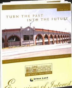
Document - Folder with papers, Urban Land corporation, "Hawthorn Tram Depot - Expressions of Interest Documentation", late 1998
White two spring clip folder with papers, titled "Hawthorn Tram Depot - Expressions of Interest Documentation", sub-titled "Turn the Past into the Future" Has a photo of Hawthorn Tram depot and an image on the front cover. Closing date 17/2/1999, prepared by the Urban Land Corporation with the assistance of VicTrack. Approx 110 pages with supplementary papers in the end covers. Contains a table of contents, checklist, EOI Process, Development Brief, Site conditions. Gives details of the heritage registration, site plans, building plans, property title and detailed room condition and use of the ground floor. Supplementary papers include the marketing brochure, letters and a detail feature and level survey by Bosco Johnson surveyors, 30-9-1998.trams, tramways, htt, hawthorn tram depot, sale of land, property -
Villa Alba Museum
Document, Villa Alba Museum Archaeological Test Excavations, 2002
A preliminary report on archaeological test excavations, conducted on 5 & 7 September 2002 by Maddy Atkinson (Ripple Arc). The purpose of the excavations was twofold. Firstly, to conduct subsurface testing at Villa Alba to determine the presence, location and depth below ground of archaeological remains relating to a number of landscape features identified in historical plans, photographs, survey field books and aerial photographs. Secondly, soils surrounding the Villa Alba mansion, which have been found to be contaminated with lead will need to be removed up to a depth of up to 0.6 metres. Removal of deposits from the site may have an adverse impact on any archaeological remains existing below the surface.Contents: Acknowledgements / Abbreviations / List of figures / List of tables / List of plates / Introduction / Historical context / Methodology / Results and interpretations / Discussion / Recommendations / References / Appendix 1 - Plates / Appendix 2 - Content list / Appendix 3 - Copy of Heritage Victoria permit.non-fictionA preliminary report on archaeological test excavations, conducted on 5 & 7 September 2002 by Maddy Atkinson (Ripple Arc). The purpose of the excavations was twofold. Firstly, to conduct subsurface testing at Villa Alba to determine the presence, location and depth below ground of archaeological remains relating to a number of landscape features identified in historical plans, photographs, survey field books and aerial photographs. Secondly, soils surrounding the Villa Alba mansion, which have been found to be contaminated with lead will need to be removed up to a depth of up to 0.6 metres. Removal of deposits from the site may have an adverse impact on any archaeological remains existing below the surface. conservation studies, conservation reports, archaeological reports, villa alba museum -
 Bendigo Historical Society Inc.
Document - MARKS COLLECTION: PLAN OF SANDHURST CITY CENTRE AND SURROUNDING AREA ( NO. 1 )
Plan on heavy parchment - section neatly cut out of area now Kennington. Written on plan in black print ' Sheet No. 1. Sandhurst'. Plan shows Government Camp, Commissioner's Gully, old cemetery site, manure depot, cattle market, Benevolent Asylum Reserve, railway reserve. Landowners' names on allotments. On bottom lithographed at the Department of Lands and Survey, Melbourne, by D. Henerson, March 12th., 1867 Plan part of George Lansell, Fortuna auction, documents found in wardrobe purchased by Marks family in 1930's.bendigo, planning, sandhurst 1867 -
 Bendigo Historical Society Inc.
Document - VICTORIA HILL - VICTORIA HILL HISTORY
Hand written notes and typed copy of the history of Victoria Hill area. Some of the mines from South to North: North Old Chum, Lansell's 'Big 180', Ballerstedt's Open - Cut, 20 Head Battery Stampers, The Victoria Quartz, Rae's Open - Cut, which has some colourful geographical features, Central Victoria (also known as the 'Midway'), Wittshiebe's 'Jeweller's Shop', Boldt's 5 Head Crushing Battery (site only), Advance Shaft, Hercules & Energetic. Notes prepared by Albert Richardson.mine, gold, victoria hill, victoria hill, victoria hill history, north old chum, john wybrandt, lansell's 'bit 180', t ballerstedt, wittschiebe, fortuna villa, geo lansell, a h q survey regiment, ballerstedt's open cut, victoria quartz (victoria reef quartz), rae's open cut, wm rae, gt central victoria (midway), adventure, wittshiebe's 'jeweller's shop', boldt's 5 head crushing battery, advance, cinderella, hercules & energetic, john brown knitwear factory, a richardson -
 City of Greater Bendigo - Civic Collection
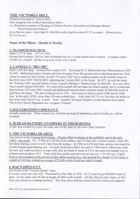
Ceremonial object - Invitation, City of Bendigo, The Freedom of Entry, 1970
On the 27th March, 1942 'Fortuna House' was occupied by LHQ Cartographic Company, Australian Survey Corps. Fortuna was the site of the base map plant and during this time approximately sixteen million maps of Australian Territories in the South West Pacific area were produced for use by the Allied Services. Fortuna was purchased in 1951 by the Commonwealth Government and until 1970 the Survey Corps and Regiment became part of community life in the district. This event to grant the Regiment Freedom of Entry took place at the Queen Elizabeth Oval on Sunday 14th June, 1970.Booklet outlining the celebrations commemorating the Army Survey Regiment's time in Bendigo. Includes a short history of the Regiment's association with the City which spanned from 1942 - 1970 as well as the day proceedings attended by the Mayor and Councillors.fortuna house, george lansell, royal aust survey corps, queen elizabeth oval, mayor jeffrey -
University of Melbourne, Burnley Campus Archives
Plan, Glenferrie PR. S. No. 1508: Detail Survey, 1982
Original and 2 copies of Public Works Department, Victoria plans of Glenferrie Primary School for the Department of Education SU 2241.2. Shows site plan of area bounded by Manningtree Road and Wattle Road. Pit Schedule of storm water and sewer pits.glenferre primary school, survey, victoria public works department, storm water, trees, p. manley (draftsman) -
 Ballarat Heritage Services
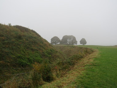
Photograph - Photograph - Colour, Earth Banks, Old Sarum, England, 01 November 2016
William the Conqueror inherited Old Sarum from the last Saxon king of England. It was an ideal site for a royal castle. It was here in 1070 that William paid off his army after a long and bitter campaign in northern England. It was here in 1086 that he called together all the major landholders in England so they could swear allegiance to him. It was a crucial moment. The Domesday Book was being written, a threatened Viking invasion had only just been averted and William's eldest son was in armed rebellion. Old Sarum was an important place where this Norman king of England held power. In 1794 the Ordnance Survey set out to check the accuracy of the first mapping of Southern England, which had begun ten years earlier. From a point just below Old Sarum Lieutenant William Mudge laid out a base-line 36,574 feet (11,253 metres) long. From each end of the line the positions of distant places were plotted using a huge theodolite made in 1791 by Jesse Ramsden. The accuracy of the process, which was repeated all over England, depended on Jesse Ramsden's craftsmanship and on William Mudge's surveying skill in setting out this first base-line from Old Sarum. The nearer end of Mudge's line is marked by an inscribed stone beside the modern A345 at Old Sarum. Colour photograph of Earth Banks, Old Sarum, Englandordnance survey, william mudge, jesse ramsden, william the conqueror, old sarum, saxon, 1086, england -
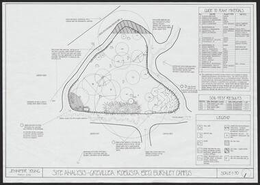 University of Melbourne, Burnley Campus Archives
Plan, Jennifer Young, Grevillea Robusta Bed Burnley Campus, 2006
(1) Site Analysis by Jennifer Young, March 2006. (2) Plant Survey by Jennifer Young, March 2006. (3) Plant Plan - photocopy of rough hand-drawn planjennifer young, grevillea robusta, burnley horticultural college, landscaping, soil types -
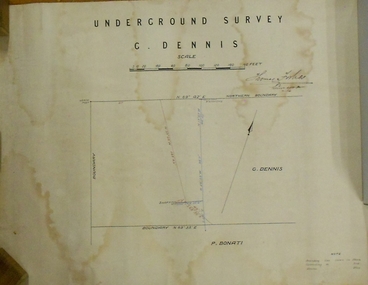 Bendigo Historical Society Inc.
Plan - MARKS COLLECTION: PLAN OF UNDERGROUND SURVEY G. DENNIS MINE
Plan drawn on heavy parchment 'underground survey G. Dennis' printed on top of plan. Plan shows boundary lines and peg site. P. Bonati claim marked on bottom of plan. B. Letter with plan on letterhead 'City of Sandhurst, Town Hall, July 2nd. 1873' Addressed to Mr. George Dennis, Sir, In reply to your letter of the 19th. ulto I am empowered to state that subject to the formation of the road referred to, your existing rights are conserved, and the council will undertake not to object to the renewal of your lease. The only conditions being that you shall not sink a shaft in the street or attempt to obstruct it when formed. I have the honor to be, Sir, your obedient servant, Geo Fletcher, Town Clerk.bendigo, mining, g. dennis claim -
University of Melbourne, Burnley Campus Archives
Plan, Horticultural & Experimental Garden in the Survey Paddock Richmond, 1862
Plan of site with area drawn in. From Office Dept. of Natural Resources.Handwritten on original: "To accompany letter from the Hon. Sec. of the Horticultural Society of Victoria to the Hon. The President of the Board of Land Works. A. Purchas, C.E. 9 October 1862 R 19 A1." and "Memo: The trees to be planted 50 feet apart in each row. AP"burnley, horticultural society of victoria