Showing 285065 items
matching streets,roads,melbourne,map,melway
-
 Whitehorse Historical Society Inc.
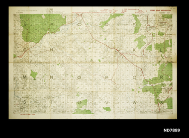
Map - WW1 map of France, WW1 map of France - regional. Field Survey Map of Enemy Rear Organisation, 08/10/1918
Enemy Rear Organisation map Scale 1 : 40,000Field Survey Map of Enemy Rear Organisationnon-fictionEnemy Rear Organisation map Scale 1 : 40,000maps, world war 1914 - 1918 -
 Whitehorse Historical Society Inc.
Map, Map of Mitcham, 1916?
Copy of early map of Mitcham.Copy of early map of Mitcham showing main roads and large blocks of land with owners' namesCopy of early map of Mitcham. mitcham road mitcham, heatherdale road mitcham, whitehorse road mitcham, morton, william, ainger, f, morgan, r. r., harding, w, sergeant, r, mcclelland, john, wilson, w, cook, j -
 Kew Historical Society Inc
Plan, Melbourne & Metropolitan Board of Works : Borough of Kew : Detail Plan No.1561, 1905
The Melbourne and Metropolitan Board of Works (MMBW) plans were produced from the 1890s to the 1950s. They were crucial to the design and development of Melbourne's sewerage and drainage system. The plans, at a scale of 40 feet to 1 inch (1:480), provide a detailed historical record of Melbourne streetscapes and environmental features. Each plan covers one or two street blocks (roughly six streets), showing details of buildings, including garden layouts and ownership boundaries, and features such as laneways, drains, bridges, parks, municipal boundaries and other prominent landmarks as they existed at the time each plan was produced. (Source: State Library of Victoria). This plan forms part of a large group of MMBW plans and maps that was donated to the Society by Mr Poulter, City Engineer of the City of Kew in 1989. Within this collection, thirty-five hand-coloured plans, backed with linen, are of statewide significance as they include annotations that provide details of construction materials used in buildings in the first decade of the 20th century as well as additional information about land ownership and usage. The copies in the Public Record Office Victoria and the State Library of Victoria are monochrome versions which do not denote building materials so that the maps in this collection are invaluable and unique tools for researchers and heritage consultants. A number of the plans are not held in the collection of the State Library of Victoria so they have the additional attribute of rarity.Original survey plan, issued by the MMBW to a contractor with responsibility for constructing sewers in the area identified on the plan within the Borough of Kew. The plan was at some stage hand-coloured, possibly by the contractor, but more likely by officers working in the Engineering Department of the Borough and later Town, then City of Kew. The hand-coloured sections of buildings on the plan were used to denote masonry or brick constructions (pink), weatherboard constructions (yellow), and public buildings (grey). MMBW Detail Plan 1561 outlines those residences in the area bordered by Burke Road, Loxton Street, Mount Street and Barkers Road that had been constructed by 1905 when the land was surveyed. At this time, the area nearest Burke Road had been subdivided and developed whereas the lands to the west were as yet undeveloped. The houses represented are not named on the Plan.melbourne and metropolitan board of works, detail plans, mmbw 1561, cartography -
 Greensborough Historical Society
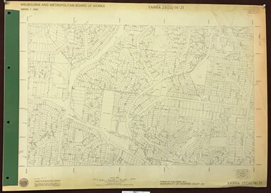
Map, Melbourne and Metropolitan Board of Works. Survey Division, MMBW, Yarra 2500 / 13.26. Yarrambat, Worns Lane, 1978_02
Melbourne and Metropolitan Board of Works. Yarra 2500 [base map] 13.26. Yarrambat, Worns Lane. Municipalities of Diamond Valley 257 and Whittlesea 239. Prominent streets include: Worns Road, North Oatlands Road and Licola Street. Features include Plenty River.MMBW Map in 1:2500 [scale] series. Cream parchment with green tape reinforcing on edges and punched holes on left edge.mmbw, melbourne and metropolitan board of works, shire of diamond valley, whttlesea, yarrambat - maps -
Hume City Civic Collection
Book - Street Directory, Gregory"s Melbourne Street Directory
... Roads ...This 1972 Gregory's Melbourne Street Directory published by Gregory's Guides & Maps Pty Ltd was used by the donor, her husband and family.A black leather removable cover with gold embossed vintage car on the front enclosing a Gregory's Melbourne Street Directory.Gold embossed vintage car on front cover.joan houston, maps, street directory, roads, suburbs -
Port Melbourne Historical & Preservation Society
Document - Photocopy, maps, 1890s maps, 30 April 1890 .01 11 March 1890 .02
.01 Copy of Map 3084B - Port Melbourne, Willamstown Road to Esplanade East; to Graham Street; to Boundary Road & Pickles Street. .02 Copy of map of Port Melbourne, Bay Street to Clark Street; to Foreshore; to Pickle Street & Spring Street..01 for title information see parcels index 47,53,54,55,56 & 57. .02 Parcels index 3084-B 16 (City of Port Melbourne)built environment - commercial, built environment - domestic, city of port melbourne, parish of south melbourne -
 Kew Historical Society Inc
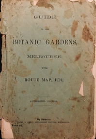
Booklet, Robert S Brain, Guide to the Botanic Gardens Melbourne, with Route Map etc, 1901
Authorised guide to the Botanic Gardens, Melbourne published by the Government Printer, Victoria. Includes three fold out pages, the first a panoramic photograph, the second a colour map of the Botanic Gardens in 1873 upon the retirement of Baron Von Mueller from the Directorship in 1873 and the third a map of the Botanic Gardens in 1901 showing alterations and improvements since 1873 by W.R. Guilfoyle, Director..Melbourne : Robt. S. Brain, Govt. Printer, [1901] 19 p., [3] folded leaves of plates : ill., plans ; 21 cm. non-fictionAuthorised guide to the Botanic Gardens, Melbourne published by the Government Printer, Victoria. Includes three fold out pages, the first a panoramic photograph, the second a colour map of the Botanic Gardens in 1873 upon the retirement of Baron Von Mueller from the Directorship in 1873 and the third a map of the Botanic Gardens in 1901 showing alterations and improvements since 1873 by W.R. Guilfoyle, Director..botanic gardens -- melbourne (vic.), christian-washfold collection -
 Melbourne Tram Museum
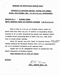
Document - Memorandum, Melbourne & Metropolitan Tramways Board (MMTB), "Procession of Munitions Vehicles, through city streets", Oct. 1943
... "Procession of Munitions Vehicles, through city streets" ...2 copies of letter from HS Wootton, Town Clerk, City of Melbourne, titled "Arrangements in connection with "Miles of Munitions 1943" procession through city streets on Friday 29th October, 1943, in connection with Fourth Liberty War Loan". Provides details of route and assembly points with tram requirements. Dated 21 Oct 1943 8 memos from JM Harry, Dist Traffic Supt SS regarding tram arrangements to various inspectors. Memos dated 27/10/1943."Mr Harry" written in pencil on one letter. "Coburg depot" written on 2 memos. Several comments written in pencil regarding tram scheduling.trams, tramways, events, parades, world war 2, coburg depot, hanna st depot, malvern depot, hawthorn depot, camberwell depot, glenhuntly depot, victoria st, swanston st, elizabeth st, spencer st, collins st -
 Greensborough Historical Society
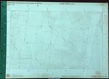
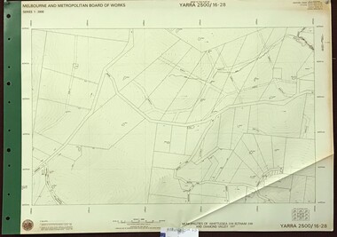
Map, Melbourne and Metropolitan Board of Works. Survey Division, MMBW, Yarra 2500 / 15.26. Yarrambat, Hacketts Road, 1978_07
Melbourne and Metropolitan Board of Works. Yarra 2500 [base map] 15.26. Yarrambat, Hacketts Road. Municipality of Diamond Valley 257. Prominent streets include: Black Gully Road, Hacketts Road and Collins Lane. Features include Scrubby Creek.MMBW Map in 1:2500 [scale] series. Cream parchment with green tape reinforcing on edges and punched holes on left edge.mmbw, melbourne and metropolitan board of works, shire of diamond valley, yarrambat - maps -
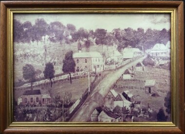 Greensborough Historical Society
Photograph - Photograph (Framed), St Helena and Diamond Creek Roads Greensborough 1889, 1889
... St Helena and Diamond Creek Roads Greensborough 1889 ...A view of Greensborough township 1889, painted from the corner of St Helena Road and Diamond Creek Roads. This copy has been cropped from the original to show lower Main Street and Marble hall. The original of this painting is owned by Greensborough Primary School.From the John Mackey collection. this item was displayed at the offices of Ryan, Mackey and Kelly, solicitors, Main Street Greensborough.Small timber-framed photograph of road and houses, sepia.greensborough, main street greensborough, marble hall greensborough, arthur elliott, john mackey -
 Greensborough Historical Society
Map, Melbourne and Metropolitan Board of Works. Survey Division, MMBW, Yarra 2500 / 11.21. Bundoora, east of Plenty Road, 1979_01
Melbourne and Metropolitan Board of Works. Yarra 2500 [base map] 11-21. Bundoora, east of Plenty Road. Parish of Keelbundoora 2856, Municipalities of Diamond Valley 257, Preston 225 and Whittlesea 239. Prominent streets include: Grimshaw Street, Settlement Road and Plenty Road. Includes Yulong Park.MMBW Map in 1:2500 [scale] series. Cream parchment with green tape reinforcing on edges and punched holes on left edge.mmbw, melbourne and metropolitan board of works, shire of diamond valley, bundoora - maps -
 Kew Historical Society Inc
Plan, Melbourne & Metropolitan Board of Works : Borough of Kew : Detail Plan No.1296, 1904
The Melbourne and Metropolitan Board of Works (MMBW) plans were produced from the 1890s to the 1950s. They were crucial to the design and development of Melbourne's sewerage and drainage system. The plans, at a scale of 40 feet to 1 inch (1:480), provide a detailed historical record of Melbourne streetscapes and environmental features. Each plan covers one or two street blocks (roughly six streets), showing details of buildings, including garden layouts and ownership boundaries, and features such as laneways, drains, bridges, parks, municipal boundaries and other prominent landmarks as they existed at the time each plan was produced. (Source: State Library of Victoria)This plan forms part of a large group of MMBW plans and maps that was donated to the Society by the Mr Poulter, City Engineer of the City of Kew in 1989. Within this collection, thirty-five hand-coloured plans, backed with linen, are of statewide significance as they include annotations that provide details of construction materials used in buildings in the first decade of the 20th century as well as additional information about land ownership and usage. The copies in the Public Record Office Victoria and the State Library of Victoria are monochrome versions which do not denote building materials so that the maps in this collection are invaluable and unique tools for researchers and heritage consultants. A number of the plans are not held in the collection of the State Library of Victoria so they have the additional attribute of rarity.Original survey plan, issued by the MMBW to a contractor with responsibility for constructing sewers in the area identified on the plan within the Borough of Kew. The plan was at some stage hand-coloured, possibly by the contractor, but more likely by officers working in the Engineering Department of the Borough and later Town, then City of Kew. The hand-coloured sections of buildings on the plan were used to denote masonry or brick constructions (pink), weatherboard constructions (yellow), and public buildings (grey). This area was once known as O’Shaughnessy’s Paddock. O’Shaughnessy was the licensee of the Kew Hotel. The ‘Paddock’ or farm was for many years the closest farm to Melbourne. By 1903, when this plan was surveyed and lithographed, little of the farm remained. The area is dominated by a ‘clay hole’, on the site of the current Foley Reserve. It was used by Smart’s Brickyard from the 1880s until 1911, when the Council purchased it for a rubbish dump. It is notable as the site is one of the few industrial operations to have existed in Kew. By 1903, urban development was characterised by larger houses fronting Barkers Road and brick and weatherboard villas in Foley Street. Nearer the pit, weatherboard houses predominated. Foley Street bisected the triangular block and continued right to Denmark Street. At this stage, a house impeded the through road, only allowing access via a right of way to High Street.melbourne and metropolitan board of works, detail plans, mmbw 1296, cartography -
 Greensborough Historical Society
Map, Melbourne and Metropolitan Board of Works. Survey Division, MMBW, Yarra 2500 / 16.22. Research, 1979_05
Melbourne and Metropolitan Board of Works. Yarra 2500 [base map] 16-22. Research. Parish of Nillumbik 3310. Municipalities of Diamond Valley 257 and Eltham 238. Prominent streets include: Orme Road and Allendale Road. MMBW Map in 1:2500 [scale] series. Cream parchment with green tape reinforcing on edges and punched holes on left edge.mmbw, melbourne and metropolitan board of works, shire of diamond valley, diamond creek - maps -
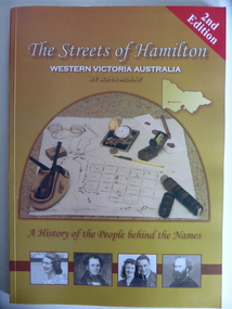 Warrnambool and District Historical Society Inc.
Book, Streets of Hamilton, 2007 (revised and reprinted 2009)
... Streets of Hamilton ...This is a book providing information on the streets of Hamilton, Victoria and the origin of the names. Hamilton is a city in Western Victoria at the intersection of the Glenelg Highway and the Henty Highway. European settlement began with the arrival of pastoralists following the 1836 explorations of Major Thomas Mitchell. The Wedge family in 1839 had the property ‘The Grange’ which covered the site of Hamilton today. The town was gazetted in 1851 and named after a place in Scotland. Hamilton Victoria is the centre of a sheep-grazing and agricultural district. The book won an award in the 2008 Victorian Community History Awards. This book is of interest as it gives information on the Hamilton streets and the origin of their names. The history of Hamilton is of particular interest to those also living in the Western District. The book will be a useful research tool. This is a soft cover book of 174 pages. The back cover has a white background with black and white photographs of five local Hamilton people. The front cover has a yellow and brown background with black and white photographs of five local Hamilton people, an outline of a map of Victoria and a photograph of a map of the Hamilton area with some artefacts placed on the map. The book contains an Introduction, a Preface, a Foreword, an Early Days Overview, a list of Contents, a list of the streets in alphabetical order with information on the origin of the names, two Appendices and an Index. The book has many black and white photographs and sketches. Front Cover: ‘2nd Edition’ ‘The Streets of Hamilton’ ‘Western Victoria Australia’ ‘By John McKay’ ‘A History of the People behind the Names’hamilton, victoria, john mckay, street names of hamilton, warrnambool -
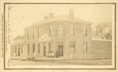 Bacchus Marsh & District Historical Society
Photograph, Royal Hotel corner of Main and Young Streets Bacchus Marsh 1883
... Royal Hotel corner of Main and Young Streets Bacchus Marsh ...This image is one of a series of photographs taken by Melbourne based photographers Stevenson and McNicoll who visited Bacchus Marsh nearby districts between September and November 1883. The Royal Hotel was built in 1861 and is located on the corner of Main and Young Streets in Bacchus Marsh. The first owner was James Murray and the hotel was first known as the Murray Family Hotel. James Murray died in an accident in 1863 and sometime after this the ownership passed to Richard Manning. From around 1869 it became known as the Royal Hotel. Richard Manning's son Frederick Manning inherited the hotel in 1896. The Manning family owned the hotel until sometime after 1945. In more recent decades it has been owned and operated by a number of different people. The hotel continues to operate as of 2024. This image shows the building in its original structure. In 1888, five years after this image was taken, a second storey was added to the section on Young Street. In this image this section is the single storey section of wall without windows to the right of the picture. Small sepia 'carte de viste' style unframed photograph on card with gold border framing photograph. Housed in the album, 'Photographs of Bacchus Marsh and District in 1883 by Stevenson and McNicoll'. The image shows the Royal Hotel seen from the intersection of Main and Young Streets. The diagonal view shows both the Main Street and Young Street sides of the building. It is a two storey brick building with a single storey brick extension on the Young Street frontage. Standing at the corner of the building is a woman and five girls. A deep gutter runs along the Main Street, with a pedestrian crossing ramp. Over this crossing point, there is a large metal frame bearing an ornate lantern. Next to it is a water trough for horses. Several hitching posts can be seen along the footpaths.Printed On the front: Stevenson & McNicoll. Photo. 108 Elizabeth St. Melbourne. COPIES CAN BE OBTAINED AT ANY TIME. On the back: LIGHT & TRUTH inscribed on a banner surmounted by a representation of the rising sun. Copies of this Portrait can be had at any time by sending the Name and Post Office Money Order or Stamps for the amount of order to STEVENSON & McNICOLL LATE BENSON & STEVENSON, Photographers. 108 Elizabeth Street, MELBOURNE. stevenson and mcnicoll 1883 photographs of bacchus marsh and district, hotels bacchus marsh, royal hotel bacchus marsh, manning family bacchus marsh, murray family hotel bacchus marsh -
 Greensborough Historical Society
Map, Melbourne and Metropolitan Board of Works. Survey Division, MMBW, Yarra 2500 / 15.22. Eltham North. Allendale Road, 1979_08
Melbourne and Metropolitan Board of Works. Yarra 2500 [base map] 15.22. Eltham North, Allendale Road. Parish of Nillumbik. Municipalities of Eltham 238 and Diamond Valley 257. Prominent streets include: Allendale Road, Godber Road and Ryans Road. Features include the Diamond Creek.MMBW Map in 1:2500 [scale] series. Cream parchment with green tape reinforcing on edges and punched holes on left edge.mmbw, melbourne and metropolitan board of works, shire of diamond valley, nillumbik, eltham - maps -
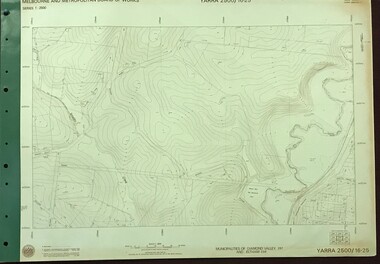
 Greensborough Historical Society
Map, Melbourne and Metropolitan Board of Works. Survey Division, MMBW, Yarra 2500 / 16.26. Diamond Creek, Broadgully Road, 1978_07
Melbourne and Metropolitan Board of Works. Yarra 2500 [base map] 16.26. Diamond Creek, Broad Gully Road. Municipalities of Diamond Valley 257 and Eltham 238. Prominent streets include: Wadeson Road, Broad Gully Road and Glenhaven Road. Features include the Diamond Creek.MMBW Map in 1:2500 [scale] series. Cream parchment with green tape reinforcing on edges and punched holes on left edge.mmbw, melbourne and metropolitan board of works, shire of diamond valley, diamond creek - maps -
 Orbost & District Historical Society
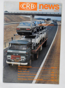
magazine, CRB News, August 1975
... Country Roads Board ...The Country Roads Board was the government authority for the construction and maintenance of main roads in Victoria between 1913 and 1983. It was succeeded by the Road Construction authority on 1 July 1983 and later merged with the Road Traffic Authority on July 1 1989 to form the Roads Corporation. James Cameron, an Orbost farming pioneer and Member of the Legislative Assembly, fathered the Country Roads Board.This item is a useful research source on the Princes Highway, Gippsland.A 19 pp magazine, titled CRB ( Country Roads Board) News. It is dated August 1976. On the front cover is a coloured photograph of a truck carrying cars. In the background is a road bridge. It contains an article on the Princes Highway, Gippsland.magazine journal-crb-news princes-highway -
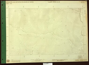
 Greensborough Historical Society
Map, Melbourne and Metropolitan Board of Works. Survey Division, MMBW, Yarra 2500 / 16.25. Wattle Glen, 1978_07
Melbourne and Metropolitan Board of Works. Yarra 2500 [base map] 16-25. Wattle Glen. Municipalities of Diamond Valley 257 and Eltham 238. Prominent streets include: Nimmo Road, Broad Gully Road and Heidelberg-Kinglake Road. Includes Yulong Park.MMBW Map in 1:2500 [scale] series. Cream parchment with green tape reinforcing on edges and punched holes on left edge.mmbw, melbourne and metropolitan board of works, shire of diamond valley, wattle glen - maps -
 Warrnambool and District Historical Society Inc.
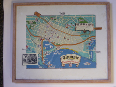
Advertising, Tourist Map of Warrnambool (framed x 2), 1950s
These framed tourist maps came from the Lane Foundation so it is presumed that they were from the office of Lane’s Travel Service which operated from 205 Raglan Parade Warrnambool with the known dates, the 1950s and 1960s. The proprietor, Alan Lane, was a successful Warrnambool businessman who operated a Warrnambool and district bus service as well as his travel business. He was heavily involved in local community affairs being a Warrnambool Councillor for 18 years from 1952 to 1970 and President of the Warrnambool Chamber of Commerce for six years. He was a major donor to the Warrnambool Performing Arts Centre, the Warrnambool Art Gallery and the St. John of God Hospital and left the bulk of his estate to the Alan Lane Foundation which has contributed millions of dollars to local organizations and programs. Alan Lane died in 1995. These framed maps are of some interest as examples of the tourism maps used to promote the city and district in the 1950s and 60s. This is a tourist map of the Warrnambool C.B.D. and adjoining streets produced as an advertisement for Olympic Tyres. It is multi-coloured and has cartoon sketches of the main tourist attractions and pointers to attractions outside of the main city area. It includes an inset black and white photograph of the Warrnambool Botanic Gardens and an advertisement for Olympic Tyres. It is printed on a white background and is enclosed behind glass in a wooden frame of a light brown colour. It has a wire at the back for attachment to a wall. ‘Warrnambool – 163 miles from Melbourne – a popular tourist resort offering many holiday attractions – an ideal surfing beach with all modern facilities is avalable’ ‘Fit Olympic Tyres, Champions of the Road’ alan lane foundation, warrnambool tourism -
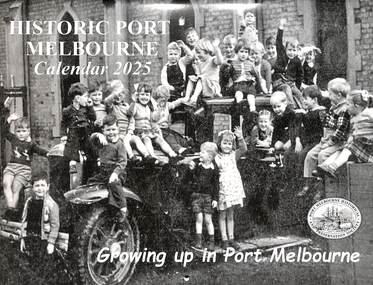 Port Melbourne Historical & Preservation Society
Document - Calendar 2025, Port Melbourne Historical & Preservation Society members, Historic Port Melbourne -Growing Up in Port Melbourne, October 2024
Researched, written and designed by PMHPS members.The cover of the 2025 "Historic Port Melbourne -Growing up in Port Melbourne " shows a group of children in 1957, on and in a car at the Presbyterian Church Kindergarten, Bridge Street Port Melbourne. The calendar was produced by members of the Port Melbourne Historical & Preservation Society and focuses on children's experiences growing up in Port Melbourne in the 1920's to the 1950's.education - kindergartens, education - primary schools, sport - football, sport - cricket, frank vincent, george langley, entertainment - celebrations -
 Greensborough Historical Society
Map, Melbourne and Metropolitan Board of Works. Survey Division, MMBW, Yarra 2500 / 14.21. St Helena, Weidlich Road, 1979_08
Melbourne and Metropolitan Board of Works. Yarra 2500 [base map] 14.21. St Helena, Weidlich Road. Parish of Nillumbik 3310. Municipality of Diamond Valley 257. Prominent streets St Helena Road, Weidlich Road, Karingal Drive and Progress Road. Features include the Blair Reserve.MMBW Map in 1:2500 [scale] series. Cream parchment with green tape reinforcing on edges and punched holes on left edge.mmbw, melbourne and metropolitan board of works, shire of diamond valley, st helena - maps -
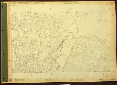
Port Melbourne Historical & Preservation Society
Map, City of Port Melbourne, Oct 1963
Gives a visual understanding of the Port Melbourne area in 1963A detailed map of the Port Melbourne area in October 1963. Details roads and laneways, undeground cables, light and power poles, sewer, bridges, piers reserve and park areas.local government, built environment, piers and wharves, natural environment - beaches and foreshore, parks and gardens, piers and wharves - princes pier, piers and wharves - station pier, engineering - roads streets lanes and footpaths, engineering - canals and drainage -
 Melbourne Tram Museum
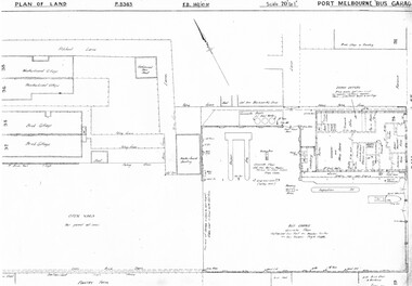
Drawing, Melbourne & Metropolitan Tramways Board (MMTB), "Port Melbourne Bus Garage", c1938
Set of five photocopied plans or drawings on A3 sheets of the "Port Melbourne Bus Garage" .1 - P8383 - Plan showing building layouts and adjacent land - including a Poultry Farm - dated 1938 .2 - P8416 - Plan showing parts of the adjoining properties including houses. .3 - Unnumbered - more modern architects drawing showing details of offices - c1944? - two sheets. .4 - unnumbered - drawing showing layout of repair shed, pits, offices and mess room facing Bay St. Copy of the map from Melway Street Directory No. 1 from Kevin Staines 24-2-2018 - added 9-3-2018. See image i6trams, tramways, drawings, depots, property, port melbourne, buses, maps -
 Greensborough Historical Society
Map, Melbourne and Metropolitan Board of Works. Survey Division, MMBW, Yarra 2500 / 16.28. East of Hurstbridge, 1977_10
Melbourne and Metropolitan Board of Works. Yarra 2500 [base map] 16.28. East of Hurstbridge. Municipalities of Whittlesea 239, Eltham 238 and Diamond Valley 257. Prominent streets include: Boyds Road, Bannons Lane and Wattle Tree Road. MMBW Map in 1:2500 [scale] series. Cream parchment with green tape reinforcing on edges and punched holes on left edge.mmbw, melbourne and metropolitan board of works, shire of diamond valley -
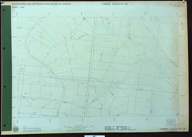
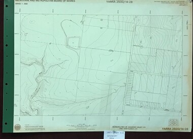 Greensborough Historical Society
Map, Melbourne and Metropolitan Board of Works. Survey Division, MMBW, Yarra 2500 / 14.28. Yarrambat Park, 1977_09
Melbourne and Metropolitan Board of Works. Yarra 2500 [base map] 14.28. Yarrambat Park. Municipalities of Diamond Valley 257 and Whittlesea 239. Prominent streets include: Bannons Road and Yan Yean Road. Features include the Plenty River.MMBW Map in 1:2500 [scale] series. Cream parchment with green tape reinforcing on edges and punched holes on left edge.mmbw, melbourne and metropolitan board of works, shire of diamond valley, whttlesea, yarrambat - maps -
 Greensborough Historical Society
Map, Melbourne and Metropolitan Board of Works. Survey Division, MMBW, Yarra 2500 / 14.25. Plenty, Heard Road, 1978_02
Melbourne and Metropolitan Board of Works. Yarra 2500 [base map] 14.25. Plenty, Heard Road. Parishes of Greensborough 2724, Nillumbik 3310 and Morang 3183. Municipality of Diamond Valley 257. Prominent streets include: Heard Road, Seymour Drive and Yan Yean Road.MMBW Map in 1:2500 [scale] series. Cream parchment with green tape reinforcing on edges and punched holes on left edge.mmbw, melbourne and metropolitan board of works, shire of diamond valley, plenty - maps -
 Melbourne Tram Museum
Letter, Melbourne & Metropolitan Tramways Board (MMTB), Parade of RAN personnel through city streets, Thursday 21 October 1943, Oct. 1943
... Parade of RAN personnel through city streets, Thursday 21 ...Parade of RAN personnel through city streets, Thursday 21 October 1943 Letter from GJ Dean, Acting Town Clerk, City of Melbourne, describing arrangements for the parade. Dated 9th October 1943. 2 memos from JM Harry, Dist Traffic Supt SS regarding tram arrangements to Mr Bell, Asst Per Way Engineer and Depot Masters. Memo from JM Harry, Dist Traffic Supt SS to Assistant Manager regarding shunting operations. Memos dated 18th & 19th October 1943.Notations written in blue pencil on letter., "City March - Thurs 21/10/43" written in red penciltrams, tramways, events, ymca, st kilda rd, sturt st -
 Ringwood and District Historical Society
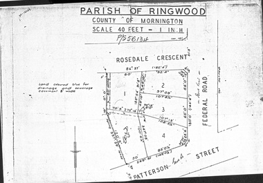
Document - Folder, Map of Subdivision for auction - Ringwood East, Vic., 1973
Photocopy of Parish Map showing five residential blocks for sale on Rosedale Crescent, Federal Road and Patterson Street Ringwood East.Accompanying handwritten sales notes researched in 2024 by Richard Carter - Carter Real Estate - "5 lots (heavily filled) auction 14 July 1973. All later sold $4000 each - unknown agent". -
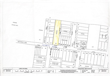 Whitehorse Historical Society Inc.
Map, 125 Separation Street, Northcote. Cadastral Map, 21/11/2001
A3 Cadastral Map of 125 Separation Street, Northcote August Schwerkolt purchased this property on 01/08/1853 where he lived and farmed the land, eventually purchasing the Mitcham property as well in 1861An A3 cadastral mapschwerkolt august