Showing 375 items
matching subdivision map
-
 Whitehorse Historical Society Inc.
Document - Leaflet, Blackburn Land Sale, 19/11/1910 12:00:00 AM
Pamphlets showing sale of land Gardenia Street, Blackburn and surrounding streets.Pamphlets showing sale of land Gardenia Street, Blackburn and surrounding streets. Schedule of prices. Hand drawn mapPamphlets showing sale of land Gardenia Street, Blackburn and surrounding streets.blackburn township estate co. ltd., blackburn railway station, south parade blackburn, laburnum street, blackburn, the avenue blackburn, fuschia street blackburn, linum street blackburn, main street, t.r.b.morton. & son, land subdivision -
 Whitehorse Historical Society Inc.
Map, Austral Park, Mitcham, 1907
Advertisement for subdivision of area south of Mitcham Railway Station.Advertisement for subdivision of area south of Mitcham Railway Station. Includes area now site of Mitcham reservoir. Some details of main buildings in Mitcham and Vermont.Advertisement for subdivision of area south of Mitcham Railway Station. land subdivision, mitcham, mitcham road, mitcham, calcutta street, mitcham, delhi street, mitcham, meerut street, mitcham, simla street, mitcham, agra street, mitcham, lucknow street, mitcham, mitcham reservoir, austral park mitcham -
Whitehorse Historical Society Inc.
Map, Plan of the Parish of Nunawading, 1853
Photocopy of map showing names of selectors, also list of references to the corners of allotments.Photocopy of map showing names of selectors, also list of references to the corners of allotments. Note on verso:'Gardiners Creek, Ballyshanassey township surveyed by H. Parmein, Surveyor General's Office Nov 30, 1853 also Reference to the Corners of allotments' (Plan 428)Photocopy of map showing names of selectors, also list of references to the corners of allotments. land subdivision, gardiners creek, ballyshanassy, parmein, h, burwood east, maps -
Whitehorse Historical Society Inc.
Map, The Parish of Nunawading, 1853
... holes and terrain indicated. Land Subdivision Maps Parish ...Photocopy of manuscript plan with allotments numbered and some named.Photocopy of manuscript plan with allotments numbered and some named. Note on verso: The Parish of Nunawading in the County of Bourke; lithographed at the Surveyor General's office by J.Jones Jan 18th 1853. Endorsed Sale Plan 271. Dray tracks, water holes and terrain indicated.Photocopy of manuscript plan with allotments numbered and some named. land subdivision, maps, parish of nunawading, jones, j -
Whitehorse Historical Society Inc.
Map, The Mascot Estate, Blackburn, 1924
Advertisement for auction of land between the railway line and Whitehorse Road in Blackburn.Advertisement for auction of land between the railway line and Whitehorse Road in Blackburn. Includes photos of houses in the neighbourhood. Auction by H. Pallyn & Co and Frank Fisher in conjunction. Street names have changed to Ceylon Street and Terracotta Drive.Advertisement for auction of land between the railway line and Whitehorse Road in Blackburn. land subdivision, whitehorse road, blackburn, simla street, mitcham, king street, blackburn, iona street, blackburn, ceylon street, blackburn, terracotta drive, blackburn, mascot estate, blackburn -
Whitehorse Historical Society Inc.
Map, Subdivision of Allotment 122a, 1972
... . Two maps in different scales. Subdivision of Allotment 122a ...Subdivision of land along Livermore Close and Moore Road, Vermont South.Subdivision of land along Livermore Close and Moore Road, Vermont South. Original survey Rob Poole 1899. Stamp indicates 'Land on this plan is in proclaimed survey No 21. Survey Coordination Act 1940. As from 9 Aug 1972. Two maps in different scales.Subdivision of land along Livermore Close and Moore Road, Vermont South. land subdivision, livermore close, vermont south, moore road, vermont south, dandenong creek -
Whitehorse Historical Society Inc.
Map, Gill's Springfield Road Estate, 1950?
Plan of subdivision for Gill's Springfield Road Estate, former orchard, 16 lots.Plan of subdivision for Gill's Springfield Road Estate, former orchard, 16 lots. Reprinted by Real Estate Agent, Spencer Jackson.Plan of subdivision for Gill's Springfield Road Estate, former orchard, 16 lots. land subdivision, norway avenue, blackburn, springfield road, blackburn, beverley crescent, blackburn, kevin avenue, blackburn, kerr street, blackburn, bordeaux avenue, blackburn, gill's estate, orchards, spencer jackson -
 Whitehorse Historical Society Inc.
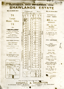
Document, Shawlands Estate, 22/11/1924 12:00:00 AM
Notice of Sale of land Holland Road and Canterbury RoadNotice of Sale of land Holland Road and Canterbury Road Blackburn Original in Haughton Maps LaTrobe LibraryNotice of Sale of land Holland Road and Canterbury Road land subdivision, canterbury road, blackburn south, holland road, shawlands avenue, coghill & haughton, shawlands estate, haughton map collection, state library of victoria. latrobe library -
Whitehorse Historical Society Inc.
Legal record - Land Title, Musk Street, Blackburn
Land Titles referring to No. 1 Musk Street, BlackburnLand Titles referring to No. 1 Musk Street, Blackburn : 1. Vol. 542 Fol. 108222, James William Barnes, 1872; 2. Vol. 1877, Fol. 375367, Freehold Investment and Banking Company of Australia Limited, 1886; 3. Transfer 1507851 to John Thomas Williams, 1932; 4. Vol. 8109 Fol. 997 William Henry Rogers, 1955, with Plan of Subdivision CP 21670; 5. cadastral map, AMA zone 55, Sep 2000.Land Titles referring to No. 1 Musk Street, Blackburn musk street, blackburn, no. 1, maple street, blackburn, lawson street, blackburn, elder street, blackburn, barnes, james william, freehold investment and banking company of australia ltd, springfield road, blackburn, whitehorse road, blackburn, barnes estate -
 Whitehorse Historical Society Inc.
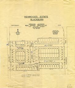
Map, Henwoods Estate, Blackburn
Plan of subdivision in Blackburn SouthPlan of subdivision in Blackburn South between Holland Road and Blackburn Road. Estate advertised by Spencer Jackson, 341 Collins Street.Plan of subdivision in Blackburn South land subdivision, henwoods estate, blackburn south, holland road, brazeel street, marama street, blackburn road, gissing street, hearty street -
Whitehorse Historical Society Inc.
Map, Burwood Road, Box Hill City, 15/02/1952 12:00:00 AM
Plan of subdivision of ten blocks in Burwood Road, Burwood.Plan of subdivision of ten blocks in Burwood Road, Burwood between Milford Avenue and Station Street. Marked as Survey Plan No 5441.Plan of subdivision of ten blocks in Burwood Road, Burwood. land subdivision, burwood road, burwood, milford avenue, burwood, central court, burwood -
Whitehorse Historical Society Inc.
Map, Burwood Road, Box Hill City, 15/02/1952 12:00:00 AM
Plan of subdivision of 19 blocks in Burwood Road, Burwood.Plan of subdivision of 19 blocks in Burwood Road, Burwood between Greenwood Street and Middleborough Road. Marked as Survey Plan No 5442.Plan of subdivision of 19 blocks in Burwood Road, Burwood. land subdivision, burwood road, burwood, greenwood street, burwood, middleborough road, burwood -
 Whitehorse Historical Society Inc.
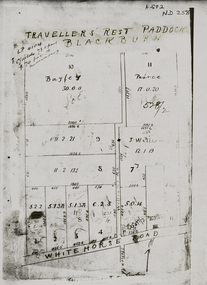
Pamphlet - Map, Travellers Rest Paddock
... subdivision Map of Travelers' Rest Paddock, Blackburn subdivision Map ...Map of Travelers' Rest Paddock, Blackburn subdivisionMap of Travellers Rest Paddock, Blackburn subdivision with frontage in Whitehorse RoadMap of Travelers' Rest Paddock, Blackburn subdivisionwhitehorse road, blackburn, travellers rest paddock, williams road, bayley, leonard sherwin, pearce, land subdivision -
 Whitehorse Historical Society Inc.
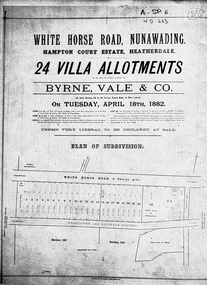
Document, Hampton Court Estate
Plan of subdivision Hampton Court EstatePlan of subdivision Hampton Court Estate Whitehorse Road, Nunawading 1882. Original in Vale Maps LaTrobe LibraryPlan of subdivision Hampton Court Estate hampton court estate, byrne vale & co. -
 Whitehorse Historical Society Inc.
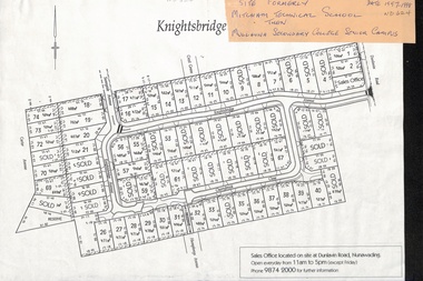
Map, Knightsbridge Estate, Nunawading, Ca 1997 - 1998
Plan of subdivision of former Mitcham Technical School and later Mullauna Secondary College Senior Campus - Knightsbridge Estate.land subdivision, knightsbridge estate, mitcham technical school, mullauna secondary college, senior campus, cherrybrook close, nunawading, knightsbridge avenue, sunnyside avenue, crest grove, dunlavin road, mitcham, carter avenue, humphreys avenue -
Whitehorse Historical Society Inc.
Legal record - Land Title, Certificate of title
... Plastics Limited to De Stoop (Aust) Pty Limited plus maps of some... plus maps of some subdivisions of the estate, 1942. Certificate ...Certificate of Title to Florence Mabel laurie for land in Middleborough Road Blackburn North and transfer of land from Chemical Plastics Limited to De Stoop (Aust) Pty Limited plus maps of some subdivisions of the estate, 1942.Certificate of Title to Florence Mabel laurie for land in Middleborough Road Blackburn North and transfer of land from Chemical Plastics Limited to De Stoop (Aust) Pty Limited plus maps of some subdivisions of the estate, 1942.Certificate of Title to Florence Mabel laurie for land in Middleborough Road Blackburn North and transfer of land from Chemical Plastics Limited to De Stoop (Aust) Pty Limited plus maps of some subdivisions of the estate, 1942.land titles, laurie, florence mabel, chemical plastics limited, de stoop (aust) pty limited, middleborough road blackburn north, koonung creek, chapman street blackburn north, vivian street blackburn north, nestor grove blackburn north, joseph street blackburn north -
 Whitehorse Historical Society Inc.
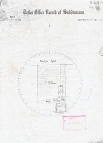
Map, Titles Office Record of Subdivision
... Office Record of Subdivision Titles Office Record of Subdivision ...Titles Office Record of Subdivisionclarkes road, blackburn, whitehorse road -
Whitehorse Historical Society Inc.
Map, Lake Road estate Blackburn, c1960
Plan of subdivision of Lake Road Estate, 36 sites.Plan of subdivision of Lake Road Estate, 36 sites. Agent: Mark Padgett & Co Pty Ltd.Plan of subdivision of Lake Road Estate, 36 sites. lake road estate, blackburn, lake road, blackburn, ottawa avenue, blackburn, anjaya court, blackburn, leons court, blackburn -
Whitehorse Historical Society Inc.
Map, Mason's Paddock, Blackburn, 1919
Mason's Paddock, Blackburn, plan of subdivision, 17 lots, realising auction, Saturday Nov 29, 1919.Mason's Paddock, Blackburn, plan of subdivision, 17 lots, realising auction, Saturday Nov 29, 1919. Agents T.R.B. Morton & Son.Mason's Paddock, Blackburn, plan of subdivision, 17 lots, realising auction, Saturday Nov 29, 1919. t.r.b. morton & son, blackburn, masons paddock, blackburn road, blackburn, masons road, blackburn, canterbury road, blackburn -
Whitehorse Historical Society Inc.
Map, Parkmore Estate, c1958 - 1959
Plan of 'Parkmore' subdivision by Southern Construction Company, 444 lots, c 1958-59.land subdivision, forest hill, parkmore road, forest hill, ranfurlie road, forest hill, ranfurlie court, forest hill, everglade avenue, forest hill, hampshire road, forest hill, quentin street, forest hill, cedar court, forest hill, martin court, forest hill, wandin court, forest hill, inglewood avenue, forest hill, deauville street, forest hill, oberon street, forest hill, vanbrook street, forest hill, husband road, forest hill, springvale road, forest hill, southern construction company -
Whitehorse Historical Society Inc.
Map, Anjaya Court, Blackburn, ca1970
[Plan of] Anjaya Court, Blackburn, Lots 6 - 20and of Leons Court, Lots 21-24. One copy with proposed sewerage plan.anjaya court, blackburn, land subdivision, sewerage and sanitation -
 Whitehorse Historical Society Inc.
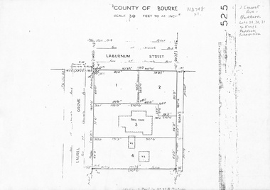
Map, Laurel Grove, 1959
Plan of subdivision, part of Crown Portion 84, Lots 29, 30, 31 Kings Paddock subdivision, cnr Laurel Grove and Laburnum Street, Blackburn. Ref 2713, 6/2/1959.laurel grove, blackburn, laburnum street, land subdivision, kings paddock -
Whitehorse Historical Society Inc.
Map, Township of Norwich, ca 1850
Plan of the Township of Norwich being subdivision of Section III, Parish of Nunawading, County of Bourke, consisting of suburban farms, vineyard sites and town lots, for sale by auction by W. Casey & Co. [c. 1850]. Original in Vale Maps Collection, La Trobe Library.norwich village, vermont, parish of nunawading, vermont south, maps -
Whitehorse Historical Society Inc.
Document - Land Auction and History, Trove Park Drive, Vermont, 1969
Subdivisional land auction documents for Trove Park Drive off Terrara Road, Vermont and history of the site, including maps and photographs.Subdivisional land auction documents for Trove Park Drive of Terrara Road, Vermont and history of the site, including maps and photographs.non-fictionSubdivisional land auction documents for Trove Park Drive off Terrara Road, Vermont and history of the site, including maps and photographs.trove park drive estate vermont, trove park drive vermont, terrara road vermont, uplands vermont, chris round, murray round -
Tatura Irrigation & Wartime Camps Museum
Poster, Subdivision of Township Allotments
... subdivision for sale in the township of Rushworth. Being sold... Darby. Shows map of land subdivision. Subdivision of Township ...Poster depicting the land which was being sold by J S Darby on the 3 December 1890. Auctioneer was Martin Cussen and Co. Map shows location of land.Single sheet of paper, laminated. Advertising land subdivision for sale in the township of Rushworth. Being sold by Martin Cussen and Co, auctioneers for J S Darby. Shows map of land subdivision.rushworth, land subdivision, martin cussen and co, j s darby -
Southern Sherbrooke Historical Society Inc.
Map, "South Riding, Shire of Sherbrooke", Jun-92
... A3 maps (2) showing subdivisions in Shire of Sherbrooke... of sherbrooke A3 maps (2) showing subdivisions in Shire of Sherbrooke ...A3 maps (2) showing subdivisions in Shire of Sherbrooke South Riding, 2 copies of eachshire of sherbrooke -
Southern Sherbrooke Historical Society Inc.
Map - photocopy, Woodcock & McCormack, civil engineers & architects & surveyors, The Major Estate, Belgrave
A photocopy taken from the original land sale map provided to the society through Karel Coxell of Stockdale & Leggo. The original maps are stored in large bound account books and were originally the propert of McNally Real Estate. The books are held (in 22 A3 sheets. Shows The Serpentine between Government Rd (now Sandells Rd) and Government Rd(now Terrys Ave), Belgrave. Arrows to Belgrave, Sherbrooke Falls, Main Rd and store.land sales, advertisement, real estate subdivision, t. mahoney -
Southern Sherbrooke Historical Society Inc.
Map - photocopy
A photocopy taken from the original land sale map provided to the society through Karel Coxell of Stockdale & Leggo. The original maps are stored in large bound account books and were originally the propert of McNally Real Estate. The books are held (in 2A3 photocopy of plan of survey of part of Crown Allotments 20 & 21, section C, parish of Narre Worran, County of Mornington. Clements Ave and environs in Belgrave Heights"Villette Estate" in top LH corner, "Locality Plan" in bottom LH corner, "Not in sale" written on one block and crossed out. All handwritten in pencil on original. "Colby Drive " and "Verona Street" added in pencil to copy.land sales, advertisements, subdivision -
 Southern Sherbrooke Historical Society Inc.
Information folder - Madigan Cottage
The buildings are probably rare remnant examples of their type in the local area and as such are significant to the settlement of Menzies Creek. The dwelling is significant as a longstanding marker of the Madigan family who were original settlers in the area. Its retention in its site close to the road boundary expresses and maintains a connection with early settlement and rural lifestyles in Menzies Creek over the last century. The old shed is of interest as a local example of bush construction, particularly in context with the cottage and farm environs. Without the life of the farm and other elements presumed now gone, its value is lessened.Folder containing information pertaining to the history of Madigan Cottage, Menzies Creek. NB: the shed was demolished in November 2001 and the cottage burned down sometime later. Contents:- Letter, Southern Sherbrooke Historical Society to Shire of Yarra Ranges, dated 9th March 2001, re. sale of property and need for it to be included in shire's Heritage Study. -Letter, shire to society, dated 20th March 2001, reply to above. -Letter, shire to society, dated 15th May 2001, follow-up to above, requesting more information. -Letter, society to shire, dated 30th May 2001, responding to above and including a copy of information previously sent to Chris Johnston, Heritage Study consultant. -Letter, society to shire, undated, noting intention to lodge an objection to proposed application for development on site. -Letter, shire to society, dated 22nd October 2001, advising of consultation meeting. -Yarra Ranges Shire Heritage Study Place Nomination form for Madigan Cottage, prepared by Marian Matta, includes nine colour photos and diagram showing where photos were taken from. -Black and white copies of photos. -A3 copy of real estate advertisement, "Mount Evergreen Estate" dated 21st April 1924. -A3 map showing proposed resubdivision boundary variation, drawn up for Mr. P. Melville, undated but 1990s. -Copy of application for a planning permit, dated 6th August 2001, including letter by Nick Jonkers describing proposed new buildings, site map showing current vegetation, letter re. proposed removal of vegetation, subdivision plan dated March 1998, and larger scale map printed from shire website on 10th August 2001. -5 A3 sheets showing site and house plans drawn up for Mr & Mrs N. Jonkers, dated July 2001.madigan cottage, menzies creek, madigan family, mount evergreen, patrick madigan -
 Otway Districts Historical Society
Booklet, Victorian Football League, Australian National Football Council. Laws of the Australian National Game of Football, 1956
The 1956 laws of the national game of Australian football are reasonably brief covering only 33 rules with a maximum of eight subdivisions of each. As well as the Australian National Football Council and its affiliated bodies, it spells out the rules of the game, definitions of the laws, and an outline of the positions and plan of the playing field.Laws of the Australian National Game of Football. Australian National Football Council. Victorian Football League; Melbourne (Vic); 1956. i, 40 p.; map. Soft cover.australian national football council; football; laws; playing field; definitions; affiliated bodies;