Showing 2474 items
matching township
-
 Rutherglen Historical Society
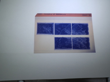
microfiche sheet, Victorian Land Tiltes Office, Township of Beechworth
Town layout of Beechworth5 Aperture Sized microfilms on a single microfiche in a paper sleeve plan, town, boundries, lots, roads -
 Rutherglen Historical Society
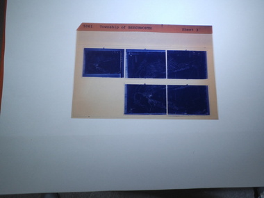
microfiche sheet, Victorian Land Tiltes Office, Township of Beechworth
Town layout of Beechworth5 Aperture Sized microfilms on a single microfiche in a paper sleeve plan, town, boundries, lots, roads -
 Rutherglen Historical Society
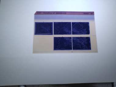
microfiche sheet, Victorian Land Tiltes Office, Township of Beechworth
Town layout of Beechworth5 Aperture Sized microfilms on a single microfiche in a paper sleeve plan, town, boundries, lots, roads -
 Ballarat Heritage Services
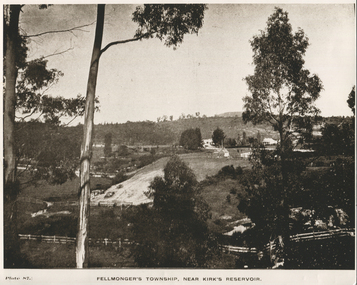
Photograph - Black and White, Fellmonger's Township
fellmongers -
 Ballarat Heritage Services
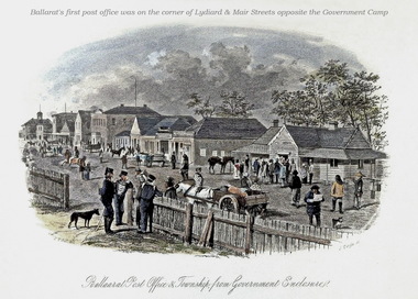
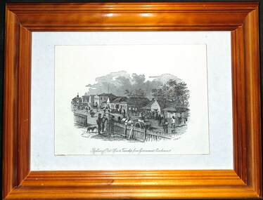
Image, Ballarat Post Office and Township from Government Enclosure
Coloured engraving by Samuel Thomas Gill showing the Ballaarat Post Office in the Government Camp. ballarat post office, government camp, camp st, ballarat, samuel thomas gill, s.t. gill -
 Inverloch Historical Society
0004425 Photograph - circa 1890 - Inverloch Township - WH Ferguson (Photographer) - State Library of Victoria
-
 Ballarat Tramway Museum
Decorative object - Framed, Samuel Thomas Gill, "Ballarat Post Office & Township from Government Enclosure", 1857
Ballarat's first post office was located in Ballarat East. The print is by S. t. Gill and depicts a busy street scene.Framed drawing - wooden frame with card backing and framing clips and foldout stand.ballarat, post office, gold fields, ballarat east -
 Stawell Historical Society Inc
Photograph, Panorama of Stawell Township with Poppet heads & Government Dam, later No2 Reservoir at centre of photo1878
Poppet heads and Government Dam later No2 Reservoir at centre of photo with Black Ranges in background. Stawell East State School on left, Wimmera Battery (also known as Cobb's Battery) on right of photo. 1878. Mr Chaponnel was an Engine Driver on the Battery. No2 West Scotchmans mine on left started in 1873No2 Reservoir in centre of photograph behind two prominent poppet heads. Black Range in right rear of photo. Victorian Views. C. Herbert, Photo. Stawell. 1878stawell mining -
 Federation University Art Collection
Watercolour, Neville Bunning, [Township]
This item is part of the Federation University Art Collection. The Art Collection features over 1000 works and was listed as a 'Ballarat Treasure' in 2007.art, artwork -
 Bacchus Marsh & District Historical Society
Map, Bacchus Marsh Township and Nearby Districts Maps Volume
This volume of maps is believed to have been compiled by staff at the Shire of Bacchus Marsh and was presumably used to inform and assist Shire staff and Councillors in the carriage of their duties.This collection of maps are significant due to their rarity as many of them are unique maps made for local purposes in the Bacchus Marsh region. They are also of strong research value containing a wide variety of information including landholders, land sales, infrastructure, such as roads, bridges, public, commercial and private buildings, houses, land use, and geographic features over multiple decades from the late nineteen century into the middle part of the twentieth century.One bound volume of maps comprising cadastral maps, (indicating property owners and land boundaries), land plans and real estate auction plans and advertising material, and other maps indicating major infrastructure like proposed roads and irrigation areas. Most of the maps and plans are of Bacchus Marsh and nearby areas but some maps are of nearby towns such as Melton, Ballan and Blackwood. The volume comprises 52 pages. Most pages have a single map or plan pasted onto it but some contain 2 or 3 different maps. There are 81 maps in total. Map 1 Liquidators Sale 1896. Map 2. Woodside Estate Sale 1913. maps, maps bacchus marsh, maps bacchus marsh region -
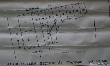 Melton City Libraries
Map, Block details section 21 Township of Melton, 1965
In 1861, Mary Dowling and John Luby obtained Crown Grant land on the corner of Smith and McKenzie Street Melton.Section 21 is covers the block of Smith, Henry and McKenzie Street Meltoncouncil -
 Wodonga & District Historical Society Inc
Photograph - Mitta Junction Township
Mitta Junction which was established about 1920 on the Victorian side of the Hume Dam construction site (originally called the Mitta Junction Reservoir). The town was built to house workers and their families. It included houses, private and government boarding houses, a shop, hall and school as well as tennis courts and a cricket pitch. Mitta Junction was a thriving community with many activities, including Balls and Euchre Nights, held at the Hall which opened in February 1922. The community also fielded a very successful football team in the local competition. After the completion of the Dam, the village and all its contents were sold at auction in June 1936 for £7,000. Individual houses sold at about £40 for removal to nearby towns. The Mitta Junction School which opened in 1922 continued to operate with very small numbers after the village was moved. Its numbers were boosted in the early 1980s by the children of Army staff at the nearby Latchford Barracks Army Apprenticeship School. It finally closed in December 1985.These images are significant because they capture the history of an important vanished town whose residents played a vital role in the construction of the Hume Dam.A collection of black and white images and a sketch map featuring the village of Mitta Junction, built to house workers on the construction of the Hume Dam. Some of the photographs have been mounted on heavy card.mitta junction township, hume dam construction, hume dam history -
 Buninyong Visitor Information Centre
Painting - Water colour painting, R. Anderson, Township of Buninyong near Ballarat, Victoria, Australia, 1988
Painted in 1988 during the Bicentennial year. Artist: R. AndersonWater colour showing south side of Learmonth Street, Buninyong, including Town Hall, Whykes' Butchers, a shop and the National Bank building.R. Anderson, '88 Copyright.buninyong, shops, streetscapes, learmonth street -
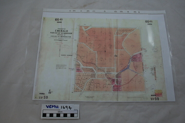 Emerald Museum & Nobelius Heritage Park
Map, Township of Emerald, Parish of Gembrook, counties of Evelyn and Mornington
Map showing property owners, posted 12 September 1956Includes Ferntree Gully to Gembrook Railway and Property Owners (coloured in pink). -
Merbein District Historical Society
Map, Township of Yelta, 30 Aug.1968
yelta -
Merbein District Historical Society
Map, Township of Yelta (Cowanna), 1958
yelta -
Merbein District Historical Society
Map, Township of Yelta, Jul.1968
yelta -
Merbein District Historical Society
Map, Township of Yelta, Jul.1968
yelta -
Merbein District Historical Society
Map, Township of Yelta (Cowanna), 1958
yelta -
Merbein District Historical Society
Map, Township of Yelta, 30 Aug.1968
yelta -
Merbein District Historical Society
Photograph, Merbein Township- Looking east towards Pumping Station, 1936
river avenue (taken from water tower), chaffey park tennis courts -
Merbein District Historical Society
Map, Township of Merbein - Sale of Allotments, 29 Jul.1914
-
Merbein District Historical Society
Photograph, Merbein township - looking along Main Ave, c.1950's
-
Merbein District Historical Society
Photograph, Merbein Township 2 - looking along Main Ave, c.1950's
-
 Linton and District Historical Society Inc
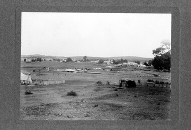
Photograph, Linton Township from Slaughterhouse Hill, circa 1920s, 1920
Slaughterhouse Hill was so named because Bennett's butchers had a slaughterhouse there.A view of Linton taken from Slaughterhouse Hill to the north-east of the town. Numerous buildings are identifiable in the photograph. In the middle foreground are the railway station, platform and station-master's house. The Grenville Standard building is visible in Clyde Street, and the Post Office and Bank of NSW buildings can be seen near the corner of Clyde and Sussex Streets. In the distance (along Sussex Street) the Royal Standard Hotel and the Shire Offices (original building) can be seen. St Paul's Church of England is on the far left of the photograph."Esther Cluff, Linton".linton township, slaughterhouse hill -
Lakes Entrance Historical Society
Book, Victorian Education Department, Ensay Township School State School No. 2953, 1889
Enrolment details of each student registered from 1889 to 1989. Includes parental detailsschools, occupation -
Linton and District Historical Society Inc
Certificate of Title, Certificate of Title : Crown Allotments 27, 28, 29, 30, Section 4, Township of Linton
The land was transferred to Theophilus William Nelson and James Adolphus Nelson in 1929. James and Theo Nelson later (1955) acquired Allotment 36, Section 4 which adjoins these allotmentsCopy of Certificate of Title for several adjacent blocks of land on the corner of Clyde Street and Grantley Street in Linton. Copy is comprised of photostat sheets held together by tape.theophilus william nelson, james adolphus nelson, certificates of title, allotments 27 - 30 township of linton -
Stawell Historical Society Inc
Map, Stawell Gold Mines, Stawell Township 1995, 1995
Map shows details of mining activity Stockpiles, Tracks, Plant, Dams,, Waste, Tailing Dams, IronbarksPlain Printed Map in Black & White with details of MiningStawell Gold Mines Pty Ltdmining -
Stawell Historical Society Inc
Map, Township of Stawell
B/W map of Stawell Surveyed by Easton Johnston Contract surveyor Scale in Chains. Showing Special Allotments Reefs, Pleasant Creek Parish of Stawell. Map No L4000 -
Stawell Historical Society Inc
Map, Plan View Township Area showing Known old workings 2003, 13 June 2003
Coloured Printing outline of lease of Gold Mine Horizontal Drives shown in BrownStawell Gold Mine. Scale 1:7500. Fri 13 June 2003mining