Showing 671 items
matching tunnelers
-
 Bendigo Historical Society Inc.
Postcard - Alice McGregor Postcard Collection, 1900 - 1920
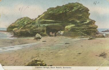
Alice McGREGOR Born: 1908; unknown parents. Possibly adopted by the Salter family? Electoral Roll 1936: Highland Terrace Kangaroo Flat. Alice Mary Salter and William Robert Salter living together; presumed to be sister and brother. William Robert Salter was killed in a MVA in Bendigo in 1937 aged 26. In Victoria in 1938, Alice Mary Salter married James Thomas McGregor (born Victoria 1917, died Victoria 1983, buried Fawkner Cemetery) Lived: 1968; 22 Wade Street Golden Square Alice McGregor Died: 1999 aged 91 at Anne Caudle Centre, Bendigo Buried: Kangaroo Flat Cemetery See additional research. Postcard Album of Alice McGregor contained 86 post cards.Postcard Album of Alice McGregor containing 86 postcards. See 1400 Colour photo of London Bridge, Back Beach, Sorrento, Victoria Rock structure at the water's edge. Tunnel through the rock showing several people emerging. (Same as postcard 1400.65) Addressed to Mr.M.J. Stapleton, Arcade, Bendigo Sender - A.S. Stamp dated Feb 19 1906 postcard, collector, alice mcgregor -
 Greensborough Historical Society
Newspaper Clipping, Diamond Valley Leader, 'Missing Link' unveiled, 12/09/2018
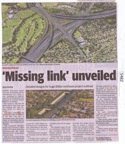
A twin three lane tunnel will start in Rosanna and go underground for 5.3km, it was confirmed in detailed plans for the North East Link released by Premier Daniel Andrews on Sunday.News article 1 page, black text and colour image .north east link, daniel andrews, rosanna -
 Melbourne Tram Museum
Pamphlet, Rail Projects Victoria, "MetroTunnel Newsletter", May. 2018
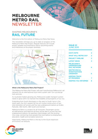
Pamphlet Series of 8 printed and digital documents - titled "MetroTunnel Newsletter issued by Rail Projects Victoria (formally Melbourne Metro Rail Authority). Reports on the changes to the Domain Intersection tram stops, track relocation during Easter 2018 and that the Tunnel boring machines are on the way. The machines are compared to the length and weight of E class trams. Includes station names Anzac Station. Has the logos of the State of Victoria and Rail Projects Victoria. Previous issues: down loaded from the Metro Tunnel website 22-10-2018 Issue 01 - June 2015 - i1.pdf 02 - December 2015 - i2.pdf 03 - May 2016 - i3.pdf 04 - May 2017 - i4.pdf 05 - October 2017 - i5.pdf 06 - May 2018 - i6.pdf - folded A3 sheet - Reports on the changes to the Domain Intersection tram stops, track relocation during Easter 2018 and that the Tunnel boring machines are on the way. The machines are compared to the length and weight of E class trams. Includes station names Anzac Station. 07 - October 2018 - i7.pdf - folded A3 sheets - reporting on work at Federation square and the station locations, some before and after photos and archaeological digs. 08 - September 2019 - i8.pdf - folded A3 sheet - report on traffic changes in Flinders St, the Tunnel boring machines, North Melbourne Station, progress at various sites. 09 - February 2021 - i0.pdf - folded A3 sheet, report on the tunnelling machine progress and a list of dates during 2020 along with notes on the Airport rail line.trams, tramways, metro tunnel, e class, domain interchange, domain junction, anzac station -
 Bendigo Military Museum
Award - MEDAL, CARD & IDENTITY DISC, 1 & .2) post 16.4.17, .3) post WW1
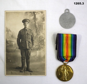
Thomas William Tuckerman enlisted on 16.4.17 in the Australian Tunnelling Coy reinforcements age 38 years. A Miner at 5 feet 2 and a half inches tall. Embarked for England 4.8.17, hospital on 1.11.17 with scabies, embark for France 14.11.17, transfer to 2nd Aust Tunneling Coy 28.7.18, WIA on 30.9.18 GSW to leg. Discharged from the AIF on 4.5.19. He was also entitled to the War medal 1914-19. Refer 935P for his other two brothers in the AIF..1 Sepia postcard, photo of T.W Tuckerman. .2 Grey coloured metal ID disc. .3 Victory Medal, gold coloured, rainbow ribbon.1 "Postcard photograph of Kia-ora Studio Seymour, Vic" .2 "7318 TW Tuckerman, Tunn. Coy. AIF C.E." .3 "7318 Spr T.W. Tuckerman 2 Tunn. Coy. AIF"medals, photography, identification -
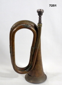 Bendigo Military Museum
Instrument - BUGLE
The Australian Army bugle is a brass musical instrument used primarily for Military Purposes including signaling, commands, ceremonies and other official functions. They are no longer used in battle but still used as part of tradition.Brown/gold coloured bugle. Small hook at top so as to be able to attach it. Mouthpiece comes loose and inserted into the air pipe. Bugle is in the form of a mouthpiece inserted into a simple hollow tube of metal that circles twice before coming out to form into a widening tunnel.Mouthpiece has "Vincent Back Corp - 2 3/4c" engraved.brass bugle, musical instrument -
 Federation University Historical Collection
Equipment - Scientific Instrument, T. Cooke & Sons Ltd, Theodolite, early 1900s
The theodolite is used in surveying and measures vertical and horizontal angles. Placed on a tripod, it is used to find angles in road building, tunnel alignment and other civil engineering work. The theodoliteTheodolite with four levelling screws. External focusing.ballarat school of mines, surveying, engineering, cooke, theodolite, scientific instrument -
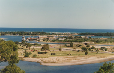 Lakes Entrance Historical Society
Photograph - Apex Park Lakes Entrance Victoria, M Holding, 1985 c
The town section of North Arm previously known as The Backwater Road Colour photograph taken from Kalimna Heights showing outer barrier and entrance channel. Road and new bridge to Bullock Island Apex Park beside North Arm in foreground has old playground equipment with timber fort and hillock with underground tunnel Lakes Entrance Victoria topography, waterways, parks, bullock island -
Tatura Irrigation & Wartime Camps Museum
Photograph, Dhurringile Escape
Copy of map made in Dhurringile POW Camp and carried by Captain Detmers during the tunnel escape by twenty German Officers and men. Map confiscated by the arresting officer at Tallygaroopna, Senior Constable Wilson.german officer pow's, dhurringile escape map, captain detmers, photograph, senior constable wilson -
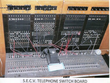 Kiewa Valley Historical Society
Photos: Kiewa Hydro Electric Scheme x 12
K.H.E.S.Photos 4 coloured and 8 black and white with the Title printed below each one. 1. S.E.C.V. Telephone Switch Board (See also KVHS 0847) 2.West Kiewa Tunnel 3. Construction of Underground Power Station 4. Pretty Vally Camp 5.Outside Kiewa House, Bogong 6. S.E.C.V. Saucer (See also KVHS 0128) 7.Insulator Disk Struck by Lightning 8. S.E.C.V. Map of the Kiewa Hydro Scheme 9.Howman's Gap Camp 10.Tunnel Excavation Face 11. Mt Beauty Townhship 1948, looking north east 12. Mt Beauty Township - no labelkiewa hydro electric scheme photos -
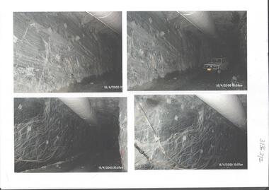 Bendigo Historical Society Inc.
Photograph - Kangaroo Flat Gold Mine Collection: underground in Swan Decline, Kangaroo Flat Gold Mine, 2000
The modern mine is accessed via the Swan Decline, which commences at the Kangaroo Flat site on the southern outskirts of Bendigo and progresses in a north easterly direction between the Deborah and Sheepshead anticlines, reaching a depth of almost 1000 m below the City of Bendigo. Development of this decline commenced in 1998. Swan Decline closed and history preserved In a major rehabilitation milestone at Kangaroo Flat, the Swan Decline Bendigo’s primary gateway to underground mining, was permanently closed in December 2022. Important parts of Bendigo’s gold rush history were also preserved from the onsite office buildings with 19 boxes of records, and 1350 old photos being scanned and provided to the local historical societies and the Goldfields Library Corporation. A volunteer from the Bendigo Historical Society, Kay MacGregor, also scanned approximately 40 bookshelves of newspaper clippings to assist with recording and preserving geological drilling locations.Black and white photocopies of photographs of Swan Decline, showing some stages of underground construction. Eleven images on 3 pages, dated 16/4/2000 (10 a.m.) show decline walls, rock bolts and markout of tunnel shape. One image shows a utility in the tunnel. Final three images on one page, have notations on the photos: 'opposite SP18 LHS decline', 'just up from previous 3 box positions' and 'just up from tank, same side' On bottom RH side 'spots for scale attention, IT required, all lower decline.' All three images dated 12/6/2000.goldmining, kangaroo flat gold mine, western mining corporation, unity mining, swan decline -
Stawell Historical Society Inc
Map, T.F. McGauran, William Couty of Borong 1891, 1891
Stawell Water Supply Reserve. Grampians State Forest. Dairy Creek, Fyans Creek, Barney's Creek, Bovine Creek, Glasstree Creek, Stoney Creek. Stawell Water Supply Aquaduct Fkuming Tunnel.A2 Parish Map of Willam Inculdin Stawell Water Supply Reserve and Creeks. Marked in redPhoto Lithographed at the Department of Lands and Survey Melbourne. By T.F. McGauran 20.07.91 water supply survey -
 Bendigo Historical Society Inc.
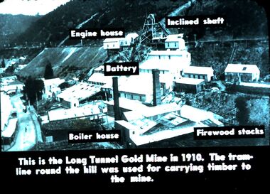
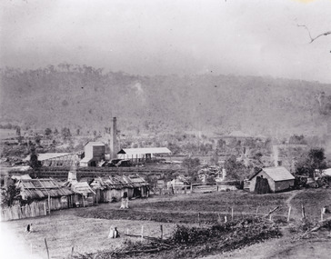
Slide - DIGGERS & MINING. DIGGERS AND MINERS, c1930s
Diggers & Mining. Diggers and miners. This is the Long Tunnel Gold Mine in 1910. The tram-line roamed the hill was used for carrying timber to the mine. Engine House, Inclined Shaft, Battery, Boiler House and Firewood stacks are marked on the slide. Markings: 30 994.5 WAL. Used as a teaching aid.hanimounteducation, tertiary, goldfields -
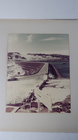
 Bendigo Historical Society Inc.
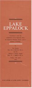
Document - LAKE EPPALOCK - OPENING CEREMONY PROGRAM
Folded document, 5 pages, produced to commemorate the opening of the Eppalock Dam, the Eppalock Pumping Station and the pipeline to Bendigo, by the Premier, Mr. H. Bolte, on 17th April, 1964. Brown cover, cream and black text. Illustrations show the cross section of the tunnel; a plan of the embankments and an overall plan of the weir.bendigo, waterworks, lake eppalock -
 Falls Creek Historical Society
Photograph - Gabillot and Dunn Children at Bogong
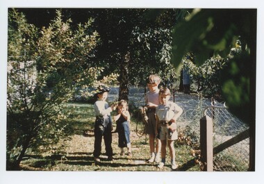
MEYER COLLECTION - FALLS CREEK PHOTOS In 1947 a determined group of like-minded State Electricity Commission (SEC) staff including Ray Meyer, the chief surveyor of the Kiewa Hydro-Electric Scheme, had a common interest that revolved around the skiing potential of the snow-covered high plains which included what is now the resort of Falls Creek. The six SEC employees, Toni St Elmo, Ray Meyer, Jack Minogue, Lloyd Dunn, Adrian Ruffenacht and Dave Gibson (together with their families) banded together to secretly build a 'hut' that was the first ski lodge at Falls Creek. Using a road built in 1930s to gain access to Falls Creek, their hut project was carried out in secret as efforts by other skiers were blocked by H.H.C. Williams – the engineer in charge of the Hydro Scheme. In 1946 Ray Meyer made a trip to the Lands Office in Melbourne. He came away with a 99-year lease on three acres that was ideally suited for a hut designed by Lloyd Dunn. Adrian Ruffenacht (Design Engineer for the KHS) had suggested where the group should build because of easy access to a spring for water. Much of the building material required was scavenged from derelict huts on the high plains. Due to the need for secrecy, the determined group worked on the hut in the evenings and weekends to avoid detection. During the building period the group had met at Echidna Rock (now known as Eagle Rock) where Skippy St Elmo announced, "This is my favourite ‘Skyline’.” And so the first lodge in the area at Falls Creek Ski Resort came into existence. With the development of the International Poma in the 1970s, the Skyline Lodge, which was sited between the ski-lift’s pole one and pole two, was demolished. However, the legacy of Ray Meyer, Toni St Elmo, Jack Minogue, Lloyd Dunn, Adrian Ruffenacht and Dave Gibson and Skyline lives on in the vibrant atmosphere of Falls Creek Resort. The MEYER COLLECTION documents developments on the Kiewa Hydro Scheme and their life at Falls Creek from the mid 1930s to 1960s.These images are significant because they depict aspects of the life of a pioneering family of Falls Creek and the founders of "Skyline", the first lodge at Falls Creek.A coloured image of children at Bogong. L-R:- Jean-Claude Gabillot, Didier Gabillot, Colin and Robin Dunn. The Gabillot Brothers were children of Phil Gabillot of "Trois Es', the French tunnel construction company, and Colin and Robin were the children of Lloyd Dunn, one of the founders of Skyline Lodge.falls creek, jean-claude gabillot, phil gabillot, john meyer, lloyd dunn -
 Eltham District Historical Society Inc
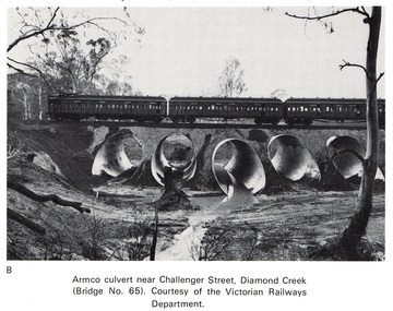
Work on paper (Sub-Item) - Photograph, Armco culvert near Challenger Street, Diamond Creek
Black and white photograph. A passenger train crosses Victorian Railways Bridge No 65 near Challenger Street, Diamond Creek. A series of steel culverts or tunnels carrying a stream have been constructed beneath the railway bridge.bridge, culvert, train, challenger street -
 Bendigo Historical Society Inc.
Document - VICTORIA HILL - NOTES ON SIGNS FOR VICTORIA HILL
Three page typed copy of notes for signs on Victoria Hill. Mentions items to be seen at Victoria Hill. Sign posts listed are for: Ballerstedt's First open Cut, Quartz Veins (Spurs), Prospecting Shafts 1929, Engine beds for Lansell's big 180 Mine, 20 Head Crushing Battery Stampers, concrete dam, Victoria Quartz Mine, Foundations of steel poppet legs of the Victoria Quartz Mine, Victoria Quartz Dams, Rae's Open Cut, Site where the quartz was roasted, Anticlinal Arch , coloured rock formations, primitive tunnels, Adit, Engine bed for Great Central Victoria, Prospecting Tunnels, Great Central Victoria (Midway). Notes prepared by Albert Richardson.document, victoria hill, notes on signs for victoria hill, gold mines hotel, ballerstedt's first open cut, quartz veins (spurs), prospecting shafts 1929, engine beds for lansell's big 180 mine, 20 head crushing battery stampers, concrete dam, victoria quartz mine, foundations of steel poppet legs of the victoria quartz mine, victoria quartz dams, rae's open cut, site where the quartz was roasted, anticlinal arch , coloured rock formations, primitive tunnels, adit, engine bed for great central victoria, prospecting tunnels, great central victoria (midway), a richardson -
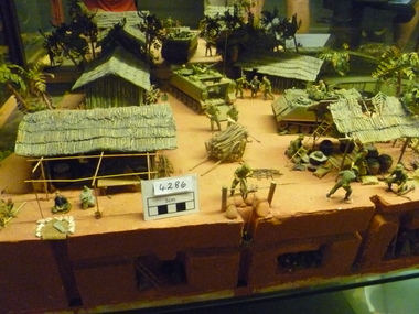 National Vietnam Veterans Museum (NVVM)
Model - Diorama, Cordon and Search
Diorama depicts a village with the huts / houses one covered storage area, two APC'S, Barrow with wood, pig pen,tunnels by three, boat on waterway and soldiers (searching for VC) Scenery includes trees and vegetation, wood piles and house hold items.C1967 Diorama is in two pieces joined by landing bridge.diorama -
Federation University Historical Collection
Document, Specifications for Building a Stone Wall and Making a Brock Tunnel for the Council of the School of Mines Ballarat, 1898, 1898
Four handwritten foolscap pages. The wall was to be built on the Eastern side of the ground facing Albert Street. The stonewall to be 73 feet long and eight feet six inches high. A curved tunnel formed to be about 50 feet long. The work was undertaken by Johnson brothers for one hundred and fifteen pounds five shilllings.ballarat school of mines, stone wall, tunnel, albert street -
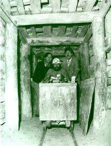 Federation University Historical Collection
Photograph - Black and White, 1988, Three men standing behind a trolley in a mine tunnel, 06/1988
This image was taken at the conclusion of a special eight week "Crash course" in mining, requested by Eastern Reefs. It was used in the Ballarat School of Mines Review, 1988, page 7.Black and white image of three men standing behind a trolley in a mine tunnel showing supporting beams (thought to be Sovereign Hill) They are from left to right Ernie Terrill (Ballarat CES), Raymond Collins (Ballarat School of Mines Mining Student) and Malcolm Vallance (Ballarat School of Mines Special Projects Manager).ballarat school of mines, mines, mining, mining trolley, mine truck, mining railway, malcolm vallance, mal vallance, raymond collins, ernie terrill, eastern reefs, sovereign hill, mining education -
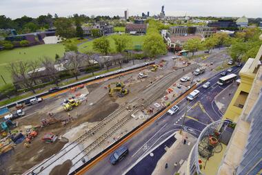 Melbourne Tram Museum
Photograph - Digital Image, Public Transport Victoria (PTV), "St Kilda Road and High Street - Buses replace trams - Sunday 13 Oct. to Sunday 27 Oct.", Oct. 2019
.1 - Pamphlet - 2 x 3 fold x titled "St Kilda Road and High Street - Buses replace trams - Sunday 13 Oct. to Sunday 27 Oct." 2019 for works at Domain, Park and St Kilda Road and track relay in High Street between St Kilda Road and Williams Road. Gives alternative bus routes. Part of the work was for the construction of the Noise Box or acoustic shed over the future Anzac Station site - part of the Metro Tunnel Works and track relocation. See htd3930i2.pdf for a detailed description of the work from the Metro Tunnel authority - Rail Projects Vic. This file does not want to open properly using dbtext works, access directly. Image i3 - from tdu website https://tdu.to/m/262235/re-d2-5005-at-temporary-tram-termin-us-st-kilda-road, shows the works underway. Posted by Metro Tunnel on twitter today showing progress on relocating tram tracks at site of Anzac station. This will allow construction of the southern box of the station. Large file (~2.6MB and 4096x2733 pixels, but enables you to get "up close and personal".trams, tramways, park st, domain junction, metro tunnel, toorak rd, st kilda rd, tramway construction -
 Kiewa Valley Historical Society
Leaflet - Kiewa, Welcome to Kiewa
The State Electricity Commission of Victoria constructed the Kiewa Hydro Electric Scheme from 1938 to 1961. The Scheme included three power stations, dams, tunnels and was becoming a popular tourist destination with Falls Creek Ski field within its boundaries.This leaflet was published by the SECV to ensure all visitors to the Kiewa Hydro Electric Scheme were made aware of safety measures with regard to their driving and to bush fires. These were necessary as the area was unique with driving on mountainous roads, changeable and extreme weather and the threat of bush fires. The gatehouse existed during construction, when the SECV was in charge, as a restriction to entry to the Scheme for SECV workers and those with permission to enter. The SECV controlled the area so in case of accident, the SECV was the body to contact not eg. the police.Small white and green leaflet made from one sheet of glossy paper and folded in half. Front cover has the title in the middle, the SECV emblem at the centre top and across the bottom is a message to read the inside pages which are safety messages for driving and bush fires. The back cover has a RACV road map of Kiewa and its 'works' including the Gatehouse which was the entrance to the scheme.The map also has an insert of the main roads & nearby cities. state electricity commission of victoria; kiewa hydro electric scheme; gatehouse; safety rules; kiewa -
Tatura Irrigation & Wartime Camps Museum
Document, Probably early 1940's
Detailing some of the ingenious methods of escape and the camouflaging of tunnelling. In January 1945, 20 officers escaped from Dhurringile and Lt Edgardo Simone , the Italian P.O,W was the outstanding escapee in Australia. Others are noted in Barbara Winter's book "Stalag Australia"Clear plastic folder, red margin on which is a white strip of paper. A red back cover. On the top right hand corner on the front clear plastic is a white self adhesive label on which is printed " Security of Prisoners of war and Internees - and escapes - Australian War Museum Archives - Canberra.As noted aboveaustralian war museum archives -
 The Beechworth Burke Museum
Photograph - Photograph - Reproduction
The photograph is a reproduction of a postcard from the Rocky Mountain Mining Company. In 1875, the Rocky Mountain Extended Gold Sluicing Company Ltd was created, utilising the previous Rocky Mountain claim for the area near Lake Sambell. The company employed A.L Martin to survey an area for a tunnel underneath Beechworth and Johnson Stephens to dig it. The tunnel was built at a rate of 40 feet a month and eventually measured 800 metres. The tunnel was a true accomplishment both in the present and during the 19th century. It was considered to be a marvelous engineering feat. Beechworth is renowned for its hydraulic sluice method of mining. This involved soil being exposed to torrents of water from high-pressure hoses. From 1876 until its closure in 1921, the mine produced an astounding 47,926 ozs of gold. Companies like this were the source of income for many Chinese gold-diggers who sought to make their fortune on the goldfields of Beechworth. During the height of the rush, the town had around 7,000 Chinese inhabitants living on the outskirts of town as they were not permitted to live within Beechworth itself.This image of the Rocky Mountain mine is historically significant as the mining complex is now non-existent, with the only remains being the tunnel built in 1880 by the company, which was considered one of the greatest engineering feats of the time. The image also provides a first-hand look into the social and cultural networks at play during the 19th century with racial segregation of the Chinese at the 'Chinese Camp', as well as an insight into Beechworth's origins during the Gold Rush.Black and white rectangular reproduced photograph printed on paperbeechworth, rocky mountain mine, sluicing, gold rush, mining, gold -
 Federation University Historical Collection
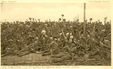
Postcard - Sepia, The "Fighting Fifth" after the Battle of St Eloi, c1916
Holmes Family WW1 memorabilia. 06 Apr 1916 - The Battle of St Eloi Craters, Canadian Expeditionary Forces Major Operation. “… the British had been patiently tunnelling since August (1915) at nearby St Eloi, about three miles south of Ypres, and adjacent to the Canadian trenches. Throughout the winter, the tunnelling crept ever closer to a dominant German-held feature dubbed “The Mound.” When the tunnels were completed in early March, tons of explosives were emplaced in six locations and on March 27, 1916, at 4:14 a.m. the charges were set off. Two German companies were wiped out and large sections of the German trenches were destroyed, but the British 9th Brigade’s attack faltered and became a bloody close-quarters slugging match, with the last bomb crater captured only on April 3.” (Zuehlke, Mark. Daniel, C. Stuart. The Canadian Military Atlas. The Nation’s Battlefields from the French and Indian Wars to Kosovo. Stoddart Publishing Co. Limited. Toronto. 2001 p. 125)A number of World War One soldiers, members of the Northumberland Fusiliers celebrate after the battle of St Eloi. Some or wear tin helmuts.The "Fighting Fifth" (Northumberland Fusiliers) after the battle of St Eloi"chatham-holmes family collection, fighting fifth, northumberland fusiliers, tunneling, explosion, crater, world war one, postcard -
Bendigo Historical Society Inc.
Document - MINING REPORTS - THE VIRGINIA MINE, A NEW EXIT
Handwritten notes on a new exit for the underground workers at the Virginia Mine. When the underground men leave the shaft after their shift, they will walk about 10 feet into a tunnel and then come up through the floor of the changing house by way of a broad staircase. Management claimed they would be protected in cold weather from the sudden change in temperature.document, gold, mining reports, mining reports, the virginia mine a new exit, bendigo advertiser feb 5th 1908 page 2, mr j hooper -
 Bendigo Historical Society Inc.
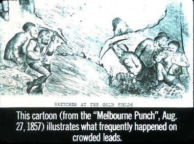
Slide - DIGGERS & MINING. GETTING THE GOLD, c1857
Diggers & Mining. Getting the Gold. Slide: Sketches at the Gold Fields. This cartoon (from the Melbourne Punch, Aug, 27, 1857) illustrates what frequently happened on crowded leads. Depicts miners digging their tunnels only to end up digging into the next lead. Markings: 27 994.LIF:4. Used as a teaching aid.hanimounteducation, tertiary, goldfields -
 Bendigo Historical Society Inc.
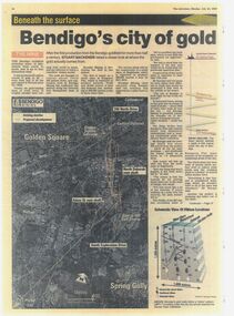
Newspaper - Bendigo's City of Gold is unearthed
Laminated copy of two page newspaper article. Bendigo Advertiser Monday 24 July 2006."Bendigo's City of Gold is unearthed", article about the revival of production of gold from the Bendigo Goldfields. Plans include cross section through the mines/goldfield covering the New Chum, Sheepshead, Deborah and Garden Gully tunnelling. gold production in bendigo, kangaroo flat decline, aerial photo, revival -
 Bendigo Historical Society Inc.
Photograph - Historical Society Field Trip to Coliban Water Assets, Dec 2009
The original Coliban Water Works were designed in 1863 by the Irish engineer Joseph Brady. The system included 70 kilometres of open water channels, aqueducts, syphons and tunnels to carry water (by gravity) from the Coliban River at Malmsbury, north to Castlemaine and Bendigo.One hundred and nineteen photos taken on a field trip by the Bendigo Historical Society to Coliban Water Supply assets.history, bendigo, coliban water, joseph brady, irrigation -
 Kiewa Valley Historical Society
Photo - Rocky Valley Dam
The State Electricity Commission of Victoria constructed the Kiewa Hydro Electric Scheme on the Bogong High Plains. The scheme consisted of storage dams and pondages, aqueducts, tunnels, pipelines, transmission lines and three power stations.. Rocky Valley dam was the biggest storage and the last to be completed.Rocky Valley dam was the largest storage within the Kiewa Hydro Electric Scheme. Begun in 1954 and completed in 1960. It was linked to McKay Creek Power StationColoured photo attached to cream cardboard. The background shows hills and the foreground a sign "Rocky Valley Dam ..." The middle shows the dam with water and its bank. There is snow on the ground.rocky valley dam, kiewa hydro electric scheme, secv -
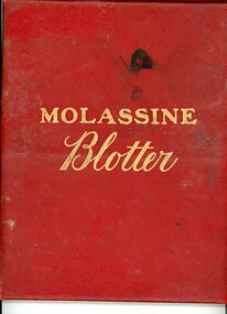 Bendigo Historical Society Inc.
Book - Molassine Blotter, 1910
Molassine was created in 1900 to exploit a secret formula for animal fed. The formula had been brought to Britain by Arthur Stein ‘a mid European probably hailing from one of the Balkan States’. At first the feed was made up by Henry Tate but in 1908 they began work in Greenwich. The molasses was bought locally from Silvertown and Plaistow refineries and the company built the first steel tanks for molasses bought from Danks, Steam Boiler Manufacturers, between 1910-1914. Their main product was a molasses based feed for horses - this consisted of sphagnum moss mixed with both beet and cane molasses and a ‘soupcon of maganesium calcum carbonate’. In the First World War this feed was considered antiseptic and soldiers used it as a plaster for wounds.Molassine Blotter Book published by the Molassine Company Limited, Tunnel Avenue, East greenwich, London, S.E. Red covered, it contains information Calendar for three years and information on domestic animals - how to keep them when ill, also an English Dictionary, Atlas, ready reckoner, address book, at home days diary etc.history, james lerk collection, molassine blotter