Showing 2412 items
matching update
-
 Falls Creek Historical Society
Document - Circular - Up-To-Date Committee News
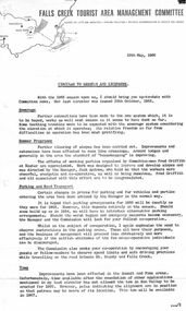
Bob (Herman) Hymans (a former member of the Royal Netherlands Navy) was born in Bloemendaal, Holland on 30th September 1922. During World War II he fought against the Japanese in the Dutch East Indies (now Indonesia) and was imprisoned in Changi and on the Burma Railway. After gaining qualifications as a Ski Instructor, Bob arrived in Falls Creek in July 1950. Working as an Instructor and Supervisor at Bogong Lodge, Bob decided his future was in accommodation. He was successful in negotiating an indenture for land from the State Electricity Commission (SEC). It took Bob two years to build his Grand Coeur Chalet but, tragically, it was burned down in August 1961. Bob also built the first Chairlift in Australia. This was a single chairlift and the structure was built from wooden electricity poles. He was constantly full of new ideas and proposals for the village. Bob Hymans died on 7th July 2007. This Collection of documents and letters tells the story of Bob's endeavours to develop Falls Creek into the ski village it is today.This item is significant because it documents actions taken by the Falls Creek Tourist Area Management Committee in their role overseeing the Tourist Area.A circular updating news prior to 1966 snow season. It includes information related to sewerage, Summer programme, parking and road transport, tows, snow conditions, Medical service, visiting skiers and the possible site for a ski jump. Other topics included Ski School, new buildings, behaviour, village entry and publicity.falls creek tourist area management committee, falls creek administration, preparations for winter season -
 Eltham District Historical Society Inc
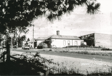
Photograph, Tom Prior, Doney's Store, Research
A much updated version of the store and house just prior to its removal.The Reynolds family were early settlers in Research. The Reynolds/ Prior collection of photographs were taken by Tom Prior, the maternal uncle of Ivy Reynolds, around 1900 and the 60 photos in the album give a fine overview of many of the landmarks of Research and Eltham over 100 years ago. lvy lived in the family home for many years at 106 Thompson Cres Research. Ivy's father, Ernst Richard Reynolds and grandfather, Richard Reynolds, lived at the same address. Ivy's father Richard worked for Mr. Trail on his property in Research. Reynolds Road is named after the family. Mr Tom Prior (wife Eva) worked at the Melbourne zoo. He was very innovative and made his own camera, using the black cloth hood to exclude the light. The photographs are a reminder of the rural nature of Research and Eltham and its rich heritage. Black and white photograph mounted in an album, the Reynolds/Prior Photograph Collection, this being one of 53 reproduced black and white images of early Eltham.The Reynolds/Prior Photograph Collection, Presented to the Eltham District Historical Society, 14 June 2006 by Ross McDonald. A second copy was also presented to the Andrew Ross Museum, Kangaroo Grounddoney property, eltham south, general store, ingrams road, main road, research (vic.), reynolds prior collection, shops, state route 44 -
 Port Melbourne Historical & Preservation Society
Photograph - Port Melbourne light rail terminus, 2002
Further updates from Ron Laing's photograph collection of Port Melbourne.(4) colour photographs of the Port Melbourne tram terminus showing its location in relation to the old Port Melbourne railway station, now a medical centre.transport - tramways, ron laing -
Port Melbourne Historical & Preservation Society
Photograph - Olive's Corner dedication ceremony by Cr Julian HILL, Port Melbourne, 2 Mar 2002
Further updates from Ron Laing's photograph collection of Port Melbourne.(8) photographs of the Olive's Corner Dedication ceremony and unveiled by councillor Julian HILL on March 2002.memorials, built environment - civic, celebrations fetes and exhibitions, parks and gardens, ron laing, olive's corner, olive zakharov, julian hill -
Port Melbourne Historical & Preservation Society
Photograph - Waiting room, Station Pier, 2002
Further updates from Ron Laing's photograph collection of Port Melbourne.Two views of waiting room for paddle steamer, western side of Station Pier, 2002piers and wharves - station pier, transport - ferries, ron laing -
Port Melbourne Historical & Preservation Society
Photograph - Dedication of Centenary Bridge pylon by Cr Julian HILL, 8 Feb 2002
Further updates from Ron LAING's photographic collection of Port Melbourne(9) colour photographs of the ceremony dedicating the Plaque to the Centenary Bridge Pylon by Councillor Julian HILL Fri 8th Feb 2002memorials, built environment - civic, celebrations fetes and exhibitions, julian hill, ron laing, centenary bridge -
Port Melbourne Historical & Preservation Society
Pamphlet - Beach to Borough: Liardet's Beach and Early Sandridge 2016, Pat Grainger, Walks around Vintage Port No.1, Jun 2016
Update and reprint of Walks Around Vintage Port No 1. Supported by CoPP.Port Melbourne Historical and Preservation Society publication, "Walks around Vintage Port", No.1 Beach to Borough: Liardet's Beach and Early Sandridge, 2016 edition. built environment, wfe liardet, wilbraham frederick evelyn liardet -
Port Melbourne Historical & Preservation Society
Pamphlet - Along the Vanishing Lagoon 2016, Pat Grainger, Walks around Vintage Port No.2, Jun 2016
Update and reprint of Walks Around Vintage Port No 2. Supported by CoPP.Port Melbourne Historical and Preservation Society publication, "Walks around Vintage Port", No.2 Along the Vanishing Lagoon, 2016 edition. sandridge lagoon -
Port Melbourne Historical & Preservation Society
Pamphlet - Steamer and Streamers: The Piers at Port Melbourne 2016, Pat Grainger, Walks around Vintage Port No.3, Jun 2016
Update and reprint of Walks Around Vintage Port No 3. Supported by CoPP.Port Melbourne Historical and Preservation Society publication, "Walks around Vintage Port", No.3 Steamer and Steamers - The Piers at Port Melbourne 2016 Editionpiers and wharves - princes pier, piers and wharves - station pier, built environment -
Port Melbourne Historical & Preservation Society
Pamphlet - From Pier to Fountain: Browsing Bay Street 2016, Pat Grainger, Walks around Vintage Port No.4, Jun 2016
Update and reprint of Walks Around Vintage Port No 4. Supported by CoPP.Port Melbourne Historical and Preservation Society publication, "Walks around Vintage Port", No.4 From Pier to Fountain: Browsing Bay Street 2016 Editionbay street, built environment -
Port Melbourne Historical & Preservation Society
Pamphlet - Historic Housing Schemes of Garden City 2016, Pat Grainger, Walks around Vintage Port No.5, Jun 2016
Update and reprint of Walks Around Vintage Port No 5. Supported by CoPP.Port Melbourne Historical and Preservation Society publication, "Walks around Vintage Port", No.5 Historic Housing Schemes of Garden City 2016 Editiongarden city, built environment, architecture, city engineers, g b leith, fred cook -
 Stawell Historical Society Inc
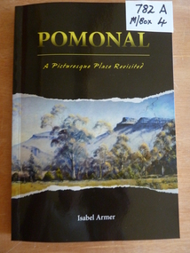
Book, Isabel Armer, Pomonal – A Picturesque Place Revisited, 2013
A Updated version, launched at Pomonal, by Pomoanl Progress Association Feb 2023 Black Card cover with a picture of mountains behind a line of trees.Pomonal A Picturesque Place Revisited Isabel Armer Authors Signature inside.stawell, family history -
 Ballarat Tramway Museum
Negative, Geoff Grant, 6/07/1954 12:00:00 AM
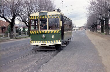
Negative No. 280 and colour print made by colour laser printer (stored in folder ) of W2 496 in bound along St. Kilda road, outside Victoria Barracks, 6/7/1954. Tram has destination of "CITY". Photo by Geoff Grant. Hi res scan of negative and image updated 19/5/2020.trams, tramways, melbourne, st kilda road, victoria barracks, tram 496 -
 Ballarat Tramway Museum
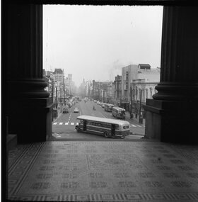
Photograph - Black & White Photograph/s, Geoff Grant, 16/06/1955 12:00:00 AM
View of Bourke Street Melbourne from just inside pillars of Parliament House looking west on 16 June 1955, a few days before the trams took over. MMTB Bus 580 turning into Bourke St from Spring St. Negative scanned hi res and imaged updated 20/5/2020.On rear in typed on paper "Buses inn Bourke St. A shot taken a few days before the trams took over. Taken from Parliament House steps 16 June 1955." & "Geoff Grant etc." stamp in btm rh corner.trams, tramways, melbourne, bourke st -
 Ballarat Tramway Museum
Negative, Travis Jeffrey, 17/06/1962 12:00:00 AM
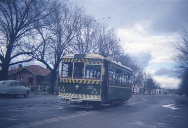
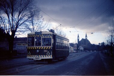
Colour Negative No. N396, of Bendigo Birney No. 30 on the North Bendigo line at the Bridge St. loop. Tram has the destination of Golden Square. Photo possibly 17/6/1962. Colour laser printed copy of image stored in box 73. Image scanned at hi res 27/5/2020 and image updated.In red pen on folder that contained negative, "NR69B" and "17 Jun 62". trams, tramways, bendigo, bridge st, north bendigo, tram 30 -
 Ballarat Tramway Museum
Negative, Travis Jeffrey, 17/06/1962 12:00:00 AM
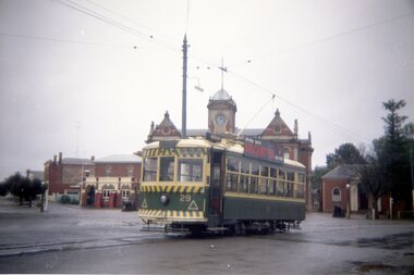
Colour Negative No. N397, of Bendigo Birney No. 29 at the Eaglehawk terminus, with the Eaglehawk Town Hall in the background. Tram has a Briquettes roof advertisement. Photo possibly 17/6/1962. Colour laser printed copy of image stored in box 73. Image scanned at hi res 27/5/2020 and image updated.In red pen on folder that contained negative, "NR68B" and "17 Jun 62". trams, tramways, bendigo, eaglehawk, tram 29 -
 Ballarat Tramway Museum
Negative, Travis Jeffrey, 17/06/1962 12:00:00 AM
Colour Negative No. N401, of Bendigo Birney No. 30 at Myrtle St loop on the Golden Square line. Tram has the destination of Golden Square. Photo possibly 17/6/1962. Colour laser printed copy of image stored in box 73. Image scanned at hi res 27/5/2020 and image updated.In red pen on folder that contained negative, "NR71B" and "17 Jun 62". trams, tramways, bendigo, golden square, myrtle st, tram 30 -
 Ballarat Tramway Museum
Negative, Travis Jeffrey, 5/08/1962 12:00:00 AM
Colour Negative No. N407, of the Bendigo No 11 on the North Bendigo line at the Bridge St. loop. Tram has the destination of Golden Square. Photo taken possibly on 5/8/1962. Colour laser printed copy of image stored in box 73. Original negative hires scan and image updated 28/5/2020.In red pen on folder that contained negative, "NR95B" and "5 Aug 62". trams, tramways, bendigo, north bendigo, bridge st, tram 11 -
 Melbourne Tram Museum
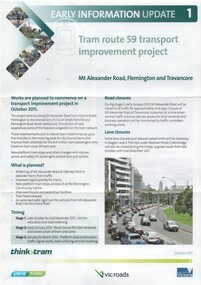
Pamphlet, VicRoads, "Tram route 59 transport improvement project", Oct. 2011
Pamphlet - 3 fold DL - titled "Tram route 59 transport improvement project", Early information update 1, detailing with a plan changes to Mount Alexander Road, Flemington and Travencore, Oct. 2011. Gives details of the staging, roadworks and timing. Has the Yarra Trams, VicRoads, Think Tram and Victorian Government logos.trams, tramways, mount alexander road, route 59, trackwork, road works -
 Ballan Shire Historical Society
Photograph - Photograph. L A Fairbairn, Lachlan Alexander Fairbairn, 1916
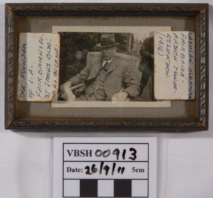
There is not much information on this item at the moment. The record will be updated when more becomes available.A small black and white photograph of L.A. Fairbairn sitting in a wicker chair outdoors. The photograph is under glass in a small timber frame with scrolled upper edges.Labels stuck on the glass read - " the founder of L.A. Fairbairn 7 Co. St. James Bldg Melbourne" and "Lachlan Alexander Fairbairn - Ardoch tower-Essendon (1916)". A sticker, D4, is on the back of the frame.fairbairn lachlan alexander, l a fairbairn co -
Port Melbourne Historical & Preservation Society
Photograph - Changing Port Melbourne, 2000 - 2001
Further update photographs from Ron Laing's collection of Port Melbourne locations(3) colour photographs of: .01: Bay and Graham Streets intersection, April 2001 .02: Beacon Rd and Howe Parade roundabout, Sept. 2000 .03: the new seafront promenade in Beacon Cove, 2000built environment - civic, bay street, graham street, beacon road, beacon cove -
Port Melbourne Historical & Preservation Society
Photograph - Webb Dock, Port Melbourne, 2000 - 2001
Further update photographs from Ron Laing's collection of Port Melbourne locations(3) colour photographs of Webb Dock west and beach front looking from Beacon Cove to Webb Dockpiers and wharves - webb dock -
Port Melbourne Historical & Preservation Society
Photograph - Various ships at Station Pier, 2002
Further updates from Ron Laing's collection of photographs covering Port MelbourneFive colour photographs of a French naval vessel (Nivose), a Japanese training ship (Taisei Maru) and the Greenpeace vessel (Arctic Sunrise), all of which have visited Station Pier during 2001/2002piers and wharves - station pier, transport - shipping, public action campaigns, fns nivose- french navy ship, tasei maru - japanese training ship, arctic sunrise - greenpeace ship -
Port Melbourne Historical & Preservation Society
Pamphlet - Beach to Borough: Liardet's Beach and Early Sandridge 2001, Pat Grainger, Walks around Vintage Port No.1, 2001
Update and reprint of Walks Around Vintage Port No 1. Project Assisted by CoPP.Port Melbourne Historical and Preservation Society publication, "Walks around Vintage Port", No.1 Beach to Borough: Liardet's Beach and Early Sandridge, 2001 edition. built environment, wfe liardet, wilbraham frederick evelyn liardet -
Port Melbourne Historical & Preservation Society
Pamphlet - Along the Vanishing Lagoon 2001, Pat Grainger, Walks around Vintage Port No.2, 2001
Update and reprint of Walks Around Vintage Port No 2. Project Assisted by CoPP.Port Melbourne Historical and Preservation Society publication, "Walks around Vintage Port", No.2 Along the Vanishing Lagoon, 2001 edition. sandridge lagoon -
Port Melbourne Historical & Preservation Society
Pamphlet - Historic Housing Schemes of Garden City 2001, Pat Grainger, Walks around Vintage Port No.5, 2001
Update and reprint of Walks Around Vintage Port No 5. Project Assisted by CoPP.Port Melbourne Historical and Preservation Society publication, "Walks around Vintage Port", No.5 Historic Housing Schemes of Garden City 2001 Editiongarden city, built environment, architecture, city engineers, g b leith, fred cook -
 Greensborough Historical Society
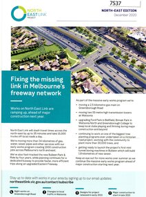
Pamphlet - Newsletter, Victorian Government, Fixing the missing link in Melbourne's freeway network, 2020_12
An update on the North East Link Project, the North-East Edition December 2020 Large sheet folded twice. Colour illus. and map. 2 copies.north east link, western ring road -
Port Melbourne Historical & Preservation Society
Pamphlet - The Pubs of Port 2012, Pat Grainger, Walks around Vintage Port No.6, Jun 2012
Update and reprint of Pubs of Port Walk. Supported by CoPP. The original Pubs in Port Walk was No 7 with No 6 reserved for Bend on the River: Westgate Park. The Westgate Park walk was not produced so the first updated version the Pub walk in 2001 became No 6 and this version (2012) maintained that numbering.Port Melbourne Historical and Preservation Society publication, "Walks around Vintage Port", "No.6 Pubs of Port" 2012 Edition.built environment - commercial, business and traders - hotels -
 Flagstaff Hill Maritime Museum and Village
Document - Navigation Chart, Admiralty Office, Lady Bay and Warrnambool Harbour, 1893
This navigation cart of Lady Bay and Warrnambool Harbour was originally surveyed in 1870 but this version includes the update for magnetic variation in 1893. Since the printing of the chart several annotations have been added. These include an additional stamp dated 15-8-1910, a handwritten comment across the top of the page dated August 1910, and another handwritten comment regarding the ‘Proposed Extension of Dock’ dated 19-2-1925, plus connected drawings, notes and figures. The 1925 proposal on this chart may have been a reaction to the Royal Commission of 1923, when the damaged stonework on the seaward side of the Warrnambool Breakwater, caused by the action of the sea, was the subject of enquiry. A conference between the Public Works, Water Commission and the Harbour Trust concluded that it would less costly to make repairs to prevent further damage rather than replaced the damage portion of the wall. A contract was raised in late 1924 to deposit rubble on the damaged side of the breakwater to minimise the Southern Ocean’s destructive action and work had started by August 1925. The Breakwater construction had begun in 1874 and was completed in 1890. The Victorian Government had commissioned Sir John Coode, a British harbour engineer, to present a plan to complete the Warrnambool Breakwater but his original plan was too expensive. He prepared a revised plan for a shorter structure. The construction proved to be too short to protect adequately from the weather and didn't allow enough depth for larger vessels to come into port. The decreasing trade was further affected by siltation in the bay due to the breakwater, and the completion of the railway line. The situation of the harbour became a real problem by 1910 and required continuous dredging. In 1914 the Breakwater was extended but proved to be a failure because the work began to subside and by 1920 about two thirds of the harbour was silted up. Alterations made in the 1920's increased the silting problem and by the 1940's the harbour was no longer used. More alterations were made in the 1950's and 1960's. This chart is significant for its strong connection to the maritime history of Warrnambool Harbour and Lady Bay and the Warrnambool Breakwater. The Warrnambool Breakwater is registered as a place of significance on the Victorian Heritage Database (VHR H2024). The Warrnambool Breakwater is one of the most important late 19th century maritime engineering projects in Victoria and significant in the development of Victorian coastal shipping. It is also significant for its connection with British harbour engineer, Sir John Coode. The chart is a historical record of structures existing in 1893; the Warrnambool Jetties, Warrnambool Breakwater in Lady Bay, the leading lights (lighthouses), streets, roads, bridges and many buildings. It also shows the lay of the land and seabed. Navigation Chart: Lady Bay and Warrnambool Harbour, Australia - South Coast - Victoria. Surveyed by Nav. Lieut. H.J. Stanley, R.N., 1870. Updated for Magnetic Variation, 1893. The rectangular chart is printed on heavy cream paper. Stamps are shaped rectangular, oval and round. Around the Breakwater and Jetty area are handwritten notes, dotted and joined lines, numbers and signatures, and shading of red and green. The chart shows the surrounds of Warrnambool Harbour, Lady Bay, the Breakwater and Jetty, roads, bridges and the streets in Warrnambool. It has sounding details, and angles of line from the leading lights.Stamp, rectangular, including "AUG 1910" Stamp, double oval " - - - -CHART" Stamp, hand drawn, red circle, with "B" inside Hand written note "22-8-1910 - - - - - of surveying C. Ca - - - request of 15-8-10 [initials] " Notes and lines in red pen, including a grid of sounding numbers: "1300" "1050" "1200" "Possible Extension of Dock" "19-2-25" "Dock Dredged to 20 Ft" Notes and lines in blue pen "Extension of Dock to accommodate vessels drawing 20 Feet" and "Light not visible south of this line" Red dots (4) with yellow highlight at both leading lights, breakwater and jettyflagstaff hill, warrnambool, flagstaff hill maritime museum & village, maritime museum, maritime village, shipwreck coast, map, chart, navigation chart, plan, lady bay, warrnambool harbour, port of warrnambool, breakwater, jetty, pier, dock extension, proposed extension, vhr h2024, 1870, 1893, 1910, 1925, warrnambool town late 1800s, warrnambool streets late 1800s royal commission, 1923, public works, water commission, harbour trust, victorian harbours, sir jon coode -
 Orbost & District Historical Society
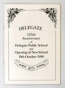
book, Delegate 125th Anniversary of Delegate Public School and Opening of New School 19th October 1996, 1996
This book was compiled for the 125th anniversary of Delegate Public School.This book is a useful reference tool on the history of Delegate.A paper covered book titled, "Delegate 125th Anniversary of Delegate Public School and opening of New School 19th October 1996". The cover is a cream colour with black print. There is a black border with decorated top corners. Inside the border is the title and a scroll with "Delegate 1871 School". It contains the history of Delegate and the public school and is an updating of the centenary booklet.delegate-history book