Showing 234 items matching "victoria crescent"
-
 Wodonga & District Historical Society Inc
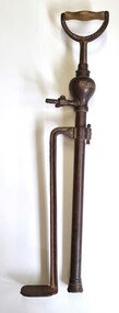
Functional object - Brass Stirrup Pump
A stirrup pump is a portable reciprocating water pump used to extinguish or control small fires. It is operated by hand. The operator places a foot on a stirrup-like bracket at the bottom of the pump to hold the pump steady. The bottom of the suction cylinder was placed inside a bucket of water. Water was drawn by pumping the handle up and down to create suction. The pumps were used in a variety of settings to enable quick action if a small fire broke out. They were a vital tool in London during the Blitz of World War 11. On the local level they were also used for spraying fruit trees, plants and vines. The Crescent Tool Company was founded in 1907. The Crescent brand has changed ownership multiple times. It is currently owned by Apex Tool Group but still also trades as Crescent in Australia. This pump was donated by Geoff Williams of Wodonga and was used at "Orange Vale" farm at Oxley Flats near Wangaratta. "Orange Vale" was owned by Mr. Robert Williams. Widely known as "Uncle Bob". in the 1940s Mr. Williams opened up the family property, established in the 1860s, as a camp for young people from Wangaratta. By 1951, this had extended to catering to group camps for children from Victoria, New South Wales and Queensland. 250 children could be accommodated at one time and as many as 3,000 children enjoyed the facilities each year.These pumps were important in fire fighting in a range of settings and were adapted for use in agricultural and small farm settings,A brass stirrup pump with wooden handle. It consists of 2 parallel brass pieces, one with a foot piece attached to keep the pump steady. The base of the pump is fitted with a pierced metal filter that prevents grit and debris being drawn into the pump and fouling it. 2 butterfly screws enable adjustment of height and securing a hose.crescent tools, orange vale, fire equipment -
 Pyrenees Shire Council
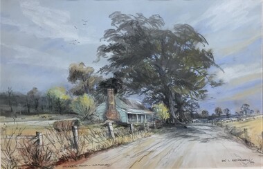
painting, Ian L Anderson, School Road, Waterloo by Ian L Anderson, 1995
significant as a work of art by local Pyrenees artist, locally significant to the Central Highlands Region of Victoria as a representation of local landscape and/or culture pastel drawing of a street scene with old house, trees and unpaved road"Signed: IAN L ANDERSON 95 (lower right) Titled: SCHOOL ROAD - WATERLOO (lower centre) Verso (affixed): ""SCHOOL ROAD - WATERLOO"" PASTEL AND CHARCOAL PENCIL PAINTING by IAN L. ANDERSON 14 MILLAR CRESCENT MT WAVERLEY 3145 signed: Ian Anderson '95 $500" -
 Lakes Entrance Historical Society
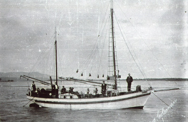
Photograph - Crescent, 1905 c
... in background. Nine men onboard. Mallacoota Victoria Photograph Crescent ...Note in album from Reg Schulz. Ketch 'Crescent' built at Eden NSW about 1905. After a long lay up she was bought by David Coote, Lakes Entrance, about 1925.Black and white photograph showing ketch Crescent at Mallacoota Inlet. Howe Range in background. Nine men onboard. Mallacoota VictoriaGeo. Coleman 1905fishing industry, ships and shipping, waterways -
 Ringwood and District Historical Society
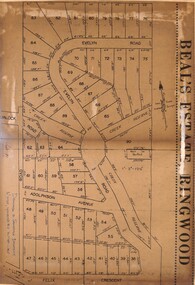
Document - Folder, Beale's Estate Subdivision, Ringwood, Victoria - circa 1960
Manilla folder containing two undated maps of Beale's Estate subdivision 20559 showing allotments on Evelyn Road, Burlock Road (later Burlock Avenue), Adolphson Avenue, and Felix Crescent, North Ringwood. -
 Ringwood and District Historical Society
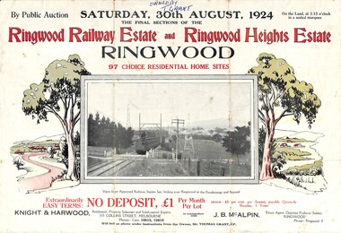
Flyer, Auction Sale Advertisement - Ringwood Railway Estate and Ringwood Heights Estate, Ringwood, Victoria - August, 1924
Refer also to Reg. No. 5183 for Ringwood Railway Estate (September 1923) and Reg. No. 5184 for Ringwood Heights Estate previous release (March 1924)Folded double-sided brochure advertising public auction of Final Sections of Ringwood Railway Estate and Ringwood Heights Estate on Saturday, 30 August, 1924, with town photographs, location map, terms of sale, and summary of local features and services.Subdivision includes Whitehorse Road, Sherbrooke Avenue, Burwood Avenue, Bon View Avenue, Grant Crescent, Hillcrest Avenue, Heatherbrae Avenue, Margaret Street, and Mary Street. (Agents) Knight & Harwood, 315 Collins Street, Melbourne, Phones Central 10615, 10616, in conjunction with J.B. McAlpin, Opposite Railway Station, Ringwood, Phone Ringwood 7. Footnote - "Will sell as above under instructions from the Owner, Mr. Thomas Grant, J.P.". -
 Surrey Hills Historical Society Collection
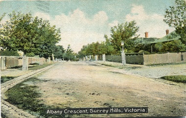
Postcard, Albany Crescent,Surrey Hills, Victoria Postcard
... Albany Crescent,Surrey Hills, Victoria Postcard...A coloured stamped postcard identified as Albany Crescent...SHP2213a Postcard front "Albany Crescent, Surrey Hills...Albany Crescent, Surrey Hills, Victoria, Australia... "Albany Crescent, Surrey Hills, Victoria". On the back ...We hold 2 copies of this post card, the image of which which had been hand-tinted. The tree guards along the street prevented horses from browsing on their bark and leaves. The street on the right is probably Beatrice Avenue. SLV collection dates the post card as c1906.A coloured stamped postcard identified as Albany Crescent, Surrey Hills, Victoria showing the tree plantings on the naturestrips, gutters and houses with picket fences.SHP2213a Postcard front "Albany Crescent, Surrey Hills, Victoria". On the back is a message addressed to Mr N Smith at Phillip Island from "Ada". SHP2213b Received 2001 See our postcard print also/ From Julie Jones Heritage Officer Whitehorse/ after Heritage Trails published/ Have an original card already.albany crescent, surrey hills, ada, mr n smith, phillip island, post cards, 1901-1910 -
 Ringwood and District Historical Society
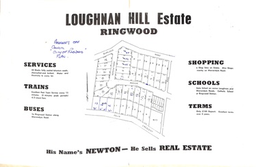
Document - Folder, Subdivision Map - Loughnan Hill Estate, Ringwood, Victoria - circa 1960
Open centre page of land sale brochure glued to manilla folder. Map of residential and shop sites in Burlock Road (later Burlock Avenue), Adolphson Avenue and Felix Crescent, Ringwood, with summary of estate facilities and local services. Agent - T.G. Newton.(Page glued to manilla folder prevents access to front page for further sale information) -
 Ringwood and District Historical Society
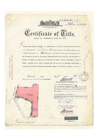
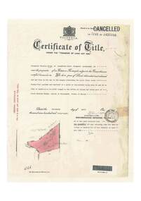
Document, Certificate of Title - Thomas Arthur Wentworth Burkitt - part of Crown Section 20, Parish of Warrandyte, County of Evelyn - 5th June, 1929
A4 copies of Landata Victoria Historical Search documents - Vol 5598 Fol 1119416.Thomas Arthur Wentworth Burkitt of Box Hill, Retired Clerk of Courts, is now the proprietor of an Estate in Fee-simple subject to the Encumbrances notified hereunder ... 35 acres 1 rood 11 perches or thereabouts, together with right of carriage way over part of Warrandyte Coach Road on plan of subdivision no.12040. Subdivision maps includes Brysons Road, Warrandyte Coach Road (later Wonga Road), Rangeview Parade (later Omeo Parade), and Kardinia Crescent, Warranwood. Mortgages and Transfers include Mortgate - part to the Trustees of Vic District no.82 I.O.O.R, 1st August, 1929, Mortgate - part to Arthur Edward Perry, 1st August, 1929, Transfer 1426692 - George Clements Dickason and Will Gordon Sprigg, 20th August, 1929, Transfer 1766662 - Linda Elizabeth Collins, 28th March, 1940. -
 City of Moorabbin Historical Society (Operating the Box Cottage Museum)
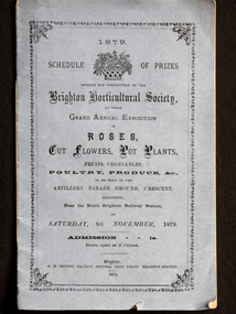
Booklet - Schedule Booklet, horticultural prizes, "1879 Schedule of Prizes Brighton Horticultural Society", 1879
This booklet from 1879 was given to the Moorabbin Historical Society when the Robert Keys Leader Cup Trophy, 1882-1883 was re-discovered at 'Box Cottage' Museum in 2009. The Leader Cup Trophy, MAV 00001, is also itemised in this booklet (p9) The Leader Newspaper offered the 'Silver Cup, value Five Guineas for the best fruit garden in the Brighton District. The Proprietors of the English, Scottish and Australian Chartered Bank offered an second prize of three Guineas Commencing in 1856, the Brighton Horticultural Society only disbanded in 2009, and most of their archival holdings were given to the Brighton Historical Society. This booklet gives a good idea of the large varieties of plants, poultry and the skills of the pioneer settlers of the Brighton District.This Booklet describes the Schedule of Prizes for the 1879 Grand Annual Exhibition of the Brighton Horticultural Society in Brighton Victoria. The Booklet was donated to the Moorabbin Historical Society in 2009 upon the disbanding of the Brighton Horticultural Society..at that time. The Moorabbin Historical Society possesses the 1882 'Leader Cup Trophy' (cat 00001) presented to Robert Keys for the best Fruit Garden. This booklet is kept in the same cabinet as the Robert Key's Silver Trophy. After Henry Dendy's Special Survey in 1841 allotments of land were sold or rented to pioneer settlers who developed market gardens , fruit gardens and poultry farms in the Brighton area. Their produce was sold at the St Kilda and Melbourne Markets for the growing population of MelbourneBooklet with mauve paper cover and 16 pages listing the Schedule of prizes for the 1879 annual exhibition of the Brighton Horticultural Society to be held in Brighton, Victoria."1879/ SCHEDULE OF PRIZES/OFFERED FOR COMPETITION BY THE/ BRIGHTON HORTICULTURAL SOCIETY,/ AT THEIR/ GRAND ANNUAL EXHIBITION/ OF / ROSES,/ CUT FLOWERS, POT PLANTS,/ FRUITS, VEGETABLES,/ POULTRY, PRODUCE, &c.,/TO BE HELD IN THE/ ARTILLERY PARADE GROUND, CRESCENT, / BRIGHTON,/ Near the North Brighton Railway Station, / ON / SATURDAY, 8th NOVEMBER, 1879./ ADMISSION 1s. / Doors open at 2 o'clock. / Brighton: / G. H. ORFORD, MACHINE PRINTER, NEXT NORTH BRIGHTON STATION. / 1879 ;melbourne, keys robert, trophy, leader newspaper, leader cup, brighton, silver, moorabbin, bentleigh, markets, dendy henry, st kilda, bent thomas, market gardens, brighton horticultural society, fruit gardens, banks chartered -
 Ringwood and District Historical Society
Document, Certificate of Title - Alexander William Brown - part of Crown Section 20, Parish of Warrandyte, County of Evelyn - 16th April, 1948
A4 copies of Landata Victoria Historical Search documents - Vol 7141 Fol 1428080.Alexander William Brown of Grandview Grove (later Bemboka Road), Ringwood is now the proprietor of an Estate in Fee-simple subject to the Encumbrances notified hereunder ... 2 acres 3 roods 24 and one-half perches or thereabouts, being Lots 33 and 34 Kardinia Crescent, on Plan of Subdivision no.12040. Transfers include Alexander William Brown died 25th June, 1957, Probate granted 28th January, 1958, to Alfred Hart Brown of Dandenong, Estate Agent, and Harry Britten Elms of Cardinia, Gentleman, Oliver Burgess, Grandview Grove Ringwood, Florist - 14th May, 1964, Peter John Woodhead, Transport driver, and Shirley Margaret Woodhead, Married woman - 12th September, 1966. Inventory of Real Estate Assets (for Probate purposes 4/10/1957) detailed in Family Genealogy record for A.W. Brown includes: "Kardinia Crescent, Ringwood - Land containing 2 acres 3 roods 24-1/2 perches situate in Kardinia Crescent Ringwood being Lots 33 and 34 on Plan of Subdivision Number 12040 and being part of Crown Section 20 Parish of Warrandyte County of Evelyn and being the land described in Certificate of Title Volume 7141 Folio 080 valued by E. Miles at £350:0:0 -
 Melbourne Tram Museum
Pamphlet, Public Transport Victoria (PTV), "Tram service changes route 72", April 2022
Issued for track renewal in Malvern Road between Chapel St and Mandeville Crescent, Armidale between 29 April and 14 May 2022. Gives details of the replacement and alternative bus routes. Produced by the PTV.Yields information about track work in Malvern Road during 2022.Pamphlet - full colour DL 5 fold.trackwork, tramways, malvern road, route 72 -
Canterbury History Group
Book, Chris McConville and Associates, Camberwell Conservation Study: Environmental History, 12 December 1989
Draft report prepared for the City of Camberwell and submitted to the Advisory Committee on 12 December 1989. Volume 1.Spiral bound; 136 pages; includes B&w sketches, maps and photocopies of photosnon-fictionDraft report prepared for the City of Camberwell and submitted to the Advisory Committee on 12 December 1989. Volume 1.camberwell city of, monomeath avenue, victoria avenue, logan street, duncan & weller, canterbury, canterbury road, canterbury gardens, canterbury concert committee, fountains, rotundas, logans paddock, keats street, golding family, mellor> l a, chaucer crescent -
 Ringwood and District Historical Society
Document - Research Notes, Richard Carter, Land Subdivisions in Ringwood 1890-1950
Handwritten table listing main local pre-1950s subdivisions in the Ringwood area, with estate names, streets, number of allotments for sale, and where known, vendor agent, LP (Lodged Plan) title registration number, and auction/sale date, some with sale price.Pg1 RINGWOOD STATION ESTATE LP3070 (Year?) Station Street, William Street (now Kendall Street), Wantirna Road, Station Street Pg1 RINGWOOD TOWNSHIP ESTATE LP5577 (1913) Station Road (now Warrandyte Road), Pratt Street (part now Aird Street), Whitehorse Road Pg2 RINGWOOD ORCHARD ESTATE LP4315 (1914) Brysons Road, Hillcrest Road, Anzac Avenue, Sulva Road Pg3 RINGWOOD RAILWAY ESTATE LP7522 (1918) Whitehorse Road (now Mount Dandenong Road), Dublin Road, Freeman Street, Patterson Street, Bona Street Pg4 THE RINGWOOD ESTATE LP7578 (1919) Warrandyte Road, Hobart Street, Paxton Street, Arnold Street Pg5 GARDEN FARMS ESTATE (LP?) (1919) Canterbury Road, Armstrong Road, Bungalook Road, Orchard Road, Bayswater Road (now Mountain Highway) Pg6 THE RINGWOOD ESTATE (SECOND SUB-DIVISION) LP7604 (1919) Warrandyte Road, Tamar Street, Derwent Street, Mersey Street Pg7 RINGWOOD STATION ESTATE LP7703 (1919) Bedford Road, Williams Grove (now Lena Grove) Pg8 RINGWOOD TOWNSHIP ESTATE LP8198 (1919) Wantirna Road, Ellison Street, Haig Street, Greenwood Avenue Pg9 EASTFIELD ESTATE (LP?) (1920) Eastfield Road, Longview Road, Pleasant Rise, The Mount Pg10 ELECTRIC RAILWAY ESTATE RINGWOOD LP9473 (1922) Campbell Street, Myrtle Avenue, George Street (now Tudor Court), Henry Street (now Myrtle Avenue), Williams Grove (now Lena Grove) Pg11 RINGWOOD PARK ESTATE LP7884 (1922 - two stages) Wonga Road (now Loughnan Road), William Street, Andrew Street, Harrison Street Pg12 HEATHMONT STATION ESTATE LP11009 (Date? - after 1922) Lisgoold Street, Viviani Crescent, Balrour Avenue, Station Street (now part Heathmont Road and part Wainui Street) Pg13 RINGWOOD RAILWAY ESTATE LP10507 (1923) Whitehorse Road, Sherbrooke Avenue, Burwood Avenue, Bonview Avenue, Heatherbrae Avenue, Grant Crescent Pg14 GARDEN HOMES ESTATE (LP?) (1923) Mullum Road, The Centreway, Wattle Crescent (now Wattle Avenue) Reserve Crescent (now Reserve Road) Pg15 DUBLIN ROAD ESTATE LP11993 (1923) Alexandra Road, Vonadawn Avenue, Green Street, Wood Street, Howard Avenue, Bedford Road, Dublin Road Pg16 CARLINGA ESTATE RINGWOOD LP9620 (1923) Bourke Street, Bond Street, Ringwood Street Pg17 PRATT'S JUNCTION ESTATE (LP?) (1923) Junction Street, Georges Road, Oliver Street, Whitehorse Road Pg18 EAST RINGWOOD ESTATE LP10492 (1923) Bona Street, Patterson Street, Miller Grove, Fairview Avenue, Eastfield Road, Whitehorse Road (now Mount Dandenong Road) Pg19 COLEMAN'S HEATHMONT ESTATE LP9974 (1923) Canterbury Road, Bedford Road, Alvena Crescent, Coleman Street, Leonard Street (now Royal Avenue) Pg20 RINGWOOD HEIGHTS ESTATE LP10506 (1924) Whitehorse Road, Bonview Avenue, Grant Crescent, Hillcrest Avenue, Heatherbrae Avenue, Margaret Street, Mary Street Pg21 EAST RINGWOOD STATION ESTATE LP10551 (1924) Knaith Road, Wenwood Street, Lois Street, Victoria Street, Station Street (now Railway Avenue) Pg22 GRAND VIEW ESTATE LP11019 (1924) Whitehorse Road, Rupert Street, Herbert Street, Leonard Street Pg23 RINGWOOD RAILWAY ESTATE & RINGWOOD HEIGHTS ESTATE - FINAL SECTIONS LP10506 & LP10507 (1924) Whitehorse Road, Sherbrooke Avenue, Burwood Avenue, Bonview Avenue, Heatherbrae Avenue, Margaret Street, Mary Street, Grant Crescent Pg24 RINGWOOD EAST ELECTRIC STATION ESTATE (LP?) (1924) Railway Parade (now Patterrson Street), Federal Road, Howship Avenue (part now French Street), Dublin Road, Rosedale Crescent Pg25 BEDFORD PARK (now Ringwood Secondary College) (LP?) (1924) Bedford Road, Adams Street, Anderson Street, Joyce Street, Graham Road Pg26 CROWN JEWEL ESTATE LP11645 (Private sales after 1924) Mount Dandenong Road, Mirabel Avenue, Valda Avenue, Evon Avenue, Velma Grove Pg27 GRAND CENTRAL ESTATE LP10917 (1925) Heathmont Road, Great Ryrie Street, Douglas Street, Garden Street, Bellevue Avenue Pg28 RINGWOOD (unnamed estate - 1926) Nelson Street, Seymour Street, Whitehorse Road Pg29 EAST RINGWOOD RAILWAY STATION ESTATE (YEAR? - 25 shops 60 villas) Railway Avenue, Dublin Road, Lawrence Grove, Stanley Avenue, Knaith Road Pg30 CHARM VIEW ESTATE (LP?) (year? - after 1926) Canterbury Road, Heathmont Road, Dickasons Road, Bennjett Avenue, Orchid Street Pg31 SUNBEAM ESTATE LP12150 (Circa 1925) Govt Road (now Old Lilydale Road), Sunbeam Avenue, Holland Road, Everard Street (now Everard Road) Pg32 FAIRVIEW ESTATE EAST RINGWOOD LP10853 (Circa 1924) Eastfield Road, Patterson Street, Margaret Street (now Short Street) Pg33 EAST RINGWOOD TOWNSHIP ESTATE LP3025 (Circa 1924 - 35 allotments) Mount Dandenong Road, Grey Street, Eastfield Road Pg34 EAST RINGWOOD TOWNSHIP ESTATE LP3025 (Circa 1924 - 49 allotments) and STATE SCHOOL ESTATE (26 allotments) and EAST RINGWOOD STATION ESTATE (14 shop sites) Mount Dandenong Road, Grety Street, Dunn Street, Eastfield Road, King Street, Holland Road, Dublin Road, Patterson Street, Bona Street Pg35 EAST RINGWOOD CENTRAL ESTATE LP17004 (1948) Knaith Road, Shasta Avenue, Talofa Avenue, Russet Road, Dublin Road Pg36 WARE ESTATE LP43360 (1958) Ware Crescent, Davey Drive, Grey Road (now Grey Street), Mount Dandenong Road Pg37 Lot 57 Kendall Street LP3070 (1939) £75.0.0 Pg37 Lot 14 LP7346 (year?) £225 Pg37 Lot 8 WHITE HORSE ESTATE LP14010 (year?) Maroondah Hwy, Seymour Street £98.9.0 Pg37 Lots 4-14 incl. LP10902 (year?) £300 Pg37 Lots 69&70 LP2216 (1939) Bedford Road, Pitt Street £500 Pg37 Lots 60&70 LP2216 (year?) £460 Pg37 MOUNTAIN VIEW ESTATE LP10902 (1936) Lots 1&2, 19-22 Wantirna Road, Daisy Street £50 Pg38 RAILWAY STATION ESTATE RINGWOOD EAST LP7522 (1925) Lots 16 to 19 £250 Pg38 RINGWOOD PARK ESTATE (LP?) (1924) Lot 112 Munro Street £230 Pg38 RINGWOOD TOWNSHIP ESTATE (LP?) (1925) Lot 57 Wantirna Road £850 Pg38 ELECTRIC RAILWAY ESTATE LP9473 (1925) Lot 98 & 99 £180 (30/- foot) Pg38 ELECTRIC RAILWAY ESTATE LP9473 (year?) Lot 100 £233.12.6 incl improvements (£2.12.6 foot) Pg38 Lot 22&23 Bedford Road Heathmont (LP & year?) £675 incl improvements Pg39 Lot 9 Mullum Mullum Road LP8221 (1923) £150 Pg39 Lot 27 Haig Street LP8198 (1925) £825 Pg39 Lot 56 Haig Street cnr Wantirna Road LP8198 (1923) £171 Pg39 Lots 3 & 4 Loughnan Road LP9626 (192?) £147 Pg39 Lots 98 & 99 Myrtle Avenue LP9473 (1925) £180 Pg39 Lots 80 & 81 Myrtle Avenue LP9473 (1929) £150 Pg39 Lot 30 Sherbrooke Avenue LP10507 (1926) £700 incl improvements Pg40 Lot 10 (year?) LP7703 £750 Pg40 Lot 36 (year?) LP7522 £25 Pg40 Lot 38 Pitt Street LP2216 (year?) £350 Pg40 Lot 7 Dublin Road cnr Green Street LP11993 (year?) £300 -
 Ringwood and District Historical Society
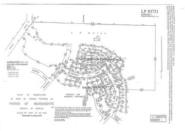
Document - Subdivision Plan, LP83721 Part of Crown Portion 23, Parish of Warrandyte, County of Evelyn, Vol 8708 Fol 351, Vol 8745 Fol 148 and Vol 8751 Fol 034 - 1969
Double sided LANDATA Land Victoria 2-sheet plan printout dated 2009Sheet 1 map and Sheet 2 enlargement including Wonga Road, Holyrood Crescent, Harwick Close, Berkley Road, Frederic Drive, Kenwood Crescent, Adele Court and Marilyn Street, Ringwood. Markings also include LP83722 . -
 Ringwood and District Historical Society
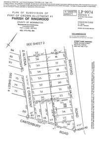
Document - Subdivision Plan, LP9974 Part of Crown Allotment 41, Parish of Ringwood, County of Mornington Vol 1773 Fol 464 - 1924
LANDATA Land Victoria 4-sheet plan printout dated 2009Sheet 1 includes Alvena Crescent, Bedford Road and Canterbury Road, Heathmont. Additional markings include RP16869. Sheet 2 includes Alvena Crescent and Bedford Road, Heathmont. Additional markings include PS318390 and CP161633. Sheet 3 includes Bedford Road, Alvena Crescent and Royal Avenue, Heathmont. Additional markings include RP454. Street name amended from Leonard Street to Royal Avenue Vide Gaz 1962 P.427. Sheet 4 includes Alvena Crescent, Royal Avenue, Coleman Street and Canterbury Road, Heathmont. Additional markings include SP27861, PS305057, RP10566, SP34722 and LP116573. -
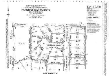 Ringwood and District Historical Society
Document - Subdivision Plan, LP113220 Part of Crown Section 23, Parish of Warrandyte, County of Evelyn Vol 8970 Fol 687 - 1975
LANDATA Land Victoria 2-sheet plan printout dated 2009Sheet 1 includes Wonga Road, Holyrood Crescent and Georgian Court, Ringwood. Sheet 2 includes Wonga Road, Holyrood Crescent and Stonington Place, Ringwood. -
 Ringwood and District Historical Society
Document - Subdivision Map, Part of Crown Sections 18, 19, 24 & 25, Parish of Warrandyte, County of Evelyn, Vol 5228 Fol 472 - 1926. (Park Orchards, Victoria)
... and Gosford Crescent, Park Orchards, Victoria.... and Gosford Crescent, Park Orchards, Victoria. A3 and A4 sized ...A3 and A4 sized photocopies showing map section of land title showing streets, easements and allotment numbers, some with handwritten names and pricing notations circa mid 1950s.Map includes Valley Road, Granard Avenue, Park Road, Arundel Avenue, Hylton Avenue, Aviemore Avenue, Bowmore Avenue, Hopetoun Road, Colin Avenue, Daintree Avenue, Brucedale Crescent, Feversham Avenue, Ennismore Crescent, Iona Grove, Elgin Crescent and Gosford Crescent, Park Orchards, Victoria. -
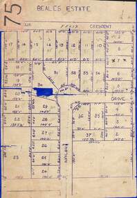 Ringwood and District Historical Society
Map, Subdivision Plan of 37 residential allotments on Panorama Avenue, Felix Crescent, Evelyn Road and Avalon Grove, Ringwood, Victoria - (Undated - circa 1960)
Stencilled copy of map on blue cardboard backingBeales Estate -
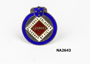 Whitehorse Historical Society Inc.
Badge, c1920
Lapel badge of Mr W.H.Arrowsmith, grandfather of donor and founder secretary of the Father's Association. see also NA2643Circular badge surmounted with Victorian flag insignia - red, blue and white. Unusual crescent moon hook for lapel on reverse. Stamped numbers on reverse. - Sailors, Soldiers Association of Victoria a forerunner of the RSL.On reverse : R92650 R.J.King|(896 (upside Down)numismatics, badges -
![Ivory silk and lace wedding dress [bodice]](/media/collectors/550653872162f11fb04854aa/items/644fb461495d06a04226c26a/item-media/644fb5fd495d06a04226db5d/item-fit-380x285.jpg) Kew Historical Society Inc
Kew Historical Society IncClothing - Ivory silk crepe and lace bodice, 1912
This bodice was part of the wedding outfit worn by Grace Burland at her marriage to John Henty Hindson in 1912. Her husband's grandfather, Francis Henty, was the youngest son of Thomas Henty, who with his family, their retainers and property moved to the Australian colonies between 1829 and 1832. In 1834, Francis’ older brother, Edward, sailed from Launceston in Van Diemen’s Land to what was to become Portland in the western part of Port Phillip District [Victoria]. Francis, together with the first flock of Merino sheep [in Victoria], followed some months later. The first and second generations of the Henty family established vast pastoral properties in the Western part of the Port Phillip District. Francis Henty managed ‘Merino Downs’ near Casterton, while also living in his retirement at ‘Field Place' in Kew.The Henty Collection of nineteenth and twentieth century clothing, including outerwear and underwear, was collected, stored and exhibited over time by female family members descended from Francis and Mary Ann Henty. During the twentieth century, items from the collection were modelled in two fashion parades by various descendants [1937, 1959]. The items in the collection are historically and aesthetically significant, with provenance provided by oral and written tradition within or held by the family. A number of the items in the collection are very rare survivors, and provide researchers with the evidence needed to reconstruct the lives of notable women in the Port Phillip District [later Victoria] during the nineteenth and early twentieth century.Silk crepe wedding bodice decorated with Mechlin lace, pearls and jet, which was worn by Grace Burland at her marriage to John Henty Hindson in 1912. A report in Punch [12 September 1912] described her outfit as “... white crepe de chene finished with Mechlin lace and pearl trimming; also pearl crescent brooch (gift of the bridegroom' s mother).” Mechlin lace or Point de Malines is an old bobbin lace, one of the best-known Flemish laces, originally produced in Mechelen, Belgium. Used for women's clothing, it was popular until the first decade of the twentieth century. The high silk net neckline is finished with pearls. These are repeated on the loose fitted diagonal ornamentation on the front and back which is finished with pearl and jet beading. Similar ornamentation finishes the elbow length sleeves. [The wedding skirt is not part of the donation]. wedding dresses, women's clothing, fashion -- 1910s, bodices, grace burland -
Glen Eira Historical Society
Letter - Rosstown Railway
This file contains four items: 1/A black and white photocopy of a letter dated either 07/08/1889 or 09/08/1889, from Robert Lundon to an unidentified recipient discussing an agreement reached between the author – on behalf of the recipient – and Soon Hang Hi in regard, in regards to the allotment known as Webber’s. The agreement is outlined in the letter in what appears to be Chinese characters, and includes the marks of Robert Lundon and Soon Hang Hi. File note from Joy Wu states that the calligraphy is not Mandarin or traditional Chinese. 2/Three sheets of hand-written working notes with information taken from the Victorian Government Gazette on THE ROSSTOWN AND MURRUMBEENA LAND COMPANY LIMITED, THE ROSSTOWN JUNCTION RAILWAY AND PROSPERITY COMPANY LIOMITED, and THE ROSSTOWN JUNCTION, ELSTERNWICK, AND OAKLEIGH RAILWAY COMPANY LIMITED, covering dates between 1887 and 1894. The notes concern meetings and creditors claims relevant to the companies, with reference numbers for the information source. Date and author of the notes are not recorded. 3/A black and white photocopy of the a partial map of the Rosstown Railway and surrounding area, undated. The map includes the names of landholders in the areas of Brighton, Garden Vale and Elsternwick, as well as other railway lines present in the region. 4/A fold-out map and guide of the Rosstown Rail Trail, including a brief general history of Caulfield as well as a more extensive biography of William Murray Ross and the Rosstown Railway. The map marks and describes significant sites along the trail, including photographs of some of these sites, provided by DF Jowett.documents, correspondence, webber’s, lundon robert, chinese characters, ethnic communities, signatures, text, settlements, taxes, fraser john grieves, lovell r.h., price davies, meetings, communication activities, soon hang hi, commercial events and activities, the rosstown and murrumbeena land company limited, victorian government gazette, bulmer richard, parry john, osment henry, shareholders, creditors claims, the rosstown junction railway and property company limited, finch and best, lawyers, the rosstown junction elsternwick and oakleigh railway company limited, cameron w.c., phillips p.d., garden vale, elsternwick, elsternwick railway station, rosstown, rosstown railway, thomas street, bay street, kooyong road, melbourne and brighton railway, hawthorn road, bambra road, caulfield and frankston railway, booran road, grange road, koornang road, murrumbeena road, north road, north road railway station, east brighton railway station, south road, railway routes, railway lines, railways, land transport, murphy j., caulfield, hamilton t.f., dane p., holloway, webb, ailee john, payne t.b., brodie chas, dane john, o’neil h., mccombie john, mcmillane a., smyth c.d., cooper, ebden, landholders, jeffrey j.d., gill j., balcombe a.e., cooper h., mcnab j., white j., sutherland j., greeves a.f.a., newton m.c., chamley f.b., fowler j., inglis p., grant t., stooke j., swanson g., cochrane c., adams e.b., mccombie thas, keyes robert, brighton cemetery, burials grounds and graveyards, war-ein road, were j.b., holland j., mcmahon c., winter t.l.m., dendy henry, mitchell w., jackson s., were j.e., wickham francis dawe, bryant jane, east brighton railway station, railway stations, maps, allotments, land titles, roads and streets, rosstown rail trail, city of glen eira, tourism, trains, tourism information bureaus, tours, pamphlets, elsternwick railway park, oakleigh junction, princes park, ee gunn reserve, packer park, sites, jowett d.f., weickhardt i.g., return to rosstown: railways land sales and sugar beet ventures in caulfield, land sales, walking trails, ross william murray, transport objects, locomotion, walking, cycling, driving, sports, country mansions, people, caulfield john, builders, construction and demolition workers, occupations, careers, professionals, topography, geology, landforms, horticulture, market gardens, primary industry workers, city of caulfield, mood kee, pennington harold, annual general meetings, caulfield town hall, glen eira city council, carnegie, carnegie station, rosstown station, people by circumstance, migrants, sugar beet, sugar beet mill, sugar beet industry, mills, factories, sea beach lines, bent thomas, parliamentary representatives, neville street, miller street, lemann’s swamp reserve, koornang park, cane sugar industry, breweries, rabbit processing plants, health establishments, hospitals, food production establishments, abattoirs, thieves, social problems, vagrants, theft, squatting, financial economics, debt, finance industry, insurance companies, company managers, bentleigh, ross leila, the grange, leila road, wild cherry road, financial trouble, mortgages, gisborne street, archibald street, riddell parade, victoria railways, glen huntly road, clarence street, college street, gladstone parade, parrell street, aileen avenue, seaview street, land subdivisions, dover street, sussex street, landfill, marara road, booran road, woodville avenue, dorothy avenue, ormond park, royal avenue, ormond railway station, oakleigh road, melten avenue, miller street, munro avenue, lord reserve, neerim road, toolambool road, the rosstown hotel, rosanna street, murrumbeena crescent, commercial establishments, the national bank, rosstown road, kangaroo road, poath road, freda street, hughesdale kindergarten, oakleigh council, hughesdale community centre, civic establishments, galbally reserve, plaques, warrigal road, out and about brochures, orion estate -
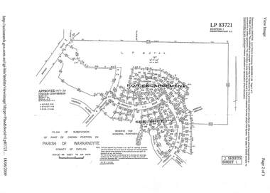 Ringwood and District Historical Society
Document - Subdivision Plan, LP83721 - Part of Crown Portion 23, Parish of Warrandyte, County of Evelyn - 1969
A4 LANDATA Land Victoria plan printout dated 2009Two A4 maps of residential subdivision off Wonga Road, Ringwood. Enlargement map includes Holyrood Crescent, Berkley Road, Carmen Court, Frederic Drive, Kenwood Crescent, Marilyn Street and Adele Court. -
 Ringwood and District Historical Society
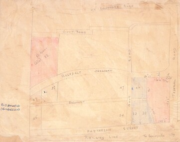
Drawing - Hand-drawn map, Part of Crown Allotment 22, Ringwood East, Victoria (Undated)
Pencil drawing on light cardboard backing. Colour-shaded residential allotments on Rosedale Crescent, Patterson Street and Federal Road, Ringwood East.(Railway line to Healesville marked on the map indicates creation date precedes closure of line beyond Lilydale in 1980) -
 Ringwood and District Historical Society
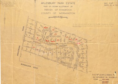
Map - Plan of Subdivision, Aylesbury Park Estate, Part of Crown Allotment 39, Parish of Ringwood, County of Mornington - 1970
Map showing residential allotments for sale in Armstrong Road, Danielle Crescent and Locksley Close, Heathmont, Victoria.Ref.532A Date 13.4.70. Paul Millar & Associates, Land & Engineering Surveyors, 14A Main Street Croydon (Phone) 723 4493. Ref.532A Date 13.4.70. (Agent) H.G. McLean & Assoc P/L, 166 Canterbury Road Heathmont, Phone 8703422 A.H. 8706726 8700112.