Showing 387 items
matching victoria the first century
-
 Kew Historical Society Inc
Plan, Melbourne & Metropolitan Board of Works : Borough of Kew : Detail Plan No.1581, 1904
The Melbourne and Metropolitan Board of Works (MMBW) plans were produced from the 1890s to the 1950s. They were crucial to the design and development of Melbourne's sewerage and drainage system. The plans, at a scale of 40 feet to 1 inch (1:480), provide a detailed historical record of Melbourne streetscapes and environmental features. Each plan covers one or two street blocks (roughly six streets), showing details of buildings, including garden layouts and ownership boundaries, and features such as laneways, drains, bridges, parks, municipal boundaries and other prominent landmarks as they existed at the time each plan was produced. (Source: State Library of Victoria)This plan forms part of a large group of MMBW plans and maps that was donated to the Society by the Mr Poulter, City Engineer of the City of Kew in 1989. Within this collection, thirty-five hand-coloured plans, backed with linen, are of statewide significance as they include annotations that provide details of construction materials used in buildings in the first decade of the 20th century as well as additional information about land ownership and usage. The copies in the Public Record Office Victoria and the State Library of Victoria are monochrome versions which do not denote building materials so that the maps in this collection are invaluable and unique tools for researchers and heritage consultants. A number of the plans are not held in the collection of the State Library of Victoria so they have the additional attribute of rarity.Original survey plan, issued by the MMBW to a contractor with responsibility for constructing sewers in the area identified on the plan within the Borough of Kew. The plan was at some stage hand-coloured, possibly by the contractor, but more likely by officers working in the Engineering Department of the Borough and later Town, then City of Kew. The hand-coloured sections of buildings on the plan were used to denote masonry or brick constructions (pink), weatherboard constructions (yellow), and public buildings (grey). The streets and built structures in this plan were surveyed in 1903 and released to contractors in 1904. In addition to the designation of building types by colour, the plan includes detailed descriptions of land use and ownership. While many buildings remain from this period, a number of the buildings represented have been demolished including the original Kew Town Hall, and the Congregational and Roman Catholic churches in Walpole Street. While the mansion ‘Illapa’ in Princess Street is still extant – now part of ‘Rylands’ – the neighbouring mansion ‘Elsmere’ was demolished some decades ago. Rivalling Illapa and Elsmere in size were two mansions in Walpole Street, one named on the plan as ‘Gnarlbine’. Over time, Kew Junction and the south side of High Street have been reconfigured and widened, so that the commercial buildings on the corner of Princess and High Street no longer exist. A surprising feature of this part of central Kew to the northwest of Kew Junction is the amount of vacant land. In a number of cases, this land is noted by the contractor as used for vegetable gardens.melbourne and metropolitan board of works, detail plans, maps - borough of kew, mmbw 1581, cartography -
 Kew Historical Society Inc
Plan, Melbourne & Metropolitan Board of Works : Borough of Kew : Detail Plan No.1582, 1904
The Melbourne and Metropolitan Board of Works (MMBW) plans were produced from the 1890s to the 1950s. They were crucial to the design and development of Melbourne's sewerage and drainage system. The plans, at a scale of 40 feet to 1 inch (1:480), provide a detailed historical record of Melbourne streetscapes and environmental features. Each plan covers one or two street blocks (roughly six streets), showing details of buildings, including garden layouts and ownership boundaries, and features such as laneways, drains, bridges, parks, municipal boundaries and other prominent landmarks as they existed at the time each plan was produced. (Source: State Library of Victoria)This plan forms part of a large group of MMBW plans and maps that was donated to the Society by the Mr Poulter, City Engineer of the City of Kew in 1989. Within this collection, thirty-five hand-coloured plans, backed with linen, are of statewide significance as they include annotations that provide details of construction materials used in buildings in the first decade of the 20th century as well as additional information about land ownership and usage. The copies in the Public Record Office Victoria and the State Library of Victoria are monochrome versions which do not denote building materials so that the maps in this collection are invaluable and unique tools for researchers and heritage consultants. A number of the plans are not held in the collection of the State Library of Victoria so they have the additional attribute of rarity.Original survey plan, issued by the MMBW to a contractor with responsibility for constructing sewers in the area identified on the plan within the Borough of Kew. The plan was at some stage hand-coloured, possibly by the contractor, but more likely by officers working in the Engineering Department of the Borough and later Town, then City of Kew. The hand-coloured sections of buildings on the plan were used to denote masonry or brick constructions (pink), weatherboard constructions (yellow), and public buildings (grey). Public buildings, coloured grey on the Plan 1582 include the police station and post office, churches and schools. The earliest church school, Common School No.356 was located at the rear of the Congregational Church in Peel Street. It was constructed in 1859. The first buildings of Kew Primary School No.1075 on the other side of Peel Street were constructed in 1871. The school in 1903 only occupied a small fraction of its current site. In 1903, where the rear playground is now located, were two weatherboard and one brick villa. Trinity Grammar School was founded in 1902 and opened in the Parish Hall at the rear of Holy Trinity Anglican Church. It was not to move to its current site until 1906. The outline of the building housing the Kew Fire Brigade in the centre of the north side of Walton Street is shown but not named on the plan. Further down Pakington Street stood the two-storey Italianate mansion ‘Overton’. The home of Stanford Chapman, it was to be featured in the Imperial Institute series of bromide photographs of Victoria, Vol. 1: Homes and scenery. It was later to become a boarding house before it was later demolished.melbourne and metropolitan board of works, detail plans, maps - borough of kew, mmbw 1582, cartography -
 Kew Historical Society Inc
Plan, Melbourne & Metropolitan Board of Works : Borough of Kew : Detail Plan No.1585, 1904
The Melbourne and Metropolitan Board of Works (MMBW) plans were produced from the 1890s to the 1950s. They were crucial to the design and development of Melbourne's sewerage and drainage system. The plans, at a scale of 40 feet to 1 inch (1:480), provide a detailed historical record of Melbourne streetscapes and environmental features. Each plan covers one or two street blocks (roughly six streets), showing details of buildings, including garden layouts and ownership boundaries, and features such as laneways, drains, bridges, parks, municipal boundaries and other prominent landmarks as they existed at the time each plan was produced. (Source: State Library of Victoria)This plan forms part of a large group of MMBW plans and maps that was donated to the Society by the Mr Poulter, City Engineer of the City of Kew in 1989. Within this collection, thirty-five hand-coloured plans, backed with linen, are of statewide significance as they include annotations that provide details of construction materials used in buildings in the first decade of the 20th century as well as additional information about land ownership and usage. The copies in the Public Record Office Victoria and the State Library of Victoria are monochrome versions which do not denote building materials so that the maps in this collection are invaluable and unique tools for researchers and heritage consultants. A number of the plans are not held in the collection of the State Library of Victoria so they have the additional attribute of rarity.Original survey plan, issued by the MMBW to a contractor with responsibility for constructing sewers in the area identified on the plan within the Borough of Kew. The plan was at some stage hand-coloured, possibly by the contractor, but more likely by officers working in the Engineering Department of the Borough and later Town, then City of Kew. The hand-coloured sections of buildings on the plan were used to denote masonry or brick constructions (pink), weatherboard constructions (yellow), and public buildings (grey). This plan, which covers parts of High Street, Pakington Street and Derby Street is dominated by two historic Kew mansions: ‘Konetta’ and ‘Ramornie’. Ramornie was constructed in 1890 for James Maitland Campbell, three times Mayor of Kew. Sold in 1940, it became a boarding house known as ‘The Towers’. Now a private residence again, it has only one of its three balconies remaining. The location of the missing two balconies can be seen on the plan. In 1903, the grounds of Ramornie included a large tennis court fronting Pakington Street. The rear of the property is shown as extending to Cobden Street. One of Kew’s oldest hotels, the Prospect Hill Hotel on the corner of High and Cobden Street was established in 1858. The outline of the hotel shown on the plan represents the second building on the site. During the 19th century it was often used for electoral meetings. The Prospect Hill Hotel was to be redeveloped again in 1928, by the local architect Robert McIntyre. Since the 1980s, the hotel has been a live music venue, the home of the Melbourne Jazz Club, a restaurant and a liquor outlet.melbourne and metropolitan board of works, detail plans, maps - borough of kew, mmbw 1585, cartography -
 Kew Historical Society Inc
Plan, Melbourne & Metropolitan Board of Works : Borough of Kew : Detail Plan No.1588, 1904
The Melbourne and Metropolitan Board of Works (MMBW) plans were produced from the 1890s to the 1950s. They were crucial to the design and development of Melbourne's sewerage and drainage system. The plans, at a scale of 40 feet to 1 inch (1:480), provide a detailed historical record of Melbourne streetscapes and environmental features. Each plan covers one or two street blocks (roughly six streets), showing details of buildings, including garden layouts and ownership boundaries, and features such as laneways, drains, bridges, parks, municipal boundaries and other prominent landmarks as they existed at the time each plan was produced. (Source: State Library of Victoria)This plan forms part of a large group of MMBW plans and maps that was donated to the Society by the Mr Poulter, City Engineer of the City of Kew in 1989. Within this collection, thirty-five hand-coloured plans, backed with linen, are of statewide significance as they include annotations that provide details of construction materials used in buildings in the first decade of the 20th century as well as additional information about land ownership and usage. The copies in the Public Record Office Victoria and the State Library of Victoria are monochrome versions which do not denote building materials so that the maps in this collection are invaluable and unique tools for researchers and heritage consultants. A number of the plans are not held in the collection of the State Library of Victoria so they have the additional attribute of rarity.Original survey plan, issued by the MMBW to a contractor with responsibility for constructing sewers in the area identified on the plan within the Borough of Kew. The plan was at some stage hand-coloured, possibly by the contractor, but more likely by officers working in the Engineering Department of the Borough and later Town, then City of Kew. The hand-coloured sections of buildings on the plan were used to denote masonry or brick constructions (pink), weatherboard constructions (yellow), and public buildings (grey). This plan shows the original configuration of the Kew Post Office, Court House and Police Station, which had opened in 1888. This configuration was to essentially remain until the purchase of the Court House and Police Station by the City of Boroondara in 2007 and its subsequent renovation. Interestingly, the MMBW surveyors incorrectly labelled parts of the complex. In the triangle in front of the Post Office, before the erection of the Kew Cenotaph in 1925, was located a lawn and the Queen Victoria Jubilee Fountain. While many of the shops on the south side of High street had been constructed by 1903 a number of sites were still used as vegetable gardens. Further along High Street, on the corner of Charles Street, the Salvation Army Barracks can be seen on the plan. These Barracks predate the later Citadel and ‘Young People’s Hall’ that were opened in 1919. At 22 Charles Street can be seen the house of James Venn Morgan. Hailed as the ‘father of Kew’, Morgan arrived in Melbourne in 1840. He was first engaged as a bookmaker, but a fortunate venture on the goldfields enabled him to purchase land in Kew. He conducted a market garden and dairy in Kew for many years.melbourne and metropolitan board of works, detail plans, maps - borough of kew, mmbw 1588, cartography -
 Kew Historical Society Inc
Plan, Melbourne & Metropolitan Board of Works : Borough of Kew : Detail Plan No.1590, 1905
The Melbourne and Metropolitan Board of Works (MMBW) plans were produced from the 1890s to the 1950s. They were crucial to the design and development of Melbourne's sewerage and drainage system. The plans, at a scale of 40 feet to 1 inch (1:480), provide a detailed historical record of Melbourne streetscapes and environmental features. Each plan covers one or two street blocks (roughly six streets), showing details of buildings, including garden layouts and ownership boundaries, and features such as laneways, drains, bridges, parks, municipal boundaries and other prominent landmarks as they existed at the time each plan was produced. (Source: State Library of Victoria)This plan forms part of a large group of MMBW plans and maps that was donated to the Society by the Mr Poulter, City Engineer of the City of Kew in 1989. Within this collection, thirty-five hand-coloured plans, backed with linen, are of statewide significance as they include annotations that provide details of construction materials used in buildings in the first decade of the 20th century as well as additional information about land ownership and usage. The copies in the Public Record Office Victoria and the State Library of Victoria are monochrome versions which do not denote building materials so that the maps in this collection are invaluable and unique tools for researchers and heritage consultants. A number of the plans are not held in the collection of the State Library of Victoria so they have the additional attribute of rarity.Original survey plan, issued by the MMBW to a contractor with responsibility for constructing sewers in the area identified on the plan within the Borough of Kew. The plan was at some stage hand-coloured, possibly by the contractor, but more likely by officers working in the Engineering Department of the Borough and later Town, then City of Kew. The hand-coloured sections of buildings on the plan were used to denote masonry or brick constructions (pink), weatherboard constructions (yellow), and public buildings (grey). Surveyed by the Board of Works in 1903 and published in 1904, Plan No.1590 shows development north of Cotham Road. While this plan includes built structures in Mary Street, Cotham Road, High Street, Park Hill Road, Kent Street, Ridgeway Avenue, and Ermington Lane (now Ermington Place), only part of this section was notated and coloured in this contractor’s copy. Numerous houses, large and small are named on the plan: ‘Cholula’, ‘Belper’, ‘The Uplands’, ‘Spring Grove’ facing Cotham Road; ‘Marion’ facing Kent Street; and ‘Kia Ora’ facing Ridgeway Avenue.melbourne and metropolitan board of works, detail plans, mmbw 1590, survey plans - borough of kew, cartography -
 Kew Historical Society Inc
Plan, Melbourne & Metropolitan Board of Works : Borough of Kew : Detail Plan No.1591, 1905
The Melbourne and Metropolitan Board of Works (MMBW) plans were produced from the 1890s to the 1950s. They were crucial to the design and development of Melbourne's sewerage and drainage system. The plans, at a scale of 40 feet to 1 inch (1:480), provide a detailed historical record of Melbourne streetscapes and environmental features. Each plan covers one or two street blocks (roughly six streets), showing details of buildings, including garden layouts and ownership boundaries, and features such as laneways, drains, bridges, parks, municipal boundaries and other prominent landmarks as they existed at the time each plan was produced. (Source: State Library of Victoria)This plan forms part of a large group of MMBW plans and maps that was donated to the Society by the Mr Poulter, City Engineer of the City of Kew in 1989. Within this collection, thirty-five hand-coloured plans, backed with linen, are of statewide significance as they include annotations that provide details of construction materials used in buildings in the first decade of the 20th century as well as additional information about land ownership and usage. The copies in the Public Record Office Victoria and the State Library of Victoria are monochrome versions which do not denote building materials so that the maps in this collection are invaluable and unique tools for researchers and heritage consultants. A number of the plans are not held in the collection of the State Library of Victoria so they have the additional attribute of rarity.Original survey plan, issued by the MMBW to a contractor with responsibility for constructing sewers in the area identified on the plan within the Borough of Kew. The plan was at some stage hand-coloured, possibly by the contractor, but more likely by officers working in the Engineering Department of the Borough and later Town, then City of Kew. The hand-coloured sections of buildings on the plan were used to denote masonry or brick constructions (pink), weatherboard constructions (yellow), and public buildings (grey). That area of Kew bordered by Cotham Road, Park Hill Road, Ermington Lane (now Ermington Place), and Belmont Avenue contained some of the significant homes owned by Kew pioneers. Chief among these was ‘Park Hill’ on an enormous lot facing Park Hill Road. The Jubilee History of 1910 noted, six years after this plan was drawn, that: ‘Park Hill Road, forming the southern boundary of the cemetery, takes its name from Park Hill, the residence of Mr. Thomas Judd, who has resided there since December, 1852.’ Other named houses on the plan include ‘Ferndale’ facing Cotham Road; ‘Ermington’ adjacent to Judd’s Park Hill, facing Park Hill Road; and ‘Gilden’ and ‘Mont Belmont’ facing Belmont Avenue. Mont Belmont was designed by the architectural firm of Reed, Henderson and Smart for William George Lilley in 1887 and was completed in 1888. Lilley was Mayor of Kew in 1887-88, a Justice of the Peace and a member of the first Board of Guardians of Kew’s St. Hilary’s Church of England.melbourne and metropolitan board of works, detail plans, survey plans - borough of kew, mmbw 1591, cartography -
 Kew Historical Society Inc
Plan, Melbourne & Metropolitan Board of Works : Borough of Kew : Detail Plan No.1592, 1905
The Melbourne and Metropolitan Board of Works (MMBW) plans were produced from the 1890s to the 1950s. They were crucial to the design and development of Melbourne's sewerage and drainage system. The plans, at a scale of 40 feet to 1 inch (1:480), provide a detailed historical record of Melbourne streetscapes and environmental features. Each plan covers one or two street blocks (roughly six streets), showing details of buildings, including garden layouts and ownership boundaries, and features such as laneways, drains, bridges, parks, municipal boundaries and other prominent landmarks as they existed at the time each plan was produced. (Source: State Library of Victoria). This plan forms part of a large group of MMBW plans and maps that was donated to the Society by the Mr Poulter, City Engineer of the City of Kew in 1989. Within this collection, thirty-five hand-coloured plans, backed with linen, are of statewide significance as they include annotations that provide details of construction materials used in buildings in the first decade of the 20th century as well as additional information about land ownership and usage. The copies in the Public Record Office Victoria and the State Library of Victoria are monochrome versions which do not denote building materials so that the maps in this collection are invaluable and unique tools for researchers and heritage consultants. A number of the plans are not held in the collection of the State Library of Victoria so they have the additional attribute of rarity.Original survey plan, issued by the MMBW to a contractor with responsibility for constructing sewers in the area identified on the plan within the Borough of Kew. The plan was at some stage hand-coloured, possibly by the contractor, but more likely by officers working in the Engineering Department of the Borough and later Town, then City of Kew. The hand-coloured sections of buildings on the plan were used to denote masonry or brick constructions (pink), weatherboard constructions (yellow), and public buildings (grey). In MMBW Plan No.1592, the pink line indicates that area of the plan for which the contracting engineer was responsible. Included in the Plan are a number of primarily brick villas in a section of Belmont Avenue off Cotham Road. The house ‘Uvadale’ north of Belmont Avenue, and facing Cotham Road is also included in the contract. Excluded from the contract but shown on the Plan are ‘Glendonald’, ‘Mont Belmont’ and ‘Gilden’.melbourne and metropolitan board of works, detail plans, survey plans - borough of kew, mmbw 1592, cartography -
 Kew Historical Society Inc
Plan, Melbourne & Metropolitan Board of Works / Borough of Kew, Detail Plan No.1593, 1905
The Melbourne and Metropolitan Board of Works (MMBW) plans were produced from the 1890s to the 1950s. They were crucial to the design and development of Melbourne's sewerage and drainage system. The plans, at a scale of 40 feet to 1 inch (1:480), provide a detailed historical record of Melbourne streetscapes and environmental features. Each plan covers one or two street blocks (roughly six streets), showing details of buildings, including garden layouts and ownership boundaries, and features such as laneways, drains, bridges, parks, municipal boundaries and other prominent landmarks as they existed at the time each plan was produced. (Source: State Library of Victoria)This plan forms part of a large group of MMBW plans and maps that was donated to the Society by the Mr Poulter, City Engineer of the City of Kew in 1989. Within this collection, thirty-five hand-coloured plans, backed with linen, are of statewide significance as they include annotations that provide details of construction materials used in buildings in the first decade of the 20th century as well as additional information about land ownership and usage. The copies in the Public Record Office Victoria and the State Library of Victoria are monochrome versions which do not denote building materials so that the maps in this collection are invaluable and unique tools for researchers and heritage consultants. A number of the plans are not held in the collection of the State Library of Victoria so they have the additional attribute of rarity.Original survey plan, issued by the MMBW to a contractor with responsibility for constructing sewers in the area identified on the plan within the Borough of Kew. The plan was at some stage hand-coloured, possibly by the contractor, but more likely by officers working in the Engineering Department of the Borough and later Town, then City of Kew. The hand-coloured sections of buildings on the plan were used to denote masonry or brick constructions (pink), weatherboard constructions (yellow), and public buildings (grey). The laborious task of hand-tinting these Board of Works plans was not without hazards as is evidenced by Plan No. 1593. On the Plan, the original colourist spilt black and green ink, partially obscuring some parts. The most obvious casualty is ‘Clifton’ located on the corner of Cotham Road and Park Street [now Adeney Avenue]. Included in this Plan, and outlined in pink is that part of the section that the contracting engineer was tasked with completing. This included sewering on both sides of this part of Cotham Road, but excluded properties such as ‘Glendonald’ and ‘Monnington’. This area was to undergo a series of subdivisions including the ‘Clifton Estate’, which created housing lots on Adeney Avenue and Florence Avenue in 1916. The most notable occupant of Clifton was William Adeney [died 1893], a pioneer of Camperdown, after which Park Street was later renamed.melbourne and metropolitan board of works, detail plans, survey plans - borough of kew, mmbw 1593, cartography -
 Kew Historical Society Inc
Plan, Melbourne & Metropolitan Board of Works : Contour Plan of Melbourne & Suburbs : Melbourne Sewage, 1894
The Melbourne and Metropolitan Board of Works (MMBW) plans were produced from the 1890s to the 1950s. They were crucial to the design and development of Melbourne's sewerage and drainage system. This plan forms part of a large group of MMBW plans and maps that was donated to the Society by the Mr Poulter, City Engineer of the City of Kew in 1989. Within this collection, thirty-five hand-coloured plans, backed with linen, are of statewide significance as they include annotations that provide details of construction materials used in buildings in the first decade of the 20th century as well as additional information about land ownership and usage. The copies in the Public Record Office Victoria and the State Library of Victoria are monochrome versions which do not denote building materials so that the maps in this collection are invaluable and unique tools for researchers and heritage consultants. A number of the plans are not held in the collection of the State Library of Victoria so they have the additional attribute of rarity.Digital copy of an original MMBW plan. This contour plan shows the area identified by the MMBW for purposes of drainage and sewerage in 1894. The suburbs represented extend from Williamstown in the west to Bulleen in the east, and from Preston in the north, south to Sandringham. Suburbs are outlined in coloured ink. Red lines indicate main and branch sewers in existence at the beginning of 1894 in central and inner Melbourne. These extended as far as Williamstown and Brighton, but not yet as far as Kew, where sewering did not commence until 1901. Contour lines show the topography, which was important for indicating the fall of the land for the laying of sewers and drainage channels. Kew appears to be fairly undeveloped at this date except for railway lines and stations (the Kew and Outer Circle lines), main roads, the Kew Lunatic Asylum Reserve and Studley Park. However, the contour plan does not accurately represent the density of settlement, nor the large number of houses, which were being built in Kew and other suburbs from the 1850s to the land boom of the late 1880’s and early 1890’s. This plan is part of a large and historically significant group of MMBW plans and maps that was donated to the Society by the Mr Poulter, City Engineer of the City of Kew in 1989.mmbw contour plan of melbourne and suburbs, melbourne and metropolitan board of works, melbourne sewage, cartography -
 Kew Historical Society Inc
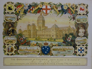
Document - Invitation to a ‘Conversazione’ in the Exhibition Building, George Austin, 1901
A report in the Ballarat Star on 8 May 1901 recorded that: "THE CONVERSAZIONE. A GREAT SUCCESS. The conversazion given by the Government of Victoria at the Exhibition was very largely patronised. the guests includ ing the Prime Minister and a goodly proportion of the distinguished personages now in Melbourne. A programme of high-class music was gone through, and refreshments were served during the evening. Australian wines were very prominent."The document design has artistic and aesthetic merit. While it is not rare, it is representative of the kinds of formal designs used for the Australian Commonwealth celebrations at the time of Federation, and is in excellent condition. Such items as this invitation have local, state and national historic significance as mementoes of a key moment in Australia's history. Locally, the invitation is part of a group of Federation-related items issued to James Maitland Campbell (and his wife). Campbell was three times mayor of Kew in the second half of the 19th Century and the owner of Ramornie in Pakington Street, one of the significant extant mansions in Kew.Colour lithograph mounted on card to an evening event, a conversazione, held in the Exhibition Building on the evening of Tuesday 7th May 1901, as part of the Australian Commonwealth Celebrations. The recipients of the invitation were Mr and Mrs James Maitland Campbell of Kew. The Government of Victoria hosted the event. The invitation shows an etching of the Exhibition Building, surrounded by an ornate border of heraldic shields, portraits of the Duke and Duchess, views of Perth, Adelaide, Melbourne, Sydney, Brisbane and Hobart, and native flora (including wattle, waratah, pink heath, Sturt’s desert pea, and flannel flower), and native fauna (kookaburra, possum, lyre bird, cockatoo and koala). The royal crest ‘Dieu et mon droit’ and the Australian crest, ‘Advance Australia’ are also included.Printed: UNITED AUSTRALIA 1901 / ONE FLAG / ONE HOPE / ONE DESTINY; AUSTRALIAN COMMONWEALTH CELEBRATIONS / THE GOVERNMENT OF VICTORIA requests the honour of the presence of / / at a Conversazione in the Exhibition Building on the Evening of Tuesday 7th May 1901 at 8 P.M. Handwritten: Mr & Mrs J. M. Campbell.sands & mcdougall ltd, documents - invitations, first commonwealth parliament 1901, james maitland campbell (1847-1930), ramornie, ramornie - pakington street -
 Kew Historical Society Inc
Legal record - The Indenture, Crown Portion 86, otherwise known as 'The Morgan Deed', 1852 (and later)
This indenture once formed part of the City of Kew's Municipal Collection. Cr. W.D. Vaughan in his history 'Kew's Civic Century' (1960) records on page 194 that: "The original deed of conveyance of the land being all of Crown Portion 86, Kew, purchased by John Quick, James Venn Morgan, Samuel Derrick and William Derrick was presented by the Historical Society of Victoria on behalf of Mrs Fryer, a daughter of the later J.V. Morgan, to the [Kew] Council on August 5, 1941. Crown Portion 86, comprised all the land between Cotham Road and High Street to an alignment opposite the east boundary of Glenferrie Road. On it the first residential house was built by Mr. J.V. Morgan in 1852." Following the donation, the Indenture was surrounded by other original related text and explanatory notes and framed. The resulting framed documents are the largest framed objects in the collection.The Indenture and the accompanying contextual documents are some of the most historically significant manuscripts to have survived since the settlement of Kew in the 1850s. They provide a link to Kew's most famous pioneering families.Framed 1952 Indenture recording the sale of land in Kew to pioneering Kew families.james venn morgan, john quick, william derrick, samuel derrick, kew (vic) - history, kew (vic) - pioneers, samuel watts, kew (vic.) — municipal collection -
 Kew Historical Society Inc
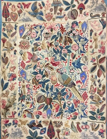
Decorative object - Cotton chintz applique on linen wall hanging [Broderie Perse], 19th Century
This broderie perse' wall hanging was donated to the Kew Historical Society in 1980 by Mrs Joy Ivory. The hanging had belonged to her mother - Amy Grigg - and was used by the latter to demonstrate skills in darning (the red stitching). Provenance includes a certificate dating from 1889 which records an award to Amy Grigg of Pakington Street (Kew) for skills in needlework, issued by the Kew Floral Industrial & Art Society. Amy Grigg later married Albert Watson, the son of John Watson. The latter was an early pastor of the Kew Methodist Church in Highbury Grove, Kew. Both the Watson and Grigg families were early pioneers of Kew. While the hanging was modified by Amy Grigg in 1889, the original textile dates from an earlier period when 'Broderie Perse' (Persian embroidery) was used to create quilts and wall hangings. It is estimated that the hanging dates from the first half of the 19th century. An exact dating will require a detailed examination of the cotton chintz fabrics used to embroider the hanging. This appliquéd wall hanging is one of the earliest textiles in the Kew Historical Society's fashion & textiles collection. Similar examples are held in major international collections such as the Victoria & Albert Museum. This example of broderie perse is significant for the cross-cultural influence of Indian textiles on European taste, not unusual given the English foothold in India during this period. Additional interest is due to the mixing of Indian and European textiles in the design, while staying true to the derivation of the design. The textile is both well-provenanced and rare. While it is unlikely to be Australian-made, it is probably an example of a textile brought to Australia during the colonial period that indicates a desire to decorate interiors using items created in and for the English home. On another level, the wall hanging is a fine example of 'women's work' in the first half of the nineteenth century.Small wall hanging, comprised of five panels that are each appliquéd by hand in herringbone stitch using a range of decorative figurative motifs including flora and fauna. The design is based on an Indian palimpore representing a tree of life design. The base textile is a cream linen while the appliquéd figures or shapes are cut from cotton chintz. These additions are probably a mix of Indian and European designs. The quality of the herringbone stitching is very fine. Later stitching in red wool was added in the 1890s to demonstrate skill in darning. The main panel is bordered by a narrow green and ecru braid. It has a narrow tan braid at the top and bottom of the two side panels. A surrounding tan braid around the entire textile is missing in some places. textiles, applique, broderie perse, amy grigg, wall hangings, migration -
 Kew Historical Society Inc
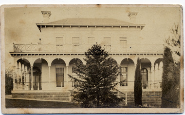
Photograph - 'Clutha', Studley Park Road, 1860-1890
Clutha was the home of John Carson, the second mayor of Kew. Leonard Terry designed the house for him in 1856. Terry was the architect of the Melbourne Club (1858), the former London Chartered Bank (1861), Lothian Terrace in Carlton (1865), and the ES&A Bank in Hawthorn (1873). The commission for Clutha was won three years after Terry’s arrival in Victoria.An extremely rare photograph of a major residential architectural commission of Leonard Terry. The photograph of the house has statewide significance as the home of the Victorian pioneer and businessman, John Carson. A rare, nineteenth century photograph of ‘Clutha’ in Studley Park Road, Kew. The sepia-toned photograph is of the front of the house, with its bluestone foundations and its second storey balcony. A real estate advertisement in 1875 described the house as: 'First-class family mansion, and about 8½ acres of pleasure grounds and fruit garden. The house, erected under the plans and supervision of Mr. Leonard Terry, is most substantially built of brick, stuccoed, on solid bluestone pediment, forming a noble basement story, large entrance hall, and lobby, with conservatory on the left. *** A wide verandah and balcony, erected on cast-iron columns, runs round the house, the views from which are perhaps unequalled in extent and beauty in the neighbourhood of the city, commanding the bay, shipping, Mount Macedon, and Dandenong Ranges. Th e whole forming a most complete gentleman's residence, no expense having been spared in its erection and comfortable finish.'"Clutha West Side Studley Park Road Kew / Clutha West Side"clutha, john carson, leonard terry -
 Kew Historical Society Inc
Accessory - Container of face powder, Guerlaine, 1920s
The French Collection was donated to the Society in 2022. This collection includes documents, artworks, books, costumes and artefacts belonging to two families. A number belonged to, or were made by the grandparents of the donor: Vida May Wing and her husband Hubert Charles McDonald. [Other items belonging to Vida and Hubert are in the collections of the Australian Performing Arts Museum and Museum Victoria.] A second significant group of objects were gifts made to the donor's family by Lucy (Jean) Hornby of Queen Street, Kew whose family had been early settlers in the district. Vida May Wing was born in Richmond in 1882. A noted teacher of plain, fancy and step dancing, during the first two decades of the twentieth century she held annual fancy dancing and floral balls, where her pupils were the performers. In 1916, she married Hubert Charles McDonald. She died in 1959.Round box of Guerlaine [established 1828] face powder. The name of the manufacturer is embossed on the base. The navy blue and gold cardboard container is filled with the original powder by Guerlain Shalimar, 'Ocre Doree'. It belonged to to Vida May McDonald.Reverse: "Guerlaine"guerlaine, vida may wing, cosmetics, face powder -
 Kew Historical Society Inc
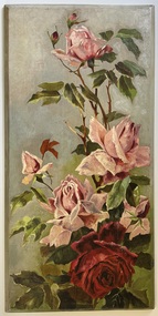
Painting - Rose study, Vida May Wing, 1908-19
The French Collection was donated to the Society in 2022. This collection includes documents, artworks, books, costumes and artefacts belonging to two families. A number belonged to, or were made by the grandparents of the donor: Vida May Wing and her husband Hubert Charles McDonald. [Other items belonging to Vida and Hubert are in the collections of the Australian Performing Arts Museum and Museum Victoria.] A second significant group of objects were gifts made to the donor's family by Lucy (Jean) Hornby of Queen Street, Kew whose family had been early settlers in the district. Vida May Wing was born in Richmond in 1882. A noted teacher of plain, fancy and step dancing, during the first two decades of the twentieth century she held annual fancy dancing and floral balls, where her pupils were the performers. In 1916, she married Hubert Charles McDonald. She died in 1959.Rose Study on board, by Vida May McDonald (nee Wing). Pink and red roses on wooden panel.Reverse: "Vida Wing / 1908-19?"still lifes, vida may wing, roses -
 Kew Historical Society Inc
Functional object - Upright, embossed celluloid, silk lined vanity dresser box, 1904-1914
The French Collection was donated to the Society in 2022. This collection includes documents, artworks, books, costumes and artefacts belonging to two families. A number belonged to, or were made by the grandparents of the donor: Vida May Wing and her husband Hubert Charles McDonald. [Other items belonging to Vida and Hubert are in the collections of the Australian Performing Arts Museum and Museum Victoria.] A second significant group of objects were gifts made to the donor's family by Lucy (Jean) Hornby of Queen Street, Kew whose family had been early settlers in the district. Vida May Wing was born in Richmond in 1882. A noted teacher of plain, fancy and step dancing, during the first two decades of the twentieth century she held annual fancy dancing and floral balls, where her pupils were the performers. In 1916, she married Hubert Charles McDonald. She died in 1959.Upright, embossed celluloid, silk iined vanity dresser box which belonged to Vida May McDonald (nee Wing). The sides of the box are covered with purple figured velvet while the lids are covered with embossed celluloid. The case has a number of panels which open to reveal its pink silk lined interior which was once fitted out with mirrors, combs, brushes, and makeup jars. Nilvida may wing, vida may mcdonald, beauty cases, makeup boxes -
 Kew Historical Society Inc
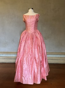
Clothing - Girl's dress, 1858
This dress belonged to Alice Frances Henty (1852-1932) the youngest daughter of Francis Henty (1815-89) and his wife Mary Ann Henty [nee Lawrence] (1821-81). It is recorded that Alice wore the dress at the age of six. Alice's father, Francis Henty, was the youngest son of Thomas Henty, who with his family, their retainers and property moved to the Australian colonies between 1829 and 1832. In 1834, Francis’ older brother, Edward, sailed from Launceston in Van Diemen’s Land to what was to become Portland in the western part of Port Phillip District [Victoria]. Francis, together with the first flock of Merino sheep [in Victoria], followed some months later. The first and second generations of the Henty family established vast pastoral properties in the Western part of the Port Phillip District. Francis Henty managed ‘Merino Downs’ near Casterton, while also living in his retirement at ‘Field Place' in Kew. The Henty Collection of nineteenth and twentieth century clothing, including outerwear and underwear, was collected, stored and exhibited over time by female family members descended from Francis and Mary Ann Henty. During the twentieth century, items from the collection were modelled in two fashion parades by various descendants [1937, 1959]. The items in the collection are historically and aesthetically significant, with provenance provided by oral and written tradition within or held by the family. A number of the items in the collection are very rare survivors, and provide researchers with the evidence needed to reconstruct the lives of notable women in the Port Phillip District [later Victoria] during the nineteenth and early twentieth century.Girl's two-tone, one-piece cotton voile dress from the 1850s has a high round neck and short sleeves has a lace insert on the front of the bodice and matching lace at the rear. The layered skirt is bordered with lace. Measurements (mm): Girth - Neck 609.6, Chest 635, Waist 558.8, Cuff 203.2, Hem circumference 2108.2. Vertical - Front neck to hem 685.8, Front waist to hem 508, Back neck to hem 723.9, Back waist to hem 534.4, Sleeve length 63.5. Horizontal - Neck to sleeve head 38.1, Cross back 304.8, Underarm to underarm 406.4.fashion -- 1850s, children's clothing, alice frances henty -
 Kew Historical Society Inc
Clothing - Two-piece pink silk afternoon outfit, 1875
This afternoon dress was owned and first worn in 1875 by Alice (Henty) Hindson, the daughter of Francis Henty and Mary Ann (Lawrence) Henty. The outfit was worn in the same year as Alice's marriage to John Hindson at Trinity Church, East Melbourne, and may have formed part of her trousseau. Alice's father, Francis Henty, was the youngest son of Thomas Henty, who with his family, their retainers and property moved to the Australian colonies between 1829 and 1832. In 1834, Francis’ older brother, Edward, sailed from Launceston in Van Diemen’s Land to what was to become Portland in the western part of Port Phillip District [Victoria]. Francis, together with the first flock of Merino sheep [in Victoria], followed some months later. The first and second generations of the Henty family established vast pastoral properties in the Western part of the Port Phillip District. Francis Henty managed ‘Merino Downs’ near Casterton, while also living in his retirement at ‘Field Place' in Kew. The Henty Collection of nineteenth and twentieth century clothing, including outerwear and underwear, was collected, stored and exhibited over time by female family members descended from Francis and Mary Ann Henty. During the twentieth century, items from the collection were modelled in two fashion parades by various descendants [1937, 1959]. The items in the collection are historically and aesthetically significant, with provenance provided by oral and written tradition within or held by the family. A number of the items in the collection are very rare survivors, and provide researchers with the evidence needed to reconstruct the lives of notable women in the Port Phillip District [later Victoria] during the nineteenth and early twentieth century.Alice (Henty) Hindson's afternoon dress is a two-piece, two-toned pink ensemble made of silk taffeta. The detailing is done with fine knife-pleated trims piped in ivory satin and decorated with ivory silk moiré bows on the bodice and skirt. The panelled peplum jacket is boned and the front button closure has hand-embroidered buttonholes with handmade covered buttons. The gathered full buttoned skirt falls into a train. The skirt is decorated with rows of ivory tulle corded lace and the hemline is edged with crisp fluted organza and tatted lace. Measurements (mm): BODICE: Girth - Neck 355.6, Chest 863.6, Waist 685.8, Hip 787.4, Cuff 304.8, Hem circumference 1422.4. Vertical - From neck to hem 546.1, Front waist to hem 241.3, Back neck to hem 609.6, Back waist to hem 355.6, Sleeve length 330.2. Horizontal - Neck to sleeve head 60, Underarm to underarm 419.1. SKIRT Girth - Waist 558.8, Hip 1473.2, Hem circumference 3911.6. Vertical - Front waist to hem 1092.2, Back waist to hem 1524. fashion -- 1870s, afternoon dresses, alice (henty) hindson, women's clothing -
 Kew Historical Society Inc
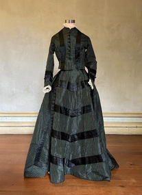
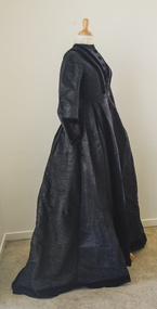
Clothing - Black chalk-striped outfit, 1870
This outfit belonged to Mary Ann Henty [nee Lawrence] (1821-81), the wife of Francis Henty (1815-89). Her husband, Francis Henty, was the youngest son of Thomas Henty, who with his family, their retainers and property moved to the Australian colonies between 1829 and 1832. In 1834, Francis’ older brother, Edward, sailed from Launceston in Van Diemen’s Land to what was to become Portland in the western part of Port Phillip District [Victoria]. Francis, together with the first flock of Merino sheep [in Victoria], followed some months later. The first and second generations of the Henty family established vast pastoral properties in the Western part of the Port Phillip District. Francis Henty managed ‘Merino Downs’ near Casterton, while also living in his retirement at ‘Field Place' in Kew.The Henty Collection of nineteenth and twentieth century clothing, including outerwear and underwear, was collected, stored and exhibited over time by female family members descended from Francis and Mary Ann Henty. During the twentieth century, items from the collection were modelled in two fashion parades by various descendants [1937, 1959]. The items in the collection are historically and aesthetically significant, with provenance provided by oral and written tradition within or held by the family. A number of the items in the collection are very rare survivors, and provide researchers with the evidence needed to reconstruct the lives of notable women in the Port Phillip District [later Victoria] during the nineteenth and early twentieth century.A two-piece silk taffeta chalk-striped afternoon dress worn by Mary Ann Henty, aged 49, in the period when she lived at Merino Downs near Portland. The outfit has bands of black silk and rows of fabric covered buttons on the bodice and skirt. Measurements (mm): BODICE: Girth - Neck 355.6, Chest 889, Waist 736.6, Hip 863.6, Cuff 254, Hem circumference 2032. Vertical - Front neck to hem 419.1, Front waist to hem 152.4, Back neck to hem 558.8, Back waist to hem190.5 , Sleeve length 584.2. Horizontal - Neck to sleeve head 165.1, Chest back 330.2, Underarm to underarm 406.4. SKIRT Girth - Waist 609.6, Hip 1270, Hem circumference 4064. Vertical - Front waist to hem 1117.6, Back waist to hem 1371.6.francis henty, fashion -- 1870s, women's clothing, afternoon dresses, mary ann (lawrence) henty -
 Kew Historical Society Inc
Clothing - Pink silk evening dress, c.1842
This dress is believed to have belonged to Mary Ann Henty [nee Lawrence] (1821-81), the wife of Francis Henty (1815-89). Her husband, Francis Henty, was the youngest son of Thomas Henty, who with his family, their retainers and property moved to the Australian colonies between 1829 and 1832. In 1834, Francis’ older brother, Edward, sailed from Launceston in Van Diemen’s Land to what was to become Portland in the western part of Port Phillip District [Victoria]. Francis, together with the first flock of Merino sheep [in Victoria], followed some months later. The first and second generations of the Henty family established vast pastoral properties in the Western part of the Port Phillip District. Francis Henty managed ‘Merino Downs’ near Casterton, while also living in his retirement at ‘Field Place' in Kew. The Henty Collection of nineteenth and twentieth century clothing, including outerwear and underwear, was collected, stored and exhibited over time by female family members descended from Francis and Mary Ann Henty. During the twentieth century, items from the collection were modelled in two fashion parades by various descendants [1937, 1959]. The items in the collection are historically and aesthetically significant, with provenance provided by oral and written tradition within or held by the family. A number of the items in the collection are very rare survivors, and provide researchers with the evidence needed to reconstruct the lives of notable women in the Port Phillip District [later Victoria] during the nineteenth and early twentieth century.A one-piece, lustrous silk taffeta evening dress, lined with polished cotton, probably owned by Mary Ann Henty, and later by her daughter, Alice. The V-waist line of the dress and the dimensions of the skirt are comparable to Mary Ann’s wedding dress. The bodice in contrast is less structured. At a later stage, the sleeves were removed. Measurements (mm): BODICE: Girth - Neck 914.4, Chest 863.6, Waist 685.8, Hip 863.6, Hem circumference 3302. Vertical - Front neck to hem 1371.6, Front waist to hem 1092.2, Back neck to hem 1384.3, Back waist to hem 1079.5 Horizontal - Neck to sleeve head 44.45, Chest back 431.8, Underarm to underarm 431.8.mary ann lawrence, francis henty, evening dresses, henty collection, fashion -- 1840s -
 Kew Historical Society Inc
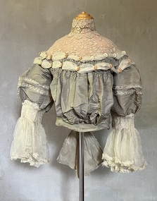
Clothing - Midnight blue silk and velvet bodice
This bodice, belonging to Alice (Henty) Hindson has traditionally been identified as a travelling jacket by her descendants. Alice Hindson was the youngest daughter of Francis Henty and Mary Ann (Lawrence) Henty. Alice's father, Francis Henty, was the youngest son of Thomas Henty, who with his family, their retainers and property moved to the Australian colonies between 1829 and 1832. In 1834, Francis’ older brother, Edward, sailed from Launceston in Van Diemen’s Land to what was to become Portland in the western part of Port Phillip District [Victoria]. Francis, together with the first flock of Merino sheep [in Victoria], followed some months later. The first and second generations of the Henty family established vast pastoral properties in the Western part of the Port Phillip District. Francis Henty managed ‘Merino Downs’ near Casterton, while also living in his retirement at ‘Field Place' in Kew. The Henty Collection of nineteenth and twentieth century clothing, including outerwear and underwear, was collected, stored and exhibited over time by female family members descended from Francis and Mary Ann Henty. During the twentieth century, items from the collection were modelled in two fashion parades by various descendants [1937, 1959]. The items in the collection are historically and aesthetically significant, with provenance provided by oral and written tradition within or held by the family. A number of the items in the collection are very rare survivors, and provide researchers with the evidence needed to reconstruct the lives of notable women in the Port Phillip District [later Victoria] during the nineteenth and early twentieth century.Alice (Henty) Hindson's midnight blue sateen bodice is highlighted using velvet lapels, cuffs, and a rear bow. The velvet, in contrast to the plain midnight blue sateen, is embellished [in the weave] with pink and navy spots. Joined at the front with 23 round domed buttons, hooks and eyes are used to close the neckline. The bodice also features coffee-coloured lace at the front and on the cuffs, which may have been added later. The bodice has some condition issues, missing one cuff and the lace on the cuffs needing re-attaching. The inside of the bodice is heavily boned, complete with a floral chintz lining. Measurements (mm): BODICE: Girth - Neck 355.6, Chest 812.8, Waist 660.4, Hip 685.8, Cuff 228.6 Vertical - From neck to hem 406.4, Front waist to hem 152.4, Back neck to hem 546.1, Back waist to hem 228.6, Sleeve length 533.4. Horizontal - Neck to sleeve head 114.3, Cross back 266.7, Underarm to underarm 368.3.alice hindson, alice henty, bodices, women's clothing, alice (henty) hindson -
 Kew Historical Society Inc
Clothing - Black moiré silk faille day dress, 1880
This dress belonged to Mary Ann Henty [nee Lawrence] (1821-81), the wife of Francis Henty (1815-89). Her husband, Francis Henty, was the youngest son of Thomas Henty, who with his family, their retainers and property moved to the Australian colonies between 1829 and 1832. In 1834, Francis’ older brother, Edward, sailed from Launceston in Van Diemen’s Land to what was to become Portland in the western part of Port Phillip District [Victoria]. Francis, together with the first flock of Merino sheep [in Victoria], followed some months later. The first and second generations of the Henty family established vast pastoral properties in the Western part of the Port Phillip District. Francis Henty managed ‘Merino Downs’ near Casterton, while also living in his retirement at ‘Field Place' in Kew. The Henty Collection of nineteenth and twentieth century clothing, including outerwear and underwear, was collected, stored and exhibited over time by female family members descended from Francis and Mary Ann Henty. During the twentieth century, items from the collection were modelled in two fashion parades by various descendants [1937, 1959]. The items in the collection are historically and aesthetically significant, with provenance provided by oral and written tradition within or held by the family. A number of the items in the collection are very rare survivors, and provide researchers with the evidence needed to reconstruct the lives of notable women in the Port Phillip District [later Victoria] during the nineteenth and early twentieth century.A two-piece, moiré silk faille day dress, owned and worn by Mary Ann Henty, aged 59, while resident at Field Place, Kew. The fitted and panelled bodice on the day dress features wide velvet ribbon, hand sewn to form ‘V’ detailing at front and back. The front bodice hook and eye closure is decorated with handmade velvet covered buttons. The high round neckline is trimmed with pleated ivory fine tulle lace. The wide long sleeves of the bodice are also trimmed with velvet ribbon and buttons forming exquisite cuff detailing. The full length skirt and train are tucked into a fitted waistline band. The hemline is hand finished with wide velvet ribbon. A separate attached peplum is worn over the full bustle of the skirt. Measurements (mm): DRESS: Girth - Neck 355.6, Chest 889, Waist 673.1, Cuff 279.4, Hem circumference 4292.6. Vertical - Front neck to hem 1447.8, Front waist to hem 1117.6, Back neck to hem 1765.3, Back waist to hem 1346.2 , Sleeve length 590.55. Horizontal - Neck to sleeve head 196.85, Chest back 469.9, Underarm to underarm 457.2. PEPLUM Girth - Waist 711.2, Hem circumference 1066.8. Vertical - Back waist to hem 406.4.mary ann lawrence, francis henty, fashion -- 1880s, day dresses, women's clothing -
 Kew Historical Society Inc
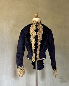
Clothing - Grey silk and lace bodice, 1875
Alice Frances (Henty) Hindson's grey silk bodice is believed to be part of her 'going-away' outfit after her wedding to John Hindson on 15 April 1875. The bodice must have been a family favourite as it was used and amended over the years. Alice was the youngest daughter of Francis Henty and Mary Ann (Lawrence) Henty. Alice's father, Francis Henty, was the youngest son of Thomas Henty, who with his family, their retainers and property moved to the Australian colonies between 1829 and 1832. In 1834, Francis’ older brother, Edward, sailed from Launceston in Van Diemen’s Land to what was to become Portland in the western part of Port Phillip District [Victoria]. Francis, together with the first flock of Merino sheep [in Victoria], followed some months later. The first and second generations of the Henty family established vast pastoral properties in the Western part of the Port Phillip District. Francis Henty managed ‘Merino Downs’ near Casterton, while also living in his retirement at ‘Field Place' in Kew. The Henty Collection of nineteenth and twentieth century clothing, including outerwear and underwear, was collected, stored and exhibited over time by female family members descended from Francis and Mary Ann Henty. During the twentieth century, items from the collection were modelled in two fashion parades by various descendants [1937, 1959]. The items in the collection are historically and aesthetically significant, with provenance provided by oral and written tradition within or held by the family. A number of the items in the collection are very rare survivors, and provide researchers with the evidence needed to reconstruct the lives of notable women in the Port Phillip District [later Victoria] during the nineteenth and early twentieth century.The yoke is a bustier bodice, made of silk and silk organza with an insert of hand-tatted lace. The bodice is carefully boned and has a little padding in the bust line. It includes the name of the maker of the bodice as ‘Madame Jay, Brighton, 38 London Road’. The silk organza sleeves have hand shirring, trim, and frilled cuffs. The bodice is finished with a large, frilled bow at the back. Believed by the Henty family to be part of the ‘going away’ outfit worn by Alice Henty in 1875. Measurements (mm): BODICE: Girth - Neck 304.8, Chest 762, Waist 571.5, Cuff 127 Vertical - From neck to hem 381, Front waist to hem 152.4, Back neck to hem 419.1, Back waist to hem 228.6, Sleeve length 254. Horizontal - Neck to sleeve head 165.1, Cross back 457.2, Underarm to underarm 431.8.Mme Jay, Brighton Road, London [dressmaker]bodices, women's clothing, alice (henty) hindson, alice francés henty -
 Kew Historical Society Inc
Journal, The Kewriosity Sheet Vol.2 No.3 : August 1980
What's doing in Kew for August / p1. Kew Historical Society [George Allan WW2 memorial; Kew Library] / Mavis Rolley p1. St Anne's School - East Kew [50th anniversary of laying of foundation stone] / p1. Epilepsy month / p1. Studley Park Progress Association [Yarra River, Environmental conservation] / Marshall Slattery p2. Greenacres Golf Club / p1. St Hilary's Youth Club / p1. Kintore Social Club / p2. Early landmark of Kew [Kew Court House; Kew Post Office] / Elizabeth Mackie p2. Kew Garden Club / p2. Bowling Club nears century [Kew Bowling Club] / p2.Council News [Kindergarten enrolments; Funds available for local groups; Promoting Kew; Entertainment in Parks; What is R.A.A.V? (Rheumatism and Arthritis Association of Victoria)] / p2. Where have all the people gone? / Rev Stan Simmons p2. Scrabble [Kew Scrabble Club] / p2. Kew & Hawthorn Citizens' Advice Bureau / p2.The Kewriosity Sheet (1979-83) was first published in the City of Kew (Victoria) in June 1979 as a two-sided 'community newssheet'. It aimed to: 'share news about Kew happenings and Kew people, and to exchange ideas about living in Kew'. Later issues gradually evolved into a 4-page, quarto sized publication. The Kewriosity Sheet was superseded by the Kew Council publication 'Kewriosity' (1983-1994).non-fictionWhat's doing in Kew for August / p1. Kew Historical Society [George Allan WW2 memorial; Kew Library] / Mavis Rolley p1. St Anne's School - East Kew [50th anniversary of laying of foundation stone] / p1. Epilepsy month / p1. Studley Park Progress Association [Yarra River, Environmental conservation] / Marshall Slattery p2. Greenacres Golf Club / p1. St Hilary's Youth Club / p1. Kintore Social Club / p2. Early landmark of Kew [Kew Court House; Kew Post Office] / Elizabeth Mackie p2. Kew Garden Club / p2. Bowling Club nears century [Kew Bowling Club] / p2.Council News [Kindergarten enrolments; Funds available for local groups; Promoting Kew; Entertainment in Parks; What is R.A.A.V? (Rheumatism and Arthritis Association of Victoria)] / p2. Where have all the people gone? / Rev Stan Simmons p2. Scrabble [Kew Scrabble Club] / p2. Kew & Hawthorn Citizens' Advice Bureau / p2. community publications --- kew (vic.), the kewriosity sheet, newsletters - kew (vic.) -
 Kew Historical Society Inc
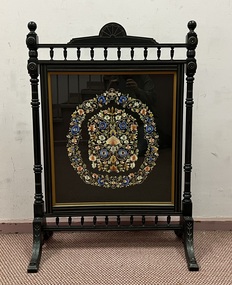
Furniture - Hand embroidered fire screen, 1900-1910
This hand embroidered fire screen was embroidered by Winifred Caroline Henty Hindson (1887–1967), Elsie May Eliza Hindson (1880–1968) and Louisa (Louie) Charlotte Frances Hindson (1885–1963) three of the daughters of Alice Henty and John Hindson. Their grandfather, Francis Henty, was the youngest son of Thomas Henty, who with his family, their retainers and property moved to the Australian colonies between 1829 and 1832. In 1834, Francis’ older brother, Edward, sailed from Launceston in Van Diemen’s Land to what was to become Portland in the western part of Port Phillip District [Victoria]. Francis, together with the first flock of Merino sheep [in Victoria], followed some months later. The first and second generations of the Henty family established vast pastoral properties in the Western part of the Port Phillip District. Francis Henty managed ‘Merino Downs’ near Casterton, while also living in his retirement at ‘Field Place' in Kew.The Henty Collection of nineteenth and twentieth century clothing, including outerwear and underwear, was collected, stored and exhibited over time by female family members descended from Francis and Mary Ann Henty. During the twentieth century, items from the collection were modelled in two fashion parades by various descendants [1937, 1959]. The items in the collection are historically and aesthetically significant, with provenance provided by oral and written tradition within or held by the family. A number of the items in the collection are very rare survivors, and provide researchers with the evidence needed to reconstruct the lives of notable women in the Port Phillip District [later Victoria] during the nineteenth and early twentieth century. Multicoloured silk embroidered floral composition on a black fabric background created by Louisa, Elsie and Winifred Hindson. The embroidery is held behind glass and is protected by blackened wood at the back. The screen is suspended in an ebonized and gilded frame with two rows of spindle decoration. fire screens, women's work, embroidery - 20th century, elsie hindson, louisa hindson, winifred hindson -
Kew Historical Society Inc
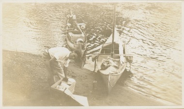
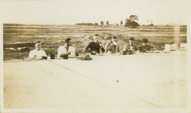
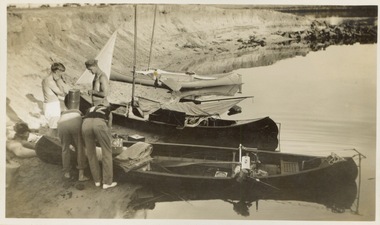
Album - Victorian Canoe Club : Album 2, 1931-5
Canoeing on the River Yarra at Melbourne was an important and widespread recreational pursuit for Melbournians, especially in the first half of the twentieth century. The Victorian Canoe Club was formed in 1912 at a meeting in Melbourne and its first committee elected in the same year. Records indicate that the Club continued into at least the 1950s .The album has historic and social significance as a record of recreational activities in the early years of the twentieth century.Part of an unbound old album, containing photographs of members of the Victorian Canoe Club undertaking a series of trips to the lower and upper Yarra as well as to regional Victoria. All but one of the photographs in the album were labelled by the owner in white ink. The individual photographs in this album are also posted on Victorian Collections separately, typically under the label of the photo in the album. E.g "Salvaging wrecked canoe". Descriptive titles in the album include (sometimes referring to two photos): Xmas 1930, Leaving Studley Park / Breakfast on wharf after camping on lower Yarra / repacking / Old Cerberus / Shooting the rapids, Warrandyte / [Untitled] / Pound Bend tunnel (2) / Old mine / Salvaging wrecked canoe / Mallacoota trip / Gippsland LakesNil apart from individual photo labelsvictorian canoe club, river yarra, kew, warrandyte, upper yarra, lower yarra, cerberus, mallacoota, recreation -- canoeing -
 Kew Historical Society Inc
Photograph - Victorian Canoe Club, Xmas 1930, leaving Studley Park
Canoeing on the River Yarra at Melbourne was an important and widespread recreational pursuit for Melbournians, especially in the first half of the twentieth century. The Victorian Canoe Club was formed in 1912 at a meeting in Melbourne and its first committee elected in the same year. Records indicate that the Club continued into at least the 1950s .The photos in this album are historically and socially significant as a record of recreational activities in the first half of the twentieth century. A number of photographs in the album provide views of sections of the Yarra, as well as areas in regional Victoria, that may otherwise be unavailable.One of 12 sepia [faded] photographs of members of the Victorian Canoe Club. The first photo reveals three of the four club members leaving their clubhouse in Studley Park to travel downstream to the Lower Yarra and beyond to Port Phillip Bay. "Xmas 1930. Leaving Studley Park"victorian canoe club, river yarra, travel -- 1930s, canoeing -
 Kew Historical Society Inc
Photograph - Victorian Canoe Club, Breakfast on wharf after camping on lower Yarra, 1930
Canoeing on the River Yarra at Melbourne was an important and widespread recreational pursuit for Melbournians, especially in the first half of the twentieth century. The Victorian Canoe Club was formed in 1912 at a meeting in Melbourne and its first committee elected in the same year. Records indicate that the Club continued into at least the 1950s .The photos in this album are historically and socially significant as a record of recreational activities in the first half of the twentieth century. A number of photographs in the album provide views of sections of the Yarra, as well as areas in regional Victoria, that may otherwise be unavailable.One of 12 sepia [faded] photographs of members of the Victorian Canoe Club. This photo shows the six club members on the trip eating breakfast on a wharf in a location on the Lower Yarra, before canoeing on to Port Phillip Bay. "Breakfast on wharf after camping on lower Yarra"victorian canoe club, river yarra, travel -- 1930s, canoeing, lower yarra -
 Kew Historical Society Inc
Photograph - Victorian Canoe Club, Repacking, 1930
Canoeing on the River Yarra at Melbourne was an important and widespread recreational pursuit for Melbournians, especially in the first half of the twentieth century. The Victorian Canoe Club was formed in 1912 at a meeting in Melbourne and its first committee elected in the same year. Records indicate that the Club continued into at least the 1950s .The photos in this album are historically and socially significant as a record of recreational activities in the first half of the twentieth century. A number of photographs in the album provide views of sections of the Yarra, as well as areas in regional Victoria, that may otherwise be unavailable.One of 12 sepia [faded] photographs of members of the Victorian Canoe Club. This photo shows four of the club members repacking their canoes on a bank in a location on the Lower Yarra, before canoeing on to Port Phillip Bay. The photo is interesting as it shows that the canoes, which they had constructed, were fitted with sails."Repacking"victorian canoe club, river yarra, travel -- 1930s, canoeing, lower yarra -
 Kew Historical Society Inc
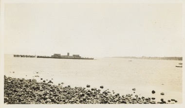
Photograph - Victorian Canoe Club, Old Cerberus, 1930
Canoeing on the River Yarra at Melbourne was an important and widespread recreational pursuit for Melbournians, especially in the first half of the twentieth century. The Victorian Canoe Club was formed in 1912 at a meeting in Melbourne and its first committee elected in the same year. Records indicate that the Club continued into at least the 1950s .The photos in this album are historically and socially significant as a record of recreational activities in the first half of the twentieth century. A number of photographs in the album provide views of sections of the Yarra, as well as areas in regional Victoria, that may otherwise be unavailable.One of 12 sepia [faded] photographs of members of the Victorian Canoe Club. This photo is a distance shot of the HMAS Cerberus, which was sunk at Black Rock, Melbourne in 1926 to act as a breakwater for small craft."Old Cerberus"victorian canoe club, travel -- 1930s, canoeing, hmas cerberus