Showing 11187 items matching "water-supply"
-
 Greensborough Historical Society
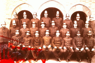
Photograph - Digital Image, Water police 1882-1890, 1882-1890
Digital copy of one of 7 slides depicting photographs of police from 1858 to 1930s. This image is of a group of water police 1882-1890.Digital copy of black and white slide.Caption on original slide 'Water police 1882-1890'victoria police, water police -
 Flagstaff Hill Maritime Museum and Village
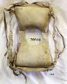
Equipment - Life Jacket, General Naval Supply G.N.S.), 1940
This life jacket was issued by the Australian Government's General Naval Store in N.S.W.. It was inspected in 1940. Life Jackets - Life jackets were part of the equipment carried by the Life Saving Rescue Crew of South Western Victoria, including Warrnambool, from around 1858 until the 1950s. The purpose of a life jacket is to keep the wearer afloat until he or she is rescued from the water. Life jackets were first invented in 1854 by Captain Ward of the Royal National Lifeboat Institution in Britain. The early life jackets were filled with cork, which is very buoyant. However, many times he cork caused the jacket to rise up quickly with a force that caused unconsciousness, sometimes turning the person face down in the water , causing them to drown. After the tragic loss of the ship RMS Titanic in 1912 and the lost lives of those onboard, a woman named Orpheus Newman designed the Salvus life jacket (Salvus means safe), which was filled with kapok instead of cork. Kapok comes from seed pods of the Ceiba Pentandra tree and is waterproof as well as buoyant. These Salvus jackets were used by the Royal Navy until new synthetic materials became available around the time of World War II.This life jacket is significant for its connection with local history, maritime history and marine technology. Lifesaving has been an important part of the services performed from Warrnambool's very early days, supported by State and Local Government, and based on the methods and experience of Great Britain. Hundreds of shipwrecks along the coast are evidence of the rough weather and rugged coastline. Ordinary citizens, the Harbour employees, and the volunteer boat and rescue crew, saved lives in adverse circumstances. Some were recognised as heroes, others went unrecognised. In Lady Bay, Warrnambool, there were around 16 known shipwrecks between 1850 and 1905. Many lives were saved but tragically, eight lives were lost.Life jacket, canvas covered, with two padded compartments filled with kapok. Designed to slip over the head. it has shoulder straps and straps for tying under the arms. An inscription and symbol is stamped on one shoulder strap. The life jacket was supplied by the General Naval Store, Defence Department, N.S.W., and inspected in in 1940.Inscription "G.N.S. [crown symbol] N.S.W / 12 JUN 1940 / INSPECTED".flagstaff hill maritime museum and village, flagstaff hill, maritime museum, maritime village, warrnambool, great ocean road, lady bay, warrnambool harbour, g.n.s., general naval store, 1940s life jacket, captain ward, royal national lifeboat instution, cork, kapok, life jacket, orpheus newman, salvus jacket, life saving, rescue, rescue crew, l.s.r.c., life saving equipment, marine technology, lifeboat, shipwreck victim, vintage -
 Bendigo Historical Society Inc.
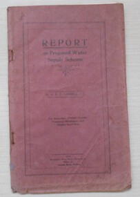
Book - Report on Proposed Water Supply Scheme, 1914
This is a Report of the Sub-Committee of the Peninsula Water Supply Conference on the Mornington Peninsula Water Supply Scheme. It was prepared by A K T Sambell CE. The engineer's report was adopted by the sub-committee in 1914.Report on Proposed Water Supply Scheme. An Engineer's Report on the Mornington Peninsula Water Supply Scheme written by A K T Sambell CE. Burgundy coloured book.42 pp. with black and white photographs. Neville King CollectionThree pages at the back have been used for writing samples written in pencil.water supply, mornington peninsula, a k t sambell -
 Stawell Historical Society Inc
Photograph, Water storage tanks part of reservoir in reefs road -- Coloured
Coloured Photo showing two water storage tanks part of reservoir in reefs roadDirt road in foreground power pole and water tanks. stawell -
Clunes Museum
Document - RECEIPT
RECEIPT FOR WATER SUPPLY TO PREMISES IN SERVICE STREET TO MARCH 31, 1885. ONE POUND --- RECEIVED FROM MR. REV. WM. BROWN. L1.0.0.2 RECEIPTS FROM CLUNES WATER COMMISSIONERS. FOR WATER SUPPLY TO WESLEYAN CHURCH, CLUNES.NO. OF ASSESSMENT 33. JON STEPHENS COLLECTOR.local history, commerce, book keeping, churches - wesley -
 Brighton Historical Society
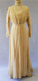
Dress, Professional & Civil Service Supply Association, circa 1900
Unknown provenance.Coffee-coloured cotton and chiffon evening gown. Net yoke with vertical pintucks and high neck. Pintucked bodice. Trim of meadering cream cord bordered on either side, around yoke, waist, shoulders, cuffs and down centre of skirt. Printed on interior of bodice: "Professional & Civil Service Supply Association / 80 George Street Edinburgh".Printed on interior of bodice: "Professional & Civil Service Supply Association / 80 George Street Edinburgh".1900s -
 Tatura Irrigation & Wartime Camps Museum
Photograph, Goulburn Murray Water Yard
Shows picture of Goulburn Murray Water Yard, corner of Ross and William Streets, Tatura. Colour photograph showing Goulburn Murray Water Yard, corner Ross and William Streets, Tatura. Shed and water wheels. Photograph stuck onto piece of white cardboard. goulburn murray water, water wheels -
 Charlton Golden Grains Museum Inc
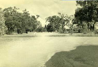
Photograph, Charlton Tribune, 1973 flood at low water bridge
1973 Flood at Charlton, Vic. At the low water bridge.Unframed photograph/ sepia of 1973 flooding of Charlton at low water bridge.flood, low water bridge -
 Yarra Ranges Regional Museum
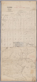
Map, District of Yering, 1 Dec 1885
Canvas backed paper map of District of Yering, Country of Evelyn, showing proposed waterworks for township of Lilydale. Signed by Hodgson & Smith, water supply engineers. Proposed waterworks for the township of Lilydale. Signed by Hodgson & Smith, water supply engineers. Proposed water main shown with of reservoir etc. Canvas backed paper map of District of Yering, Country of Evelyn, showing proposed waterworks for township of Lilydale. Signed by Hodgson & Smith, water supply engineers. Proposed waterworks for the township of Lilydale. Signed by Hodgson & Smith, water supply engineers. Proposed water main shown with of reservoir etc. evelyn, lilydale, waterworks and irrigation -
Tatura Irrigation & Wartime Camps Museum
Photograph, Automatic Waterlevel Recorder, 1957
Taken by photographer for State Rivers and Water Supply Commission.Large, black and white photograph. Round, hollow, concrete pipe supporting platform with water level recorder being operated by Commission worker. Channel filled with water behind equipmentbelow photo: "Automatic Water Level Recorder - Rodney District"victoria state rivers and water supply commission, irrigation, automatic waterlevel recorder -
Ringwood and District Historical Society
Envelope, Packet: State Electricity Commission supply to East Ringwood 1935 and Heathmont 1937
State Electricity Commission letter 1930; Electricity supply to East Ringwood 1935; Electricity supply to Heathmont 1937 -
Stawell Historical Society Inc
Map, T.F. McGauran, William Couty of Borong 1891, 1891
Stawell Water Supply Reserve. Grampians State Forest. Dairy Creek, Fyans Creek, Barney's Creek, Bovine Creek, Glasstree Creek, Stoney Creek. Stawell Water Supply Aquaduct Fkuming Tunnel.A2 Parish Map of Willam Inculdin Stawell Water Supply Reserve and Creeks. Marked in redPhoto Lithographed at the Department of Lands and Survey Melbourne. By T.F. McGauran 20.07.91 water supply survey -
Tatura Irrigation & Wartime Camps Museum
Photograph, Stuart Murray Canal Sign, 1890s
Taken by photographer for State Rivers and Water Supply Commission.Medium sized black and white photograph. Sign:-"STATE RIVERS AND WATER SUPPLY COMMISSION/GOULBURN IRRIGATION SYSTEM/STUART MURRAY CANAL/CONVEYS WATER FROM GOULBURN WEIR TO WARANGA RESERVOIR/DESIGNED AND CONSTRUCTED BY VICTORIAN WATER SUPPLY DEPARTMENT - 1981./STUART MURRAY M.I.C.E CHIEF ENGINEER."goulburn weir, victorian state rivers and supply commission -
 Marysville & District Historical Society
Postcard (Item) - Colour tinted postcard, Murray Views, Murray Views No. 51. The Water Wheel, Marysville, Vic, 1950
A digital copy of a colour tinted postcard of the water wheel that powered the Barton's Store in Marysville in Victoria.A digital copy of a colour tinted postcard of the water wheel that powered the Barton's Store in Marysville in Victoria. This water wheel was located on the Steavenson River in Marysville. Barton's Store was established by Thomas John Barton in 1864. Thomas John Barton was born in 1836 in Gloucestershire and after his father died in 1850 arrived in Melbourne in 1852 along with his mother, adult sisters, younger brothers, his uncle, his uncle's wife Suzanna and their family. Thomas tried gold mining at Woods Point but found it too difficult. He then partnered with Ewen Hugh Cameron to provide the miners with meat. In 1864 they purchased a plot of land in Marysville and set up a butchers/abattoirs and from there began their business of taking supplies to the miners at the nearby Woods Point and Jamieson goldfields. In 1865 the business was firmly established and Thomas married Selina Croker at Heidelberg and brought her back to Marysville. Their first home was 'The Chestnuts', which included the store, and was situated on the town side next to the Steavenson River. Sadly, in 1876 Selina died of complications after giving birth to their sixth child. Thomas was in need of a nanny to care for his six children, including the newborn baby, and so he employed Emily Ada Sparke, who is the eldest daughter of the local school teacher. Thomas and Emily subsequently marry in 1878 and they go on to have a further 10 children over the next several years. Thomas assisted in the establishment of the first school in Marysville in 1870 and remained a very active member of the community including as a Councillor for the Shire of Healesville, Shire President and he was also appointed as a Justice of the Peace. Thomas died in Carlton in 1911. After their father's death, his sons Fred and Frank took over the family business, which was then known as Barton Bros Store which continued to operate until sometime in the 1970's. This postcard was produced by Murray Views in 1950 as a souvenir of Marysville.marysville, victoria, barton's store, thomas john barton, ewen hugh cameron, woods point, jamieson, gold mining, goldfields, selina croker, the chestnuts, emily ada sparke, shire of healesville, fred barton, frank barton, barton bros store, francis adam barton, frederick john barton, water wheel, steavenson river, murray views, murray views no. 51, postcard, souvenir -
 Flagstaff Hill Maritime Museum and Village
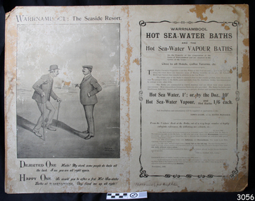
Poster - Recreation, Warrnambool Hot Sea Water Baths, c. November 1908
The poster includes a cartoon by Arthur Jordan, with a conversation between an ailing man and a good man after baths visits. There are several reviews dating from 1906 to 1908 extolling the healing powers of the baths' waters. In February 1877 a Baths Company (1050 shares) was formed in the town of Warrnambool for the establishment of the baths at the south end of Gillies Street. The baths were filled with sea water from Lady Bay, originally pumped by a windmill situated near the current Surf Lifesaving Club and carried by iron pipes to the Public Baths; later the water was pumped by gas motor. Hot and cold fresh water baths were advertised. The gentlemen’s bath was 100 feet long and 50 feet wide, of graduating depth. A second bath, solely for ladies, was 60 feet long by 30 feet wide. Hot Sea-water Baths were also part of the institution, and were sought after for their ‘wonderful curative powers’, and ‘incomparable’ as a ‘tonic for the feeble’. In June 1881 the Hot Sea Baths were opened, and both hot and cold water baths were supplied at reasonable charges. Patrons came from near and far to receive the benefits. The manager of the Baths was J. Kirkpatrick. The Baths Company struggled for several years without success so in 1883 the baths were sold to the Borough Council for 1250 pounds. The original shareholders received nothing for their outlay; the overdraught was over the sale price. In May 1884 the Council announced that an estimated they has spent 1000 pounds in improving the baths since purchasing them and were now returning an income of 11 per cent. The poster promotes the healing powers of the hot sea water baths that were in use in Warrnambool in the late 19th century through to the early 20th century. The baths were a place for fitness, health and social activity, an example of the recreational activities during this period.Poster, black and white, mounted on card. It shows advertising Warrnambool Sea-water Baths and Hot Sea-water Baths. There are several references promoting the health benefits of baths, dating from 1906-1908. The cartoon was sketched by Arthur Jordan. The poster was printed by The Thompson Printing Co. Warrnambool. Handwritten inscription on the lower edge.Handwritten "10,000 mailed by post through Victoria"flagstaff hill, warrnambool, shipwrecked-coast, flagstaff-hill, flagstaff-hill-maritime-museum, maritime-museum, shipwreck-coast, flagstaff-hill-maritime-village, warrnambool salt baths, warrnambool therapudic baths, arthur jordan, baths company, sea water baths, hot sea water, swimming, healing powers, warrnambool baths, advertisement, thompson printing co. warrnambool -
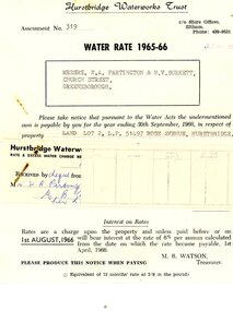 Greensborough Historical Society
Financial record - Account, Hurstbridge Waterworks Trust, Hurstbridge Waterworks Trust water rate assessment 1965-66, 13/05/1965
Hurstbridge Waterworks Trust water rates accounts for land jointly owned by W.A. (Alan) Partington and H.V. (Horrie) Burkett for 2 properties in Hurstbridge (Rose Avenue and Daphne Crescent.Alan Partington and Horrie Burkett had a history of joint property ownership from their early days in Warragul.2 Water rates accounts, black text on white paperHandwritten receipt.alan partington, william alan partington, partington family, horrie burkett, hurstbridge, hurstbridge waterworks trust -
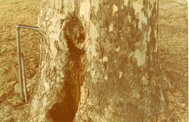 Stawell Historical Society Inc
Photograph, Central Park Tree with Water Tap, C 1960's 2012
Central Park –Tree with Water TapFour (4) Colour Photographs of a tree with a Water pipe embedded in it. One older and smaller than the other three.stawell, central park -
 Tatura Irrigation & Wartime Camps Museum
Photograph, Water Tower Kerford Street Tatura
Shows picture of the original Water Tower, which was situated in Kerford Street, Tatura. Sepia photograph showing the original water tower. Photograph stuck onto piece of white cardboard. tatura victoria, water tower tatura, kerford street tatura -
Whitehorse Historical Society Inc.
Document, Sale Plan 38, 12/09/1855
Parish of Nunawading Sale Plan 38.Parish of Nunawading Sale Plan 38. Description of land is given with water supply. Surveyor C.Hodgkinson.Parish of Nunawading Sale Plan 38. parish of nunawading, hodgkinson, clement, water supply -
Tatura Irrigation & Wartime Camps Museum
Document, History of Irrigation in Goulburn Murray Irrigaton District, 1990
Brief history of irrigation in Goulburn Murray Irrigation district and brief information on headworks supplying water to the area.Black folder, containing papers on State Rivers and Water Supply Commission worksdocument, irrigation -
 Kew Historical Society Inc
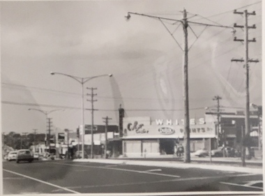
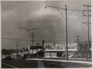
Photograph, Stuart Tompkins Studio, Electricity Supply Poles, Warrigal Road, Ashwood, 1965
Research provided by Stuart Tompkins Studio, Box Hill, into alternatives for median strip street lighting to be used in Burke Road, Kew. The photographers identified variants in different suburbs appropriate to Kew's needs.The series from which the photograph is drawn provides a snapshot by a commercial photographic studio of each named vicinity in 1965 as well as providing examples of public works infrastructure being commissioned by local government in the 1960s. The photos originally formed part of the Engineering Department's files in the City of Kew before being donated to the kew Historical Society.Electricity Supply Poles, Warrigal Road, Ashwood, 1965. Stuart Tompkins Studio provided this photograph for the Kew City Council. The photograph, taken at the intersection of Warrigal Road and High Street South, Ashwood looks north along High Street Road. The intent of the photograph was to provide the Council with models of electricity supply poles. In the photo, wooden and steel poles can be seen in the median strip. The photograph also includes the shops bordering High Street Road during this period. [There are three copies of this photograph in the Collection.]. Typed inscription on reverse: "Electricity Supply Poles. Photographed for Kew City Council 8/2/65. No.4 Warrigal Road - Ashwood. South of High Street Road looking north. Wooden and steel poles with different brackets in median strip." Studio stamp: "Stuart Tompkins Studio. 547 Station Street, Box Hill. WX1439."electric light poles, public works -- 1960s, civic infrastructure -- 1960s -
 Kew Historical Society Inc
Photograph, Stuart Tompkins Studio, Electricity Supply Poles, Warrigal Road, Ashwood, 1965
Research provided by Stuart Tompkins Studio, Box Hill, into alternatives for median strip street lighting to be used in Burke Road, Kew. The photographers identified variants in different suburbs appropriate to Kew's needs.The series from which the photograph is drawn provides a snapshot by a commercial photographic studio of each named vicinity in 1965 as well as providing examples of public works infrastructure being commissioned by local government in the 1960s. The photos originally formed part of the Engineering Department's files in the City of Kew before being donated to the kew Historical Society.Electricity Supply Poles, Warrigal Road, Ashwood, 1965. Stuart Tompkins Studio provided this photograph for the Kew City Council. The photograph, taken at the intersection of Warrigal Road and High Street South, Ashwood looks north along High Street Road. The intent of the photograph was to provide the Council with models of electricity supply poles. In the photo, wooden and steel poles can be seen in the median strip. The photograph also includes the shops bordering High Street Road during this period. [There are three copies of this photograph in the Collection.]. Typed inscription on reverse: "Electricity Supply Poles. Photographed for Kew City Council 8/2/65. No.4 Warrigal Road - Ashwood. South of High Street Road looking north. Wooden and steel poles with different brackets in median strip." Studio stamp: "Stuart Tompkins Studio. 547 Station Street, Box Hill. WX1439."electric light poles, civic infrastructure - 1960s, public works -- 1960s -
 Kew Historical Society Inc
Photograph, Stuart Tompkins Studio, Electricity Supply Poles, Warrigal Road, Ashwood, 1965
Research provided by Stuart Tompkins Studio, Box Hill, into alternatives for median strip street lighting to be used in Burke Road, Kew. The photographers identified variants in different suburbs appropriate to Kew's needs.The series from which the photograph is drawn provides a snapshot by a commercial photographic studio of each named vicinity in 1965 as well as providing examples of public works infrastructure being commissioned by local government in the 1960s. The photos originally formed part of the Engineering Department's files in the City of Kew before being donated to the kew Historical Society.Electricity Supply Poles, Warrigal Road, Ashwood, 1965. Stuart Tompkins Studio provided this photograph for the Kew City Council. The photograph, taken at the intersection of Warrigal Road and High Street South, Ashwood looks north along High Street Road. The intent of the photograph was to provide the Council with models of electricity supply poles. In the photo, wooden and steel poles can be seen in the median strip. The photograph also includes the shops bordering High Street Road during this period. [There are three copies of this photograph in the Collection.]. Typed inscription on reverse: "Electricity Supply Poles. Photographed for Kew City Council 8/2/65. No.4 Warrigal Road - Ashwood. South of High Street Road looking north. Wooden and steel poles with different brackets in median strip." Studio stamp: "Stuart Tompkins Studio. 547 Station Street, Box Hill. WX1439."electric light poles, public infrastructure -- 1960s, civic works -- 1960s -
Tatura Irrigation & Wartime Camps Museum
Folder, Water Conference and Deputation to the Premier 1885, 1885
Water conference and deputation to the Premier asking to assist the Goulburn Valley to construct a weirLarge black folder containing submissions to the Premier, Mr. Service, requesting funds to build water storagesvictorian water supply, book, history, local -
Clunes Museum
Document - REPORT, RURAL WATER COMMISSION OF VICTORIA, DEVELOPMENT OF PROPOSALS FOR REGIONAL MANAGEMENT - DISCUSSION PAPER SEPTEMBER 1985, 1985
FOREWORD: EARLIER THIS YEAR A PROJCT TEAM WAS ESTABLISHED TO DEVELOP PROPOSALS FOR REGIONAL MANAGEMENT OF THE COMMISSION'S ACTIVITIES....1 SPIRAL BOUND, PALE GREEN FRONT COVER OUTLINING THE DISCUSSION PAPER - REPORT BY RURAL WATER COMMISSION OF VICTORIA 1985 .2 LETTER TO MR H TOOLE FROM THE RURAL WATER COMMISSION DATED 19 SEPTEMBER 1985FOREWORD: EARLIER THIS YEAR A PROJCT TEAM WAS ESTABLISHED TO DEVELOP PROPOSALS FOR REGIONAL MANAGEMENT OF THE COMMISSION'S ACTIVITIES...local history, document, report, water supply -
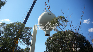 Eltham District Historical Society Inc
Photograph, Demolition of water tower at 51 Cassells Road, Research, 6 April 2017, 6/4/2017
"The water storage tank (the ‘golf ball’ tower) was located in Cassells Road, and for many years it played an important role in supplying the Research and Eltham communities with drinking water. However, due to prior upgrades of water supply infrastructure in the area, these communities are receiving their water supply in a more reliable way. The storage tank was no longer operating and as it no longer served a purpose, the time had come for it to be removed. Decommissioning works occurred between November 2016 and January 2017, and the tower was removed in March 2017." Source: Yarra Valley Water Eltham Water Project onlineDigital files only (17 jpg and one two second MP4 files)cassells road, demolition, research (vic.), water tower -
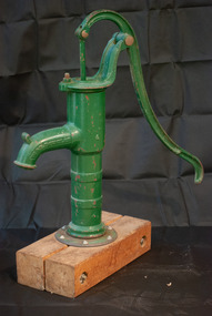 Nillumbik Historical Society Incorporated
Functional object - Hand Pump, W & B Douglas Pump Factory, Hand Pump to Manually Draw Water from Well, Mid - Late 19th Century
Hand Pump. Reticulated water did not reach Diamond Creek until 1914. This beautiflly restored hand pump raised water from the outside domed well to provide cool clear water for domestic use.The Hand Pump is a well preserved example of equipment used domestically in the Diamond Creek areaHand pump used for pumping water from shallow wells. Restored by Kim Howard in 1996. Green. Column is screwed to base which is mounted on Redgum planks.PATENTED 1842, W & B DOUGLAS, "MIDD'A CONN.#handpump, #waterpump, #domesticuse -
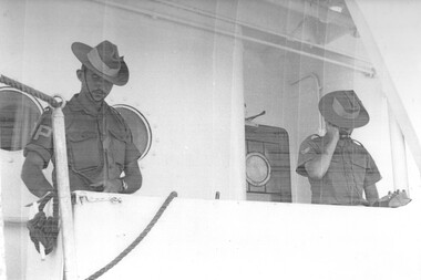 National Vietnam Veterans Museum (NVVM)
Photograph, Gibbons, Denis, Naval Supply Vessel Security
Denis Gibbons (1937 – 2011) Trained with the Australian Army, before travelling to Vietnam in January 1966, Denis stayed with the 1st Australian Task Force in Nui Dat working as a photographer. For almost five years Gibbons toured with nine Australian infantry battalions, posting compelling war images from within many combat zones before being flown out in late November 1970 after sustaining injuries. The images held within the National Vietnam Veterans Museum make up the Gibbons Collection. A black and white photograph - One of the many duties carried out by the Australian Military Police at Vung Tau was the security and protection of the two Australian Naval Supply vessels, The MV Boonaroo & MV Jeparit, whilst on this duty the MP's had to look out for attack from water and land.photograph, vung tau, military police, supply ship, hmas boonaroo, hmas jeparit, gibbons collection catalogue, australian naval supply vessels, mp's, denis gibbons -
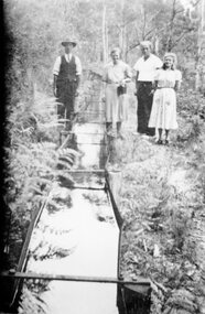 Stawell Historical Society Inc
Photograph, Stawell Water Supply's Open Fluming c1948
Open Fluming Stawell Water Supply c1948stawell -
 Tatura Irrigation & Wartime Camps Museum
Photograph, Goulburn Murray Water Tatura
Shows picture of the premises of Goulburn Murray Water, Casey Street, Tatura. Colour photograph showing the premises of Goulburn Murray Water, Casey Street, Tatura. Photograph stuck onto piece of white cardboard. tatura victoria, tatura businesses, goulburn murray water