Showing 3404 items matching " 2000.522..01"
-
 St Kilda Historical Society
Photograph - Photo map, 30/01/1960
One of a series of photo-maps produced for the Department of Crown Lands and Survey (1857-1983). For correlation with a current map, and access to other historical photo maps of Victoria, see the Historic Photo-Maps Index published by the Department of Environment, Land, Water and Planning at https://services.land.vic.gov.au/DELWPmaps/historical-photomaps/Black and white aerial photographVic 1091-2 Melbourne & Metropolitan Project Run 24East 30.1.60 Lens 10" 8.200elwood, elwood park, elwood beach, elsternwick park, 1960 -
 St Kilda Historical Society
Photograph - Photo map, 11/01/1968
One of a series of photo-maps produced for the Department of Crown Lands and Survey (1857-1983). For correlation with a current map, and access to other historical photo maps of Victoria, see the Historic Photo-Maps Index published by the Department of Environment, Land, Water and Planning at https://services.land.vic.gov.au/DELWPmaps/historical-photomaps/Black and white aerial photographVic 2132 State Aerial Survey Melbourne 1968 Proj Run 27E 11.1.68 5100 ASL 65caulfield north, caulfield park, armadale, malvern, 1968 -
 St Kilda Historical Society
Photograph - Photo map, 11/01/1968
One of a series of photo-maps produced for the Department of Crown Lands and Survey (1857-1983). For correlation with a current map, and access to other historical photo maps of Victoria, see the Historic Photo-Maps Index published by the Department of Environment, Land, Water and Planning at https://services.land.vic.gov.au/DELWPmaps/historical-photomaps/Black and white aerial photographVic 2132 State Aerial Survey Melbourne 1968 Proj Run 27E 11.1.68 5100 ASL 67st kilda east, st kilda cemetery, caulfield north, alma park, balaclava, armadale, 1968 -
 St Kilda Historical Society
Photograph - Photo map, 13/01/1968
One of a series of photo-maps produced for the Department of Crown Lands and Survey (1857-1983). For correlation with a current map, and access to other historical photo maps of Victoria, see the Historic Photo-Maps Index published by the Department of Environment, Land, Water and Planning at https://services.land.vic.gov.au/DELWPmaps/historical-photomaps/Black and white aerial photograph2138 State Aerial Survey Melbourne 1968 Proj. Run 26 13.1.68 5100 ASL 203st kilda west, albert park, fawkner park, south yarra, prahran, windsor, 1968 -
 St Kilda Historical Society
Photograph - Photo map, 11/01/1968
One of a series of photo-maps produced for the Department of Crown Lands and Survey (1857-1983). For correlation with a current map, and access to other historical photo maps of Victoria, see the Historic Photo-Maps Index published by the Department of Environment, Land, Water and Planning at https://services.land.vic.gov.au/DELWPmaps/historical-photomaps/Black and white aerial photographVic 2132 State Aerial Survey Melbourne 1968 Proj. Run 27E 11.1.68 5100 ASL 69st kilda, albert park, st kilda east, st kilda beach, alma park, windsor, prahran, 1968 -
 St Kilda Historical Society
Photograph - Photo map, 11/01/1968
One of a series of photo-maps produced for the Department of Crown Lands and Survey (1857-1983). For correlation with a current map, and access to other historical photo maps of Victoria, see the Historic Photo-Maps Index published by the Department of Environment, Land, Water and Planning at https://services.land.vic.gov.au/DELWPmaps/historical-photomaps/Black and white aerial photographVic 2132 State Aerial Survey Melbourne 1968 Proj. Run 28E 11.1.68 5100 ASL 81st kilda, balaclava, st kilda east, ripponlea, elwood, elsternwick, caulfield, st kilda botanical gardens, 1968 -
 St Kilda Historical Society
Photograph - Photo map, 11/01/1968
One of a series of photo-maps produced for the Department of Crown Lands and Survey (1857-1983). For correlation with a current map, and access to other historical photo maps of Victoria, see the Historic Photo-Maps Index published by the Department of Environment, Land, Water and Planning at https://services.land.vic.gov.au/DELWPmaps/historical-photomaps/Black and white aerial photographVic 2132 State Aerial Survey Melbourne 1968 Proj. Run 29E 11.1.68 5100 ASL 194elwood, elwood beach, elwood park, elsternwick park, ripponlea, elwood canal, balaclava, st kilda, 1968 -
 St Kilda Historical Society
Photograph - Photo map, 11/01/1968
One of a series of photo-maps produced for the Department of Crown Lands and Survey (1857-1983). For correlation with a current map, and access to other historical photo maps of Victoria, see the Historic Photo-Maps Index published by the Department of Environment, Land, Water and Planning at https://services.land.vic.gov.au/DELWPmaps/historical-photomaps/Black and white aerial photographVic 2132 State Aerial Survey Melbourne 1968 Proj. Run 27E 11.1.68 5100 ASLst kilda, st kilda west, st kilda pier, catani gardens, st kilda beach, albert park, 1968 -
 St Kilda Historical Society
Photograph - Photo map, 11/01/1968
One of a series of photo-maps produced for the Department of Crown Lands and Survey (1857-1983). For correlation with a current map, and access to other historical photo maps of Victoria, see the Historic Photo-Maps Index published by the Department of Environment, Land, Water and Planning at https://services.land.vic.gov.au/DELWPmaps/historical-photomaps/Black and white aerial photographVic 2132 State Aerial Survey Melbourne 1968 Proj. Run 29E 11.1.68 5100 ASL 196elwood, elwood park, elwood canal, elwood beach, st kilda marina, mc moran reserve, point ormond, 1968 -
 St Kilda Historical Society
Photograph - Photo map, Department of Crown Lands and Survey (1857-1983), 22/01/1970
One of a series of photo-maps produced for the Department of Crown Lands and Survey (1857-1983). For correlation with a current map, and access to other historical photo maps of Victoria, see the Historic Photo-Maps Index published by the Department of Environment, Land, Water and Planning at https://services.land.vic.gov.au/DELWPmaps/historical-photomaps/Black and white aerial photographVic 2358 Department of Crown Lands and Survey Victoria,.© Melbourne 1970 Project Run 41E 22.1.70 5,100 ASL 62caulfield, caulfield north, st kilda east, armadale, 1970 -
 St Kilda Historical Society
Photograph - Photo map, Department of Crown Lands and Survey (1857-1983), 22/01/1970
One of a series of photo-maps produced for the Department of Crown Lands and Survey (1857-1983). For correlation with a current map, and access to other historical photo maps of Victoria, see the Historic Photo-Maps Index published by the Department of Environment, Land, Water and Planning at https://services.land.vic.gov.au/DELWPmaps/historical-photomaps/Black and white aerial photographVic 2358 Department of Crown Lands and Survey Victoria,.© Melbourne 1970 Project Run 42E 22.1.70 5,100 ASL 77st kilda, st kilda east, st kilda marina, elwood, elwood canal, elsternwick park, point ormond, balaclava, mc moran reserve, ripponlea, st kilda botanical gardens, peanut farm, 1970 -
 St Kilda Historical Society
Photograph - Photo map, Department of Crown Lands and Survey, 22/01/1970
One of a series of photo-maps produced for the Department of Crown Lands and Survey (1857-1983). For correlation with a current map, and access to other historical photo maps of Victoria, see the Historic Photo-Maps Index published by the Department of Environment, Land, Water and Planning at https://services.land.vic.gov.au/DELWPmaps/historical-photomaps/Black and white aerial photographVic 2358 Department of Crown Lands and Survey Victoria,.© Melbourne 1970 Project Run 43E 22.1.70 5,100 ASL 208elwood, elwood beach, point ormond, elwood park, elwood canal, mc moran reserve, 1970 -
 St Kilda Historical Society
Photograph - Photo map, Department of Crown Lands and Survey, 22/01/1970
One of a series of photo-maps produced for the Department of Crown Lands and Survey (1857-1983). For correlation with a current map, and access to other historical photo maps of Victoria, see the Historic Photo-Maps Index published by the Department of Environment, Land, Water and Planning at https://services.land.vic.gov.au/DELWPmaps/historical-photomaps/Black and white aerial photographCONTROLLED Vic 2358 Department of Crown Lands and Survey Victoria,.© Melbourne 1970 Project Run 41E 22.1.70 5,100 ASL 66st kilda, albert park, st kilda west, catani gardens, st kilda botanical gardens, st kilda pier, st kilda beach, 1970 -
 St Kilda Historical Society
Photograph - Photo map, Department of Crown Lands and Survey, 22/01/1970
One of a series of photo-maps produced for the Department of Crown Lands and Survey (1857-1983). For correlation with a current map, and access to other historical photo maps of Victoria, see the Historic Photo-Maps Index published by the Department of Environment, Land, Water and Planning at https://services.land.vic.gov.au/DELWPmaps/historical-photomaps/Black and white aerial photographVic 2358 Department of Crown Lands and Survey Victoria,.© Melbourne 1970 Project Run 42E 22.1.70 5,100 ASL 75st kilda, st kilda beach, st kilda marina, point ormond, st kilda pier, 1970 -
 St Kilda Historical Society
Photograph - Photo map, Department of Crown Lands and Survey, 22/01/1970
One of a series of photo-maps produced for the Department of Crown Lands and Survey (1857-1983). For correlation with a current map, and access to other historical photo maps of Victoria, see the Historic Photo-Maps Index published by the Department of Environment, Land, Water and Planning at https://services.land.vic.gov.au/DELWPmaps/historical-photomaps/Black and white aerial photographVic 2358 Department of Crown Lands and Survey Victoria,.© Melbourne 1970 Project Run 41E 22.1.70 5,100 ASL 64st kilda, st kilda cemetery, balaclava, st kilda east, windsor, caulfield north, alma park, 1970 -
 St Kilda Historical Society
Photograph - Photo map, Department of Crown Lands and Survey, 08/01/1970
One of a series of photo-maps produced for the Department of Crown Lands and Survey (1857-1983). For correlation with a current map, and access to other historical photo maps of Victoria, see the Historic Photo-Maps Index published by the Department of Environment, Land, Water and Planning at https://services.land.vic.gov.au/DELWPmaps/historical-photomaps/Black and white arial photographVic 2345 Department of Crown Lands and Survey Victoria,.© Melbourne 1970 Project Run 40 8.1.70 5,100 ASL 77albert park, fawkner park, south yarra, middle park, prahran, windsor, st kilda, st kilda west, 1970 -
 St Kilda Historical Society
Photograph - Photo map, 22/01/1970
One of a series of photo-maps produced for the Department of Crown Lands and Survey (1857-1983). For correlation with a current map, and access to other historical photo maps of Victoria, see the Historic Photo-Maps Index published by the Department of Environment, Land, Water and Planning at https://services.land.vic.gov.au/DELWPmaps/historical-photomaps/Black and white aerial photographVic 2358 Department of Crown Lands and Survey Victoria,.© Melbourne 1970 Project Run 43E 22.1.70 5,100 ASL 206elwood, elsternwick, elsternwick park, 1970 -
 St Kilda Historical Society
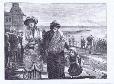
Photograph - Lithograph, The Argus, The St Kilda Baths, 28/01/1882
Printed on p. 29; foreground shows two women in period dress with a young girl black and white lithograph, unmounted, copy, fair condition[printed on front] Coming from the St. Kilda Baths. 1882 -
 Tatura Irrigation & Wartime Camps Museum
Audio Tape, State Rivers and Water Supply Commission 75th Anniversary, 1981/05/01
Tape made of the quarterly senior staff meeting to commemorate the 75th anniversary of the State RIvers and Water Supply Commission - 1st May 1981, speakers - W.E Bromfield, L.J Greenhill, F.C O'Connor, A.L. Tisdall, Sir Ronald East.S.R. & W.S.C 75th Anniversary 1st May 1981irrigation, victoria state rivers and water supply commission, bromfield, greenhill, o'connor, tisdall, sir ronald east -
Tatura Irrigation & Wartime Camps Museum
Folio, Tatura Mechanics Institute, Jun-01
Mechanics Institute Hall opened 1881 was Tatura's first public buildingPhotographic and photocopiedrecords of archival materials covering development 1881-1972, 1977-1983victory hall, documents, reports -
Tatura Irrigation & Wartime Camps Museum
Folio, Newspaper clippings, Mar-01
Collected and collated from Murchison Advertiser newspapers by John WeppnerCollection of newspapercuttings/articles from Murchison Advertiserlocal history, documents, newspapers -
 Anglesea and District Historical Society
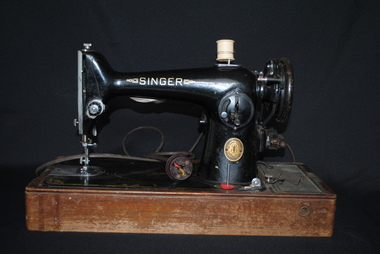
Singer Sewing Machine (Black), 23/01/1952
Class/Model: 15K. One hundred thousand made between 1890-1957. From Serial No. EH23584 we know the class and model No. How many were made and the date of manufacture. The 15K was used for domestic and industrial sewing. Threads left to right and has a vertical oscillating shuttle.EH 13584. Top: SINGER MANUFACTURING CO (gold) - with wooden base. Side: SINGER. LIGHT - SINGER. Back: SINGER SEWING MOTOR. 230-250 VOLTS 03 AMPS / 25-75 CYC's AC-DC / CAT NO. BRK12-5 /NO. K7003527.singer, sewing machine -
Tatura Irrigation & Wartime Camps Museum
Document, Tatura Collage Columns Time Capsule Contents, 26/01/2000
Envelope contains a list of the Tatura Collage Columns and Time Capsule Contents which were presented to The City of Greater Shepparton on Australia Day 26/1/2000Yellow Foolscap size envelope contains a list and map of the Tatura Collage Columns together with a list of the contents of the time capsules held in 9 of the columns."Time Capsule Contents" in top left hand corner of envelope|Tatura Collage Columns" "Lake Bartlett Walk" "Columns Park Walk" in centre of envelope|Australia Day 26th January 2000 AD - 2050 AD RSL 2025 along bottom edge of envelope| Australian flag sticker stuck in bottom left hand corner of envelopetatura, tatura collage columns, time capsule, lake bartlett, australia day committee, column park walk, gail baumber, rodney shire, documents, reports -
 Uniting Church Archives - Synod of Victoria
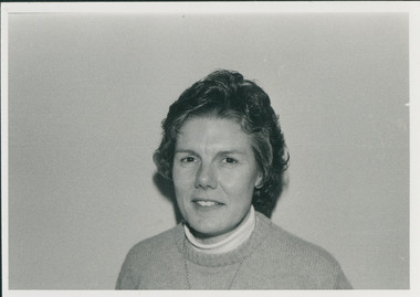
Photograph, Anne amos, 01/1985
Anne Amos retired 2010.Head and shoulder photographs of Anne Amos.Identification of the persons.amos, anne -
 Hume City Civic Collection
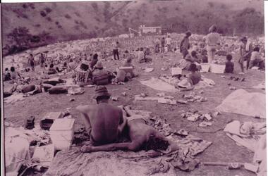
Photograph, 1/01/1972
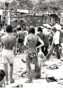
Three pop festivals were staged in Sunbury. One in 1972 and a further ones in 1974 and 1975 . The 1972 festival was the most famous and followed on in the Woodstock tradition. The festivals were staged on a property on the banks of the Jacksons Creek, owned by the Duncan family. A crowd of partly clad people sitting or lying on the ground in a wide valley listening to a performance can be seen in the image. The area is litterred with cans, eskies, blankets, sleeping bags and tents. A stage is in the background.A photograph of the 1972 Sunbury Pop Festival.sunbury pop festival, jacksons creek, duncan, george, george evans collection -
 Hume City Civic Collection
Photograph, 1/01/1971
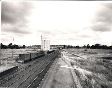
The photograph was taken when railway land on either side of the tracks was used for recreational purposes and agricultural related activities. The local sports ground is on the RHS of the photograph and was used to stage a number of the town's events.A black and white photograph of a section of the two railway platforms and three sets of rail tracks with a stone bridge in the distance. Four rail carriages and eight goods trucks are on a railway siding near a wheat silo. There is open land on either side of the rail tracks.sunbury railway station, wheat silos, railways, macedon street rail bridge., george evans collection -
 Hume City Civic Collection
Photograph, 1/01/1971
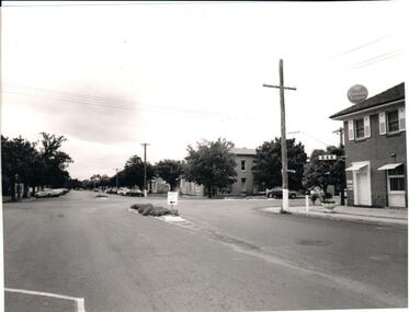
The photograph was taken before the Rupertswood Hotel was demolished to make way for modern shops and before Evans Street became the busiest street in Sunbury CBD.A black and white photograph of the intersection of Evans and Brook Streets. A hotel is on the RHS of the photograph and two small median strips are on either side of the intersection in Evans Street.evans street, brook street, streetscapes, hotels, rupertswood hotel, royal hotel, george evans collection -
 Hume City Civic Collection
Photograph, 1/01/1994
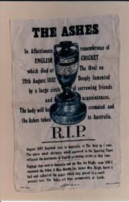
In January 1994 a cricket match was staged at RupertswoodOval between an Australian team and a visiting English team. The match took place to commemorate the staging of a cricket match which took place at Rupertswood in 1882 where a cricket bail was burnt.A coloured photograph of a poster which proclaimed the "Origin of The Ashes" legend.rupertswood, the ashes, birthplace of the ashes, george evans collection -
 Hume City Civic Collection
Photograph, 1/01/1974
This is a photograph of some of the audience standing in front of the stage at the Sunbury Pop Festival in 1974.A black and white photograph of a group of people standing in front of a stage. There is litter on the ground and tents have been pitched on the hillside in the background. Unmounted.sunbury pop festival, music, shire of bulla, duncan, george, o'keefe, johnny, odessa promotions pty. ltd., george evans collection -
 Hume City Civic Collection
Photograph, 1/01/1988
A coloured photograph of two members of the Rupertswood Battery holding an Australian flag prior to it being raised. Two other members are looking on while a crowd of people are seated in the background.australia day, village green, rupertswood battery, george evans collection