Showing 11018 items matching " land"
-
 Bendigo Historical Society Inc.
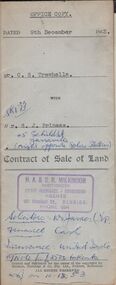
Document - H.A. & S.R. WILKINSON COLLECTION: CONDITION OF SALE
Contract of sale of land dated 9th December 1953 between Mr. C.S. Trewhella (seller) and Mr. S.J. Prineas (buyer) for land being part of Crown allotment 5 section 32 borough of Eaglehawk described in Certificate of title volume 7060 folio 912 and situate 1 Richards Street Eaglehawk, together with brick veneer dwelling and all sundry. Price 3,450 pounds.organization, business, h.a. & s.r wilkinson real estate -
 Bendigo Historical Society Inc.
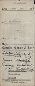
Document - H.A. & S.R. WILKINSON COLLECTION: CONDITION OF SALE
Contract of sale of land dated 10th June, 1954 between Mrs H. Edgecumbe (seller) and Mrs A.L. Pye (buyer) for land part of Crown allotment thirteen AB and twenty section K described in certificate of title volume 5223 folio 518, together with all buildings and erections thereon also all linos, blinds and electric fittings and shades. Price 1900 poundsorganization, business, h.a. & s.r wilkinson real estate -
 Bendigo Historical Society Inc.
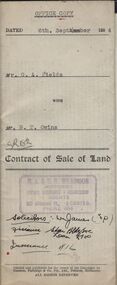
Document - H.A. & S.R. WILKINSON COLLECTION: CONDITION OF SALE
Contract of sale of land dated 6th September 1954 between Mr G.A. Fields (seller) and Mr. B.T. Owins (buyer) for land being part of allotment 7 section L, Long Gully colored red on the map hereof and being described in Indenture of Conveyance No.422 Book 610 and situate in Inglewood Street Bendigo, together with fencing thereon. Price 130 pounds.organization, business, h.a. & s.r wilkinson real estate -
 Bendigo Historical Society Inc.
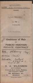
Document - H.A. & S.R. WILKINSON COLLECTION: CONDITION OF SALE
Conditions of sale by private contract dated 28th February, 1946 between N.J.M. Walker (seller) and N.S.Roberts (buyer) for land situate at 59 Norfolk Street, Bendigo having a frontage of 198 links to Norfolk Street by a depth of 250 links land described in right to occupy residence area No. 5105, together with 5-roomed weatherboard dwelling and all sundry. Price 450 pounds.organization, business, h.a. & s.r wilkinson real estate -
 Bendigo Historical Society Inc.
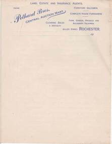
Document - PETHARD COLLECTION: LETTERHEAD - PETHARD BROTHERS, LAND , ESTATE AND INSURANCE AGENTS , ROCHESTER
LETTERHEAD - PETHARD BROTHERS, LAND , ESTATE AND INSURANCE AGENTS , ROCHESTER Five pages of letterhead writing paper. The letterhead is printed in Blue Ink and contains the following words 'Phone', 'Pethard Bros', Central Auction Mart, 'Land Estate and Insurance Agents, 'Furniture Salesmen', 'Complete House Furnishes',' Clearing sales a speciality', 'farm, garden, 'Produce and Machinery Salesmen', 'Gillies Street, Rochester'.Pethard Bros. Central Auction Mart, Rochester.cottage, miners -
 Clunes Museum
Document - LAND LICENCE
.1 LICENCES FOR DEPARTMENT OF LANDS AND SURVEY - OCCUPATION BRANCH. LICENCE NO 315892 TO 315901. 25 FEBRUARY 1901 TO FEBRUARY 1902 STAPLED TOGETHER .2 LAND ACT 1869 SEC 20 BOOK 88. ON SPINE "THE CROWN - LAND ACT1869. SEC 20. 88 RECEIPTS FROM REVENUE OFFICE NO 2 TO 118 RECEIPTS 119 TO 249 HAVE NOT BEEN USED, THEY ARE CUT IN HALF.2 WHITE ROUND STICKER WITH "5" ON FRONTdepartment of lands and survey, land act 1869, occupation branch, revenue office -
 Thompson's Foundry Band Inc. (Castlemaine)
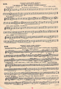
Document - Sheet Music, Boosey & Co Ltd, Hosannah & Selection of other tunes, 1912
This item is a set of music produced by Boosey and Hawkes and arranged by James Ord Hume.Sheet music containing music for 16 tunes including: Hosanna, Judge me, O God, Land of Hope and Glory, Rejoyce Today, The Lost Chord, Hymn of the Home-Land, Two Chorales by Bach, Hymns of the Great Composers, Baden, Saxony, Kyris Eleison, Como, Silver Moonlight Winds are Blowing, Oh Who will o'er the downs so free, and Softly Falls the MoonlightfictionThis item is a set of music produced by Boosey and Hawkes and arranged by James Ord Hume.sheet music, hymn, euphonium solo, cornet solo, quick march, grand chorus -
 Bendigo Historical Society Inc.
Document - MISS G ALICE JONES COLLECTION: ACCOUNT
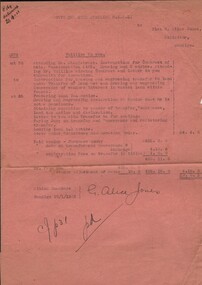
South New Chum Syncline G.M.N.L. to Miss G. Alice Jones. Pink paper dated Oct 20 to Oct 25, 1932, and 18/1/1933. Re Phillips to you. Account is for work involved in the Contract of Sale, Transfer of Land, preparing and lodging Land Tax notice and costs under Solicitors Remuneration Order. Cost £9.0.3. R569 delivered LB 18.1.33.the miss g alice jones collection - account, south new chum syncline g.m.n.l., mr stanistreet, mr phillips -
 Bendigo Historical Society Inc.
Document - MISS G ALICE JONES COLLECTION: ACCOUNT
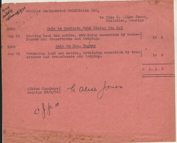
Bendigo Amalgamated Goldfields Ltd. To Miss G. Alice Jones. Re Sale to Carlisle Gold Mining Co. N.L. and Sale to Mrs. Hughes. Pink paper dated Aug 18, 1925, Jan 21, 1926, and 29/6/26. Account is for transfer of land and of land tax. "R414 posted by? 29/6/26" written in top left corner. Cost£1.1.0.the miss g alice jones collection - account, bendigo amalgamatyed goldfields ltd, carlisle gold mining co n.l., mrs hughes -
 Bendigo Historical Society Inc.
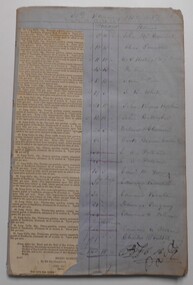
Document - LANDS OFFICE: SANDHURST AND DISTRICT LAND SALES BY PUBLIC AUCTION 1857, 1857 - 58
Document: blue lined pages listing crown land auctions held in Sandhurst 1857/58. Book contains newspaper cutting listing town lots for sale. LH page: Total, balance, deposit, purchaser. LH page: same. White sticker fixed to front: Book 6 Sandhurst land Sales including outlying areas 30 January 1857 to 29 June 1859bendigo, land sales -
 Kew Historical Society Inc
Plan - Subdivision Plan, J R Mathers & McMillan, Glenferrie Road, Cotham Road, Belmont Avenue, Stirling Street, 1910-1930
Pru Sanderson, in her groundbreaking ‘City of Kew Urban Conservation Study : Volume 2 - Development History’ (1988), summarised the periods of urban development and subdivisions of land in Kew. The periods that she identified included 1845-1880, 1880-1893, 1893-1921, 1921-1933, 1933-1943, and Post-War Development. These periods were selected as they represented periods of rapid growth or decline in urban development. An obvious starting point for Sanderson’s groupings involved population growth and the associated economic cycles. These cycles also highlighted urban expansion onto land that was predominantly rural, although in other cases it represented the decline and breakup of large estates. A number of the plans in the Kew Historical Society’s collection can also be found in other collections, such as those of the State Library of Victoria and the Boroondara Library Service. A number are however unique to the collection.The Kew Historical Society collection includes almost 100 subdivision plans pertaining to suburbs of the City of Melbourne. Most of these are of Kew, Kew East or Studley Park, although a smaller number are plans of Camberwell, Deepdene, Balwyn and Hawthorn. It is believed that the majority of the plans were gifted to the Society by persons connected with the real estate firm - J. R. Mathers and McMillan, 136 Cotham Road, Kew. The Plans in the collection are rarely in pristine form, being working plans on which the agent would write notes and record lots sold and the prices of these. The subdivision plans are historically significant examples of the growth of urban Melbourne from the beginning of the 20th Century up until the 1980s. A number of the plans are double-sided and often include a photograph on the reverse. A number of the latter are by noted photographers such as J.E. Barnes.A ‘proposed’ subdivision of the area in the vicinity of Cotham and Glenferrie Roads and Belmont Avenue depicts an alternate vision for how the land might be divided into lots. When comparing this undated proposed subdivision with a modern map, it is possible to see why the subdivision did not eventuate. The right-of-way shown in the plan as beginning in Belmont Avenue was to be extended much further, preventing the lower lots from being created in the proposed shapes. Identifying the date of the name change may assist in the dating of the proposed subdivision. In faded writing at the top of the plan is an annotation referring to ‘Abbotsford’ and Finlayson’s Agency.subdivision plans - kew, glenferrie road, cotham road, belmont avenue, stirling street -
Glenelg Shire Council Cultural Collection
Photograph, Photograph Reclamation and Canal Work, 1959
Port of Portland Authority ArchivesFront: General view: Aerial view West showing wharf and canal areas. November 1959 - typed.port of portland -
Glenelg Shire Council Cultural Collection
Photograph, Photograph - Reclamation and Canal Work, 1959
Port of Portland Authority ArchivesBack: 1959 - black biroport of portland -
Glenelg Shire Council Cultural Collection
Photograph - Photograph - Queen Elizabeth II and Prince Phillip, 1970, 1970
From the Glenelg Shire Council records. The royal visit took place in 1970. The Queen and Prince Phillip visited Portland.Black and white photo. Queen Elizabeth II and Prince Phillip being driven in open land rover, past crowd of school children at Hanlon Park, Portlandroyal visit, queen elizabeth ii, prince phillip, 1970 -
Glenelg Shire Council Cultural Collection
Photograph - Photograph - Aerial photograph of coastline around Portland, Victoria, c. 1954
Black and white aerial photograph of coastline around Portland. Black border, scale all sides, 5 rows of 3 't' at regular intervals. Mostly landFront: '607 - 52 ' - handwritten, white, border 'RUN 7 ' 'PORTLAND', printed, white, border -
Glenelg Shire Council Cultural Collection
Photograph - Photograph - aerial view of Portland, c. 1954
Black and white aerial photograph of coastline around Portland. Black border, scale all sides, 5 rows of 3 't' at regular intervals. Mostly landFront: '607 - 53 ' - handwritten, white, border 'RUN 7 ' 'PORTLAND', printed, white, borderaerial photography, central portland, portland harbour, south west coastline -
 Kiewa Valley Historical Society
Black and White photograph of Road Making Machinery, Kiewa Road Making 25/08/1938 No. 2, 25/08/1938
Construction of the main road from South Tawonga to the Bogong High Plains, to provide access to the construction sites for the new Kiewa Hydro Electric Scheme, was commenced early in 1938, the work being undertaken on behalf of the commission by the Country Roads Board. For the construction work, the Commission purchased three Caterpillar - model R07 - diesel crawler tractors equipped with Kay Brunerei (Brunner) hydraulically operated trailbuilders (angle dozers). This acquisition resulted from a visit to the United States of America in May, 1937 by the Construction Engineer ( Mr. C.H. Kernot) and Assistant Civil Engineer ( Mr. J.F. Douglas) where they saw this relatively new type of equipment in use. With the co-operation of the CRB, the Commission demonstrated the operation of these machines at Fishermen's Bend on 6th April, 1938. They were then sent to Kiewa where they commenced operation towards the end of the month. From South Tawonga, the route let immediately across the Western Branch of the Kiewa River necessitating the construction of a bridge 100 feet long. By the end of 1939, the excavation had been 'opened up' for a distance of 19 1/2 miles (approx. 31 km.) and of this length, 10 miles (approx. 16 km.) had been surfaced. (see KVHS 0328)The purchase of this type of mechanical equipment in road making was a huge investment, as prior to this most of the work would have been done manually with the use of picks and shovels. Not only were many months of hard manual labour saved, but a very significant amount of time in providing access to the proposed work sites for the new Kiewa Hydro Scheme. This photo is an excellent reminder of how primitive the early machinery was compared to the present but also represents the forward thinking of the State Electricity Commissions engineers in purchasing such innovative equipment.A black and white photograph of road making near Mt. Beauty in 1938. Mount Beauty hills can be seen in the background with cleared land for grazing in the fore ground.Hand printed in black ink at the top of the photograph is 'Kiewa Road Making 25/8/1938'. On the right hand corner has been printed the number 2. It has been printed on gloss Velox paper.road making, state electricity commission, caterpillar tractor, kiewa, secv -
Glenelg Shire Council Cultural Collection
Photograph - Photograph - Main Breakwater Construction, n.d
Port of Portland Authority Archivesport of portland archives, portland harbour, reclaimed land, battery point -
Glenelg Shire Council Cultural Collection
Photograph - Photograph - Portland Harbour, Main Breakwater Construction, n.d
Port of Portland Authority Archivesport of portland archives, harbour construction, wharf, battery point -
 Bendigo Historical Society Inc.
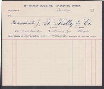
Document - CAMBRIDGE PRESS COLLECTION: ACCOUNT - J. F. KELLY
Account page from J F Kelly & Co, House Land and Estate Agents. Date line ends 193-. Printed in light and dark blue and red.business, printers, cambridge press, cambridge press collection, j f kelly & co, j f kelly, f j byrne, city mutual fire insurance company limited -
Port Melbourne Historical & Preservation Society
Photograph - Port Melbourne foreshore behind the piers prior to redevelopment, Dec 1992
Nine colour, wide angle photographs of the Port Melbourne foreshore and adjacent land behind Station and Princes Piers before the high-rise development, Dec 1992piers and wharves - princes pier, natural environment, transport - railways -
 National Vietnam Veterans Museum (NVVM)
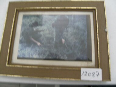
Photograph, Mine Detection
Photograph of 2 soldiers in jungle greens sweeping for land mines. 1 solider is drouching with an SLR. The other solider carries a mine sweeper and is wearing head phonesphotograph, mine sweeping, slr -
 Whitehorse Historical Society Inc.
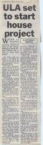
Article, ULA set to start house project, 6/10/1992 12:00:00 AM
Article on the development of 'Banksia Estate',Article on the development of 'Banksia Estate', former site of Blackburn South Primary School, Branksome Grove, by the Urban Land Authority. In Nunawading Gazette, 6 October 1992.Article on the development of 'Banksia Estate', banksia estate, victoria. urban land authority, blackburn south primary school, no. 4035, xeriscope, water supply, canterbury road, blackburn south, branksome grove, land subdivision -
 Whitehorse Historical Society Inc.
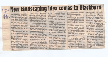
Article, New landscaping idea comes to Blackburn, 4/10/1992 12:00:00 AM
Article on the development of 'Banksia Estate',Article on the development of 'Banksia Estate', former site of the Blackburn South Primary School, Branksome Grove, by the Urban Land Authority. In Nunawading Post, 4 October 1992.Article on the development of 'Banksia Estate',banksia estate, victoria. urban land authority, blackburn south primary school, no. 4035, xeriscope, water supply, canterbury road, blackburn south, branksome grove, land subdivision -
 Whitehorse Historical Society Inc.
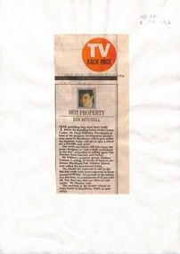
Newspaper - Article, Hot property, 1/09/1994
Sale of 32 blocks of land on former Blackburn East Primary School site, now known as Greenwood Estate. Expected purchase range between $80,000 and $100,000.williams, lloyd, fletcher and parker, hudson conway property group, blackburn east primary school, no. 4800, vicki street, blackburn south -
Whitehorse Historical Society Inc.
Map, Nunawading Planning Scheme, 7/06/1994 12:00:00 AM
Local Section maps 1 - 4 with index. Geographical information system land Information Branch. Scale 1:10,000 Shows zoning under planning scheme.Local Section maps 1 - 4 with index. Geographical information system land Information Branch. Scale 1:10,000 Shows zoning under planning scheme.Local Section maps 1 - 4 with index. Geographical information system land Information Branch. Scale 1:10,000 Shows zoning under planning scheme.blackburn, blackburn north, blackburn south, forest hill, heatherdale, maps, nunawading, vermont, vermont south, town planning, burwood east, laburnum -
Whitehorse Historical Society Inc.
Article, Sites for training scheme, 1993
Vacant land in Nunawading should be used for an employment training scheme to help long term unemployed.Vacant land in Nunawading should be used for an employment training scheme to help long term unemployed. Council wants to know what the community thinks about the idea.Vacant land in Nunawading should be used for an employment training scheme to help long term unemployed.youth, shambrook, tim, gardiner, bob -
Whitehorse Historical Society Inc.
Map, VR Box Hill - Blackburn, 1953
Maps of proposed station at Laburnum on Box Hill to Blackburn railway lines, by Victorian Railways, showing boundaries of Victorian Railways land and the proposed boundaries for Laburnum Station.Maps of proposed station at Laburnum on Box Hill to Blackburn railway lines, by Victorian Railways, showing boundaries of Victorian Railways land and the proposed boundaries for Laburnum Station.Maps of proposed station at Laburnum on Box Hill to Blackburn railway lines, by Victorian Railways, showing boundaries of Victorian Railways land and the proposed boundaries for Laburnum Station.laburnum railway station, laburnum street, blackburn, victorian railways -
Whitehorse Historical Society Inc.
Document, Property report, 1987
Property Report: Land at cnr. of Burwood Highway and Station Street BurwoodProperty Report: Land at cnr. of Burwood Highway and Station Street Burwood. For sale by tender on behalf of the Royal Victorian Institute for the Blind. Agent: Baillieu Knight Frank.Property Report: Land at cnr. of Burwood Highway and Station Street Burwoodburwood highway box hill south, station street box hill south, royal victorian institute for the blind, baillieu knight frank -
 Whitehorse Historical Society Inc.
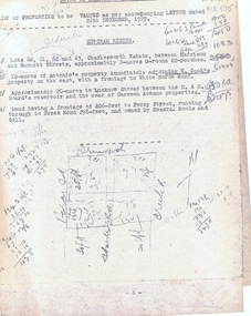
Legal record - Correspondence, Valuation of properties, 24/12/1929 12:00:00 AM
List of property valuations for Mitcham Riding of the Shire of Blackburn and Mitcham dated 24 / 12 / 1929.List of property valuations for Mitcham Riding of the Shire of Blackburn and Mitcham dated 24 / 12 / 1929. Valued by C. Morton of land that was being considered for parks in 1930.List of property valuations for Mitcham Riding of the Shire of Blackburn and Mitcham dated 24 / 12 / 1929. mitcham riding, mitcham road, shire of blackburn and mitcham, land values, charlesworth estate, mitcham, harrison street, burnett street, antonio, cook, w, whitehorse road, lucknow street, creek road, rooks, gell, percy street