Showing 10721 items
matching sites
-
 Bendigo Historical Society Inc.
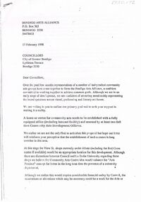
Document - MERLE HALL COLLECTION: LETTER FROM THE BENDIGO ARTS ALLLIANCE TO COGB COUNCILLORS FEB 1998
Letter from the Bendigo Arts Alliance to CoGB Councillors 17 Feb 1998 re request for support for a Centre for community arts,its office and two full-time staff. Reference to the availability of the View Street site and Fortuna. Signed Sue Prain, Chair. -
 Bendigo Historical Society Inc.
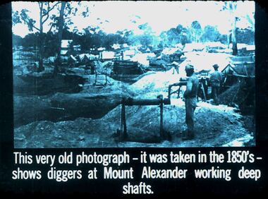
Slide - DIGGERS & MINING. GETTING THE GOLD, c1850s
Diggers & Mining. Getting the Gold. Slide: This very old photograph - it was taken in the 1850s shows diggers at Mount Alexander working deep shafts. Photo shows how close the mining sites were. Markings: 41 994.LIF:4. Used as a teaching aid.hanimounteducation, tertiary, goldfields -
 Kew Historical Society Inc
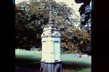
Slide - Queen Victoria Jubilee Fountain, Alexandra Gardens, 1979
One of a group of slides taken by members of the Society of built heritage in Kew in 1979-80. The selection of subject matter reflects the priorities of the period. The colour of some slides has degraded.The slides represent a snapshot in time of built architecture in Kew, much of which has changed in the forty-plus period since they were created.Colour positive transparency (slide) of the Queen Victoria Jubilee Fountain in the Alexandra Gardens, Cotham Road. The fountain was previously sited in front of the Kew Post Office but was relocated to the gardens in the 1920s when the Kew War Memorial was being constructed. The latter required the resting of the fountain. alexandra gardens -- kew (vic.), queen victoria jubilee fountain, queen victoria jubilee, monuments -- kew (vic.) -
 University of Melbourne, Burnley Campus Archives
Plan - Photocopy, Burnley Gardens New Plant Research Laboratory, 1960
Sheet 1 of 8Photocopy, reduced in size, of original plan. Signed by Chief Architect, Dept of Public Works, Victoria. Site plan for new Plant Research Laboratory beside Existing Laboratory, dated ?.04.60, UCB.2.170. University of Melbourne - Property and Services has a better copy.plant research, laboratories -
 City of Greater Bendigo - Civic Collection
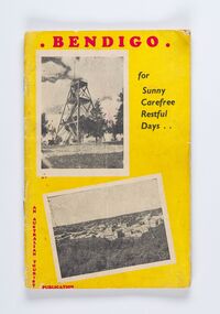
Booklet, Co-operative Press, Bendigo for Sunny Carefree Restful Days, 1947
A promotional publication to attract and encourage tourism to the district. Includes information about geographic location, climate and attractions. Businesses advertising is very eclectic and includes fashion houses, breweries, cafes and the School of Mines and Industry.Thirty six booklet promoting popular sites, events and businesses in Bendigo. Printed in three colour. Right hand page has the slogan BENDIGO "For That Dreamed - of Holiday" with images and text. Left page has full and half page advertisements for businesses, buildings and events.Bendigo / For / Sunny / Carefree / Restful / Days .../ An Australian Tourist / Publicationcity of greater bendigo commerce, city of greater bendigo events, city of greater bendigo tourism, making a nation -
Port Melbourne Historical & Preservation Society
Audio - PMHPS Meeting, Avenues of Honour, Dr Laura James, John Kirby et al, 27 Jul 2015
PMHPS monthly meeting 27.07.2015 Dr Laura James discussing Avenues of Honour created in towns and cities following World War I, and relating stories of sevice men and women commemorated at various sites. Duration 1:04:59 (including meeting preliminaries)war - world war i, dr laura james, avenues of honour -
 Ringwood and District Historical Society
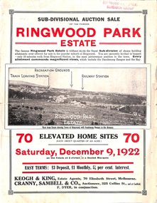
Flyer, Sub-divisional auction sale advertisement - Ringwood Park Estate, Ringwood, Vic. - 1922
Folded double-sided page with black and white photographs of local views with black and red print advertising auction sale on Saturday 9th December, 1922, - 70 residential home sites, including terms of sale, locality map, and description of local facilities and services. Subdivision includes Wonga Road (later Loughnan Road), William Street, Andrew Street, and Harrison Street. Vendors Solicitors - Rigby & Fielding, 60 Market Street, Melbourne. Estate Agents - Keogh & King, 70 Elizabeth Street, Melbourne, Telephone 6938. Auctioneer - Cranny, Sambell & Co., 325 Collins Street, Melbourne, Telephone Central 5067 and 5077. -
 Falls Creek Historical Society
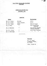
Letter - Information Bulletin No.4 September 1961
Bob (Herman) Hymans (a former member of the Royal Netherlands Navy) was born in Bloemendaal, Holland on 30th September 1922. During World War II he fought against the Japanese in the Dutch East Indies (now Indonesia) and was imprisoned in Changi and on the Burma Railway. After gaining qualifications as a Ski Instructor, Bob arrived in Falls Creek in July 1950. Working as an Instructor and Supervisor at Bogong Lodge, Bob decided his future was in accommodation. He was successful in negotiating an indenture for land from the State Electricity Commission (SEC). It took Bob two years to build his Grand Coeur Chalet but, tragically, it was burned down in August 1961. Bob also built the first Chairlift in Australia. This was a single chairlift and the structure was built from wooden electricity poles. He was constantly full of new ideas and proposals for the village. Bob Hymans died on 7th July 2007. This Collection of documents and letters tells the story of Bob's endeavours to develop Falls Creek into the ski village it is today.This letter is significant because it documents developments made or endorsed by the Falls Creek Tourist Area Management Committee.A 4 page bulletin released by the Management Committee explaining changes to rental charges for the future. It also makes reference to the development of a masterplan for the Falls Creek Tourist Area. Acknowledgement of the loss of Grand Coeur Chalet is made and that Mr Hymans intends to rebuild on the same site.falls creek tourist area management committee, information bulletin -
 Kew Historical Society Inc
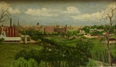
Painting - Panoramic View of Kew and Abbotsford from the garden of Rockingham, V Maloney, 1952
The extensive formal landscaped gardens of Rockingham had been created in the 1860s, and by the 1950s remained bordered to the south by the Barkers Road cutting, and to the north by Blytheswood, the neighbouring Syme family property, By 1940, the Syme family were no longer the occupiers of Rockingham. John Herbert Syme had died in October 1939, and by August the following year, his wife had made the house and garden available, rent free to the Red Cross as a convalescent home for Australian soldiers injured in the Second World War. At the time, the house was described as containing twenty rooms, including a ballroom and a billiards room, with a garden of eight acres overlooking the Yarra. The task of renovating the house to conform to its new function as a convalescent home took a year, finally opening in August 1941. Community support for Rockingham was widespread and included the decision by the National Gallery of Victoria to loan pictures from its collection to decorate the walls. Calls were made for women around Victoria to donate fruit and vegetables from their gardens, which the railways agreed to freight for free. Other local support included the work by a team of boys to establish a three-acre vegetable garden within the formal terraced gardens. From the beginning, occupational therapy formed a key component of the rehabilitation of psychologically injured soldiers. This is confirmed by contemporary newspaper accounts of weaving, ironwork, leatherwork, basketry and gardening by patients. Numerous photographs, held by the Australian War Memorial (AWM) and the State Library of Victoria (SLV), record the importance of these rehabilitation activities. The painting of the view across the river to Abbotsford may have been painted in one of these occupational therapy sessions. For many decades it hung in the occupational therapy room. It must have been on view following the sale of Rockingham by the Syme family to the Red Cross in 1955, and subsequently, until the house was demolished and its grounds finally subdivided in 1977.View of Abbotsford from the garden of Rockingham (1952) was created by V Maloney. The vantage point of the artist was the garden of Rockingham, one of two mansions overlooking the Yarra owned by the Syme family. The artwork depicts a number of sites - especially factories - that have since been demolished.Signed by the artist, lower right "V Maloney"rockingham red cross convalescent home, hospitals - kew (vic), rosemary lade, art therapy -
 Lakes Entrance Historical Society
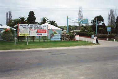
Photograph, Holding M, Whiters Camp Park, 1994c
Colour photograph of Whiters Holiday Village, Whiters Street, Lakes Entrance, Victoria, developed on the site that was known as Whiters Camp Park. Shows the entry to the complex between stone fences, advertising boards on fence line, glimpse of cottages and mature trees inside the grounds.tourism, resort, caravan parks -
 Phillip Island and District Historical Society Inc.
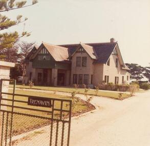
Photographs, John Cook, 1978-79
Trenavin Park was built by Mr Sambell on a site just above the original site of the McHaffie homestead. Was owned by Mr & Mrs Oswin (70's)Six coloured photographs of Trenavin Park, Ventnor, Phillip Island. 81-90: Front view of Trenavin Park 81-90a: Back view of Trenavin Park 81-90b: Interior of Trenavin Park showing stairs 81-90c: Interior of Trenavin Park showing lounge and dining areas 81-90d: Interior of Trenavin Park showing games room with billiard table 81-90e: The Furneryphotographs, trenavin park phillip island, john cook -
 Greensborough Historical Society
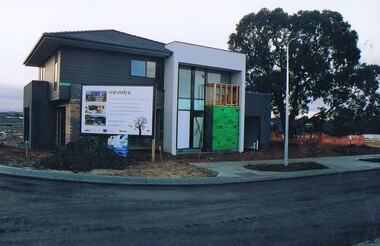
Photograph - Digital image, Frank Solomon, First dwelling in the One Evelyn Way development, 2010c
First home built on the One Evelyn Way development in Greensborough This site was previously a pig farm and there were some environmental concerns as this site was developed.Digital copy of colour photographone evelyn way greensborough -
![Photograph - Digital image, Greenbriar Nursery [Greensborough], 02/05/2013](/media/collectors/4f729f5697f83e03086015b8/items/5729ba9e2162f108e8de4df7/item-media/5729bad92162f108e8de534e/item-fit-380x285.jpg) Greensborough Historical Society
Greensborough Historical SocietyPhotograph - Digital image, Greenbriar Nursery [Greensborough], 02/05/2013
These photographs of the Greenbriar Nursery site were taken in 2013 to show changes over 40 years, based on Ron Reynold’s sketches in the 1973 publication “Greensborough and Greenhills” published by Cypress Books. Although the site now has a house on it, the Nursery drive is still visible. This site is in Mountainview Road.Digital copy of colour photograph.greensborough and greenhills, mountainview road briar hill, greenbriar nursery, ron reynolds -
 Ringwood and District Historical Society
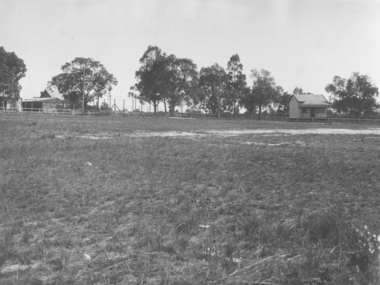
Photograph, Ringwood Oval, Ringwood Street - circa 1918, 1918
Ringwood Oval circa 1920, showing Ringwood Reserve grand stand, tennis courts on the left, and view towards Ringwood Street and Charter Street in the centre backgroun.. The school master's house behind courts was formerly in the Heatherdale Road school in 1885. It was moved in 1892. (See history of Ringwood State School No. 2997).Typed below photograph, "The old Ringwood Reserve grand stand. Tennis courts on the left, looking towards Ringwood and Charter St. in the centre background. ... 1920. (Site) later developed as Eastland carpark, south-west corner." -
 Ringwood and District Historical Society
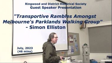
Mixed media - Video, RDHS Guest Speaker Presentation - "Rambles Amongst Melbourne's Parklands Walking Group" - Simon Elliston
Digitised video (2.52GB) Duration: 46 minutes. Recorded July, 2023 (Video is available for viewing at Ringwood & District Historical Society Archives by appointment)Presenter: Simon Elliston talks about his walking group visits to historic sites around Victoria, including an overview of Wombolano Park in Heathmont, once visited by acclaimed celebrities such as Dame Nellie Melba and Agatha Christie. -
 Greensborough Historical Society
Photograph - Digital image, Hooper (nee Roy), 1930c
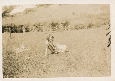
This photograph shows a member of the Roy/Hooper family sitting in the grass in the gully behind Main Street. This is now the site of Watermarc (previously Greensborough Pool site).Digital copy of black and white photograph.hooper family, roy family, greensborough pool, watermarc -
Federation University Historical Collection
Booklet, Ballarat School of Mines, Ballarat School Of Mines Agenda for meeting with Chairman of the TAFE Board, 07/1985
Yellow covered A$ booklet bound with plastic. The book as in agenda for a meeting with I. Predl, acting Chairman of the TAFE Board. Items for discussion were: * L.F.J. Hillman Recreation Building * Maintenance of Buildings * Campus titles and future development * Quality Improvements * College Management Study * Uncertainties Re Blackburn The booklet also includes an aerial photograph of the Ballarat School of Mines campus, including dates each building was erected. The image shows the site of the newly demolished Ballarat Gao, and still has a tennis court and Mining laboratory onsite. The book also show allotment plans of the Ballarat School of Mines site. -
 Bendigo Historical Society Inc.
Newspaper - JENNY FOLEY COLLECTION: HAPPY CAMPERS
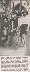
Bendigo Advertiser '' The way we were''from 2002. Happy campers: Girl Guides at Somers Hill near One Tree Hill, circa 1937. From left: Beryl Brown, Mary Runnalls, Elaine Emmerson, Audrey Young. The Girl Guides had a stone hut taken from the site on a piece of land donated by the Keck family. It was situated beside the race between Keck's nursery and One Tree Hill. The site was named Somers Hill after Lady Somers, the chief commissioner of the Girl Guides, and the wife of the Governor of Victoria. Vandals completely destroyed the building in the 70s. The clip is in a folder.newspaper, bendigo advertiser, the way we were -
 Bendigo Historical Society Inc.
Plan - MCCOLL, RANKIN AND STANISTREET COLLECTION: PLAN OF SURVEY OF DAM SITE, 1941
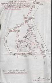
McColl Rankin & Stanistreet, Plan of Survey of Dam site, Part of Crown Allotment 98 Section C, City of Bendigo, Parish of Sandhurst, County of Bendigo. Signed by Garnet G Birch 1 Feb 1941. 33.5 x 43. Attached is a Copy of Field notes, Dam Site in Crown Allotment 198 Sec. City of Bendigo, Parish of Sandhurst. True Meridian, County of Bendigo, Area 0A 1R 16P. Signed Garnet G Birch, 1/2/1941. Drawn in red and black pen. 20.8 x 33. Both maps are for Deborah Extended Gold Mining Co. No Liabilityorganization, mining, deborah extended gold mining co nl, mccoll rankin & stanistreet, plan of survey of dam site -
 Ballarat Tramway Museum
Photograph - Colour Photograph/s, Carolyn Dean, 29/01/2000 12:00:00 AM
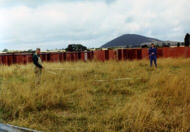
Set of seven colour photographs of initial work in the construction of the off site storage buildings at Bungaree. Taken by Carolyn Dean on 29/1/2000 and 30/1/2000. On Kodak paper. .1 > .3 on 29/1, rest 30/1 1347.1 - John Phillips and Alastair Reither setting out the foundations pegs. .2 - Foundation pegs in. .3 - ditto .4 - Mowing the grass (jungle) - John Phillips and Jim Parker. .5 - the sheep watching the grass go. .6 - the site from the south end. .7 - ditto from the north end.` See Fares Please! March 2000.All have on rear in black ink "29.1.00 or 30.1.00 / Photo by Carolyn Dean"bungaree, storage, btm -
 Ballarat Tramway Museum
Newspaper, The Courier Ballarat, "Housing plan for tram depot site", 19/06/1972 12:00:00 AM
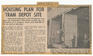
Newspaper clipping from The Courier, Ballarat, dated Monday, June 19, 1972 titled "Housing plan for tram depot site". Reports on the sale of the former tram depot on Saturday June 17 for $54,500. The purchaser expected to start development of housing on the site within three months. Reports on the sale, purchaser and SEC's views. Features a photo of Edgar Bartrop reading the contract. Others in the photo are Bruce Bartrop, SEC Estate officer, Mr. R. Morrison and SEC Manager Mr. I. F. Pellas. One of a large group of newspaper cuttings from John Bainbridge, 7/4/02.depot, buildings, auctions, bartrop -
 Wodonga & District Historical Society Inc
Album - Hume Reservoir Australia Album - Excavations for foundations inside coffer dam, January 1927
This set of photos is from a leather bound album bearing the inscription "HUME RESERVOIR AUSTRALIA" plus 'The Rt. Hon. L. C. M. S. Amery, P. C., M .P.' all inscribed in gold. It was presented to The Rt. Hon. L. C. M. S. Amery, P. C., M. P, Secretary of State for Dominion Affairs on the occasion of his visit to the Hume Reservoir on 2nd November 1927. This album is of local and national significance as it documents the planning and development of the Hume Reservoir up to 1927. It was the largest water reservoir in the British Empire. The album records the pioneering engineering work that went into its construction.DEPARTMENT OF PUBLIC WORKS, N.S.W. RIVER MURRAY WATERS SCHEME. HUME RESERVOIR. 21. Excavations for foundations inside coffer dam. New South Wales. January 1927. Cofferdams are temporary structures used where construction is being carried out in areas submerged in water. They are most commonly used to facilitate the construction or repair of dams, piers and bridges. To divert the river, a Coffer Dam was built across the old bed above and below the Dam site and tying into the end of the concrete wall built inside the levee bank. This completely surrounded the remainder of the site of the Dam and south wing wall, including an area of 12½ acres. hume reservoir australia, river murray waters scheme, hume reservoir construction, coffer dam -
 Bendigo Historical Society Inc.
Photograph - LA TROBE UNIVERSITY BENDIGO COLLECTION: BENDIGO TEACHERS' COLLEGE
BHS CollectionA long white envelope which contained four photos relating to Bendigo Teachers' College in the 1940's and 1950's. It has writing in grey lead giving information on each photo. A black and white photograph of the prefabs on the Bendigo Teachers' College Camp Hill site in the 1950's A black and white photo of The Bendigo Teachers' College site taken from the Look Out Tower in the park. Two black and white photographs of three staff members at Bendigo Teachers' College in 1945 - Mr. M. Morris, Ms. J.C. Burnett and Mr. George Mills (Principal). 2 separate photos.bendigo, education, bendigo teachers' college students, la trobe university bendigo collection, collection, bendigo teachers' college, staff, photo, photographs, photograph, person, individual, male, female, bendigo, education, building, envelope -
Federation University Historical Collection
Document, Lake Bolac Camp Site
A report on the Lake Bolac Primary School as a school camp by Tony Gough and directed to Graham Beanland and Peter Shiells. The Ballarat School of Mines were looking for a camp site for the school bordering a State Forest. Also includes a comment by Colin McCurry of the Physical Education Department. lake bolac, school camp, colin mccurry, tony gough, graham beanland, peter shiells, pam davies -
 Bendigo Military Museum
Weapon - ROCKET LAUNCHER, post 1960
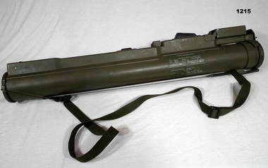
M72 LAW 66mm Rocket Launcher Anti Tank Cylinder Housing. Round cylinder with a 2 clip on end caps adjustable sites & trigger mechanism rubber. All metal construction, has a fabric shoulder strap. Firing instructions drawn in white on one side.Rocket HE 66 mm Anti Tank M72 A3 Lot RAN90 E 001 - 018, Operating and Storage Temp 40oF to + 140oF - Danger near blast area.arms-ordnance, military history, m 72, rocket -
 Ringwood and District Historical Society
Photograph, Ringwood State School schoolmaster's residence. 1945
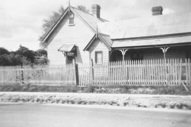
The residence was relocated from school number 2242 in Heatherdale Road (Mitcham) south of the railway line to this site in Ringwood Street opposite Charter Street where it adjoined the school when it opened at the corner of Maroondah Highway in 1889. For Rear View of the residence see record 6855Written below photograph, "Old schoolmasters residence - Ringwood St. - 1945". Written on back of one of smaller copies, "Was used as a residence by Mr. D. Broben(?) H.? No2977 for many years. Photo taken by Miss Joyce Russell for J. K. McCaskill. Bedford Rd." -
 Bendigo Historical Society Inc.
Document - DOCUMENTS RELATING TO: A POSSIBLE SITE FOR A MUSEUM / GALLERY ' 27.10.2005
Documents relating to 'A possible site for a Museum / Gallery ' 27.10.2005 from Kevin J Colvin to Mr Jim Evans / two copies 1 x a4 sheets stapled and 1 x a4 sheets bound in a plastic cover, 32 View St Bendigo was nominated.document, museum / gallery 32 view st bendigo -
 Bendigo Historical Society Inc.
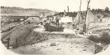
Photograph - MINERS AT VICTORIA REEF, c.1857
Black and white photograph of sketch of workmen at mine site. Air ventilators on top of mine shafts to R. Wheelbarrow at R foreground. Wind socks or sails were used to ventilate the holes. History: 'Victoria Reef 1857, Frank Cusack after a photograph by Alex Fox.Alex Foxmine, gold, victoria hill, book 'bendigo, the german chapter' by frank cusack. p52., mines and mining, mine, place, workers, miners, mining equipment, equipment, frank cusack, history -
Bendigo Historical Society Inc.
Photograph - FORTUNA COLLECTION: POPPET HEAD, CHIMNEY AND BUILDINGS
Black and white photograph ( copy) of mine site. Image shows metal poppethead with elevated tramway leading off on right hand side. Buildings in foreground appear to be set down lower then surrounding land. On left hand side is the 'needle' chimney with a mine shed in foreground. -
 Bendigo Historical Society Inc.
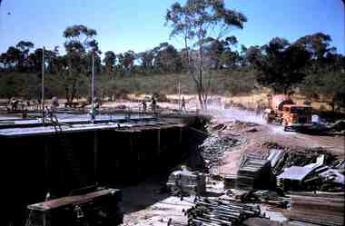
Slide - RALPH BIRRELL COLLECTION: EIG SCHOOL, c1966
EIG School - Ralph Birrell Collection. - Construction of Latrobe Uni. C1966. Bendigo Institute of Technology, Engineering School, Applied Science. Its full steam ahead, workmen everywhere, building supplies on the ground and a cement mixer just leaving the site. Markings: May 69M5.Kodakeducation, tertiary, latrobe university bendigo, eig school - ralph birrell collection. - construction of latrobe uni. c1966. bendigo institute of technology, engineering school, applied science. its full steam ahead workmen building supplies the ground cement mixer the site