Showing 6379 items
matching Mining
-
 Bendigo Historical Society Inc.
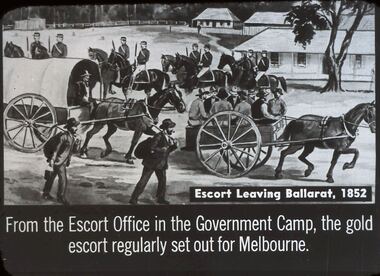
Slide - DIGGERS & MINING. THE GOLD LICENCE, c1852
Diggers & Mining. The gold licence. The Government Camp. Escort Leaving Ballarat, 1852. From the Escort Office in the Government Camp, the gold escort regularly set out for Melbourne. Markings: 21 994.LIF. 4. Used as a teaching aid.hanimounteducation, tertiary, goldfields -
 Bendigo Historical Society Inc.
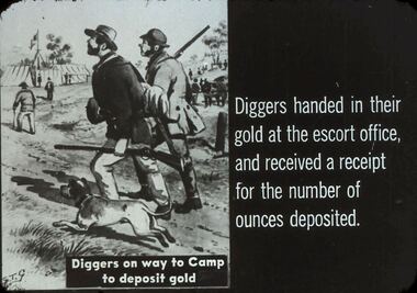
Slide - DIGGERS & MINING. THE GOLD LICENCE, c1850s
Diggers & Mining. The gold licence. The Government Camp. Diggers handed in their gold at the escort office, and received a receipt for the number of ounces deposited. Diggers on way to Camp to deposit gold. Markings: 20 994.LIF. 4. Used as a teaching aid.hanimounteducation, tertiary, goldfields -
 Bendigo Historical Society Inc.
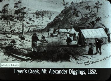
Slide - DIGGERS & MINING: THE DIGGINGS - THE DIGGERS
Diggers & Mining: The Digging - The Diggers. Slide depicts Fryer's Creek, Mt. Alexander Diggings, 1852. Shows tents, miners, small girl, not many trees at the foot of a hill. Markings: 16 994.LIF:6. Used as a teaching aid.hanimounteducation, tertiary, goldfields -
 Bendigo Historical Society Inc.
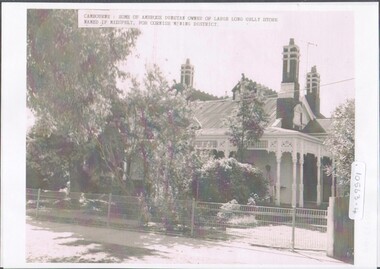
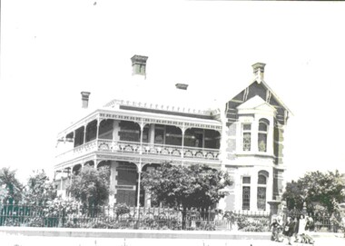
Photograph - Home of Ambrose Dunstan
This home "Crambourne" was designed by architect, Mr William Beebe and built around 1875 for Mr and Mrs Ambrose Dunstan, in Creeth Street, Long Gully.Cambourne, home of Ambrose Dunstan, who was owner of the Long Gully store. The house is named after the Cornish Mining District. Poor photocopy of Mr. Ambrose Dunstan, taken when he was mayor (not dated). Photocopies of originals, undated photographs.home and portrait of ambrose dunstan, ambrose dunstan mayor, cambourne, long gully -
 Wodonga & District Historical Society Inc
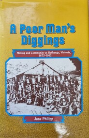
Book - A Poor Man's Diggings, June Philipp, 1987
The town of Bethanga is located in the mountainous north-east of Victoria, near the Murray River. In the 1870s miners and itinerant workers came to the area to seek their fortunes.This history of Bethanga, covering the period from 1875 to 1912, tells the story of these people and the community they created.A publication relating the history of mining at Bethanga in Northeast Victoria, the miners and semi-itinerant workers, who came to the area in the 1870s in search of a fortune and the community they created. Thus publication of 222 pages includes text, images, maps and a detailed index.non-fictionThe town of Bethanga is located in the mountainous north-east of Victoria, near the Murray River. In the 1870s miners and itinerant workers came to the area to seek their fortunes.This history of Bethanga, covering the period from 1875 to 1912, tells the story of these people and the community they created. gold mining bethanga, miners victoria, history of bethanga -
 Stawell Historical Society Inc
Handmade frypan
Hand Made by Joe Mitchell Alluvial Miner at Deep Lead. Died around 1991 age about 70 Blacksmither. Wroye to Stawell Time News about Metal Detecting. and Gold Mining in the 1980's Black Metal with HandleMade by Joe Mitchell Deep Lead -
 City of Ballarat Libraries
Photograph - Card Box Photographs, Former residence of Walter Davis, Ballarat c1950
This building in Victoria Street has ornamental brickwork, iron frieze balustrade, leadlight and chimney bay windows. It has been used as the Teachers College residence and thought to have been built by mining speculator, Forbes.victoria street, ballarat, private dwelling, building, walter davis, teachers college, forbes -
 Bendigo Historical Society Inc.
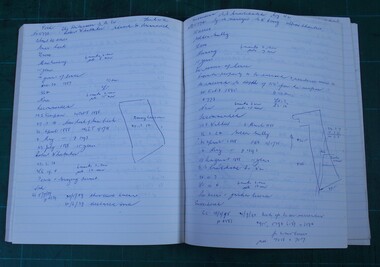
Administrative record - Land Leases 1886 - 1899
Dr Ralph Birrell (20/3/1927 - 7/6/2014) was a lecturer at the Bendigo School of mines and the author of numerous books about mining in Victoria, particularly Bendigo, and books on various elements of Bendigo history.Set of handwritten land leases books compiled by Ralph Birrell. Book 17: 5156/5573, year 1886. Book 18: 5574/5891. year 1887. Book 19: 5892/6211, year 1890. Book 20: 6212/6531, year 1893. Book 21: 6532/6849, year 1896. Book 22: 6849/71765, year 1897. Book 23: 7166/7390, year 1899.land leases, 1886-1899 -
 El Dorado Museum Association Inc.
Photograph (item) - Digital Image
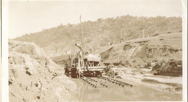
Cocks Pioneer Creek Diversion. Cocks Pioneer Electric Gold & Tin Mine Company was formed in 1899. The company's first power station, located at the eastern end of the valley began operating with its 340 Kilowatt steam-powered generator. By 1909, from 2,500,000 cubic yards worked, reported recovery was 17,284 ounces of gold and 224 tons of tin ore. By 1909, Cocks Pioneer’s power plant had become inadequate and uneconomical. The barge was floated downstream about a mile, but lost time caused the operations to cease. Following testing, a new mine was established by diverting Reid's Creek at a cost of £25,000. Settling dams were built, one of which held 1,935,900 cubic feet. Sold earth banks, built against a wall of stringy bark saplings constructed and laced with vertical props, were built. In 1914, the company was reformed as Cock’s Pioneer Gold and Tin Mines NL, another power station was constructed at the western end of the township, near the junction of Clear and Reid's Creeks. From 6,800,000 cubic yards of material processed, the returns were 64,397 ounces of gold and 855 ton of tin. Cocks Pioneer mine then moved the barge downs stream and continued sluicing. In 1929 Cocks Pioneer Electric Gold and Tin Mining Company ceased operations due to a drop in values. Cock’s Pioneer Gold and Tin Mines NL carried on large-scale hydraulic sluicing operations until 1941. mining, gold, tin, cocks pioneer, creek, gold mining, tin mining, el dorado, eldorado -
 El Dorado Museum Association Inc.
Photograph (item) - Digital Image
Cocks Pioneer old mine timbers. Cocks Pioneer Electric Gold & Tin Mine Company was formed in 1899. The company's first power station, located at the eastern end of the valley began operating with its 340 Kilowatt steam-powered generator. By 1909, from 2,500,000 cubic yards worked, reported recovery was 17,284 ounces of gold and 224 tons of tin ore. By 1909, Cocks Pioneer’s power plant had become inadequate and uneconomical. The barge was floated downstream about a mile, but lost time caused the operations to cease. Following testing, a new mine was established by diverting Reid's Creek at a cost of £25 000. Settling dams were built, one of which held 1,935,900 cubic feet. Sold earth banks, built against a wall of stringy bark saplings constructed and laced with vertical props, were built. In 1914, the company was reformed as Cock’s Pioneer Gold and Tin Mines NL, another power station was constructed at the western end of the township, near the junction of Clear and Reid's Creeks. From 6,800,000 cubic yards of material processed, the returns were 64,397 ounces of gold and 855 ton of tin. Cocks Pioneer mine then moved the barge downs stream and continued sluicing. In 1929 Cocks Pioneer Electric Gold and Tin Mining Company ceased operations due to a drop in values. Cock’s Pioneer Gold and Tin Mines NL carried on large-scale hydraulic sluicing operations until 1941. mining, gold, tin, open cut, gold mining, tin mining, cocks pioneer, el dorado, eldorado -
 The Beechworth Burke Museum
Photograph, c.1870
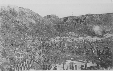
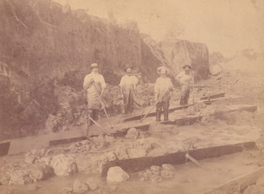
This photograph was taken in approximately 1870 and depicts four male miners standing in mining sluice at the Three Mile Goldfields. These men are wearing typical attire for 1870s gold miners. They wear white shirts, tan coloured pants with water proof shoes and most of the men are wearing an apron to prevent their clothing from becoming too dirty from the mud. Each man is wearing a wide brim hat and hold large wooden tools used for sorting through the sluice. Three of the four men have full beards. The photograph was donated to the Burke Museum by R. Ziegenbein before 2001 but the photographer and the individuals captured in the photo are unknown. The image depicts the landscape of the Three Mile Goldfields during a period when open cut sluicing was undertaken to reach gold. Open cut sluicing is a method used to extract gold and other precious metals from beneath the surface of the earth. This technique involved the use of high-powered hoses which broke down the soil enabling miners to come along and search this soil for gold. After the gold rush of the early 1850s, diggers had to enlist the assistance of heavy machinery and techniques like hydraulic sluicing in order to reach gold because the surface alluvial gold had already been discovered and removed. This heavy machinery was not used until after 1853. The Three Mile Goldfields was a site of rich alluvial gold deposits located about 5 km south of Beechworth in Victoria. Today, the location of this gold deposit is called Baarmutha. It was a popular area for gold mining in the 1850s but became largely abandoned by the following decade. In 1865, a man named John Pund recognized that the area could be potentially rich if a better water supply could be obtained. He secured a 15 year license with three other miners. Within the next five years, these men had constructed 19 km of water race going from Upper Nine Mile Creek to Three Mile Creek. By 1881, these four men had delivered 950,000 gallons to the Three Mile Sluicing area which is depicted in this photograph. Pund was later go into partnership with John Alston Wallace who would become owner of the Star Hotel in Beechworth. The Three Mile sluicing location continued to be operational until 1950. Sluice box workers were a vital part of gold mining regardless of how inefficient they were in the recovery of gold. After using hydraulic sluicing to cut away the earth, miners would use the big wooden boxes depicted in the image to catch the earth which would then be sifted for gold. However, accidents would occur often which would result in the gold washing away and unable to be recovered. It was not a very efficient system because the gold, which was alluvial and thus very fine, would often pass through the sluice box undetected.The search for gold is ingrained into the history of Victoria and therefore, images like this one which portray an open cut sluicing site can reveal important information for society and technology for the date when the photograph was taken. This image is of important historical significance for its ability to convey information about sluicing and the methods used to find gold in the late 1800s and early 1900s. It also shows a location where sluicing was undertook which provides insight into the impact of sluicing on the environment at a time when it was done. Images, like this one, of Australian gold rush history can reveal important information about the social and environmental impact of this period. This image depicts diggers standing in a mining location and therefore, this image has the capacity to reveal or support significant information for researchers studying the fashion and social status of diggers in Australia in approximately 1870. It can also provide information on the landscape of Australia in this period and the impact of mining for gold on both society and the Australian landscape. The Burke Museum is home to a substantial collection of Australian mining photographs which can be used to gain a deeper understanding into life on the gold fields, technology used in mining, the miners themselves and the impact of the gold digging on the environment.Sepia toned rectangular photograph printed on matte photographic paper and mounted on board.[illegible] about 1870 / 97 2514.1 / 2594 30three mile goldfields, goldfields, 1870, 1870 gold, australia, australian landscape, miners, gold miners, diggers, gold diggers, beechworth, victoria, sluice box workers, sluicing, sluice, mining -
 The Beechworth Burke Museum
Photograph, Unknown
The A1 Gold Mine is located north of Woods Point, near Jamieson, in the Upper Goulburn region of Victoria. Gold was discovered at the A1 site in 1861 and mining operations began in 1864. The A1 Mine Settlement refers to a small township known variously as Castle Reef, Castle Point, and Raspberry Creek, which developed in the 1860s around mining industry centred on a crushing machine that worked the three gold reefs in the area. Historically, the name "A1"referred to the high quality of gold found in the quartz reefs at depths of at least two thousand feet. Along with the Morning Star mine at Woods Point, the A1 gold mine produced almost sixty percent of Victoria's gold output in the 1950s to 1970s and continued operating until 1992 when it went into administration. Operations at the site were revived in 2016 and the A1 Mine is now considered one of Victoria's premier gold mines. The A1 mine is part of the extensive and prospective Lachlan Fold Belt, a north-west trending belt of tightly folded Early Devonian sedimentary rocks extending from New South Wales to Victoria. Mineralisation is hosted within or immediately adjacent to diorite dykes. Contemporary development of the 'Queens Lode' at the A1 mine signals a move from high-grade, narrow vein airleg mining into larger scale, mechanical mining designed to increase ore production volume. This original, undated photograph of the A1 Mine appears to depict an area or phase of disuse or abandonment. The aged and humble appearance of the cottage suggests association with the historical A1 Mine Settlement, therefore the image may have been taken prior to the 1950s-1970s revival period in which the A1 mine is known to have produced high gold yields. The photograph contributes to our understanding of the A1 Gold Mine's impact on the landscape and the social, environmental impacts of mining on communities and may be compared with others in the Burke Museum's extensive collection of mining photographs to deepen our understanding of mining in the Jamieson area.Black and white rectangular photograph printed on photographic paperReverse: 5577 / A1 Mine / Near Jamieson / Vic. /burke museum, beechworth museum, beechworth, gold fields, gold rush, victorian gold rush, mining tunnels, gold ming history, colonial australia, australian gold rushes, mining technology, beechworth historic district, indigo gold trail, indigo shire, upper goulburn shire, jamieson, woods point-walhalla goldfield, a1 gold mine, victorian high country, modern mining methods, orogenic gold province, gold mineralisation, devonian, dykes -
 Bendigo Historical Society Inc.
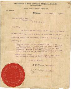
Document - JOSEPH DAVIES COLLECTION: LETTER FORM CHAMBER OF MINES VICTORIA, 29/07/1909
Letter from the Chamber Mines Victoria to Joseph Davies, Diamond Hill. Letter outlines a resolution congratulating Joseph Davies on his act of bravery in rescuing John Allan at the Goldfields Consolidated Mine. Letter typed on buff paper, red seal on bottom LH side.Chamber of Mines, Victoriaperson, mining, joseph davies, joseph davies, mining, chamber of mines, victoria -
 Bendigo Historical Society Inc.
Document - JOSEPH DAVIES COLLECTION: SCHOOL PAPER ARTICLE, 01/11/1928
Article in the School Paper Nov. 1 1928, detailing the efforts of Joseph Davies in rescuing John Allan in the Goldfields Consolidated Mine at Diamond Hill.person, mining, joseph davies, mining, the school paper, mr. joseph davies, john allan -
Bendigo Historical Society Inc.
Document - Digital, KEN BICE COLLECTION: SPECIMEN HILL UNITED MINE
Copy of photo: (also copy) Specimen Hill United Mine, image shows poppet head in centre of image, written on side 'Specimen Hill UCMS' Piles of mullock on RH and LH side in foreground. Two ore bins in front of poppet head.bendigo, mining, specimen hill united mine, bendigo, mining, specimen hill united mine, poppet head. -
Bendigo Historical Society Inc.
Document - Digital, KEN BICE COLLECTION: NEW ARGUS MINE
Copy of photo (also copy of photo): New Argus Mine, image shows poppet head right of centre, men lined up underneath. Sheds on LH side, written on boiler feeder tank 'New Argus …. Co' Railway line in foreground. This is a digital only photograph.bendigo, mining, new argus mine, bendigo, eaglehawk, new argus mine, mining -
Bendigo Historical Society Inc.
Photograph - KEN BICE COLLECTION: LANSELL'S 180 MINE, 3100 FT
Copy of photograph: Lansell's 180 Mine, 3100 ft. written on base of photo. In biro: taken early 1890's, very rich mine on Victoria Hill. Image shows poppet head on LH side, various timber buildings in centre, brick chimney in front of large shed. Needle chimney on Rh side. This is a digital only photograph.bendigo, mining, lansell's 180 mine, victoria hill, lansell's 180 mine, mining, needle chimney -
Bendigo Historical Society Inc.
Photograph - KEN BICE COLLECTION: VICTORIA QUARTZ ON VICTORIA HILL IRONBARK
Copy of photo (not original, also copied) showing poppet head on LH side, stone building in centre, chimney on RH side, timber shed behind. Logs strewn in foreground. Written on top Victoria Quartz on Victoria Hill, Ironbark, in 1910, the deepest gold mine in the world, early ground very rich. This is a digital only photograph.bendigo, mining, victoria quartz, bendigo, victoria quartz, victoria hill, mining -
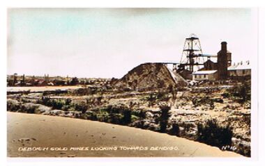 Bendigo Historical Society Inc.
Photograph - DEBORAH GOLD MINES ( NORTH DEBORAH ? )
Photo: Deborah Gold Mine ( un-named , possibly North Deborah ). Image shows poppet head, chimney, tailings dump. On Lh side of image, dam in centre foreground, On bottom of photo' Deborah Gold Mines looking towards Bendigo, No. 16 'bendigo, mining, deborah mine, bendigo, gold mines, deborah gold mine, mining -
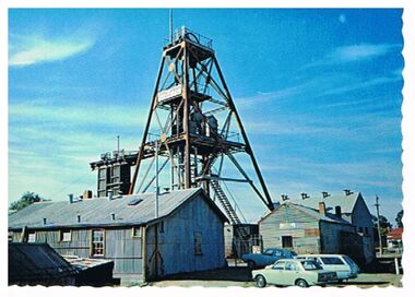 Bendigo Historical Society Inc.
Postcard - CENTRAL DEBORAH HISTORIC GOLD MINE, BENDIGO
Postcard - color. Image shows poppet head surrounded by galvanised iron sheds. Three cars parked on RH side. On back of card: ' Bendigo, Victoria, The Central Deborah Historic Gold Mine A Nu Color Vue of Australia.Nu Color Vuebendigo, mining, central deborah mine, bendigo, central deborah gold mine, history, mining -
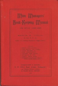 Bendigo Historical Society Inc.
Book - MINE MANAGERS BOOK-KEEPING MANUAL AND OFFICE COMPANION, 1910
MINE MANAGERS BOOK-KEEPING MANUAL AND OFFICE COMPANION. Author Edwin R. Field , printed by E.W. Cole Book Arcade Melbourne Hard cover book with 118 pages. Inscribed 'A.E. Richardson , 219 Harrison Street, Bendigo. ' on front cover page.Edwin R. Fieldgold, mining, mine managers, mining, mine managers, bendigo, accounting -
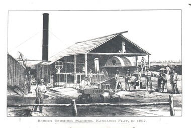 Bendigo Historical Society Inc.
Photograph - WES HARRY COLLECTION: CRUSHING MACHINE, 1857
Photograph of drawing of Bruce's Crushing Machine , Kangaroo Flat in 1857. On the reverse is written the number 3219.topic, mining, crushing machine, bruce's crushing machine, kangaroo flat, mining, early bendigo -
 Bendigo Historical Society Inc.
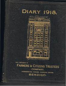
Document - MCCOLL, RANKIN AND STANISTREET COLLECTION: DIARY 1918, 1918
Document: McColl, Rankin & Stanistreet, diary 1918. Brown covered book, on front in gold embossed writing : 'Diary 1918, with compliments of Farmers & Citizens Trustees Company, Commercial House, Charing Cross, Bendigo.' Image of Commercial House, Charing Cross, Bendigo. Manager of Farmers and Citizens Trustees Company Bendigo Limited was R.A. Rankin ( McColl, Rankin & Stanistreet ) Diary contains loose documents including Bendigo Stock Exchange Price List 1918 ( 2 ) , A. Allsop & M.P. Kelly, stock and sharebrokers, Exchange, Bendigo , telegram to Mr. Michael P. Kelly, Wills St., Bendigo re share purchase, first and final notice New Red, White & Blue Consolidated Coy.organization, mining, diary 1918, mccoll, rankin & stanistreet, goldmining, mining -
 Bendigo Historical Society Inc.
Document - MCCOLL, RANKIN AND STANISTREET COLLECTION: MINES ACT VICTORIA 1928, 1928
Document: McColl, Rankin and Stanistreet Collection. Book covered in brown card tied with string on spine. On front in pen 'Mines Act Victoria 1928' 225 pages.Victorian Governmentorganization, mining, mines act 1928, mccoll, rankin and stanistreet, mining, goldmines -
 Orbost & District Historical Society
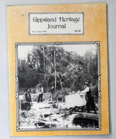
book, E-Gee Printers Pty Ltd, Gippsland Heritage Journal, June 1990
Gippsland Heritage Journal is a journal, produced about every nine - twelve months, for those interested in regional, local and family history in Gippsland, Victoria, Australia. It is compiled by Meredith Fletcher, Debbie Squires and Linda Barraclough and includes a diverse range of articles, both academic and non-academic. Since No.24 it has been a partially refereed journal. This copy was used in the library of Orbost Secondary College. This item is a useful reference tool on the history of Gippsland. A 64 pp magazine, titled Gippsland Heritage Journal No 8 (June 1990). The cost is $6.00. The front cover is pale orange with a b/w photograph of mining on Taraga River, Neerim South. The magazine contains photographs, articles on the history of Gippsland. -
 Federation University Historical Collection
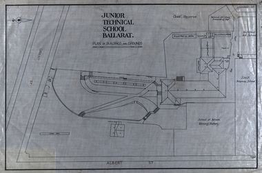
Plan, Plan of the Ballarat Junior Technical School Buildings and Grounds, 1923
The Ballarat Junior Technical School was a division of the Ballarat School of Mines. Plan of the Ballarat Junior Technical School, a division of the Ballarat School of Mines, The plan shows the Gaol Research, School of Mines Mining Battery, Common room, rifle range and cricket pitch. The school and grounds fronted Albert Street and Grant Street. gaol reserve, ballarat school of mines mining battery, model mine., mining battery, common room, rifle range, cricket pitch, albert street, grant street, ballarat school of mines, buildings, bicycle shed, ballarat technical art school, dressmaking, quoit court, architectural plans -
 Bendigo Historical Society Inc.
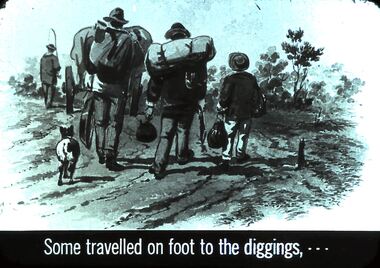
Slide - DIGGERS & MINING. THE GOLD ERA, c1850s
Diggers & mining. The gold era. Some travelled on foot to the digging, - - - Slide shows diggers with their belongings on their backs and bags in hand, and a dog following. One miner has a boy with him. Markings 13 994.031 GOL:5. Used as a teaching aid.hanimounteducation, tertiary, goldfields -
 Bendigo Historical Society Inc.
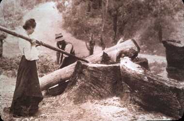
Slide - DIGGERS & MINING. LIFE OF THE SELECTORS, c1860
Diggers & mining. Life Of The Selectors. Women were always willing helpers with men's work. Markings; Life Of The Selectors Set 432 No. 13 ''The Pioneers'' by George Bell in '' The Story of the Camera in Australia.'' Cato, J., p33 (1955). Used as a teaching aid.Visual Education Centreeducation, tertiary, goldfields -
 Bendigo Historical Society Inc.
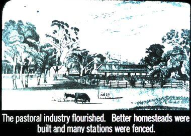
Slide - DIGGERS & MINING. THE GOLD ERA, c1850s
Diggers & mining. The gold era. The pastoral industry flourished. Better homesteads were built and many stations were fenced. Slide shows some of the fencing and shelters added to homesteads. Markings 56 994.031 GOL:5. Used as a teaching aid.hanimounteducation, tertiary, goldfields -
 Bendigo Historical Society Inc.
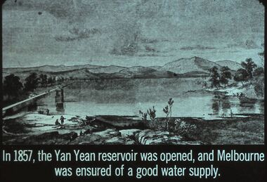
Slide - DIGGERS & MINING. THE GOLD ERA, c1857
Diggers & mining. The gold era. In 1857, the Yan Yean reservoir was opened, and Melbourne was ensured of a good water supply. Slide shows a good picture of the lake with a couple of people in the foreground. Markings 55 994.031 GOL:5. Used as a teaching aid.hanimounteducation, tertiary, goldfields