Showing 3530 items
matching gold mining.
-
 Federation University Historical Collection
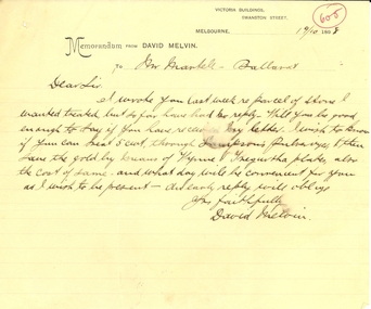
Correspondence, David Melvin, David Melvin to Frederick Martell of the Ballarat School of Mines, 1898, 19/10/1898
... . Ballarat School of Mines David Melvin mining gold Sampson's ...The Ballarat School of Mines conducted assays at the Model Mine. handwritten memorandum on David Melvin letterhead relating to treatment of a a parcel for extraction of gold. ballarat school of mines, david melvin, mining, gold, sampson's pulverizer, wynne and tregurtha plates -
 Federation University Historical Collection
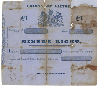
Document, Miner's Right issued at Ballarat, 1856
... Colonists’ Hall. miner's right mining gold ballarat old colonist's ...This miner's right is a copy from an original held by the Old Colonists' Association of Ballarat. The original was glued onto a page in a large album of photographic images of early Ballarat. Recognising their significance the Council of the Old Colonists’ Association had them removed and restored. The originals are now framed and on display in the Old Colonists’ Hall. Blue Miner's Right issued at Ballarat in the Colony of Victoria.miner's right, mining, gold, ballarat, old colonist's association of ballarat -
 Federation University Historical Collection
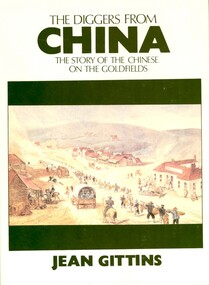
Book, Jean Gittins, The Diggers from China: the story of the Chinese on the goldfields, 1981
... . chinese goldfield lambing flat immigration mining gold geoffrey ...Soft covered book called 'the Diggers from Chine: the Story of the Chinese on the goldfields'. The book is 148 pages and contents include the Celestial empire, the journey, Mountains of gold, Off to the Diggings, Toil and Strife, the way they lived. Appendix A is the report submitted to the Victorian Parliament by the Select committee on the Subject of Chinese Immigration in 1857.chinese, goldfield, lambing flat, immigration, mining, gold, geoffrey blainey -
 Federation University Historical Collection
Booklet, Robert Brain, Government Printer, Mineral Statistics of Victoria for the Year 1880-1881, 1881
... flagging slates quartz mining gold districts ballarat beecworth ...White Foolscap printed Government document relating Victoria's mineral statistics.statistics, mineral statistics, h.r. williams, gold yeild, gold, silver, tin, copper, antinomy, lead, iron, coal, lignite, kaolin, flagging, slates, quartz mining, gold districts, ballarat, beecworth, bendigo, sandhurst, maryborough, castlemaine, ararat, gippsland, water rights, gunpoweder, mining companies -
 The Beechworth Burke Museum
Photograph
... of Beechworth that was possibly used as a sluicing mining site for gold... that was possibly used as a sluicing mining site for gold during ...This image shows an unknown location in the area of Beechworth that was possibly used as a sluicing mining site for gold during the Victorian Gold Rush. This era saw an influx of Chinese immigrants and Australian prospectors hoping to strike it rich on the fields. Many companies such as the Rocky Mountain Extended Gold Sluicing Company Ltd and the Cocks Pioneer Gold &Tin Sluicing Company also set up mines in the area. This site may be the location of one of these company's mines. The wooden logs are reminiscent of known sluicing operations in the era from that time. Sluicing involved the use of high-pressured hoses to clear away soil from earth that had been dug up by miners and was a popular method of excavation in the area, although it had severe impacts on the environment.The search for gold is ingrained into the history of Victoria and therefore, images like this one which portray an open cut sluicing site can reveal important information for society and technology for the date when the photograph was taken. This image is of important historical significance for its ability to convey information about sluicing and the methods used to find gold. It also shows a location where sluicing was undertook which provides insight into the impact of sluicing on the environment at a time when it was done.A colour rectangular photograph printed on glossy photographic paperReverse: 6855 /beechworth, gold rush, sluicing, mining -
 The Beechworth Burke Museum
Photograph
... sluicing gold sluicing hydraulic sluicing mining gold and quartz ...This photograph dating between the 1850s and early 1900s depicts an open cut sluicing site located in Allan's Flat looking upon the open cut from Staghorn Flat Number 1. Sluicing was undertaken in the area from 1850 to 1904. The image depicts a location mined by Yackandandah Sluicing Co. It portrays and open space with pipes laying on the ground and connected to pipes leaving the barge. These pipes were used to wash and seperate the qaurtz. There are two small buildings on high ground over looking the barge. Yackandandah Sluicing Co. was created by J.A. Wallace in the 1880s. The Yackandandah Sluicing Co. operated from the mid-1880s to the early 1900s, when resources eventually ran out. Open cut sluicing involved the use of high-powered hoses which used the centrifugal sand pump system (known as hydraulic sluicing) which broke down the soil which was then processed for quartz, gold and other materials. After the resources where drained, Wallace reaped the benefits of his mining business. Allan's Flat is located on the Yackandandah Creek, and is 10km north-east of Yackandandah and 20km south of Wodonga in Victoria's regional north-east. Allan's Flat was initially used to mine gold through alluvial methods, however that came to an end with little results. The mining business was then revived by J.A. Wallace with the introduction of hydraulic sluicing.The search for gold is ingrained into the history of Victoria and therefore, images like this one which portray an open cut sluicing site can reveal important information for society and technology for the date when the photograph was taken. This image is of important historical significance for its ability to convey information about sluicing and the methods used to find gold and other minerals in the lat 19th Century. It also shows a location where sluicing was undertook which provides insight into the impact of sluicing on the environment at a time when it was done. This image is important for current research into the history of Allan's Flat, a small regional location near Yackandandah in Victoria's North East. Therefore, this image has the capacity to be beneficial for research into society and the motivations of those living and working in this region during this period and therefore, has social significance. The Beechworth Burke Museum has additional images relating to gold sluicing and Allan's Flat which can be analysed and studied alongside images like this one.Sepia coloured retangular photograph printed on gloss photographic paper mounted on board.Revers: Sluicing at Allan's Fortallan's flat, north east gold, sluicing, gold sluicing, hydraulic sluicing, mining, gold and quartz mine, beechworth, burke museum, yackandandah -
Kew Historical Society Inc
Book, Geoff Hocking, Castlemaine : from camp to city 1835-1900, a pictorial history of Forest Creek & the Mount Alexander goldfields, 1994
... Gold mines and mining -- Victoria -- Castlemaine -- History... donation, presentation, collection and purchase. Gold mines ...230 p. : ill. (some col.), facsims, maps, ports. ; 22 x 25 cm.non-fictiongold mines and mining -- victoria -- castlemaine -- history, castlemaine (vic.) -- history -
Koorie Heritage Trust
Book, Banfield, Lorna L, Like the ark : the story of Ararat, 1955
... | Gold mines and mining -- Victoria -- History | Colonisation... -- Ararat -- History | Gold mines and mining -- Victoria -- History ...A history of the settlement of Ararat by one of the descendants. Most references to Aboriginal people in Chapter IV (scattered references elsewhere). Early relations between Kalkadoondeet (Kalkatungu) and Jajowurrung (Djadjawurrung) people and settlers. Violence and retribution reulting from tensions over the grazing and destruction of settlers, sheep and cattle which had overrun their waterholes and hunting groungs. Numbers and names of some Aboriginal people killed in the Ararat region. Establishment of rival 'sheep stations' by the Djadjawurrung people led by King Billy Billy.202 p. :ill ; 22 cmA history of the settlement of Ararat by one of the descendants. Most references to Aboriginal people in Chapter IV (scattered references elsewhere). Early relations between Kalkadoondeet (Kalkatungu) and Jajowurrung (Djadjawurrung) people and settlers. Violence and retribution reulting from tensions over the grazing and destruction of settlers, sheep and cattle which had overrun their waterholes and hunting groungs. Numbers and names of some Aboriginal people killed in the Ararat region. Establishment of rival 'sheep stations' by the Djadjawurrung people led by King Billy Billy.ararat (w vic sj54-08) | western district (w vic sj54-07) | king billy billy | pioneers -- victoria -- ararat -- history | gold mines and mining -- victoria -- history | colonisation | food | settlement and contacts - settlers | race relations - violent - massacres, murders, poisonings etc. - to 1900 | economic sectors - agriculture and horticulture - pastoral industry - sheep and wool | djadja wurrung / dyadyawurrung / dja dja wrung people (s31.1) (vic sj54-04) -
Koorie Heritage Trust
Book, Bowden, Keith MacRae, Goldrush doctors at Ballaarat, 1977
... Victoria -- History. | Gold mines and mining -- Victoria... Victoria -- History. | Gold mines and mining -- Victoria ...An historical account of events and doctors during the goldrush era at Ballarat.xiii, 125 p. : ill. (part col.), map ; 1977An historical account of events and doctors during the goldrush era at Ballarat. doctors. victoria. ballarat. gold fields, 1850-1860. | physicians -- ballarat, victoria -- history. | gold mines and mining -- victoria -- ballarat. -
Stawell Historical Society Inc
Book, Bob Bingley Watchorn, Getting Shafted and Loving It, 2010
... on Stawell Mining Gold Bob Bingley Watchorn ASASHIC Intellectual ...Chapter 6 on StawellEscapades From high Above and Deep BelowBob Watchorn Enjoy 17/01/20mining, gold -
Stawell Historical Society Inc
Joiner, Joiner from Diamond Drill, C. 1955
... still in Place Mining Gold Ron Coward ...Dimond drills are put down to identify locations of gold bearing ore deposits, before mining drives are put in to extract the Ore. Sectionso fth eDimond Drill core are analyised for gold content. Drill joiner found near shaft no 26 in Ironbarks, near the intersection of Golf Course & southwest road. Conctrete shaft Cover still in PlaceMetal pipe threaded at both ends, used to join diamond Drill pipeing c 1955mining, gold -
Stawell Historical Society Inc
Map, Underground Survey of the Principal Mines of Stawell 1879, 1879
... cross United, Great Northern Shaft Mining Gold ...Pleasant Creek & Newington, Prince Patrick, Prince Alfred, Pioneer and Galatea, Pleasant Creek Cross Reef No. 1&2, Magdala, Old Shaft, Extended Cross Reef, Crown Cross, Great Northern, Sloanes & Scotchmans, South Cross, 10 & 11 United Scotchmans South Cross, Scotchmans Shafts, North Scothmans, West Scotchmans, Emerald Isle & Rose of Denmark, Albion, South Scotchmans, Newington & Pleasant Creek, Pleasant Creek Cross Reef, Moonlight, Extended Cross Reef, Crown cross United, Great Northern ShaftVery large Map on cloth backing, showing cross sections of mines.Surveyed by H.C. Bates. Drawn by Arthur Edwards. October 30th 1879. Scales 120 feet to an inchmining, gold -
Stawell Historical Society Inc
Archive, Stawell Gold Mine, Stawell Gold Mine Emergency Plan, 1/08/2015
... Plans and Conatacts. Mining Gold Stawell Gold Mine ...Plans produced by Mine for Emergency use showing ventilation & Emergency Exits Plans and Conatacts.Ring Bound A3 book with laminated Covers & Black and Yellow Banding for attentionDate of Issue 31/ 08/2015 Uncontrolled Copymining, gold -
 El Dorado Museum Association Inc.
Photograph - Digital Image
... . Rankins Orchard and Sluicing Ponds, c1930s. mining gold tin ...Rankins Orchard and Sluicing Ponds, c1930s.mining, gold, tin, sluicing, orchard, farming -
 Stawell Historical Society Inc
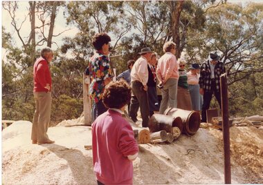
Photograph, Joe Mitchell's Mine
... , Dorothy King, Leslie Bennett, Lawrie Bennett. Mining Gold ...Stawell Historical Society Members visit Joe Mitchell's mine in the Ironbark, forest near Deep Lead. L to R Ian Jackson, Carmel Loats, Thelona Bullock, Allan Kingston, Betty Jackson, Betty Collins, Dorothy King, Leslie Bennett, Lawrie Bennett.Colour Photograph of a Group of people standing, looking down a mine shaft in bushland.mining, gold mininging, stawell historical society, deep lead -
Stawell Historical Society Inc
Map, Northern Grampians Shire, Town of Stawell Planning Scheme, 1981
... ) Scale 1 : 3168 ie 4 Chains = 1 inch Mining gold Northern ...Amendment No 21 (1981) Scale 1 : 3168 ie 4 Chains = 1 inchmining, gold -
Stawell Historical Society Inc
Map, Western Mining Corp / Stawell Joint Venture, Three dimensional View of Wonga Open Cut & Decline, April 1992
... with Cut Away Showing Underground Development Floorplan Mining Gold ...Cutaway perspective showing DeclinesView Looking North West with Cut Away Showing Underground Development Floorplanmining, gold -
Stawell Historical Society Inc
Map, Stawell Gold Mine, Three dimensional View of Magdala Decline, March 1994
... depth in metres below hill Parallel View Scale 1 : 2600 mining ...View of Mine looking from Stawell Hospital towards Big Hill Levels indicate depth in metres below hillParallel View Scale 1 : 2600mining, gold -
Stawell Historical Society Inc
Map, Stawell Gold Mine, Plan Showing Wonga Pit and Underground Development, August 2001
... Stawell Gold Mines Victoria Scale 1 : 2500 mining gold Stawell ...Stawell Gold Mines Victoria Scale 1 : 2500mining, gold -
Stawell Historical Society Inc
Map, Stawell Gold Mine, Tenement Boundaries Stawell Township 2001, August 2001
... mining gold Stawell Gold Mine ...Showing Underground Development Stawell Gold Mines Victoria Scale 1 : 20000mining, gold -
Stawell Historical Society Inc
Map, Stawell Gold Mine, Milling Area Site Arrangement 2002, 12/6/2002
... Levels Stawell Gold Mines Victoria Scale 1 : 20000 mining gold ...Plus Bench Mark Levels Stawell Gold Mines Victoria Scale 1 : 20000mining, gold -
Stawell Historical Society Inc
Map, Stawell Gold Mine, Perspective View Magdala Decline August 1989, August 1989
... SJV mining gold Stawell Gold Mine D Bosher ...Shows Mining Levels Drawn By D. Bosher Stawell Joint Venture Victoria SJVmining, gold -
Stawell Historical Society Inc
Map, Stawell Gold Mine, Plan of Surface Topographical Detail, 27 March 2007
... mining gold Stawell Gold Mine ...Stawell Victoria Showing Magdala Decline as at 27 March 2007 Stawell Gold Mines mining, gold -
Stawell Historical Society Inc
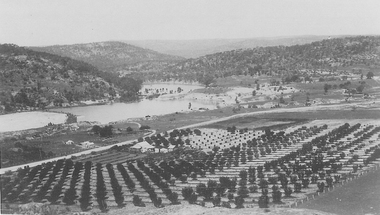
Photograph, Panorama of Wonga Open Cut 1984
... grampians Photograph Panorama of Wonga Open Cut 1984 Mining Gold ...mining, gold, panorama -
Stawell Historical Society Inc
Photograph, Panorama of Davis Open Cut August 1987
... grampians Photograph Panorama of Davis Open Cut August 1987 mining ...mining, gold, panorama -
Stawell Historical Society Inc
Photograph, Davis Open Cut West Wall North End
... of Stripping 1987 mining gold panorama ...Photo of Stripping 1987mining, gold, panorama -
Stawell Historical Society Inc
Photograph, Davis Open Cut 24/28 meter South Wall 1987
... mining gold panorama ...mining, gold, panorama -
Stawell Historical Society Inc
Photograph, Davis Open Cut 1987
... grampians Photograph Davis Open Cut 1987 mining gold panorama ...mining, gold, panorama -
Stawell Historical Society Inc
Photograph, Davis Open Cut East Wall North End 1988
... grampians Photograph Davis Open Cut East Wall North End 1988 mining ...mining, gold, panorama -
Stawell Historical Society Inc
Map, Township of Stawell Photo Map, 1947
... from Air Circa 1947. Shows mining sites and township mining ...Photograph of Stawell from Air Circa 1947. Shows mining sites and townshipmining, gold, map