Showing 123963 items
matching main-road
-
 Surrey Hills Historical Society Collection
Photograph, Denholm's Garage, 209 Union Road, Surrey Hills
Fred Lyons (cab driver) and Dave Denholm (garage proprietor) worked together in a business servicing cars and providing vehicles for weddings etc. The photo came as part of a donation of photos related to Fred Lyons, his family and business. The building and automotive business was taken over and became J & V Warren-Smith Auto Service. In 2018 it is managed by John and Val's son Phillip and is believed to be the only business in the Union Road shops with a continuous history of use.A back and white photograph of a garage called Union Motor Garage. It has a brick facade, with an arched window either side of the driveway. A petrol bowser stands in front of each window. There is a car in the driveway.On small card: Union Motor Garage / D. B. Denholm, Proptr. / 209 UNION ROAD, SURREY HILLS / Phone Box Hill 959 / AUSTIN OAKLAND / PONTIAC DOUGLAS.::denholm's garage, union motor garage, union road, surrey hills, (mr) dave b. denholm, (mr) fred lyons, petrol stations, petrol pumps, j & v warren-smith auto service -
 Whitehorse Historical Society Inc.
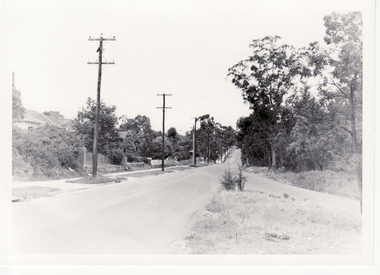
Photograph, Blackburn Road Looking South, 1960
Black and white photograph of Blackburn Road looking south from Canterbury Road in January 1960. Note lampposts and made footpath on the left side.blackburn road, canterbury road -
 National Wool Museum
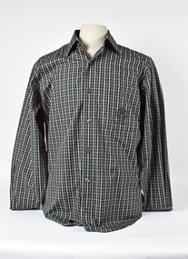
Uniform - Shirt, Country Road, c.2000
Australian shirt from the Sydney 2000 Olympic Games unisex casual uniform (option 2). Designed by Country Road.Blue and white tatterstall shirt with 2000 Australian Olympic emblem on right breast pocket. AUSTRALIA SYDNEY 2000fashion, woolmark company country road, sport, the woolmark company 2000 australian olympic display - exhibition (21/12/2001 - 24/05/2002), sydney 2000 olympic games -
 National Wool Museum
Uniform - Jacket, Country Road, Sydney 2000 Olympic Games Australian Unisex Casual Jacket, c.2000
Australian jacket from the Sydney 2000 Olympic Games unisex casual uniform (option 1). Designed by Country Road.Cream collared jacket with zip. Australian Sydney Olympics emblem embroidered on right breast. SYDNEY 2000fashion, woolmark company country road, sport, the woolmark company 2000 australian olympic display - exhibition (21/12/2001 - 24/05/2002), sydney 2000 olympic games -
 National Wool Museum
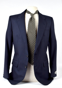
Clothing - Suit Jacket, Suit Pants and Tie, Flair, 1980s
Navy blue pinstripe suit jacket and pants. Charcoal tie with a tan geometric print. Printed [inside jacket tag]: Flair / COOL / WOOL / WARM IRON / DRY CLEAN ONLY / PURE NEW WOOL Printed [tie label]: Country Road Australia / Made in Italy Printed [pants label] No. 9722fashion, wool, men's suit, clothing, fabric, australian made, tie, pants, jackets, design, textile -
 Kiewa Valley Historical Society
Black and White photograph of Road Making Machinery, Kiewa Road Making, 25/08/1938
Construction of the main road from South Tawonga to the Bogong High Plains, to provide access to the construction sites for the new Kiewa Hydro Electric Scheme, was commenced early in 1938, the work being undertaken on behalf of the Commission by the Country Roads Board. For the construction work, the Commission purchased three Caterpillar - model R07 - diesel crawler tractors equipped with Kay Brunerei (Brunner) hydraulically operated trailbuilders (angle dozers). This acquisition resulted from a visit to the United States of America in May, 1937 by the Construction Engineer ( Mr. C.H. Kernot) and Assistant Civil Engineer (Mr. J.F. Douglas) where they saw this relatively new type of equipment in use. With the co-operation of the CRB, the Commission demonstrated the operation of these machines at Fishermen's Bend on 6th April, 1938. They were then sent to Kiewa where they commenced operation towards the end of the month. From South Tawonga, the route led immediately across the Western Branch of the Kiewa River necessitating the construction of a bridge 100 feet long. By the end of 1939, the excavation had been 'opened up' for a distance of 19 1/2 miles (approx. 31 km) and of this length, 10 miles (approx. 16 km) had been surfaced.The purchase and use of this type of mechanical equipment in road making was a huge investment, as prior to this most of the work would have been done manually with the use of picks and shovels. Not only were many months of hard manual labour saved, but a very significant amount of time in providing access to the proposed work sites for the new Kiewa Hydro Scheme. This photo is an excellent reminder of how primitive the early machinery was compared to the present but also represents the forward thinking of the State Electricity Commissions engineers in purchasing such innovative equipment . A black and white photograph showing the type of machinery used for road making in the 1930's. It shows a grader being towed by a caterpillar tractor.On the top left hand corner of the photograph , hand written in black ink is the words 'Kiewa Road Making 25/8/1938'. On the right hand side of the photo has been stamped in blue the Number 1. It has been developed on Velox paper (marked on back of photo) with a gloss finish.road making, state electricity commission, caterpillar tractor, kiewa -
 Phillip Island and District Historical Society Inc.
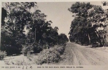
Photograph, Road to Back Beach, Cowes
Part of a collection of 'Rose & Valentine' series of Post Cards. Copied by John Jansson 1984Black & White Postcard. Road to the Back Beach, Phillip IslandThe Rose Series P662. Road to the Back Beach, Cowes, Phillip Island, Victorialocal history, photography, photographs, postcards, phillip island, black & white postcard copy., back beach -
 Whitehorse Historical Society Inc.
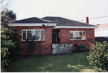
Photograph, 217 Whitehorse Road, Blackburn, 1/08/1998 12:00:00 AM
Coloured photo of 217 Whitehorse Road, Blackburn.whitehorse road, blackburn, no.217. -
 Ballarat Heritage Services
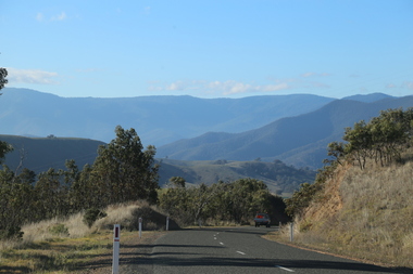
Digital Photograph, Road Near Omeo, Victoria, 2017
Colour photograph of the road near Omeo, Victoria.2017, great alpine road, omeo high plains, omeo, australian alps, high country -
 Tarnagulla History Archive
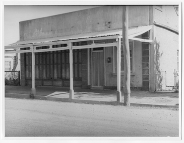
Photograph looking down Commercial Road, Tarnagulla, Looking down Commercial Road, Tarnagulla, c.1960s
Murray Comrie Collection. Shopfront located on west side of Commercial Rd between King and Poverty Streets. Original print.Monochrome photograph of a shopfront in Commercial Road, Tarnagulla. tarnagulla, buildings, businesses, commercial road -
 National Wool Museum
Uniform - T-shirt, Country Road, Sydney 2000 Olympic Games Casual Australian Uniform, c.2000
Australian t-shirt from the Sydney 2000 Olympic Games unisex casual uniform (option 1). Designed by Country Road.White T-Shirt with Australian emblem and Sydney 2000 Olympic logo on left sleeve. AUSTRALIA SYDNEY 2000fashion, woolmark company country road, sport, the woolmark company 2000 australian olympic display - exhibition (21/12/2001 - 24/05/2002), sydney 2000 olympic games -
 Melbourne Tram Museum
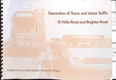
Document, Melbourne & Metropolitan Tramways Board (MMTB), "Separation of Trams and Motor Traffic - St Kilda Road and Brighton Road", May 1979
Document prepared to provide the concepts for separation of traffic along St Kilda Road and Brighton Road using safety bars, and reserved sections of roadway between Princes Bridge and Glen Huntly Road. Dated May 1979. Has an introduction, and notes the widening of St Kilda Road south of Cochrane St and its impact. Has colour photo of Z89 in Nicholson St where the Safety bars had been installed to separate traffic, installation of Safety Zones, photos of Gothenburg, Amsterdam, and Hanover showing traffic separation, graphs showing tram passenger movement in the am peak and road usage. Looks extensively at the Domain Interchange at Park and Domain Road and the suggested layout - which was implemented in Nov. 1986. Includes a photo of a very long line of trams northbound at this intersection which has undergone many changes location, to become during 2025 the entry to Anzac station. Six drawings show the proposed separation of traffic between Alexandra Ave and Glen Huntly RoadDemonstrates a planning document to separate road traffic from trams along St Kilda Road.Comb bound document titled "Separation of Trams and Motor Traffic - St Kilda Road and Brighton Road" - 12 sheets + card covers, some full colour pages with some sheets folded.tramways, st kilda road, traffic control, domain interchange, domain road, reserved track -
 Victorian Interpretive Projects Inc.
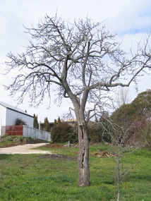
Photograph - Colour, Clare Gervasoni, Fabrizio Crippa's Pear Tree, Hepburn Springs, 27/08/2006
Fabrizio Crippa of Monza, Italy built a double storey villa in 1864 on the Main Road in Hepburn Springs. The surrounding land was planted with vines and fruit trees. The pear tree is most probably one of Fabrizio Crippa's original plantings.Am old pear tree stands in a garden with a building in the back ground. hepburn, hepburn springs, pear, villa parma, parma house, crippa, fabrizio crippa -
 Surrey Hills Historical Society Collection
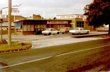
Photograph, Faraday & Kent, 172 Union Road Surrey Hills, 1979
This site was previously occupied by a Golden Fleece petrol station and later by Cobb & CO car rental. In Paul Towers bought the property from Faraday & Kent, for whom Norm Henderson was the proprietor, in 1996. In 2003 it was bought by Evan Lewis. (NOTE re source: undated note re verbal history given by un-named person).A colour photograph of the corner of Guildford Road and Union Road. There are four cars parked in front of a building. There is a sign identifying Faraday & Kent - home painting and wallpaper.guildford road, surrey hills, faraday & kent, businesses, paint shop, union road, norman henderson, evan lewis, paul towers, norm henderson -
 Whitehorse Historical Society Inc.
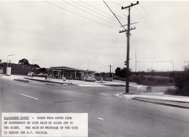
Photograph - Black and white photo, South side of Canterbury Road, Blackburn South, 9/11/1962 12:00:00 AM
Black and white photo taken from South side of Canterbury Road with Main Street going off to the right. Blackburn South.blackburn fibrous plaster works, industries -
 Tarnagulla History Archive
Photographs of postcard: Commercial Road Showing Union Bank, Commercial Road Showing Union Bank, circa 1890-1900
Donald Clark Collection. Two photographic copies of a postcard titled 'Commercial Road Showing Union Bank'. Depicts main street of Tarnagulla. Copy photograph. streets, buildings, bank -
 Glen Eira Historical Society
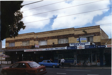
Photograph, Murrumbeena Road, 229-229A-231-231A-233, Murrumbeena, 2001
Originally labelled "Beauville Estate, Established 1936, Still Thriving 65 years on, 10th March 2001", the Beauville Estate Album contains colour photographs of houses in the Estate. They were taken around the time of the Beauville Estate’s 65th Heritage Celebration held on 10/03/2001 and donated to the Caulfield Historical Society shortly afterwards. Photographer unknown. 227 Murrumbeena Road (Bev Baxter Chemist) is not part of HO12.City of Glen Eira’s Heritage Management Plan Vol 2 p79 (this is p84 of the pdf version) – HO12 Beauville Estate and environs, Murrumbeena: The Beauville Historic Area is important at the State level as the first large housing estate undertaken by the AV Jennings Construction Co, later Jennings Group Limited, Victoria’s largest home builder. It is important also as a very early estate development incorporating a range of features other than houses and including made roads, shops and recreation facilities. In this respect it was the forerunner of the comprehensively planned housing estate of the post war era. The estate is distinguished by its aesthetic values, as is the earlier and comparable Hillcrest Estate, which are formed by a combination of restrained diversity in house styles, with the exception of no. 30 in the emerging International style, and by a landscaped garden environment. Colour photograph of a group of commercial properties with ground level shops and upper level two toned brown, unpainted brick residences. The photograph taken from across the road also includes parked cars, a person leaning on a car outside the fish and chip shop and a pedestrian crossing the road. Shops shown are from left to right: Cafe Fresca, 231 Hair Creations, Leovorno Pizza, Blue Sea Fish & Chips, Murrembeena (sic) Milk Bar and a portion of the one storey shop Bev Baxter Chemist at the right end. LEOVORNO PIZZA / BLUE SEA FISH & CHIP / Herald Sun / Sunday / MURREMBEENA MILK BAR / PK's / SANDWICH BAR / Bev Baxtermurrumbeena, architectural styles, 1930's, inter war style, a.v. jennings, av jennings, jennings, beauville estate, murrumbeena road, commercial establishments, shops, pharmacies, milk bars, fish shops, sir albert victor jennings, a v jennings construction co, beauville estate heritage area, glen eira city council, architectural features, jennings group limited, land subdivision, beauville historic area, brick shops, brick features, hairdressers, pizza shops, restaurants -
Glenelg Shire Council Cultural Collection
Photograph, Main Breakwater Construction, n.d
Port of Portland Archivesport of portland, breakwater construction -
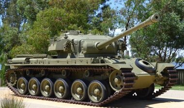 Yarrawonga RSL Sub Branch
Centurion tank, Centurion Mk5 main battle tank, Early 1950's
Vietnam War Troops of the 1st Australian Armoured Regiment during a briefing at Vung Tau In 1967, the Royal Australian Armoured Corps' (RAAC), 1st Armoured Personnel Carrier (APC) Squadron transferred to "A" Squadron, 3rd Cavalry Regiment Vietnam. Although they successfully conducted combat operations in their areas of operation(s) (AOs), reports from the field stated that their light-armour (M-113 ACAVs) were unable to force their way through dense jungle[15] limiting their offensive actions against enemy forces. The Australian government, under criticism from Parliament, decided to send a Squadron of Australian Centurion tanks to South Vietnam.[15] The 84 mm-gunned[16] Australian Centurions of 'C' Squadron, 1st Armoured Regiment landed in the Republic of Vietnam (South Vietnam) on 24 February 1968, and were headquartered at Nui Dat in III Corps (MR3).[17] 52 Ton main battle TankARN Number 169090 and tacsign 106tank armoured vietnam centurion mbt -
Surrey Hills Historical Society Collection
Ephemera, H Bowley, Printer, 192 Canterbury Road, Canterbury, Theatre program - The Arcadians, 17 May 1932, May 1932
William Lock lived at 9 Suffolk Road, Surrey Hills. Donation made at time Libby Cavenagh was Secretary of the Surrey Hills Historical Society.Cream-coloured bi-fold paper program with one corner roughly torn off. [This acted as the admission slip / ticket.] This does not diminish the information. Includes a cast list and synopsis of the three acts."1/1" in lead pencil across the front.camberwell town hall, operetta, the arcadians, wimperis and monckton, surrey hills operatic society, j c williamson, winslow's news agency, entertainment, musical events and activities, miss lilian horn, mr h brett, mr cocking, mr alan abery, mr o danvers, mr foffie, mr j rowse, mrs kennedy, miss u blaikie, miss f callaghan, miss broderick, miss j gordon, mr h denny, mr h collins, mr m latimer, mrs p d clucas, miss i roderick, miss m collins, mr darby, miss phyllis heitsch, miss pearson -
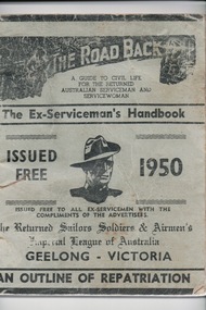 Lara RSL Sub Branch
Handbook, W.A.Cooney, The Road Back, 1947/1950
The handbook was distributed to all ex-servicemen on return from WW2 in the Geelong area and was a guide to civil life.This booklet for returned service personnel from World War 2 living in the Geelong Region is og local district significance as a part of the history of Geelong.The Road Back -two of The Ex-Serviceman's Handbooks,1947/ 1950 Geelong Issued Free.One is Light green in colour with black writingThe Road Back The Ex-Serviceman's Handbook Geelong.the road back, the ex-serviceman's handbook, world war 2, ww2, australian aif, australian serviceman, australian servicewoman, rss&aila, army, navy, air force, returned sailor's, soldier's and airmen's imperial league of australia, rsl -
 Camberwell Historical Society
Photograph, Camberwell, Victoria, looking south down Burke Road in Camberwell, c. 1950
Print of photograph looking south down Burke Road. Inscription 'Camberwell, Victoria, looking north down Burke Road in Camberwell c. 1950' which is actually incorrect because it is looking south. Camberwell, Victoria, looking north down Burke Road in Camberwell c. 1950camberwell -
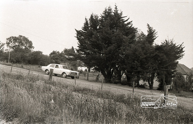
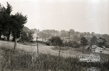
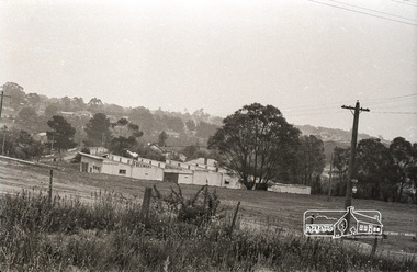
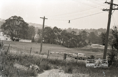
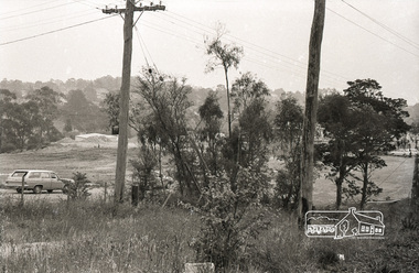
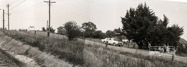
 Eltham District Historical Society Inc
Photograph, Sherbourne Road, Para Road and Simms Road at Briar Hill, 3 November 1967, 3 Nov 1967
Viewed from railway line opposite Graham Body Works. Simms Road is running to the right in front of the old house. The house belongs to Mrs Cameron whose daughter married a DAVEY after which Davey Street is named. Excavation work is being undertaken for the realignment of the Para Road and Sherbourne Road intersection where the current roundabout is located, approximately where the two cars are parked. Mrs Cameron's house and the other are where Montmorency Secondary College is situated. The school opened in 1969.Roll of 35mm black and white negative film, 6 strips Ilford HP3briar hill, cameron, davey, davey road, graham body works, greensborough, montmorency secondary college, sherbourne road, simms road -
 Eltham District Historical Society Inc
Photograph, Sherbourne Road, Para Road and Simms Road at Briar Hill, 3 November 1967, 3 Nov 1967
Viewed from railway line opposite Graham Body Works. Simms Road is running to the right in front of the old house. The house belongs to Mrs Cameron whose daughter married a DAVEY after which Davey Street is named. Excavation work is being undertaken for the realignment of the Para Road and Sherbourne Road intersection where the current roundabout is located, approximately where the two cars are parked. Mrs Cameron's house and the other are where Montmorency Secondary College is situated. The school opened in 1969.Photostitch from multiple images on roll of film. Roll of 35mm black and white negative film, 6 strips Ilford HP3briar hill, cameron, davey, davey road, graham body works, greensborough, montmorency secondary college, sherbourne road, simms road -
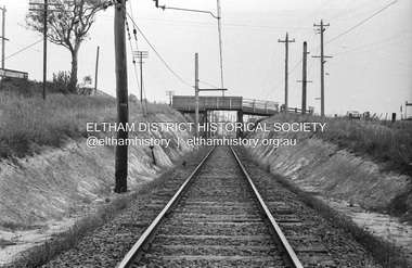 Eltham District Historical Society Inc
Photograph, Railway overpass on Sherbourne Road at junction of Para Road and Simms Road, Briar Hill, 3 November, 1967
Viewed from railway line opposite Graham Body Works. Simms Road is running to the right in front of the old house. The house belongs to Mrs Cameron whose daughter married a DAVEY after which Davey Street is named. Excavation work is being undertaken for the realignment of the Para Road and Sherbourne Road intersection where the current roundabout is located, approximately where the two cars are parked. Mrs Cameron's house and the other are where Montmorency Secondary College is situated. The school opened in 1969.Roll of 35mm black and white negative film, 6 strips Ilford HP3briar hill, cameron, davey, davey road, graham body works, greensborough, montmorency secondary college, sherbourne road, simms road