Showing 171857 items
matching streets
-
 Kew Historical Society Inc
Plan, Melbourne & Metropolitan Board of Works : Borough of Kew : Detail Plan No.1572, 1905
The Melbourne and Metropolitan Board of Works (MMBW) plans were produced from the 1890s to the 1950s. They were crucial to the design and development of Melbourne's sewerage and drainage system. The plans, at a scale of 40 feet to 1 inch (1:480), provide a detailed historical record of Melbourne streetscapes and environmental features. Each plan covers one or two street blocks (roughly six streets), showing details of buildings, including garden layouts and ownership boundaries, and features such as laneways, drains, bridges, parks, municipal boundaries and other prominent landmarks as they existed at the time each plan was produced. (Source: State Library of Victoria)This plan forms part of a large group of MMBW plans and maps that was donated to the Society by the Mr Poulter, City Engineer of the City of Kew in 1989. Within this collection, thirty-five hand-coloured plans, backed with linen, are of statewide significance as they include annotations that provide details of construction materials used in buildings in the first decade of the 20th century as well as additional information about land ownership and usage. The copies in the Public Record Office Victoria and the State Library of Victoria are monochrome versions which do not denote building materials so that the maps in this collection are invaluable and unique tools for researchers and heritage consultants. A number of the plans are not held in the collection of the State Library of Victoria so they have the additional attribute of rarity.Original survey plan, issued by the MMBW to a contractor with responsibility for constructing sewers in the area identified on the plan within the Borough of Kew. The plan was at some stage hand-coloured, possibly by the contractor, but more likely by officers working in the Engineering Department of the Borough and later Town, then City of Kew. The hand-coloured sections of buildings on the plan were used to denote masonry or brick constructions (pink), weatherboard constructions (yellow), and public buildings (grey). Plan No. 1572 represents the built environment bordered by Barkers Road, Wrixon Street, Edgevale Road and Fitzwilliam Street. Other streets identified on the plan include Stansell Street. Plan 1572 shows that by 1903-05, there was only patchy development in this area of Kew, mainly on Edgevale Road and Fitzwilliam Street. Only two named houses are identified: the quaintly named ‘Tweed Cottage’, and ‘Mendip’. The earliest reference to Treed Cottage in Australian newspapers is to the death of Walter Thompson, aged 74 who was a resident there in 1885. His youngest daughter was to die there in 1908. Mendip to the north of Tweed Cottage was owned by Henry Thompson; he was to die in 1901; his wife in 1932. At this period of time, Malin Street and Clivedon Court did not extend to Barkers Road.melbourne and metropolitan board of works, detail plans, mmbw 1572, cartography -
 Bendigo Historical Society Inc.
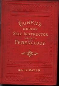
Book - COHEN'S MODERN SELF INSTRUCTOR IN PHRENOLOGY
271 page hardcover titled 'The Modern Self Instructor in Phrenology, Physiognomy and physiology or The Peoples Hand book of Human Nature. Red in colour with gold print.The first page is yellow paper which has a hand written note in black ink which reads: 'Presented to Henry Gough by his teacher A. Hampson for obtaining the highest number of marks during 1887 in his class at St. Paul's Sunday School dated 1/04/88. The book is Cohen's view into the mind, body, and sole of human beings.Gustavus Cohen. George Whitehead & Sons, Printers, New Street & Kings Street, Huddersfield.medicine, mental health, phrenology, henry gough, a. hampton -
 Warrnambool and District Historical Society Inc.
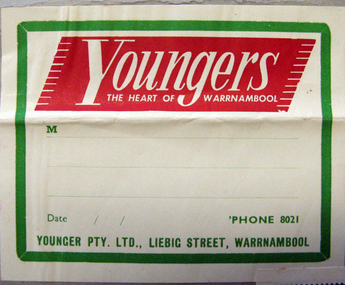
Label, Youngers, Early 20th century
John Younger came to Warrnambool from Yackandandah in 1888 originally with a partner John Jeffrey and opened a store selling general merchandise. In 1914 a new company known as Younger PTY LTD. was formed. The business grew into a large department store in Liebig Street. In 1958 the business was sold to Charles Moore and continued trading as Youngers. The store closed in 1980This label is an important memento of one of the key businesses in Liebig Street, Warrnambool in the 20th century. Younger stores are credited with making Liebig Street the main street in this city.White paper label with red and green printing adhered to a piece of grey cardboard. There is another label on the same card.Youngers THE HEART OF WARRNAMBOOL YOUNGER PTY. LTD.,LIEBIG STREET,WARRNAMBOOL M date 'PHONE 8021 youngers warrnambool -
 Port Melbourne Historical & Preservation Society
Photograph - Four men outside a house, Station Street, Port Melbourne, 1800s
Photographic copy of a photograph of a house in Station Street with four men in front. All wear shirts and hats, three wear jackets, two of these have ties, the other a scarf. The coatless man appears to have a corncob pipe in his mouth. These men are related to the Smith family, one of them being the house owner who is married to a Smith girl. Large tree visible on left, and a tree behind the distinctive picket fence. Date is unknown; probably 1800s.Photo has been mounted, velcoo's and marked in felt pen 'copy of photo belonging to Margaret Couch, Princes Street'.built environment - domestic, families, margaret smith couch -
 Stawell Historical Society Inc
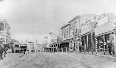
Photograph, Upper Main Street Stawell looking East with on left the 2 story Allingham building & behind the cart is the Commercial Hotel c1910 -- 2 Photos -- 1 Colour
Upper Main Street Stawell. Looking East c1910. On left two story Allingham building behind cart is Commercial Hotel. Oriental Bank. Punchard Furniture. Crown Cross Poppet head visible on Big Hill. The side of the Mechanics Institute visible near centre. H S Dawson Chemist. Clarke & Scott Drapery on right. Same as 6730-1 & 2785View along upper Main Street looking East towards Big Hill. Poppet Head in distance at centre.stawell streetscape, mining -
 Ringwood and District Historical Society
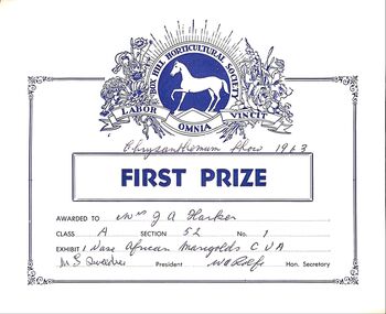
Certificate, Two First Prize Certificates awarded to Mrs. Ruby Harker at Box Hill Horticultural Society Chrysanthemum Show in 1963
Ruby Harker was Amy Thelma Wielands sister. The Certificates are in an envelope addressed to Mre. J.A. Harker 16, B, Churchill street , Mont Albert. Ruby's sister also lived in Churchill Street at one time after their house in Heathmont burnt down..2 buff coloured Cards with blue printing and the Box hill Horicultural Society crest at top. In a brown envelope with he address 16 B Churchill Street , Mont Albert. E 10. No post mark. -
 Stawell Historical Society Inc
Photograph, Mechanics Institute in Upper Main Street Stawell 1970 -- Coloured and Black & white copies
Mechanics Institute Main Street Stawell. Used for many years as the library. Colour photo c1970s. Built in 1875 after the previous institute was damaged by fire in 1874. Architect Mr. George Inskip. Previous wooden institute destroyed by fire in 1866. McKellar Building in background. Hairdresser and Grampians real estate signs visible.Angle on photograph of Mechanics Institute Building. Cars parked in street in Foreground. Hairdresser and Grampians real estate signs visible.Mechanics Institute 1875stawell streetscape -
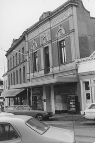
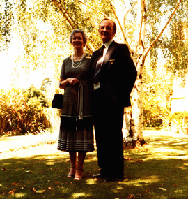 Ballarat Heritage Services
Photograph - digital copy, Jack and Kathllen Gervasoni Mayor and Mayoress of Kew 1979-80 at Chellowdene, 1979
Chellowdene was an architect designed triple fronted 1950s brick dwelling with an Edna Walling garden at 37 Wills Street, Kew. It was demolished by the subsequent owner.Copy of a colour photograph showing City of Kew Mayor John H. Gervasoni and Mayoress Kathleen Gervasoni in the front of their Kew property 'Chellowdene', 37 Wills Street, Kew. mayor, mayoral, portrait, kew, gervasoni, john, jack, k, mayoress, chellowdene, wills, kew mayors, wills street kew -
Port Melbourne Historical & Preservation Society
Document - Specification, Metalling and chanelling, Boundary Street South, Graham Street to St Vincents Street, Arthur Victor Heath, Town Clerk et al, 14 Mar 1893
Specifications (Reg. 77.1) and plan (Reg 77.2) for metalling and channelling Boundary Street South [Pickles Street] from Graham Street to St. Vincents Street. Loan works 1893, plan No. 5.A.V. Heath (Town Surveyor):J.J. Bartlett (Mayor)engineering - roads streets lanes and footpaths, town planning, town clerks, mayors, arthur victor heath, james john bartlett -
Port Melbourne Historical & Preservation Society
Plan - Metalling and chanelling, Boundary Street South, Graham Street to St Vincents Street, 14 Mar 1893
Specifications (Reg. 77.1) and plan (Reg 77.2) for metalling and channelling Boundary Street South [Pickles Street] from Graham Street to St. Vincents Street. Loan works 1893, plan No. 5.J.J. Bartlett (Mayor) 14/3/93engineering - roads streets lanes and footpaths, town planning, town clerks, mayors, arthur victor heath, james john bartlett -
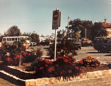 Stawell Historical Society Inc
Photograph, Car Park in Sloane Street looking towards Main Street Stawell c 1978 - Large coloured photograph
Colour photograph of Car Park Sloane Street looking towards Main Street Stawell. The car park was created when Main St. Stawell became a Pedestrian Mall c 1978Large coloured photograph taken from Sloane Street, looking towards Main St. The photo has a bus on the left hand side and cars in the car park. The photo is taken in front of a garden bed with a No Entry sign in the middle of the photograph.stawell -
Tatura Irrigation & Wartime Camps Museum
Photograph - copy, James Curtis Home, 1986
Photograph of home of James Curtis, corner Francis and Kerford Streets. Original home of J. H. Davey, proprietor of Tatura Guardian. Occupied by Mrs Jas. Curtis 1988.Black and white photograph of an early home in Tatura. Exterior.on back: home of James Curtis, corner Francis and Kerford Streets, 1986. Original home of J. H. Davey, proprietor Tatura Guardian.james curtis, tatura guardian, francis street tatura, kerford street tatura -
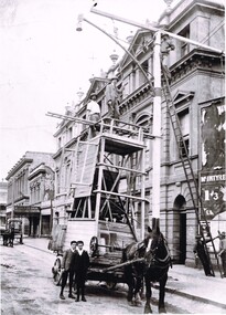 Ballarat Tramway Museum
Photograph - Positioning street lights - Lydiard St North, Ballarat late 1890s
Photo of the installation of an electric arc type street lamp in Lydiard St North, near the Provincial Hotel Ballarat. The tower wagon is drawn by a single horse. Two boys standing alongside while two men are on the top of the wagon, a man on the top of the ladder is positioning a lifting beam while two men on the ground hold the rope for this beam. On the side of the wagon is possibly an extension that could be lifted onto the top of the tower itself to give a greater working height. The buildings between Mair St and the railway station on the west side of Lydiard St North remain in position. Yields information about the methodology of the late 1890's to install street lighting in BallaratDigital print of a Positioning street lights Lydiard St North Ballarat late 1890sarc lamps, ballarat, lydiard st north, electric lighting, tower wagons, horses, workmen, street lights -
 Tatura Irrigation & Wartime Camps Museum
Photograph, Casey Street, Tatura
Shows site of old Sacred Heart School, corner of Frances and Casey Streets, Tatura. Shows back of St Mary's and Convent.Colour photograph showing site of old Sacred Heart School, Casey Streets, Tatura. Shows back of St Mary's and Convent. Photograph stuck onto piece of white cardboard. hogan street tatura, casey street tatura, sacred heart convent tatura, sacred heart college tatura -
Whitehorse Historical Society Inc.
Document, Certificate of Title - William McConville, 1903, 1929
Certificate of Title in the name of William McConvilleCertificate of Title in the name of William McConville re Lots 44 and 45 on the corner of Victoria Avenue and Albert Streets, Mitcham. Includes details of mortgage registered 16 Jul 1929.Certificate of Title in the name of William McConvillemcconville, william, land titles, shire of blackburn and mitcham, victoria avenue, mitcham, albert street, mitcham -
 Kew Historical Society Inc
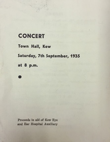
Programme - Concert Program, Concert, Town Hall, Kew, 1935
Program for a concert in the Walpole Street Town Hall in September 1935. The final page of the program includes advertisements for a draper and a chemist in HawthornFour page program for a concert in the Kew Town Hall, in Walpole Street, given on 7 September 1935. The proceeds of the concert were to be given to the Kew Eye and Ear Hospital Auxiliary.concerts - kew (vic) -
 Melton City Libraries
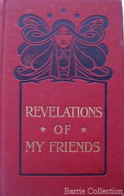
Book, 'Revelations of my friends', 1914
Rosemary Myers spoke about Lizzie Daley in May 2012. She described the house as having lots of ornaments, and how she enjoyed going thereto buy ribbons and laces for a pair of baby booties she knitted for her school handwork at Melton P S 430. Margaret Nolan's memories of Lizzie: When we were young kids we would go down to visit our cousins, the Myers who lived on the Highway. My great grand mother Mary Luby lived in Reserve road when she came to Melton, she was married here in 1857. Her sister Ann nee Dowling was married to Henri Miers [Myers] in 1867. Her other sister Eliza married William Daley in 1862. He had a Bootmakers shop in the High street. Their daughter Lizzie later turned it into a haberdashery shop. We would go there to buy sewing threads and ribbons. Margaret nee Nolan Brooks memories recorded on the 20th September 2013 Book was from Lizzie Daley's shop in High Street, Meltonlocal identities -
 Bacchus Marsh & District Historical Society
Photograph, Simpsons Butchery Main Street Bacchus Marsh 1883
John Simpson arrived in Bacchus Marsh around 1848. In 1850 he established a butchery business. He continued to operate this business in Main Street Bacchus Marsh until his death in 1890. His son John Simpson and one of his brothers, Edward took over the business and operated it until 1923. John Simpson the younger died in 1940 having lived all but a few months of his 92 years in Main Street Bacchus Marsh. Edward L. Simpson died in Corowa, NSW in 1937. The younger John Simpson's recollections of Bacchus Marsh in the 1850s to 1870s were published in the Bacchus Marsh Express on the 25 June 1932.Small sepia unframed photograph on card with gold border framing photograph. Housed in the album, 'Photographs of Bacchus Marsh and District in 1883 by Stevenson and McNicoll'. The image shows a butchery shop in Main Street Bacchus Marsh in 1883. The front of the building is shown. It is a solid brick or stone structure with a shingled roof and verandah. Hanging under the verandah are numerous carcasses and portions of meat. Two men are standing close together in front of the shop. One is wearing a butcher's apron. Another man to the left sits upon a horse. In the doorway behind the men stands a woman. On the front: Stevenson & McNicoll. Photo. 108 Elizabeth St. Melbourne. COPIES CAN BE OBTAINED AT ANY TIME. On the back: LIGHT & TRUTH inscribed on a banner surmounted by a representation of the rising sun. Copies of this Portrait can be had at any time by sending the Name and Post Office Money Order or Stamps for the amount of order to STEVENSON & McNICOLL LATE BENSON & STEVENSON, Photographers. 108 Elizabeth Street, MELBOURNE. stevenson and mcnicoll 1883 photographs of bacchus marsh and district, butcher shops, butchers, john simpson butcher 1848-1940, john simpson butcher died 1890 -
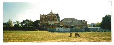
 Kew Historical Society Inc
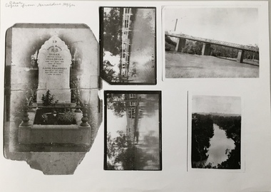
Photograph - Photocopy, Bryan Family Album, Twentieth Century
The Bryan family live din Princess Street, Kew.Photocopies of original photographs relating to or that belonged to the Bryan Family of Princess Street, Kew. The images include the headstone of Sarah Bryan and Anne Chambers; three photos of floods in Kew, one dated 1931; and a view of the River Yarra. bryan family (kew), kew -
Whitehorse Historical Society Inc.
Article, New workshop to go up in east
$200, 00 Mitcham property purchased to establish an industrial workshop complex for the handicapped of the eastern suburbs.$200, 00 Mitcham property purchased to establish an industrial workshop complex for the handicapped of the eastern suburbs. $38,000 was raised by NADRASCA. Property at Colombo Street, Mitcham. Federal grant provided bulk of the money.$200, 00 Mitcham property purchased to establish an industrial workshop complex for the handicapped of the eastern suburbs. disabled, nadrasca, colombo street, mitcham -
 Ballarat Heritage Services
Photograph - Photograph - Colour, Clare Gervasoni, Former Yandoit Hills School 2052 after being moved to Hepburn Springs, c2005, c2005
This building was moved from Yandoit Creek to the corner of Main Road and Seventh Street, Hepburn Springs. Colour photograph of on old schoolhouse that was moved from Yandoit Hills to the corner of Main Road and Seventh Street, Hepburn Springs. The building was used for religious services before being turned into a private residence. yandoit hills state school no 2052, education, hepburn springs, yandoit hills, yandoit creek -
Port Melbourne Historical & Preservation Society
Photograph - Nott Street State School Photograph, 1945
Class at Nott Street State School in 1945. The back has an attached label naming the pupils. Top Row L/R ?, A. CAMPBELL, J WATERSON, J ALLARD, A STOCKTON, D CLARK, D CLARK, W MURRAY, 2nd Row L/R ?, S GAY, C ERMEL, B JAMES, B CHRIMES, A EASTON, ? , W WHITE. 3rd Row L/R ?, J ELMSON, ? , J SAW, H DOWNER, ? , ? , B MORGAN, ?. 4th Row L/R ? , B KENT, F TAYLOR, ? , O MARSH, ? JENKINS, B MILLER, ? , H JACKSON. 5th Row L/R F POWER, G BENNET, F NICHOLSON, ? , B CAMPBELL, ?. Sepia photograph of 5 rows of children at Nott Street State School in 19451945 Nott Str No1427nott street state school, a. campbell, j waterson, j allard, a stockton, d clark, w murray, s gay, c ermel, b james, b chrimes, a easton, w white, j elmson, j saw, h downer, b morgan, b kent, f taylor, o marsh, ? jenkins, b miller, h jackson, f power, f nicholson, g bennet, b campbell -
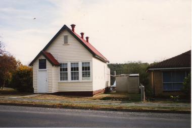
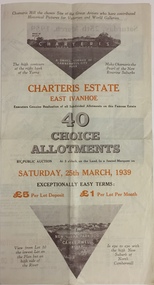 Kew Historical Society Inc
Plan - Subdivision Plan, Charteris Estate, East Ivanhoe, 1939
The Charteris Estate in Ivanhoe was sold in a number of sections. Copies of a subdivision plan of the first section is in the State Library of Victoria collection. This later section of the Charteris Estate includes lots in the Government Boulevard, Castella Street, McArthur Road, Burke Road North, Charteris Drive and Warncliff Road.Subdivision plans like that for the Charteris Estate are invaluable records for local historians identifying when lots in streets were promoted for sale.Four-fold brochure advertising the Charteris Estate in East Ivanhoe in 1939. Streets named on the plan include: the Government Boulevard, Castella Street, McArthur Road, Burke Road North, Charteris Drive and Warncliff Road. The brochure contains photos of Charterisville, the home of F De Castella Esq and also of attractive rolling hills. Annotations in pencilcharteris estate - east ivanhoe (vic), subdivision plans - east ivanhoe (vic) -
 Halls Gap & Grampians Historical Society
Photograph - B/W, Oct-86
This is part of a parade held on the main street of Halls Gap in conjunction with the 150th anniversary of Major Mitchell's visit to the area. The photo shows three young girls and a dog standing as part of a crowd lining a street. Buildings , including a souvenier and newsagents and a cafe, can be seen behind the crowd. There are trees in the far background.events, parades -
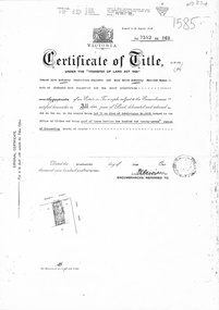 Whitehorse Historical Society Inc.
Document, Certificate of Title, 1/06/1951
Certificate of Title Vol 7583 Fol 060, being Lot 72 on Plan of Subdivision No 6626, 50 Burnett Street, Mitcham, with Plan of Subdivision No 6626 including Burnett Street, Thomas Street, bordered by Cook Street and Cook Street and Whitehorse Road, Mitchamburnett street, mitcham, no 50, thomas street, cook road, whitehorse road -
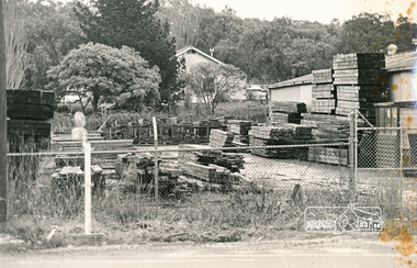 Eltham District Historical Society Inc
Photograph, N. J. Tillings Timber Factory, 15 June, 1975, 15/06/1975
Fence yard with piles of timber. Weatherboard building in background. This is one of 7 B/W 8x10 inch photos with notes on obverse by Dick Crichton. Accompanying letter from Florence Chrichton 2013 : "Originally sent to Shire of Eltham Engineer, Mr. McDonald. [These photographs were part of their campaign to the Shire of Eltham in 1975] claiming that the zoning regulations were being breached by the occupants of various factories in the nearby light industrial zone [Brougham Street, Eltham] - to the detriment of those living in adjoining residential zones, and that, despite .. earlier objections and complaints, nothing was done about it." 1 black and white photograph printed with white borderInscribed on back: "Ryans Yard, Susan Street, (part owned by Tillings) showing Tillings surplus baulk timber (at extreme right and left) before milling. This timber is often also stored in Peel Street. Majority of baulks are stored at rear or side of Tillings main premises. Eltham High School object to transportation of this timber along Bell and Susan Streets in large semi-trailers. Trucks backing in and out of Tillings cause frequent traffic jams in Bridge Street (often around 8am)." industrial estate, brougham street, eltham, 1975, bolton street, dick crichton, n.j. tillings, timber factory, shire of eltham, susan street, bell street, eltham high school -
Port Melbourne Historical & Preservation Society
Photograph - Graham Street Rockery
The rockery and buildings in this area of Graham Street were demolished in the 1970s when the Graham Street overpass was constructed.View of ornamental reserve (rockery) in Graham Street with many people, men, women and children standing in front of the rockery and a number of two-storey buildings in the background. The decorative lights of the Maskell & McNab Memorial are visible within the rockery. There is a bicycle leaning against the wall of the rockery at the centre of the image.graham street, parks and gardens, frederick william maskell, james mcnab, maskell & mcnab memorial -
 Bendigo Historical Society Inc.
Postcard - Alice McGregor Postcard Collection, 1900 - 1920
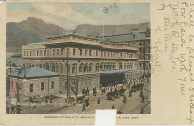
Alice McGREGOR Born: 1908; unknown parents. Possibly adopted by the Salter family? Electoral Roll 1936: Highland Terrace Kangaroo Flat. Alice Mary Salter and William Robert Salter living together; presumed to be sister and brother. William Robert Salter was killed in a MVA in Bendigo in 1937 aged 26. In Victoria in 1938, Alice Mary Salter married James Thomas McGregor (born Victoria 1917, died Victoria 1983, buried Fawkner Cemetery) Lived: 1968; 22 Wade Street Golden Square Alice McGregor Died: 1999 aged 91 at Anne Caudle Centre, Bendigo Buried: Kangaroo Flat Cemetery See additional research. Postcard Album of Alice McGregor contained 86 post cards.Postcard Album of Alice McGregor containing 86 post cards. See 1400 Colour photo of the Railway Station, Alderley Street, Cape Town, South Africa. Horse drawn vehicles and pedestrians on the street. kground Addressed to Miss A. Stapleton, Arcade, Bendigo, Victoria, Australia Sender - Mrs. E.R. De Low, Hex River, Cape Colony, S. Africa Not dated postcard, collector, alice mcgregor -
 Old Colonists' Association of Ballarat Inc.
Photograph - Photograph - Colour, Ballarat Old Colonists' Association Homes, Charles Anderson Grove, Ballarat
HISTORY OF THE BALLARAT OLD COLONISTS' ASSOCIATION HOMES AT CHARLES ANDERSON GROVE, LAKE GARDENS One of the original objectives of the Association was “to provide the shelter of a house for those Pioneers of the Goldfields whom the reverses of fortune have deprived of the means of procuring the comforts of life in their declining years.” While the first home at Charles Anderson Grove was built in 1925 the Association had previously provided relief for needy pioneers from the time it was formed in 1883. Relief included monthly monetary payments, loads of firewood, medical assistance and distribution of Christmas boxes of groceries to deserving pensioners and in some cases payment of burial costs. Records indicate that in September 1922 three of the pensioners being assisted by the Association were accepted as residents in the newly erected Hassell Homes in Gillies Street (now demolished-opposite the High School). The first site for an Asylum for Indigent Members of the Old Colonists' Association was temporarily reserved from sale in October 1891. The site was approximately 28 acres in area in Mt Clear nearly opposite Midvale Shopping Centre in Main Road. The site was heavily timbered and when cleared over 260 tons of wood was sold to the Woah Hawp Gold Mining Company. A set of gates were erected but no homes built, although a plan for this reserve was drawn which showed twenty buildings ranging from one to four unit per building. The reserve was revoked in November 1909. The second site temporarily reserved in November 1909 as an Asylum was in Alfredton and consisted of some 7 acres and was adjacent to land reserved for an Abattoirs for the Ballarat Council. The reserve was revoked in February 1912 as it was deemed more appropriate to be added to the Abattoir site. Council suggested four (4) other sites in exchange for this land and they were inspected by the President, Vice President and Secretary on 22 December 1912. The first site inspected was land on the west side of Creswick Road opposite the brick kilns (now occupied by the showgrounds and oval). The land was described as being good quality, well fenced, no trees, good drainage and ample acreage but some distance from trams. The second site was Perry Park which was described as being good land, well fenced, having frontage to Gillies Street, good drainage and about 26 acres (but subsequently reduced to 10 acres). It was closely planted with Pinus Insignias and Wattle and had easy access from the Botanic Gardens tram. The third site was the North West portion of Victoria Park (corner of Sturt and Gillies Street) and was described as good land, well fenced and drained and well located. The fourth site was the South West corner of Victoria Park and known as Pound Paddock (corner of Winter Street and Gillies Street). It was considered to be low lying and too close to the Abattoir, and was also a considerable distance from trams. While the third site was recommended as the most suitable for the erection of homes it was considered unwise from the point of view as citizens to reduce the acreage of the park and therefore it was recommended that the Perry Park site be asked for as the most acceptable to the Association for the building of homes. The site was eventually temporarily reserved for an Asylum for Indigent Members of the Association in April 1914 with the gates from Mt Clear having been removed to the site a year earlier and eventually erected in 1917 for £12.10.0. In the same year the first 290 pine trees were advertised for removal in July and sold for £16. A sign indicating that the site was reserved for the erection of cottages was erected in September 1917. Stripping of the wattle bark (for tanning) and the cutting of the wood occurred in November 1918 with the land then being leased until it was required for the construction of the first homes in 1924. While the site was the third to be reserved it was the only one which was used for its intended purpose. It was named as Charles Anderson Grove in honour of Charles Anderson who joined the Association in 1918 and was President of the Association from 1942 to 1944. A number of cottages in the Ballarat Old Colonists' Association Retirement Village of Gillies Street, Ballarat.charles anderson grove, old colonists' club, ballarat, old colonists' association, old colonists' homes, retirement village