Showing 3404 items matching " 2000.522..01"
-
 Hume City Civic Collection
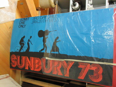
Ticket, Sunbury 73, 1/01/1973
The blue and black printed ticket was issued and used for the 2nd & 3rd days of the 1973 Sunbury Pop Festival. The Festival as held on the property of George Duncan at Diggers Rest on the banks of Jacksons Creek. It was held over the 3 days of the Australia Day Weekend in January. The 'smiley' stamp on the back of the ticket was used as a "passout" check. The tickets were collected by Nicholas Hall who worked as a Security Officer at one of the gates.A blue and black cardboard ticket printed for the 1973 Sunbury Pop Festival. The words Sunbury 73 are in large block letters across the bottom of the ticket and there are four silhouetted figures - 2 male and 2 female. One male is riding a bike and other male is carrying a double bass on his head. The two females are walking. There is a 'smiley' stamp on the back of the ticket."ADMIT 2nd & 3rd DAYS ONLY..."1970s, sunbury pop festival, duncan, george, george evans collection -
 Sunshine and District Historical Society Incorporated
Photograph (1950), The Migrant Ship HELLENIC PRINCE, Copy 27/01/2014 - (Original Post Card circa 1950)
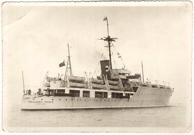
In 1949 the HELLENIC PRINCE with its 3 hospitals, 2 cinemas, and air conditioned accommodation was chartered by the International Refugee Organisation to transport displaced persons from Europe to Australia. Its first trip was to Sydney where it arrived with 1000 passengers on 5 December 1949. On the third trip it left Naples on 23 March 1950, and arrived in Fremantle on 20 April 1950, and in Melbourne on 25 April 1950. The men and women were separated for the voyage with my father sleeping on a hammock in a large room with other men, while my mother, my brother, and I had bunks in a shared cabin. On board were displaced persons ex Bagnoli Camp Italy, some of whom later built their bungalows on the grassy and rocky paddocks near Sunshine Victoria, and began to establish a new life in a new country. A few of the families that arrived on the third trip and purchased land in the Dunkeld Ave - Sandford Ave area of North Sunshine (Birmingham Estate) were Janczak, Kolanowicz, Mroz, Pawlak, Rasztabiga, Skrobalak, Szydlowski, Witkowski, and Zielinski. Some friends settled elsewhere in Sunshine. The family Tabaka went to West Sunshine just over the Derby Rd Bridge, while the family Wojcik went to Ardeer. The ship first started service in 1929 for the Royal Australian Navy as the HMAS ALBATROSS. It had a standard displacement of 4,800 tons and was 443 feet 7 inches (135.2 metres) long, and its top speed during trials reached 22 knots (41 km/hr). It was built at Cockatoo Island Dockyard as Australia's first Aircraft Carrier (seaplanes), but the aircraft that it was designed for were retired just before the ship went into service. A new plane specifically designed to work with the Albatross began operations after the ship was decommissioned in 1933, and placed into reserve in Sydney Harbour. Seaplanes continued to operate from the anchored ship. (Click on the Link 'HMAS Albatross (1)' situated above the Object Registration number to view pictures of the HMAS Albatross on the Navy web site). In 1938 the ship was recommissioned and transferred to the Royal Navy as part payment for the light cruiser Hobart. The ship then did military service for the Royal Navy during World War 2. It did patrol and escort duties in the southern Atlantic, and from mid 1942 in the Indian Ocean. By early 1944 the ship was converted so that it could repair landing craft and other support vessels off Sword and Juno beaches. The ship managed to return 132 craft into service and to save 79 others from total loss. On 11 August 1944 Albatross was torpedoed with the loss of either 50 or 66 personnel, but was able to be towed back to Portsmouth. After repairs she did a short service as a minesweeper depot ship, and following that was placed into reserve on 3 August 1945. In August 1946 the ship was sold for commercial use but the plans to convert it into a luxury liner or a floating cabaret fell through. The ship was again sold on 14 November 1948 to the British-Greek Yannoulatos Group, who renamed it HELLENIC PRINCE in recognition of the birth of Prince Charles and his Greek heritage. After conversion into a passenger ship the Hellenic Prince made several trips to Australia transporting displaced persons, however apparently not all trips were pleasant for the passengers. In the on board newsletter 'Kangaroo' dated 5 January 1951, the ship's master P. C. King expressed his indignation about the behaviour of passengers and made accusations of mutiny. According to some immigrants the conditions were appalling and overcrowded with 1200 passengers. Passengers were supposedly required to work and were paid with Woodbine cigarettes. The drinking water ran out, the freezer broke down, and fresh food that was brought on board went to the crew. Sea sickness was rife because the ship was rarely level due to malfunctioning pumps. (The newsletter 'Kangaroo' can be viewed at the Museum Victoria web site by clicking the Link 'Newsletter - Kangaroo'). In 1953 during the Mau Mau uprising the Hellenic Prince was used to transport troops to Kenya, and in 1954 the ship came to an end in a scrap yard at Hong Kong. THE ABOVE INFORMATION WAS COMPILED FROM; (1) http://en.wikipedia.org/wiki/HMAS_Albatross_(1928) (accessed 11/2/2013), (2) An article by Graeme Andrews found at http://www.afloat.com.au/afloat-magazine/2011/july-2011/The_boat_people_of_the _forties_and_fifties#.UuYY6ou4apo (accessed 27/1/14), (3) http://museumvictoria.com.au/collections/items/273166/newsletter-kangaroo-hellenic-prince-5-jan-1951 (accessed 27/1/14), (4) National Archive search starting at; www.naa.gov.au/collection/search/index.aspx (accessed 27/1/14), (5) http://www.flickr.com/photos/41311545@N05/3864781978 (accessed 29/1/14). Hellenic Prince has a significance to Sunshine Victoria because some of the displaced people from Europe, who arrived in Melbourne on Anzac Day 1950, were among the first people to settle in the grassy and rocky paddock areas of North Sunshine. These settlers established a residential suburban area out of the paddocks. In those early days there were no services and the planned roads were basically just drawings on a map. The ship is also significant because it was named in recognition of the birth of Prince Charles. In the ship's former life as the HMAS Albatross the significance is that it was built in Australia as our country's first Aircraft Carrier (seaplanes).New photograph made from a scanned copy of a circa 1950 Post Card featuring the ship on calm water.Hellenic Prince / Hong Konghellenic prince, migrant ship, displaced persons, refugees, international refugee organisation, bagnoli camp, hmas albatross, yannoulatos group -
 Melbourne Athenaeum Archives
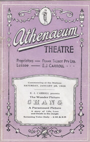
Theatre Program, Cass & Clothier (Printers), Chang (film) : A Drama of the Wilderness screened at the Athenaeum Theatre in 1928, 28/01/1928
The last silent film to be shown at the Athenaeum Theatre presented by E J Carroll. The theatre was managed by Frank Talbot Pty Ltd during his long lease of the theatre following his major renovations when Henry White the architect built an intimate theatre inside the old Athenaeum Hall. In addition to musical accompaniment for the film, the orchestra, and sometimes singers entertained audiences before the films commenced and during interval. Filmed on location in the jungles of Siam (Thailand). Programs, printed for early films at the Athenaeum Theatre provided the full program for the audience in the centre pages and gave background information about the story and the actors. Chang was the last silent film to be shown at the Athenaeum Theatre before the Jazz Singer changed cinema going for ever with the introduction of both vocal and musical sound. No longer was the cinema orchestra required to provide atmosphere thus changing the cinema experience forever.Paper program of 20 pages presenting the Paramount Picture "Chang". The program Includes articles about the film, advertisements, movie stills, movie review, cast and illustrations. athenaeum theatre, program, programme, silent film, chang, frank talbot pty ltd, e j carroll, paramount pictures, athenaeum operatic orchestra, mr bobbie pearce -
 Clunes Museum
Photograph, Jul-01
WATER TANK WAS BUILT TO HOLD WATER FOR THE FIRE BRIGADE BEFORE RETICULATED WATER3 COLOURED PHOTOGRAPHS SEWERAGE INSTALLATION - DISCOVERY OF FIRE BRIGADE WATER TANKlocal history, photography, photographs, sewerage installation -
 Clunes Museum
Photograph, Jul-01
MODEL MADE BY CARL NORDSTROM ON THE PORT PHILLIP MINE SITE IN 1858. NOW ON DISPLAY AT THE SCIENCE MUSEUM IN MELBOURNE *No longer on display, now archived. ON LOAN TO THE CLUNES COMMUNITY DURING THE 150TH GOLD CELEBRATIONS IN JULY, 2001, AND DISPLAYED IN THE ALL PURPOSE ROOM AT CLUNES PRIMARY SCHOOL.4 COLOURED PHOTOGRAPHS OF THE PORT PHILLIP MINE MODELlocal history, photography, photographs, mining -
 Clunes Museum
Newspaper - NEWSPAPER CUTTING, BALLARAT GAZETTE, 24/01/1973
NEWSPAPER CUTTING ABOUT THE POST OFFICElocal history, document, newspaper cutting, post office -
Clunes Museum
Magazine - BOOK / MAGAZINE, FPC. LIVING - A DIVISION OF EASTERN SUBURBS NEWSPAPERS, Aug-01
COLOURFUL MAGAZINE - AUSTRALIAN COUNTRY STYLE, CONTAINING ARTICLE -PAGE 90- BUILT ON GOLD. PHOTOGRAPH OF CLUNES TOWNSHIP, CEILING IN CLUNES TOWN HALL, MRS. PAT COOK IN FRONT OF CLUNES TOWN HALL.local history, books, magazine -
Clunes Museum
Work on paper - PAMPHLET, 10/01/2001
BIBLE CHRISTIAN BACKGROUND COMPILED BY TRAVIS McHARG. THE BIBLE CHRISTINANS WERE A MINOR METHODIST CHURCH, PRIOR TO THE AUSTRALIAN UNION OF AUSTRALASIAN METHODIST CHURCH SINCE SUBSUMED INTO THE UNITING CHURCH IN AUSTRALIA IN 1975.PHOTOCOPY OF THE HISTORY OF THE BIBLE CHRISTIAN CHURCH - CLUNES.A FEW NOTES ON THE EARLY YEARS.local history, religion, christian, churches, christian -
Clunes Museum
Newspaper - NEWSPAPER CUTTING, BALLARAT GAZETTE, 24/01/1973
DOCUMENT / CUTTINGlocal history, document, newspaper cutting, longstaff, sir john -
 Plutarch Project
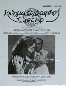
Film magazine, Κινηματογραφικός Αστήρ, 18/01/1959
This magazine was first published in January 1959 and was a fortnightly edition which was distributed for free. The story is that in May 1963 at the National Theatre in Richmond when the film titled "KRYSTALLO" ("Κρυστάλλω") was about to be screened for the first time "Cosmopolitan Motion Pictures" thought of a very unique way of promoting it. Apart from the usual publications to the "Kinimatografikos Astir" (Film Star) magazine and the flyers, they decided to display on the theatre roof 25 live sheep in a scene from a typical Greek village stable with a shepherd etc. They also assigned the task of creating a large banner sized 2 metres by 8 meters approx. to an Australian artist (name unknown) to adorn the front of the National Theatre. When these sheep and the banner were finally displayed before the first screening there was so much traffic congestion created in front of the theatre that it became a standstill. Very quickly the police was informed and the RSPCA who attended and ordered the organisers to dismantle the setup of sheep on the roof as it was considered cruelty to the animals and that it was organised without a proper license. Nevertheless the film had so much success, that it was unprecedented for the times. First showing was 9th May 1963Primary historic significance to the Greek Film and Entertainment industries in Australia. Secondary Social and Rarity publication significance.Bi-weekly magazine size A4, published in black and white by "Cosmopolitan Motion Pictures" for the purposes of film shows and distributed free of charge."Κινηματογραφικός Αστήρ" magazine, entertainment, film, greek, language, publication, plutarch, yiannoudes -
Whitehorse Historical Society Inc.
Pamphlet, The story of the White Horse - the symbol of a city, 1/01/1996 12:00:00 AM
Brochure telling the history of the Whitehorse Hotel 1853-1921 and of the statue. Rev ed.Brochure telling the history of the Whitehorse Hotel 1853-1921 and of the statue. Rev ed.Brochure telling the history of the Whitehorse Hotel 1853-1921 and of the statue. Rev ed.white horse hotel, city of whitehorse -
Whitehorse Historical Society Inc.
Letter - Correspondence, Rate collection, 01/08/09/1933
Correspondence between Shire of Blackburn and Mitcham and the State savings Bank of Victoria re houses and lots 40 and 41.Correspondence between Shire of Blackburn and Mitcham and the State savings Bank of Victoria re houses and lots 40 and 41.Correspondence between Shire of Blackburn and Mitcham and the State savings Bank of Victoria re houses and lots 40 and 41.holt, john j., state savings bank of victoria, deakin street, mitcham lots 40 / 41, rates, shire of blackburn and mitcham -
 Whitehorse Historical Society Inc.
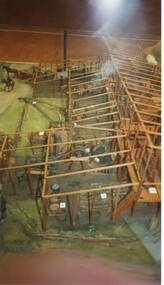
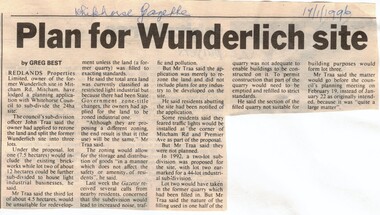
Article, Plan for Wunderlich site, 17/01/1996 12:00:00 AM
Wunderlich site in Mitcham Road,Article in Whitehorse Gazette re subdivision and rezoning of the former Wunderlich site in Mitcham Road, Mitcham.Wunderlich site in Mitcham Road,land subdivision, redlands properties, wunderlich limited, mitcham road, mitcham -
 Whitehorse Historical Society Inc.
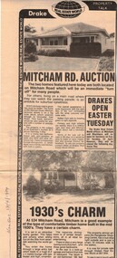
Newspaper, Mitcham Road auction, 01/04/1984,Nunawading
Advertisement for the sale of two homesAdvertisement for the sale of two homes, 265 Mitcham Road, Mitcham and 534 Mitcham road, Mitcham a 1930s timber home. Agent, drakes real estate. Photographs. Cutting from Nunawading Gazette, 18th April, 1984.Advertisement for the sale of two homesmitcham road, mitcham, no. 534, mitcham road, mitcham, no. 265, houses, drake & co. -
 Whitehorse Historical Society Inc.
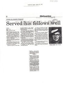
Newspaper - Article, Served His Fellows Well, 1/01/1997
Obituary of Vivian Glyndwr (Glyn) Francis.Obituary of Vivian Glyndwr (Glyn) Francis. He grew up in Daylesford and was an army cook in World War 2 and later ran a catering business. A note is attached stating that he was the father of Barbara Rogalski and that he catered for the opening of Schwerkolt Cottage. Classified death notices are included. Photograph . From Herald Sun Friday, January 24, 1997Obituary of Vivian Glyndwr (Glyn) Francis. francis, vivian glyndwr -
 Whitehorse Historical Society Inc.
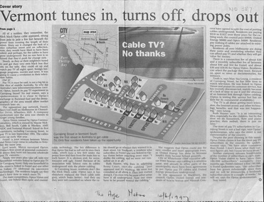
Newspaper - Article, Vermont tunes in, turns off, drops out, 01/06/1997
Residents in Currajong Street, Vermont South initially join up with either Foxtel, Galaxy or Optus but have since been disconnected with the exception of four houses. Some residents in Blackburn are paying to have cables put undergroundtelevision broadcasting, galaxy, foxtel, optus vision, currajong street, vermont south, remy court, acacia avenue, blackburn, waratah crescent, danene court, seamer, peter -
 Whitehorse Historical Society Inc.
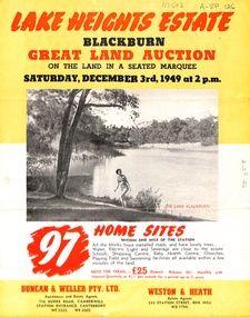
Document, Lake Heights Estate, 01/11/1949
Auction brochure for 'Lake Heights Estate' Blackburn. 97 blocks, 3 December 1949. Agents in conjunction, Duncan & Weller Pty Ltd and Weston & Heath.land subdivision, lake road, blackburn, lake heights estate, florence street, nunawading, clifton street, gerald street, milton street -
 Whitehorse Historical Society Inc.
Document, Canterbury Road Tunstall, 29/01/19?5
Photocopy of letter to the Commercial Bank, Prahran re land and property valuation occupied by Mr Sliegner, north side of Canterbury Road, Tunstall (Now Forest Hill) close to Springvale Road. Land 2.5 acres with villa and out buildings.land values, sliegner (mr), canterbury road, forest hill, c. husband (estate agent) -
Whitehorse Historical Society Inc.
Pamphlet, Margaret White, 1/01/2004 12:00:00 AM
Order of service for thanksgiving celebration for the life of Margaret White (1915 - 2004) at St John's Catholic Church, MitchamOrder of service for thanksgiving celebration for the life of Margaret White (1915 - 2004) at St John's Catholic Church, MitchamOrder of service for thanksgiving celebration for the life of Margaret White (1915 - 2004) at St John's Catholic Church, Mitchamwhite, margaret, st johns catholic church, mitcham -
Whitehorse Historical Society Inc.
Document, Grand Carnival, Morton Park, Blackburn, 28/01/1928 12:00:00 AM
Official program of the annual Morton park Blackburn grand carnival.Official program of the annual Morton park Blackburn grand carnival.Official program of the annual Morton park Blackburn grand carnival.blackburn, morton park, festivals and celebrations -
Whitehorse Historical Society Inc.
Document, Grand Carnival, Morton Park, Blackburn, 26/01/1929 12:00:00 AM
Official program of the 2nd annual grand carnival held at Morton Park, BlackburnOfficial program of the 2nd annual grand carnival held at Morton Park, BlackburnOfficial program of the 2nd annual grand carnival held at Morton Park, Blackburnblackburn, morton park, festivals and celebrations, athletics, cycling -
Whitehorse Historical Society Inc.
Map, Blackburn, 13/01/1977 12:00:00 AM
Enlarged aerial photograph of Blackburn Business Centre. Scale 1:150 metric.Enlarged aerial photograph of Blackburn Business Centre. Scale 1:150 metric.Enlarged aerial photograph of Blackburn Business Centre. Scale 1:150 metric.blackburn, blackburn road, blackburn, south parade, blackburn, railway road, blackburn, maroondah highway, blackburn, whitehorse road, blackburn, chapel street, blackburn, albert street, blackburn, queen street, blackburn, station street, blackburn, blackburn railway station, blackburn primary school, no. 2923, aerial photographs -
Whitehorse Historical Society Inc.
Document, Nunawading Historical Society - Australia Day Exhibition 1988, 1/01/1988 12:00:00 AM
Australia's Bicentennial Year, by the Nunawading Historical Society.Headings and information used for a display in the Nunawading arts centre on Australia Day 1988, Australia's Bicentennial Year, by the Nunawading Historical Society. Headings: Tribal Meeting Place; Pioneers; Land Boomers and Orchardists; Between the Wars; Suburban Sprawl.Australia's Bicentennial Year, by the Nunawading Historical Society.nunawading historical society, australia day, festivals and celebrations -
Whitehorse Historical Society Inc.
Document, Australia Day Family Festival - 1982, 26/01/1982 12:00:00 AM
City of Nunawading Commemorative Envelope issued to mark the Australia Day Family Festival, 1982City of Nunawading Commemorative Envelope issued to mark the Australia Day Family Festival, 1982City of Nunawading Commemorative Envelope issued to mark the Australia Day Family Festival, 1982australia day, city of nunawading, festivals and celebrations -
Whitehorse Historical Society Inc.
Document, Australia Day Festival - 1987, 26/01/1987 12:00:00 AM
Program for the Nunawading Australia Day Family festival, Monday 26 Jan 1987.Program for the Nunawading Australia Day Family festival, Monday 26 Jan 1987.Program for the Nunawading Australia Day Family festival, Monday 26 Jan 1987.australia day, city of nunawading, festivals and celebrations -
Whitehorse Historical Society Inc.
Document, Australia Day Family Festival - 1993, 26/01/1993 12:00:00 AM
Program of Nunawading Australia Day Family Festival. Tuesday 26 Jan 1993Program of Nunawading Australia Day Family Festival. Tuesday 26 Jan 1993Program of Nunawading Australia Day Family Festival. Tuesday 26 Jan 1993city of nunawading, australia day, festivals and celebrations -
Whitehorse Historical Society Inc.
Document, Nunawading Australia Day Family Festival 1992, 26/01/1992 12:00:00 AM
Program of the Australia Day Family Festival, 26 Jan 1992Program of the Australia Day Family Festival, 26 Jan 1992Program of the Australia Day Family Festival, 26 Jan 1992city of nunawading, australia day, festivals and celebrations -
Whitehorse Historical Society Inc.
Document, Australia Day Family Festival 1996, 26/01/1996 12:00:00 AM
The City of Whitehorse presents the Australia Day Family Festival, 26 Jan 1996 4 00 pm - 10.00 pm at the Nunawading Civic Centre Grounds - Program of events.The City of Whitehorse presents the Australia Day Family Festival, 26 Jan 1996 4 00 pm - 10.00 pm at the Nunawading Civic Centre Grounds - Program of events.The City of Whitehorse presents the Australia Day Family Festival, 26 Jan 1996 4 00 pm - 10.00 pm at the Nunawading Civic Centre Grounds - Program of events.city of whitehorse, australia day, festivals and celebrations -
Whitehorse Historical Society Inc.
Document, Australia Day Family Festival, 26/01/1995 12:00:00 AM
The City of Whitehorse presents the Australia Day Family Festival, Thursday 26 Jan 1995, Nunawading Civic Centre - Program of events.The City of Whitehorse presents the Australia Day Family Festival, Thursday 26 Jan 1995, Nunawading Civic Centre - Program of events.The City of Whitehorse presents the Australia Day Family Festival, Thursday 26 Jan 1995, Nunawading Civic Centre - Program of events.city of whitehorse, australia day, festivals and celebrations -
Whitehorse Historical Society Inc.
Document, The new City of Whitehorse, 1/01/1995 12:00:00 AM
The City of Whitehorse is one of 23 suburban municipalities created by the State Government's Local Government reforms.The City of Whitehorse is one of 23 suburban municipalities created by the State Government's Local Government reforms. It was formed by the amalgamation of Box Hill and Nunawading. This document lists its combined facilities.The City of Whitehorse is one of 23 suburban municipalities created by the State Government's Local Government reforms.city of whitehorse, city of nunawading, city of box hill, amalgamations