Showing 19558 items matching " east"
-
 Ringwood and District Historical Society
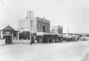
Photograph, Maroondah Highway Central, Ringwood. Main Street shops looking east from near station entrance, c1921
Black and white photograph(2 copies- 1 large, 1 smaller)Written below photograph, "Main Street Shops". -
 Ringwood and District Historical Society
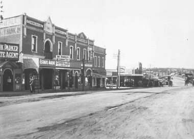
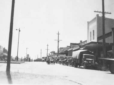
Photograph, Maroondah Highway Central, Ringwood. Looking east towards Adelaide Street and Warrandyte Road, 1918
Black and white photograph (3 copies- 2 large, 1 small).Typed below one large photograph: "Maroondah Hwy. 1918. Taken from outside railway station looking towards Warrandyte Rd." Image shows Coffee Palace and general store in middle, and Ringwood Post Office to the left. -
 Ringwood and District Historical Society
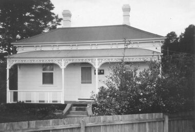
Photograph, The Ringwood East Presbyterian Church in Lois St
Written on back of photograph, "Rwd. E. Pres. Ch. Became coaching school, Lois St." -
 Ringwood and District Historical Society
Photograph, Committee Sacred Heart Fete, Ringwood East - c.1950, circa 1950
Committee Sacred Heart FeteWritten on photograph, "Committee Sacred Heart Fete" No people identified. Photo not dated. -
 Ringwood and District Historical Society
Photograph, Main Street shops looking east - Maroondah Hwy, Ringwood - 1935
Written on back of photograph, "Main Street, Ringwood". -
 Ringwood and District Historical Society
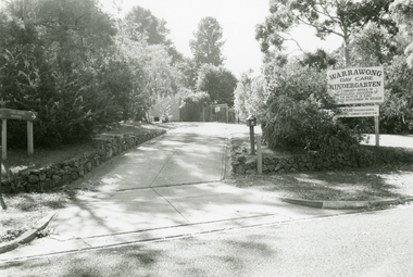
Photographs, Warrawong Kindergarten, East Ringwood in 1999
-
 Ringwood and District Historical Society
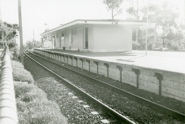
Photographs, Ringwood East Railway Station in 1999
-
 Ringwood and District Historical Society
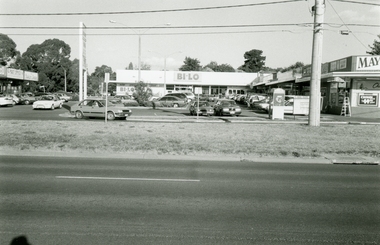
Photographs, Burnt Bridge Shopping Centre, East Ringwood in 1999
-
 Ringwood and District Historical Society
Photographs, Ringwood East Railway Crossing on Dublin Road in 1999
-
 Ringwood and District Historical Society
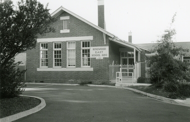
Photograph - Photographs, Ringwood East State School 4180 in Everard Road in 1999
-
 Ringwood and District Historical Society
Photographs, Holy Trinity Church, Paterson Street, East Ringwood in 1999
-
 Ringwood and District Historical Society
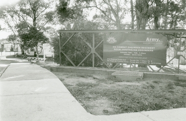
Photographs, Army Depot, Dublin Road, East Ringwood in 1999
4th Combat Engineer Regiment, Royal Australian Engineers -
 Ringwood and District Historical Society
Photographs, Old Lilydale road, East Ringwood in 1999
-
 Ringwood and District Historical Society
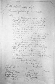
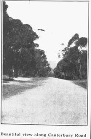
Photograph, Petition 4/9/1872 for road to Melbourne from "Blood's Hill" (eventual corner of Bedford Road and Dublin Road, Ringwood East). Canterbury Road was later extended as a result of the petition
Catalogue card reads, 'Petition 4/9/1872 "for road to Melbourne". -
 Ringwood and District Historical Society
Photograph, Image used for land sale promotion of Coleman's Heathmont Estate, looking east along Canterbury Road, Heathmont, towards Bedford Road. Sale 15/12/1923 by Public Auction
Written on back of photograph, "Coleman's Heathmont Estate, looking towards Bedford Rd. Sale 15/12/1923 by Public Auction". -
 Ringwood and District Historical Society
Photograph, Bedford Road,Ringwood East, looking west from outside No.128. (House far left is No.126) - 1/9/74
Written on back of photograph, "Bedford Rd. looking west from outside No.128. (House far left is No.126 as in brochure. 1/9/74)" -
 Ringwood and District Historical Society
Photograph, Lot 66 (No.5) Howard Ave, Ringwood East, taken from backyard of Lot 67 (No.3) - 1/9/1974
Written on back of photograph, "Lot 66 (No.5) Howard Ave. Taken from in backyard of Lot 67 (No.3) (8' off ground). 1/9/1974". -
 Ringwood and District Historical Society
Photograph, Image used for land sale promotion of Coleman's Heathmont Estate, looking east along Canterbury Road, Heathmont. Sale 15/12/1923 by Public Auction
Catalogue card reads, "Coleman's Heathmont Estate - 1923. Sale 15/12/1923." -
 Ringwood and District Historical Society
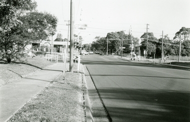
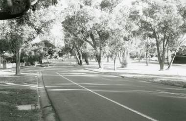
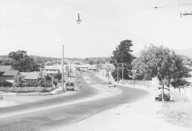
Photograph, Maroondah Highway West, Ringwood- 1969. Looking east from Heatherdale Road
Black and white photographWritten on back of photograph: "May, 1969" -
 Ringwood and District Historical Society
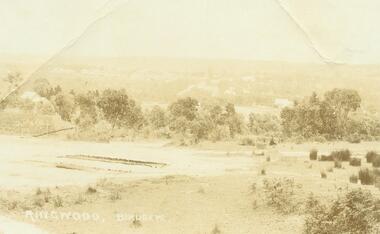
Photograph, Ringwood Birdseye - Looking towards Ringwood from later site of Civic Centre in Braeside Avenue, Ringwood East
Typed below photograph, "Looking towards Ringwood from present site of Civic Centre. Old Catholic Church which stood on Maroondah Hwy. and Mt. Dandenong Rd. intersection can be seen on right. Maroondah Hwy. can be seen where it goes past lake, also station masters residence, and houses in Pitt St. and Bedford Rd." -
 Ringwood and District Historical Society
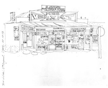
Photograph, Hand drawn picture by Eric Thake dated 1954 depicting Milne's Post Office and Store on the south-east corner of Oban Road and Warrandyte Road, North Ringwood
Typed below picture, "Mr. K. Milnes store. Corner Oban Rd. and Warrandyte Rd. 1954. Now demolished". -
 Ringwood and District Historical Society
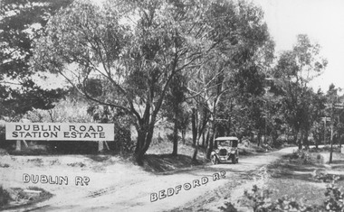
Photograph, Corner Dublin and Bedford Rds. Ringwood East, 10/11/19. Bloods Estate Sale
Typed below photograph, "Corner Dublin and Bedford Rds., 10/11/19". Written on back of photograph, "Bloods Estate Sale". -
 Ringwood and District Historical Society
Photograph, Maroondah Highway West, Ringwood- 1960. Looking east from Heatherdale Road
Black and white photographWritten on back of photograph: "Maroondah Highway coming into Ringwood, 1960". -
 Ringwood and District Historical Society
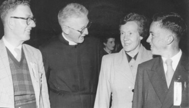
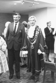
Photograph, City of Ringwood Chief Executive, Mr. Alan Robertson (left), and Mayor Cr. Bill Wilkins attending the opening of "Lionsbrae" aged care facility, Everard Road Ringwood East - 17/11/1985
Black and white photograph Mr. Alan Robertson (left), Mayor Cr. Bill Wilkins. Partly obscured Cr. Betty Milton. -
 Ringwood and District Historical Society
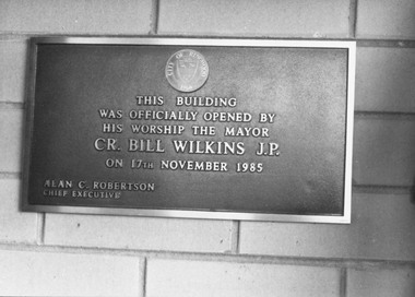
Photograph, Foundation stone at "Lionsbrae" aged care facility, Everard Road Ringwood East - 17/11/1985
Catalogue card reads, 'Foundation stone at "Lionsbrae", 17/11/1985'."This building was officially opened by His Worship The Mayor Cr. Bill Wilkins J.P. on 17th November 1985 - Alan C. Robertson Chief Executive" -
 Ringwood and District Historical Society
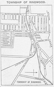
Photograph, Directory of Ringwood Township, from Sands and McDougall Directory - 1905. (New Street is incorrectly shown as Heatherdale Road on this map. Heatherdale Road's actual location is to the east, beyond the top of the map perimeter.)
Catalogue card reads, 'Directory of Ringwood Township - 1905. From Sands and McDougall Directory.' -
 Ringwood and District Historical Society
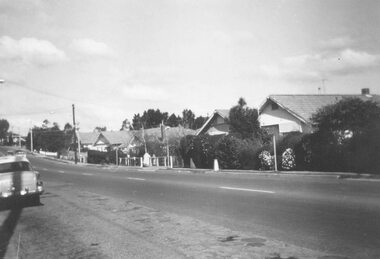
Photograph, Maroondah Highway West, Ringwood- c1920. Looking East from Heatherdale Rd
Black and white photograph (2 copies)Typed below photograph, "Maroondah Highway from Heatherdale Rd. Circa 1920". Written on backing sheet, "Whitehorse Rd. coming into Ringwood from Heatherdale Rd." -
 Ringwood and District Historical Society
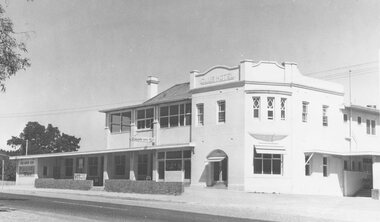
Photograph, Club Hotel, Mount Dandenong Road, East Ringwood in February 1960
Black and white photographs of Club Hotel February 1960 (1 original, three copies). The hotel has a long association with the Reddish family, thus given the name of "Daisy's Hotel". Included 2 copies of the photograph. Ryman Healthcare bought the site in 2019, including the garden supply business next door, making up a 2.2ha area. The proposal was for a $220 million retirement village to be built. The location is next to Ringwood Lake with the old hotel being knocked down in the early 2020s. -
 Ringwood and District Historical Society
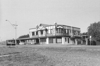
Photograph, Club Hotel, Mount Dandenong Road, Ringwood East 1973
Black and white photographs of Tudor style Club hotel -
 Ringwood and District Historical Society
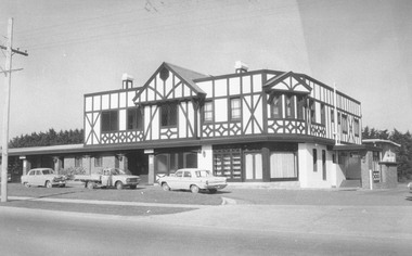
Photograph, Club Hotel, Mount Dandenong Road, Ringwood East in June 1971
Black and white photographs of Tudor style two-storey building (2 originals, 1 copy). The hotel has a long association with the Reddish family, thus given the name of "Daisy's Hotel". Included 2 copies of the photograph. Ryman Healthcare bought the site in 2019, including the garden supply business next door, making up a 2.2ha area. The proposal was for a $220 million retirement village to be built. The location is next to Ringwood Lake with the old hotel being knocked down in the early 2020s. Was H9 in old numbering system.Club Hotel June 1971