Showing 3272 items
matching little
-
 City of Moorabbin Historical Society (Operating the Box Cottage Museum)
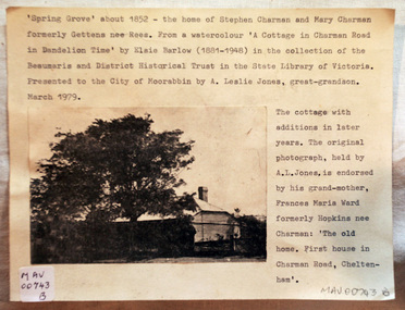
Document - Photograph, photocopy, of ‘Spring Grove’ 19th C house, Charman Road, Cheltenham, c1979
In 1852 Stephen Charman purchased 160 acres bounded by Charman Rd and Balcombe Road in an area called Spring Grove , later Cheltenham. A spring ran through the land providing a good source of water. Stephen aged 21 years had arrived in Melbourne 1842 as one of Henry Dendy’s emigrants . His Ship passage was paid by the Colonial Land and Emigration Commission and in return he was required to work on the land of the Henry Dendy Special Survey Brighton 1841. However Henry Dendy could not provide enough work for all the emigrants that arrived and Stephen had to obtain other work. Then sadly his young wife Harriett and their infant died. 1850 Stephen married widow Mary Gettens, a Publican in Little Collins Street, with 5 children. Stephen & Mary built a wattle and daub hut and established a market garden producing marigolds for Martin & Pleasance Pharmacists, Melbourne. They had 7 more children and built a weatherboard cottage that was used for early Methodist Church services. Stephen donated 1 acre to the Methodist Church in 1855 for Chapel , School and Cemetery. This is the weatherboard cottage in the photocopy showing the building extension, The road between Cheltenham and Mentone bears their name. Mary died in 1870 and Stephen remarried 1878 and died in Gippsland 1906. The original Photograph is endorsed by Francis Marie Ward , formerly Hopkins nee Charman who was the grandmother of Mr A.L Jones A photocopy of a black and white photograph of ‘Spring Grove’ , that was the first house in Charman Road , Cheltenham c1852 , showing later extensions. spring grove cottage 1852, schumer l, cheltenham, charman stephen, early settlers, jones a l, gettens mary, rees mary, charman mary, moorabbin, brighton, henry dendy special survey 1841, ward frances marie, charman frances marie -
 4th/19th Prince of Wales's Light Horse Regiment Unit History Room
Transmission Assembly, Ferret Scout Car, Daimler, c 1950
The Ferret Scout Car , was developed by the British Army in the late 1940s and came into production in the 1950s. The Ferret first saw service in the British Army in 1952, and a little later in Australia. There were many series and Marks of the Ferret. In Australia two were primarily used. The Mark1, which had no turret and a crew of three, and the Mark2, with a turret and a crew of two. The Australian Army used the Ferrets as scout cars until the 1960s, they were disposed of by public auction in the early 1970s. The Ferret is a light armoured car, intended for light reconnaissance work, they are very mobile and were well suited to their role. The vehicle was designed by Daimler, as a further development on the successful Daimler Dingo of WW2. The Ferret is fully armoured and the standard model of the Ferret Mk2 was further strengthened shortly after its design and became the Mk2/3 (this is the usual model referred as the Mk2). The motor was Roll Royce B60 motor, giving the vehicle a power to weight ratio of 29.35 break horse power per tonne, the vehicle weighs 3.6 tonnes, although a combat weight would be 4.3 tonnes. It is four wheel drive, constant, and has a top speed of 93 k.p.h. (approx 50 m.p.h.). Fuel consumption is only about 34 litres per kilometer. The Ferret is 3.8 metres long by 1.9 metres wide and is 1.9 metres high, not including radio aerials. The ground clearance is .33 of a metre and the track width is 1.5 metres.Ferret Scout Car - B60 No 1 Mk 6A transmission assembly incorporating engine, fluid coupling, gear box and transfer box.Engine Number 12993 List Number 35418 Modification plate marked to Mod 3. ferret scout car, transmission -
4th/19th Prince of Wales's Light Horse Regiment Unit History Room
Transmission Assembly, Ferret Scout Car
The Ferret Scout Car Mark 2, was developed by the British Army in the late 1940s and came into production in the 1950s. The Ferret first saw service in the British Army in 1952, and a little later in Australia. There were many series and Marks of the Ferret. In Australia two were primarily used. The Mark1, which had no turret and a crew of three, and the Mark2, with a turret and a crew of two. The Australian Army used the Ferrets as scout cars until the 1960s, they were disposed of by public auction in the early 1970s. The Ferret is a light armoured car, intended for light reconnaissance work, they are very mobile and were well suited to their role. The vehicle was designed by Daimler, as a further development on the successful Daimler Dingo of WW2. The Ferret is fully armoured and the standard model of the Ferret Mk2 was further strengthened shortly after its design and became the Mk2/3 (this is the usual model referred as the Mk2). The motor was Roll Royce B60 motor, giving the vehicle a power to weight ratio of 29.35 break horse power per tonne, the vehicle weighs 3.6 tonnes, although a combat weight would be 4.3 tonnes. It is four wheel drive, constant, and has a top speed of 93 k.p.h. (approx 50 m.p.h.).Fuel consumption is only about 34 litres per kilometer. The Ferret is 3.8 metres long by 1.9 metres wide and is 1.9 metres high, not including radio aerials. The ground clearance is .33 of a metre and the track width is 1.5 metres.ferret scout car, transmission -
 Eltham District Historical Society Inc
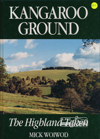
Book, Tarcoola, Kangaroo Ground: The Highland Taken by Mick Woiwod, 1994
"A piece of Scotland in the Australian bush is how author Mick Woiwod describes the "Village" of Kangaroo Ground. Settled in 1841 by a Scottish family, the Donaldsons, the town is the feature of Mrs Woiwod's latest book, "Kangaroo Ground - The Highland Taken" The book follows the history of Kangaroo Ground, from its beginnings as an exclusively Scottish farming community in the middle of nowhere to a town that became the centre of the Yarra Valley region... It took Mr Woiwod six months of intensive research and nine months to write the book on Kangaroo Ground. He spent much of his time searching archives, public records and newspaper files for detailed information on the characters who colour his book." -- Diamond Valley News November 16, 1994 This major history of Kangaroo Ground details the district’s story between 1841 and 1994, describing it as having been unique in the Yarra Valley in that its early settlers were all Scottish and its soils were more fertile than those of surrounding districts. Their soil gave them the sort of power that saw the then extensive Shire of Eltham governed from little Kangaroo Ground for a remarkable 69 years. The author describes the Kangaroo Ground landscape that these farmers worked in the early period as having been already significantly modified by Aboriginal fire-stick farming before their arrival. This publication is a significant title in the recording of the early history of the pioneers of the small area of Kangaroo Ground, VictoriaHardback Book, 312 pagesISBN 0646209000kangaroo ground, mick woiwod, pioneers, donaldson family, thomson family -
 Eltham District Historical Society Inc
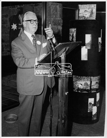
Photograph, Opening of Eltham Library, 17 Aug 1971
The architect of Eltham's new library, Harold Bartlett of Messrs Leith & Bartlett Pty Ltd at the opening of the Eltham Library in 1971. The Eltham Branch of the Heidelberg Regional Library Service was opened on 17 August 1971 by Victoria’s Chief Secretary R. J. Hamer. The library was designed by the firm Leith and Bartlett and was the southern wing of the Shire of Eltham Offices in Main Road Eltham. Visitors entered a “book plaza” which embodies the display techniques of a bookshop. Through this area was located a quieter area for reference and the more “purposeful” reader. The library was opened as part of the Shire of Eltham’s centenary celebrations. Diamond Valley News, 24 August 1971 Wisdom of Solomon. "The architect of Eltham's new library, Mr Harold Bartett, at the opening of the library last week said: " Decisions to build such cultural builidngs as this with so little money and so many other basic items on the priority list are not taken without long hours of thoughtful debate demanding the wisdom of Solomon, the knowledge of a Moses, the business acumen of a money changer, the tender heart of a Rachael, the couriage of a David and last, but not least, the armour of a centurion." Thus, he described the attributes required in a municipal councillor. Mr Bartlett is a former councillor and is still honorary planner for the shire." H. E. Bartlett was on the Shire of Eltham Council 1954-1961. The library and Shire Offices were demolished exactly 25 years later in 1996. This photo forms part of a collection of photographs gathered by the Shire of Eltham for their centenary project book, "Pioneers and Painters: 100 years of the Shire of Eltham" by Alan Marshall (1971). The collection of over 500 images is held in partnership between Eltham District Historical Society and Yarra Plenty Regional Library (Eltham Library) and is now formally known as 'The Shire of Eltham Pioneers Photograph Collection.' It is significant in being the first community sourced collection representing the places and people of the Shire's first one hundred years.Digital imagesepp, shire of eltham pioneers photograph collection, shire of eltham, shire of eltham centenary, eltham library, opening day, h. bartlett, harold bartlett, sppech -
 Eltham District Historical Society Inc
Photograph, Doug Orford, Maryborough Railway Station, Spring Excursion to Maryborough, 27 September 1992, 27/09/1992
[from EDHS Newsletter No. 86, September 1992:] SPRING EXCURSION MARYBOROUGH: As a Spring excursion our bus trip on 27th September is well timed - Maryborough is conducting its Wattle Festival on that weekend. We are to be guests of the Midlands Historical Society who will provide a guide for our tour of the town. This is a somewhat longer trip than we usually undertake so we have an earlier start at 8.00 am and the cost is a little more than usual at $20.00. The entry to the Midlands Society's Worsley Cottage is included. At the end of the town tour we will visit the C.W.A.'s Fair which is part of the Wattle Festival. Afternoon tea will be available there for a small charge. Bring your lunch and something for morning tea if you wish. We will be travelling to Maryborough via Creswick and Clunes and returning via Castlemaine. We will return about 6.00 pm and transport home can be arranged if required. Maryborough has a rich history with the gold era being particularly significant. Local historian Betty Osborne has produced the book "Maryborough - a Social History 1854-1905". You might like to try and obtain it from the library for advance reading or it will be available for purchase on the day at $25.00. To book for this tour please complete the attached from and return with your payment to the September meeting or send it to our post office box. Friends are most welcome as usual.Two colour photographsactivities, maryborough -
 Eltham District Historical Society Inc
Photograph, At Creswick, Spring Excursion to Maryborough, 27 September 1992, 27/09/1992
[from EDHS Newsletter No. 86, September 1992:] SPRING EXCURSION MARYBOROUGH: As a Spring excursion our bus trip on 27th September is well timed - Maryborough is conducting its Wattle Festival on that weekend. We are to be guests of the Midlands Historical Society who will provide a guide for our tour of the town. This is a somewhat longer trip than we usually undertake so we have an earlier start at 8.00 am and the cost is a little more than usual at $20.00. The entry to the Midlands Society's Worsley Cottage is included. At the end of the town tour we will visit the C.W.A.'s Fair which is part of the Wattle Festival. Afternoon tea will be available there for a small charge. Bring your lunch and something for morning tea if you wish. We will be travelling to Maryborough via Creswick and Clunes and returning via Castlemaine. We will return about 6.00 pm and transport home can be arranged if required. Maryborough has a rich history with the gold era being particularly significant. Local historian Betty Osborne has produced the book "Maryborough - a Social History 1854-1905". You might like to try and obtain it from the library for advance reading or it will be available for purchase on the day at $25.00. To book for this tour please complete the attached from and return with your payment to the September meeting or send it to our post office box. Friends are most welcome as usual.Colour photographactivities, maryborough -
 Eltham District Historical Society Inc
Photograph, Doug Orford, Aboriginal waterholes at Maryborough, Spring Excursion to Maryborough, 27 September 1992, 27/09/1992
[from EDHS Newsletter No. 86, September 1992:] SPRING EXCURSION MARYBOROUGH: As a Spring excursion our bus trip on 27th September is well timed - Maryborough is conducting its Wattle Festival on that weekend. We are to be guests of the Midlands Historical Society who will provide a guide for our tour of the town. This is a somewhat longer trip than we usually undertake so we have an earlier start at 8.00 am and the cost is a little more than usual at $20.00. The entry to the Midlands Society's Worsley Cottage is included. At the end of the town tour we will visit the C.W.A.'s Fair which is part of the Wattle Festival. Afternoon tea will be available there for a small charge. Bring your lunch and something for morning tea if you wish. We will be travelling to Maryborough via Creswick and Clunes and returning via Castlemaine. We will return about 6.00 pm and transport home can be arranged if required. Maryborough has a rich history with the gold era being particularly significant. Local historian Betty Osborne has produced the book "Maryborough - a Social History 1854-1905". You might like to try and obtain it from the library for advance reading or it will be available for purchase on the day at $25.00. To book for this tour please complete the attached from and return with your payment to the September meeting or send it to our post office box. Friends are most welcome as usual.Colour photographactivities, maryborough -
 Eltham District Historical Society Inc
Photograph, Doug Orford, From Maryborough Lookout, Spring Excursion to Maryborough, 27 September 1992, 27/09/1992
[from EDHS Newsletter No. 86, September 1992:] SPRING EXCURSION MARYBOROUGH: As a Spring excursion our bus trip on 27th September is well timed - Maryborough is conducting its Wattle Festival on that weekend. We are to be guests of the Midlands Historical Society who will provide a guide for our tour of the town. This is a somewhat longer trip than we usually undertake so we have an earlier start at 8.00 am and the cost is a little more than usual at $20.00. The entry to the Midlands Society's Worsley Cottage is included. At the end of the town tour we will visit the C.W.A.'s Fair which is part of the Wattle Festival. Afternoon tea will be available there for a small charge. Bring your lunch and something for morning tea if you wish. We will be travelling to Maryborough via Creswick and Clunes and returning via Castlemaine. We will return about 6.00 pm and transport home can be arranged if required. Maryborough has a rich history with the gold era being particularly significant. Local historian Betty Osborne has produced the book "Maryborough - a Social History 1854-1905". You might like to try and obtain it from the library for advance reading or it will be available for purchase on the day at $25.00. To book for this tour please complete the attached from and return with your payment to the September meeting or send it to our post office box. Friends are most welcome as usual.Two colour photographsactivities, maryborough -
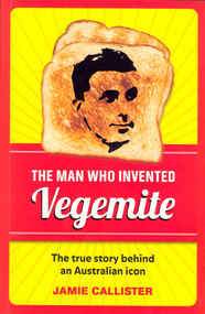 Federation University Historical Collection
Book, Jamie Callister, The Man Who Invented Vegemite, 2012
Cyril Percy Callister, a chemist by training, became a food technologist and the inventor of the well known spread 'Vegemite'. A Ballarat School of Mines (SMB) student around 1910, Callister then went to Melbourne University where he obtained his B.Sc. in 1914, M.Sc. in 1917 and D.Sc. in 1931. With Sir David Rivett in 1931 he secured the royal charter for the Royal Australian Chemical Institute, becoming president of the Society of Chemical Industry of Victoria in 1935-36. Vegemite, a yeast based spread, and perhaps one of most famous trademarks in Australia, was discovered around 1922 by Cyril Percy Callister. He was hired by the Fred Walker Company (a Melbourne based manufacturer later known as Kraft) as a laboratory assistant to develop a yeast extract spread. It took some years but by 1954 the special Vegemite song 'Happy Little Vegemites' demonstrated the popularity of the spread. Callister was also known for packing cheese in a can to preserve it and developing Kraft processed cheese. he son of a school teacher and postmaster he was born at Chute on 16 February 1893 and died on 5 October 1949. His brother Reginald Clive Callister (1889-1971) was also a student of SMB. (http://www.ballarat.edu.au/about-ub/history/art-and-historical-collection/ub-honour-roll/c/cyril-callister-1893-1949)Red and yellow soft covered book of 208 pages relating to Cyril Callister who invented Vegemite. On Frontispage signed "11th Oct 2012 James Callister"ballarat school of mines, callister, cyril callister, vegemite, william callister -
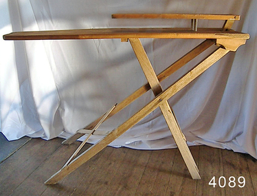 Flagstaff Hill Maritime Museum and Village
Furniture - Ironing board, 1910-1930
Ironing is the use of a machine, usually a heated tool (an iron), to remove wrinkles from fabric. The heating is around 180–220 °Celsius, depending on the fabric type. Ironing works by loosening the bonds between the long-chain polymer molecules in the fibres of the material. While the molecules are hot, the fibres are straightened by the weight of the iron, and they hold their new shape as they cool. Some fabrics, such as cotton, require the addition of water to loosen the intermolecular bonds. Many modern fabrics developed in or after the mid-twentieth century require little or no ironing. Permanent press clothing was developed to reduce the ironing necessary by combining Wrinkle resistant polymers with cotton. The first known use of the iron for removing wrinkles in clothes is known to have occurred in China, and the electric iron was invented in 1882, by Henry W. Seeley. Seeley patented his "electric flat iron" on June 6, 1882 (U.S. Patent no. 259,054). On 15 February 1858 W. Vandenburg and J. Harvey patented an ironing table that facilitated pressing sleeves and pants legs. A truly portable folding ironing board was first patented in Canada in 1875 by John B. Porter. The invention also included a removable press board used for sleeves. In 1892 Sarah Boone obtained a patent in the United States for improvements to the ironing board, allowing for better quality ironing of shirt sleeves.A domestic item with an interesting history of development, significant as it shows the progress and the evolution of a domestic item designed to make housework more efficient.Wooden Ironing board with press board for sleeves, board is folding.Noneflagstaff hill, warrnambool, shipwrecked-coast, flagstaff-hill-maritime-museum, flagstaff-hill-maritime-village, domestic item, ironing board, ironing, clothes, wrinkles in clothes, henry w. seeley, w. vandenburg and j. harvey -
 City of Moorabbin Historical Society (Operating the Box Cottage Museum)
Clothing - Clothing, City of Moorabbin Tie, Circa 1960s
The City of Moorabbin existed from 1934 until 1994. Henry Dendy's Special Survey in 1841 of 5,120 acres in the Parish of Moorabbin , extended from Port Phillip Bay , then East to Boundary Road, South to South Road and North to North Road and became known as Brighton. 1859 Brighton became a Borough with its boundary Thomas Street ,and Bluff Road. In 1862 The Moorabbin Roads Board was formed and the extended area now included Cheltenham, Hampton, Sandringham, Black Rock, Beaumaris, Mentone and Mordialloc .and Little Brighton became known as Bentleigh. In 1871 the area became known as The Shire of Moorabbin. Gradually the area was separated into The Borough of Sandringham 1917, ( Black Rock, Beaumaris , Sandringham and Hampton ) Borough of Mentone and Mordialloc 1920, ( Parkdale ). In 1934 The City of Moorabbin was established for the area from South East corner of Thomas Street and North Road , East to Warrigal Road, Clayton Road, Kingston Road , Lower Dandenong Road, then South along Nepean Highway to Balcombe Road and along Bluff Road, Cummins Road, Nepean Highway, Thomas Street to North Road In the 1994 Amalgamation of Councils the City of Moorabbin was divided between the new City of Kingston in the South ( from South Road) and the new City of Glen Eira to the North . It was the largest Municipality in Victoria with a population of 118,865 in 1974This tie c 1960 is a memento of the City of Moorabbin 1934 - 1994Maroon colour, polyester, man's tie with the crest of City of Moorabbin woven on front.around circle enclosing Coat of Arms ; CITY OF MOORABBIN city of moorabbin, moorabbin roads board, moorabbin, brighton, dendy's special survey 1841, early settlers, pioneers, market gardners, dendy henry, were jonathan b, cheltenham, bentleigh, mentone, sandringham, mair william, bent thomas -
 Flagstaff Hill Maritime Museum and Village
Functional object - Wood sample, circa 1840
This oak wood sample is part of the wooden barque, the Grange, built in 1840. The wood sample was recovered from the shipwreck of the Grange in around 1968, 110 years after the Grange was wrecked (see below for further details on the Grange). It is part of the John Chance Collection. THE GRANGE, 1840-1858- The wooden barque ’Grange’ was a three-masted ship built in Scotland in 1840 for international and coastal trade. On March 22, 1858, the Grange set sail from Melbourne under Captain A. Alexander, carrying a cargo of ballast. The barque had left the Heads of Phillip Bay and was heading west along the Victorian coast towards Cape Otway. The ship struck Little Haley’s Reef at Apollo Bay due to a navigational error and was stuck on the rocks. The crew left the ship carrying whatever they could onto the beach. Eventually, the remains of the hull, sails and fittings were salvaged before the wreck of the Grange broke up about a month later. About 110 years later, in 1968, the wreck of the Grange was found by divers from the Underwater Explorers Club of Victoria. They were amazed to find a unique, six to nine pound carronade (type of small cannon) and a cannonball on the site. There have been no other similar carronades recorded. In that same year the anchor of the Grange was recovered by diver John Chance and Mal Brown. The wood sample is significant historically as an example of hardware used when building wooden ships in the early to mid-19th century. The sample is historically significant as an example of the work and trade of blacksmith. The sample is also has significant as it was recovered by John Chance, a diver from the wreck of the Grange in the 1968. Items that come from several wrecks along Victoria's coast have since been donated to the Flagstaff Hill Maritime Village’s museum collection by his family, illustrating this item’s level of historical value. The sample is historically significant for its association with the 1840s wooden barque, the Grange. The Grange is an historical example of a Scottish built vessel used for international and coastal trader of both cargo and passengers in the mid-19th century. The Grange is an example of an early ship, designed with a wooden hull. It is significant as a ship still available to divers along the south coast of Victoria, for research and education purposes. The Grange is an example of a mid-19th century vessel that carried a weapon of defence onboard. Wood sample, oak wood fixed between plates and secured by a washer and bolt. There are five layers, each decreasing in size from base to the top. The bottom is a five-sided copper plate, above it is the oak sample that is crumbling and fragile, then a half-disc metal plate, then a square metal washer, then a round metal bolt head. The metal plate has unequal sides, the longest is parallel to the strait side of the half disc. flagstaff hill, warrnambool, flagstaff hill maritime museum, maritime museum, shipwreck coast, flagstaff hill maritime village, great ocean road, west coast trader, apollo bay, mid-19th century shipwreck, the grange, scottish barque, little henty reef, captain a alexander, underwater explorers club of victoria, 1840s carronade, vhr 5297, coastal trader, wooden shipwreck, john chance, wood sample, wooden ship, oak timber, ship fitting -
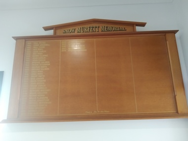 Peterborough History Group
Memorabilia - Snow Murfett Memorial Honour Board
Honour Board in memory of Ross "Snow" Murfett, who died in 1983, aged 33 and who's family and friends holidayed in Peterborough. His mates played an informal competition, in Timboon the first year, but thereafter at Peterborough. The tournament grew in popularity among his mates until the Golf Club incorporated it into their program and it became an annual event open to all.It is still popular with Snow's friends. SNOW MURFETT MEMORIAL 1984 Paul Irving 2002 John Brown 1985 Eddie Arundell 2003 Frank Carlin 1986 Paul Togni 2004 Chris Farrelly 1987 Ned Ryan 2005 Bernard Moloney 1988 John Carlin 2006 Bruce Hallows 1989 Ned Ryan 2007 Bernie Kenna 1990 Kerry Clarke 2008 Bruce Flanders 1991 John Carlin 2009 Wayne Johnstone 1992 John Carlin 2010 Michael Heffernan 1993 Brooke Salmon 2011 Noah Mounsey 1994 Frank O’Connor 2012 Darren Little 1995 George Smith 2013 Eric Burchell 1996 Brooke Salmon 2014 James McKenzie 1997 Greg Ryan 2015 Sarah Case 1998 Greg Ryan 2016 James McKenzie 1999 Geoff Smith 2017 Brendan Hickey 2000 Bob Loader 2018 Stephen Vaughabn 2001 David Rogers Significant as it is in memory of a family who have been visiting Peterborough since the 1940's. Also, many current homeowners and visitors were friends with Snow.3 ft x 6ft, timber honour board with gold printingInscribed in gold "donated by Glen and Alison Christian" with gold printing listing the event winners from 1984ross murfett, peterborough golf club, peterborough -
Tatura Irrigation & Wartime Camps Museum
Instrument - Cornet, Brass Cornet
After WW1 the Wilhelma Templer village bought ex WW1 German Armed Forces Brass instruments for their own Brass Band. The Treaty of Versailles forbade Germany from having more than a 10,000 man army thus creating a flood of unwanted instruments with no one having cash to buy them. With the deportation in August 1941 by the British Mandate of most Templers from Palestine to Australia, one of the young bachelors, Gustav Reichert, obtained permission to bring these instruments to Tatura. This he did and, in Camp 3, a band was reformed to entertain members of both internees and often, Camp Authorities. Gustav enjoyed playing the double brass with the Melbourne Templer Brass Band in the 1960-1970's. The above instruments have semi-rotary valves, as traditionally French Horns do, unlike most Anglosaxon bands, where piston valves are used almost exclusively. Yet in German the name Piston is commonly used for cornet. Though battered, these instruments are all still serviceable for their intended use, some more so than others. Their canvas carry bags offered little protection. The group comprised 1 double bass, 1 Euphonium, 1 valve bass trombone, all in C, 3 baritones in Bb (German tenor horns), 3 cornets in Bb, 1 soprano cornet in Eb, in all 11 instruments. Some of the got "lost".Brass cornet with a canvas carry bag.brass instruments, wilhelma templer village, camp 3 band, gustav reichert -
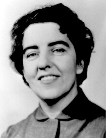 Surrey Hills Historical Society Collection
Photograph, Matron Joan Bray of Barton Street, Surrey Hills
Joan Mary Bray was born 6/9/1915 in Brisbane, the daughter of Herbert Edward Bray and his wife Grace (nee Shepherd) who married in Wisbech, Cambridge in 1892. The family lived at 5 Barton Street from the late 1920s. She completed her primary schooling at Auburn Primary by travelling there by the little black bus along Canterbury Road. She then went on to Mont Albert Central School and Melbourne Girls High. Locally she belonged to the 1st Surrey Hills Girl Guide Company at Holy Trinity Church. She trained as a nurse at Epworth Hospital and in 1941 served with the army at Gaza Hospital in the Middle East, then in New Guinea. From 1944 until the end of the war she was in Bougainville. Her mother died in Surrey Hills 29/9/1945 and her father moved to Hawthorn; he died in 1955. She had 3 older sisters: Eveline Grace (1893-1978) m Eric Benson; Violet Constance (1894-1983 - ? Sister Constance in mother’s death notice); Dorothy Maud (1896 - ? Sister Ursula in mother’s death notice). After the war she was a RSSL nurse, Matron of St Gabriel’s Baby Home in Balwyn, then Director of Nursing at the Royal Eye and Ear Hospital, East Melbourne. She resigned to be married. [No success in locating her marriage, presumed to be to UNKNOWN Wicks.]Black and white head and shoulders portrait of Joan Bray. She is wearing a plain shirt or jacket.barton street, mont albert central school, auburn primary school, melbourne girls high school, girl guides, 1st surrey hills girl guide company, nurses, nursing, hospitals, health services, australian army nursing service, world wars, 1939-1945, epworth hospital, st gabriel's baby home, eye and ear hospital, (miss) joan mary bray, matron joan bray, (mrs) joan wicks -
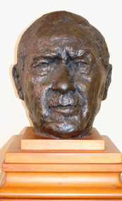 Federation University Art Collection
Sculpture - Bust, Greenhalgh, Victor, Dick Richards by Victor Greenhalgh
Victor GREENHALGH (1900-1983) Born Australia Victor Greenhalgh studied at at the Ballarat School of Mines, and was appointed to the staff in 1938. He was the commissioned sculptor for the King George V statue located in Ballarat's Sturt Street Gardens, as well as eight of the portrait busts of Australian Prime Ministers which line the "Avenue of Prime Ministers" in the Ballarat Botanical Gardens. From 1938 he taught at the Royal Melbourne Institute of Technology (RMIT). The bust of Dick Richards was Victor Greenhalgh's last work, and was cast after the sculptors death. It was donated to the Ballarat School of Mines by Victor Greenhalgh's wife Violet Greenhalgh (Hambly). Dick Richards and Victor Greenhalgh were brothers-in-law. Dick Richards was a member of Shackleton's ill-fated Trans-Antarctic Expedition, and was awarded the Albert Medal for his heroic contribution as a member of the Ross Sea Shore party. In 1972 the Albert Medal was exchanged for the more widely recognised George Cross. Speaking at the unveiling of the sculpture in Dick Richards said that on his return fro the expedition in 1917 he had little inclination for a sedentary or a teaching career. By the time he retired in 1958 he was not at all sorry that he had spent his life as a teacher. Victor Greenhalgh died in Queensland in 1983. This item is part of the Federation University Art Collection. The Art Collection features over 2000 works and was listed as a 'Ballarat Treasure' in 2007.Bronze bust of Antarctic Explorer and former Principal of the Ballarat School of Mines, Richard W. Richards.art, artwork, dick richards, r.w. richards, richard w. richards, victor greenhalgh, antarctic explorer, alumni, violet greenhalgh, violet hambly, sculpture, staffmember, ballarat technical art school, school of mines ballarat -
 Melton City Libraries
Newspaper, Melton Fire Station, 1974, 1975
In 1975 the Melton Fire Station opened in McKenzie Street. In the 1950s with the introduction two-way HF and later VHF very high frequency radio sets. Melton Rural Fire Brigade was part of the Bacchus Marsh Group. Radio sets where located in the Melton Fire Truck, and in the house of the Barrie family at Ferris Road. This was an ideal location to observe a 360 degree view in all directions when smoke appeared on the horizon. An antenna was erected beside the house. The set OX 7 was located in the kitchen and monitored 24 hours by the family. When an electrical fire occurred at the junction of the electricity to the house there was time to radio the fire station and summons the men working in the paddocks, thus saving the house from possible destruction. With the introduction of UHF – ultra high frequency Vinten Radios the signal was clearer and static and interference lessened and radio traffic became easier to read, and reduced noise levels in the household. In 1974 when the family moved to First Avenue, another antenna and a small building were erected adjacent to the residence and used to house the equipment, maps. Radio traffic consisted of regular schedule times and communication with adjoining groups of brigades such as Bacchus Marsh, Mt Macedon and Little River Groups. Many of the brigade and group base radios were situated in private residences and operated primarily by fire fighters wives who held the position of Communications Officer, either registered as a brigade member or informally.Regional News Gazette article about the construction of a new fire station in Melton and an Express article with brigade members at the opening of the station.emergency services -
 Melbourne Legacy
Article, Bulletin VALE Legatee Cyril Terence Charles Kirby
An article from the Melbourne Legacy Bulletin on the death of Legatee Cyril Terence Charles Kirby, a long serving Legatee. The Bulletin published articles on Legatees when they passed away. The article includes an overview of his war service with the British as an 'Old Contemptible' in World War 1. Also with the Docks and Movement Control in Melbourne during World War 2. He met his wife Priscilla Wardle during World War 1 and moved to Ballarat to marry her. Priscilla was an Australian nurse serving with the QAIMNS and part of her diary is in this collection, and more is held with Ballarat and District Bast Hospital Nurses League also on Victorian Collections. He joined Legacy in Ballarat in 1929 and transferred to Melbourne Legacy in 1935. Even when his health caused him to reduce his commitments to the Reserve list he still found time to attend Legacy and spent many hours each month doing clerical work and fund raising. "Keeping everyone amused with his inexhaustible supply of 'little stories', and in a word, doing a thoroughly good Legacy job." The account of his life was written by Legatee Brian Armstrong (initials JHBA) and has a very affectionate tone. The article was found in the bound copies of the Weekly Bulletin and copied due to the link with Priscilla Wardle when the diary was returned to the family in May 2021.A record of the life and service of Legatee Terry Kirby The information was collected to record the lives of prominent legatees in a folder.Photocopy of a page from the Legacy Weekly Bulletin on the death of Legatee Terry Kirby.Bulletin No. 1961 14 May 1968 page 1.vale, terry kirby -
 Melbourne Tram Museum
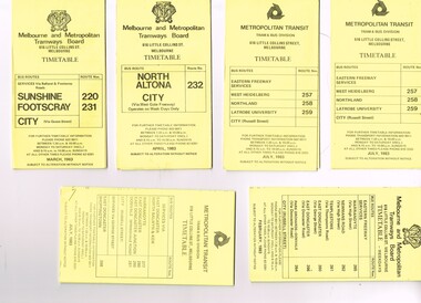
Ephemera - Timetable/s, Melbourne & Metropolitan Tramways Board (MMTB), "MMTB Bus Timetables", 1983
Timetables for specific routes, day of week giving information on tram times at specific time points, route map, sections and fares and organisation address - 616 Little Collins St. Melbourne. All printed on yellow paper unless noted otherwise. .1 - Route 220 and 231 - Sunshine - Footscray - City - March 1983 .2 - North Altona - City via West Gate Freeway - April 1983 .3 - Route 257, 258, 259 - West Heidelberg, Northland, Latrobe University - City - July 1983 .4 - ditto .5 - Route 265, 262, 261, 260, 266, 264 - Warrandyte, Templestowe, Doncaster, Park Orchard - Donvale - City - Feb. 1983 .6 - Route 277, 280, 299, 281 and 268 - Warrandyte, East Doncaster, Donvale, Shoppingtown - July 1983 .7 - Route 287, 286, 302, 303 Box Hill, Mitcham, East Doncaster, Mitcham, Ringwood - June 1980 .8 - ditto - but November 1983 .9 - Route 313, 314, 315, 316 - Warrandyte, Park Orchards, Mitcham - Jan. 1983 .10 - as for .8 11 - Routes 265, 262, 261,260, 266 and 264 - Warrandyte - Eastern Freeway, Templestowe, Park Orcards - Feb. 1983 12 - Routes 277, 280, 281 and 268 - East Doncaster, Donvale, City and Shoppingtown - Jan. 1983 Items .3, .4, .6, .8 and .10 are headed "Metropolitan Transit", rest MMTB.Yields information about MMTB Bus Services 1983Set of 12 MMTB or Metropolitan Transit Bus timetables, folded sheets, generally 10 sections.trams, tramways, mmtb, timetables, melbourne, fares, buses, deer park, sunshine, footscray, latrobe university, northland, heidelberg, box hill, warrandyte, doncaster, donvale, mitcham, ringwood, park orchards -
Melbourne Tram Museum
Document - Digital Image, Victorian Transport Action Group (VTAG), "Melbourne’s Tram Plan Response Filling the Gaps", March 2024
Document produced by the Victorian Transport Action Group as a response to the Department of Transport "Melbourne Tram Plan" of Oct. 2023 - see item 7364. VTAG have produced a number of initiatives and looks at a number of route proposals that have been made by Government but as of the end of 2024, little progress has been made on any of them. Initiatives suggested are: 1. Confirm its commitment to previously announced projects (listed in Table 1) and provide indicative timeframes for completion. 2. Redirect routes 3, 5 and 12 (detailed in Table 2) with the opening of MM1 to improve the distribution of tram services through the central area. 3. Direct Infrastructure Victoria to undertake the specific planning process as part of the next state infrastructure plan to canvas a range of possible network enhancements. 4. Revise the selection of stops for upgrade to level access to include the practical considerations of technical feasibility and constructability to ensure that as many stops as possible are delivered as a priority. 5. Expand the corridor-based approach being applied to upgrade stops to include the implementation of traffic priority along the selected corridors. 6. Adopt a 15mins, or at least 20 mins, as the maximum headway for all Melbourne tram routes. Notes changes that will be needed as a result of the Melbourne Metro in 2025, tram stops, energy efficiency, renewing the fleet and infrastructure, network performance, and passenger experience. Demonstrates a response to the Vic Govt's tram plan by an Action Group.Digital copy of a 21 A4 page document produced by the Victorian Transport Action Group March 2024. tramways, victorian government, department of transport, planning, vtag -
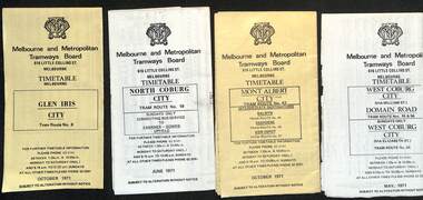 Melbourne Tram Museum
Ephemera - Timetable, Melbourne & Metropolitan Tramways Board (MMTB), MMTB Tram timetables, set of 12, 1971
Timetables for specific routes, day of week giving information on tram times at specific time points, route map, sections and fares and organisation address - 616 Little Collins St. Melbourne. 1 - Glen Iris - City route 6 - Oct. 1971 2 - North Coburg with connecting bus to Fawkner and Gowrie - Upfield on Sundays - June 1971 3 - Mont Albert - City - routes 42, 44, 45, 37 - Oct. 1971 4 - West Coburg - Domain Road and West Coburg City on Sundays - routes 55, 56 and 68 - May 1971 5 - Essendon Aerodrome - City route 59 - June 1971 6 - East Brighton - City - routes 64, 65, 62, 61 - Oct. 1971 7 - Carnegie - City - routes 67, route 66 - Oct. 1971 8 - Wattle Park - City route 70, route 71 and route 76 - Oct. 1971 9 - Camberwell - City - route 72, route 73 - Oct. 1971 10 - Prahran - City, North Richmond -Prahran - St Kilda Beach, routes 77, 78 and 79 - Oct. 1971 11 - East Preston - City and East Brunswick - City - routes 88, 89, 90. 96 and 97 - Oct. 1971 12 - ditto for Sundays printed on green paper. 13 - Route 8, Toorak, Oct. 1971-*Yields information about 1971 MMTB timetables.Set of 12 1971 MMTB Tram timetables, folded sheets.trams, tramways, timetables, mont albert, route 42, route 6, route 19, upfield, route 44, route 45, route 37, route 55, route 56, route 68, route 59, route 64, route 65, route 62, route 61, route 67, route 66, route 70, route 71, route 76, route 72, route 73, route 77, route 78, route 79, route 88, route 90, route 96, route 97, route 8 -
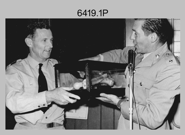 Bendigo Military Museum
Photograph - Bones Day - Army Survey Regiment Versus RAAF School of Radio, 1969
These two photographs were taken at Bones Day, an annual sports competition between the Army Survey Regiment and the RAAF School of Radio in 1969. The two units took turns each year to host the event and on this occasion was held at the RAAF School of Radio, Laverton. The day competition usually comprised basketball, cross country, golf, sailing, squash, softball, tennis, touch football, rifle shooting, tug-of-war and volleyball. The “big bone” trophy comprising a large bone from a beast housed inside a wooden framed glass case, was awarded to the winner of the day competition. The evening competition often included darts, carpet bowls, hookey, quoits and billiards/snooker. The “little bone” (a mounted chicken bone) was the consolation trophy awarded to the winner of the evening competition. The 3-hour bus trip for the visiting unit on their return was typically very raucous. The history of the Bones Day competition is best described in the booklet titled - Bones of Contention Souvenir Program. 1965. Refer to Item 6267. The winner of the two trophies in 1969 is not known. MAJ Donald Ridge was probably on this occasion was the 2IC of the Army Headquarters Survey Regiment, He was subsequently promoted to the rank of LTCOL was the CO of the unit from 1972 to 1973; and continued as the CO of the renamed Army Survey Regiment from 1974 to 1975. He served from 1946 to 1975.These two photographs were taken at Bones Day, an annual sports competition between the Army Survey Regiment the RAAF School of Radio in 1969. The photographs were printed on photographic paper and are part of the Army Survey Regiment’s Collection. They were scanned at 300 dpi. .1) - Photo, black & white, 1969. L to R: Unidentified CO or representative from the RAAF School of Radio, MAJ Don Ridge. .2) - Photo, black & white, 1969. L to R: MAJ Don Ridge, unidentified CO or representative from the RAAF School of Radio..1P to .9P – no annotationsroyal australian survey corps, rasvy, army survey regiment, army svy regt, fortuna, asr, bones day, raaf school of radio -
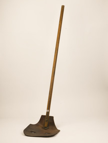 Forests Commission Retired Personnel Association (FCRPA)
Fire Beater - Leather, c 1940s
Bushfire perimeter rather than bushfire area is the main control problem for firefighters on the ground. A conundrum rapidly compounded by spot fires. A small 5 ha fire can be nearly 1 km around the perimeter. That's a long way to build a control line by hand in rough bush. Dry firefighting techniques by hand were mostly confined to “knocking down” or “beating out” the flames, as well as "digging out". Digging or raking a “mineral earth” trail down to bare dirt proved most effective in forest fuels which, unlike grass, tend to retain heat and smoulder. Early tools were whatever happened to be close at hand. They were simple and primitive and included shovels, slashers, axes, hoes, beaters and rakes. A cut branch to beat the flames was often the only thing available. Farming and logging tools, developed over centuries of manual labour, and readily available at local hardware stores came into use, but little thought was given to size, weight, and balance. This leather beater was based on a century-old stockman's design which used green cow hide leather lashed to a broom handle. It's recommend that users lift no more than above knee height to conserve energy and let the beater to the work. For years foresters experimented with combination tools. In about 1952 fire beaters and other implements were being replaced with Rakuts and later RakehoesEarly firefighting toolBushfire beater - Leather with wooden handlebushfire, forests commission victoria (fcv) -
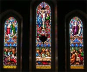 Christ Church Anglican Parish of Warrnambool
Memorial Windows: Jane STEVENS
Frederick Perkin Stevens was a prominent in business and community matters. He also presented the peal of three German bells in 1881 as a memorial to his and Jane’s son.. These windows are among the earliest stained glass windows in Christ Church and because of their position make a strong visual impact in the church. Further, Frederick later married Emma Bews, sister-in-law of the Reverend Peter Tuelen Beamish, first Vicar of the Parish of Warrnambool (for a period of 45 years 1850-1895,), thus consolidating his association with the church. Three lancet stained-glass windows, east wall, main nave, above the High Altar. Presented by Frederick Perkins STEVENS in memory of his wife Jane (nee RULE), born abt 1821, died 1868. The windows from left to right depict the Baptism, Crucifixion and Ascension of Jesus. Transversing the lower section is a depiction of the Last Supper. Running across the bottom of the windows is the inscription. Left window: IN MEMORIAM JANÆ VXORIS CARISSIMA REDEMPTORI SVO IN GREMIVM COMMISIT SE ILLAM INTER BEATOS CITIVS Centre: OVAM DISIDERIO SVMMO ANNOS XLVIII NATUM FREDERICUS STEVENS CONJVX VIDVVS QVI REVISVRVM SPAM LÆTAM AMPLECTITVR Right: SEPTIMO ANTE KAL SEXT A.D. MDCCCLXVIII PAVLISPER INTER VIVOS MORATVS HANC FANESTRAM POSVIT This may be translated as: "This window was erected in memory of Jane, his beloved wife, whom at the age of 40 years on the 26th day of July, 1868, with deepest grief and love he committed to the bosom of her Redeemer, by her bereaved husband, Francis Stevens, who tarrying a little while among the living, embraces the hope of meeting her speedily, if it may be, among the blessed." -
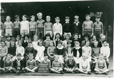 Ringwood and District Historical Society
Photograph, Ringwood State School - Class photograph - Grade 1B, 1955
Black and white photograph - Grade 1B, 1955"Attached to photograph" Back Row- L to R: ?, Barry Carrington, ?, Paul Davies, Phillip Male, David Simpson, Andrew Carter, Barry Falconer, Rodney Roach, Russell Goodall, Robert Clough, Evan Patullock. 2nd Row - L to R: Susan Schurmann, Carmen Powell, Lynette Bangay, Julie Little, Barbara Austin, Marilyn John, Ruth Tozer, ?, Faye McKenzie, ?, Susan Appleby, Leslie Cunningham. 3rd Row - L to R: Grant Austin, Christine Brown, ?, Janet McLeod, Lynette Rodda, Carol O'Reagan, ?, Kathleen Jackson, Christine (?), Anne Hill, Jennifer Whitford, Dragon Milotic. Front Row - L to R: Kenny Boyes, Alan Clarkson, George, Rechnitzer, Ross Warne, Russell Sinclair, Tim Lacone, Bruce Burton, John Semple. Teacher: -
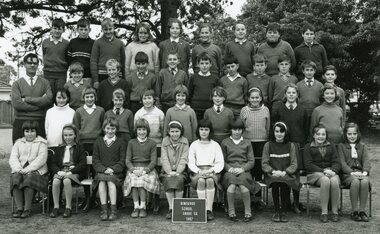 Ringwood and District Historical Society
Photograph, Ringwood State School - Grade 5A, 1967
Black and white photograph "Attached to photograph" Back Row - L to R: Richard Fly, Graeme Reynolds, Colin Grieves, Pam Cleary, ?, Susan Broadly, Dean Barnes, Mikaly Kovendiachou, Peter Hayes. 2nd Row - L to R: Teacher Fred Rogers, ?, Tino Pekkarinen, Glen Pope, David Green, James Taylor, Eric Culmer, Bruce Fuller, Michael Brown, Michael Grayling, David ?. 3rd Row - L to R: Jennifer Walters, Elizabeth Harding, Elizabeth Doig, Susan Little, Sandra Mitchell, Janice Louttit, Jenny Smith, Annette Lighthouse, Linda Cook. Front Row: Bevalla Conner, ?, Julie Reid, Sandra Cook, Lynette Lightfoot, Wendy Thomas, Joy Hall, Roslyn Darian, Josie Trotter, Jenny Critchley. -
 Federation University Historical Collection
Correspondence, John Gray, Letter of Condolence from ANA to John Mateer. 1883, 14/12/1883
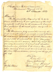
The Australian Natives Association (ANA) Benefit Society was formed in 1871 at a meeting of young men in Grimwood's Hotel, Elizabeth Street, Melbourne. The Association was one of many friendly societies that also aimed to promote the moral, social and intellectual advancement of its members. The young founders restricted membership to native-born Australians, but there were no Koories among them. The Australian Natives Association Ballarat Branch (No4) was founded in 1874. The association’s modest building was based in Camp Street and the branch was one of the most active in the colony, playing a key role in Federation. The Ballarat branch of the ANA was wound up in 1957 and the double storey building has since been used as for office space most recently for employment companies such as Tracey Recruitment. Ballarat's ANA Hall has heritage status under the City of Ballarat’s Camp Street heritage overlay HO186, however it is not listed by either the Victorian Heritage Register or the National Trust.Handwritten letter glued onto a lined page. The letter is from the Australian Natives Association Ballarat Branch No. 4, and is written to John Mateer at the time of his wife's death. The letter is signed by John Gray (President) and Fred Wainwright (secretary). Fred Wainwright was the first secretary of ANA branch No. 4. hew as a clerk at Ballarat Town Hall, and presented an essay on Federation of Australian Colonies in 1879.Australian Natives Association Ballaarat Branch No 4 14th December 1883. Dear Sir The members of this branch of the A.N.A. desire us to convey to you expression of their deep sympanth with you in the irreparable loss you have sustained by the death of your dearly beloved wife. The Members are fully aware that during the first month of such an overpowering infliction the most sincere sympathy of the truest friends can do little by alleviate the bitter pangs of remembrance and sorrow, still they trust that you may be enabled to submit with christian calmness and fortitude to the Will of Him, who, when seeming to act most severely wit us, is in His Own Divine Wisdom, ordering things for the best. We are Dear Sir Yours fraternally John Gray President fred Wainwright Secretary To Mr John Mateer australian natives' association, ana, ballarat branch no. 4. ballaarat branch no. 4, gray, john gray, wainwright, fred wainwright, mateer, john mateer -
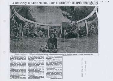 Mission to Seafarers Victoria
Article - Clipping, photocopy, Deborah Stone, The sky’s the limit for modern Michelangelo, 10 May 1988
Louise Hearman used the Norla Dome and painted a mural painted which had taken her around a year to complete. The exhibition called Elephant Room was shown from June 1988. The work was vandalised in 1989 and subsequently demolished.Louise Hearman is a Melbourne born artist and Archibald Prize winner. Hearman first came to public notice in 1987/88 when she spent a year painting the mural in the Norla Dome. The premises of the Mission also served as her studio at that timeBlack and white copy of a newspaper article, printed on A4 paper.The sky’s the limit for modern Michelangelo Because it was there . . . Melbourne artist Louise Hearman in the domed gymnasium of the Mission to Seamen - Picture: ROSS DUNCAN THE dilapidated pool halls of Melbourne’s Mission to Seamen are an unlikely setting for a budding Michelangelo. But when Louise Hearman came across the one-time mission gymnasium she could not resist the urge to create a fresco. It did, however, take a little persuading for the Anglican Church, which still owns and operates a mission in the 61-year-old building, to agreee to house a minor Sistine Chapel on their premises. A year of labour later, Hearman has had no complaints about the great swirling sky or huge oil paintings which now adorn the empty 11-sided room. Instead she is constantly visited by old sailors and passers-by who are thrilled to discover the unusual architecture and artwork. “When peoiple come here it’s a real discovery. It’s something they find for themselves,” she said. Her pictures are neither religious nor symbolic, merely outpourings to create an atmosphere. “THere are lots of things I’d like to say but I’m not saying them in my paintings. “There are no messages, they don’t have any political statement. Life was a little more comfortable for Hearman than her renaissance predecessors. After struggling with cumbersome scaffolding to reach her “canvas” she discovered the modern wonders of the scissor lift. She does not look on the work as a huge achievement. However, it may all be for nought. Unless money is spent to restore the building the paintings she has created will crumble and die - Deborah Stone The Australian Tuesday 10 May 1988louise hearman, elephant room, norla dome, exhibitions, 1988, melbourne, flinders street, ross duncan, cultural events -
Coal Creek Community Park & Museum
Bottle, glass, Between 1872 - 1916 ref: bottle makers mark
TROVE : The Australasian Saturday 8 September 1877, page 20, Town News. 'The first examination of candidates for registration under the Pharmacy Act was held at the Royal Society's Hall yesterday..........The following were passed..........Max Pincus,...........' TROVE : Leader Saturday 2 September 1893 p.4, In: THE LEADER SUPPLEMENT MAX PINCUS, A number of interested spectators are always collected round the stand at which the "Welgel Milk Tester Is being worked by Mr. Max Pincus, of St. Kilda. This milk tester is a little instrument designed for testing the quantity of butter fat In any given sample of milk. The whole manipulation takes only a few minutes, and is so very simple that anyone can work it. A table supplied with the instrument shows at a glance, not only the percentage of butter fat, but also the proportion of same per gallon, the quantity of the milk required to produce each pound of butter, &c., so that there is no calculation ' at all required. Mr. Max. Pincus, who Is tho maker of the "Weigel Tester, shows tho remarkable accuracy of tho instrument. By request he tested a sample of the milk about to be separated, and the result as given to the Government dairy expert showed that the quantity of butter from the churning should be 59 lb. The actual quantity of butter as weighed (after adding 2 lb, of salt) was 61 lb., thus showing that the test agreed perfectly with the churning. In his report to the Minister of Agriculture, the dairy expert expresses himself as very pleased with the working of the Weigel test. The tester has recently been improved so as to measure exactly to tho smallest decimal. Mr. Pincus also shows samples of his butter preservative, called "Salva." In: THE LEADER SUPPLEMENT MAX PINCUS. A number of interested spectators are always collected round the stand at which the Weigel Milk Tester is being worked by Mr. Max Pincus, of St Kilda. This milk tester is a little instru ment designed for testing the quantity of butter fat in any given sample of milk. The whole manipulation takes only a few minutes, and is so very simple that anyone can work it A table supplied with the instrument shows at a glance, not only the percentage of butter fat, hut also the proportion of same per gallon, the quautity of the milk required to produce each pound of butter, &c., so that there is no calculation at all required. Mr. Max Pincus, who is the maker of the Weigel Tester, shows the remarkable accuracy of the instru ment. By request he tested a sample of the milk about to be separated, and the result as given to the Government dairy expert showed that the quantity of butter from the churning should be 59 lb. The actual quantity of butter as weighed (after adding 2 lb. of salt) was 61 lb., thus showing that the test agreed perfectly with the churning. In his report to the Minister of Agriculture, the dairy expert expresses himself as very pleased with the working of the Weigel test. The tester has recently been improved so as to measure exactly to tho smallest decimal. Mr. Pincus also shows samples of his butter preservative, called "Salva." TROVE : MAX PINCUS. A number of interested spectators are always collected round the stand at which the Weigel Milk Tester is being worked by Mr. Max Pincus, of St Kilda. This milk tester is a little instru ment designed for testing the quantity of butter fat in any given sample of milk. The whole manipulation takes only a few minutes, and is so very simple that anyone can work it A table supplied with the instrument shows at a glance, not only the percentage of butter fat, hut also the proportion of same per gallon, the quautity of the milk required to produce each pound of butter, &c., so that there is no calculation at all required. Mr. Max Pincus, who is the maker of the Weigel Tester, shows the remarkable accuracy of the instru ment. By request he tested a sample of the milk about to be separated, and the result as given to the Government dairy expert showed that the quantity of butter from the churning should be 59 lb. The actual quantity of butter as weighed (after adding 2 lb. of salt) was 61 lb., thus showing that the test agreed perfectly with the churning. In his report to the Minister of Agriculture, the dairy expert expresses himself as very pleased with the working of the Weigel test. The tester has recently been improved so as to measure exactly to tho smallest decimal. Mr. Pincus also shows samples of his butter ✏Fix this text preservative, called "Salva."Rectangular pale blue tinted clear glass bottle with angled corners and embossed text on one side and base.'MAX PINCUS LATE JOHNSON ST KILDA' on side. 'M' on base.