Showing 19559 items matching " east"
-
 Ringwood and District Historical Society
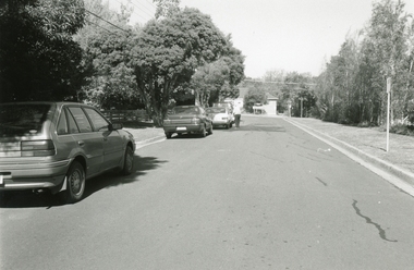
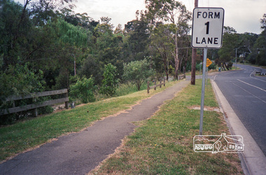
Photographs, Davey Drive, East Ringwood in 1999
-
 Ringwood and District Historical Society
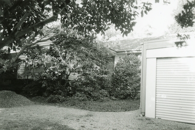
Photographs, House at 4 Davey Drive, East Ringwood circa
Ownws by Marie Ricardo, RDHS member, circa 1997 -
 Eltham District Historical Society Inc
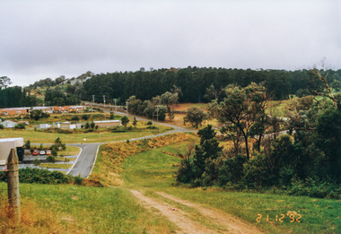
Photograph, Metropolitan Water pipe track east from Afton Street, Research, 19 December 1992, 19/12/1992
The Eltham Horse Trail: Research and Warrandyte to Kinglake: Survey of proposed route, December 1992: (4) Connecting trail to ElthamColour photographeltham horse trail (1992 survey), afton street, research (vic.) -
 Eltham District Historical Society Inc
Photograph, Metropolitan Water pipe track looking east near The Esplanade, Research, 21 December 1992, 21/12/1992
The Eltham Horse Trail: Research and Warrandyte to Kinglake: Survey of proposed route, December 1992: (4) Connecting trail to ElthamColour photographeltham horse trail (1992 survey), research (vic.), the esplanade -
 Eltham District Historical Society Inc
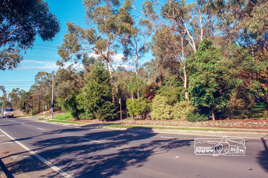
Photograph, Main Road, Eltham looking east towards Bolton Street (south), c.May 2001
Roll of 35mm colour negative film, 7 stripsAgfa HDC 200 plus-2eltham, streets, main road, bolton street -
 Eltham District Historical Society Inc
Photograph, Looking east along Sunray Court to intersection with Gum Hill Court, Eltham, 15 October 1990, 15/10/1990
Colour photographinfrastructure, shire of eltham, streets, eltham, gum hill court, sunray court -
 Eltham District Historical Society Inc
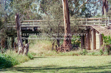
Negative - Photograph, The old Wattletree Road bridge, Eltham on east side of Diamond Creek, 1998c
Viewed from the backyard of the Bakos family residence, 107 Railway Parade Eltham (formerly 137 Railway Parade Eltham) looking north.Roll of 35mm colour negative film, 8 strips and associated 10 x 15 cm colour printKodak Gold 100-5wattletree road, bakos residence, bridge, eltham, railway parade, wattletree road bridge -
 Eltham District Historical Society Inc
Negative - Photograph, Hillview Court, Kangaroo Ground, looking east from end of street, 1998c
Roll of 35mm colour negative film, 8 strips and associated 10 x 15 cm colour printKodak Gold 100-5hillview court, kangaroo ground -
 Eltham District Historical Society Inc
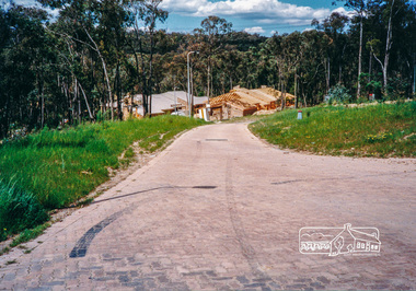
Photograph, Looking east from the northern side of Lower Plenty Road (opposite Bannockburn Road) as it crosses the Watsonia Drain, Viewbank, c.1965, 1965c
Transmission power lines visible in distance behind the Lower Plenty Hotel (in centre upper) and parts of Heidelberg Golf Club. In the foreground a bulldozer can be seen commencing roadworks for the re-alignment of Lower Plenty Road for the new Lower Plenty Bridge crossing.Medium format 120 6x6 black and white negative film, 1 frameheidelberg golf club, lower plenty, lower plenty hotel, road construction, viewbank, watsonia drain -
 Eltham District Historical Society Inc
Photograph, Fred Mitchell, Looking east along Arthur Street just down from intersection with Bible Street, Eltham, 1968, 1968
Valiant is parked outside what was no. 43 now part of a unit complex at no. 41. Immediately in front of Valiant is no. 45, which has been a vacant block since before 1990. Gentleman in hat with paper walking up hill is outside no. 39, now a unit complex and the old house on left is no. 37 (since replaced) which borders what is now the Walter Withers ReserveDigital copy of colour photographfred mitchell collection, 1968, bible street, arthur street, eltham, houses, streets -
 Eltham District Historical Society Inc
Photograph, Fred Mitchell, Looking east from the top of the hill on Bridge Street down towards Bible Street, Eltham, 1968, 1968
Digital copy of colour photographfred mitchell collection, 1968, bible street, eltham, houses, bridge street, road construction -
 Eltham District Historical Society Inc
Photograph, Fred Mitchell, Looking east across Main Road Bridge over the Diamond Creek, Eltham South, 1983, 1983
Digital copy of colour photographfred mitchell collection, 1983, main road bridge, eltham south -
 Eltham District Historical Society Inc
Photograph, Fred Mitchell, Looking east across Main Road Bridge over the Diamond Creek, Eltham South, 1983, 1983
Digital copy of colour photographfred mitchell collection, 1983, main road bridge, eltham south -
 Eltham District Historical Society Inc
Photograph, Main Road just east of Wattletree Road, Eltham, February 1990, 1990
Roll of 35mm colour negative film, 4 stripsFuji 100eltham, main road -
 Eltham District Historical Society Inc
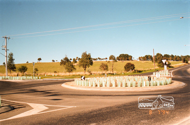
Photograph, Looking south-east at the intersection of Eltham-Yarra Glen Road and Kangaroo Ground-Warrandyte Road, Kangaroo Ground, 8 July 1994, 08/07/1994
Roll of 35mm colour negative film, 4 stripsFuji 100kangaroo ground, eltham-yarra glen road, kangaroo ground-warrandyte road -
 Federation University Historical Collection
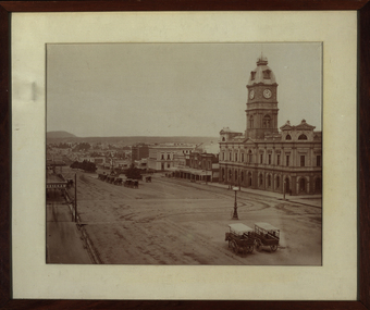
Photograph - Black and White Photograph, Sturt Street Ballarat - Looking East, 1872
Framed black and white photograph of Sturt Street Ballarat showing the Ballarat Town Hall on the right hand side. ballarat, ballarat townscape, ballarat streetscape, ballarat town hall, architecture, tower, carriage, horse, lamp, bluestone, william bardwell, fotobiennale, mount warrenheip -
 Federation University Historical Collection
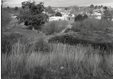
Photograph - Photograph - Black and White, Paul Lambeth, End of Clissold Street, From Black Hill, Ballarat East, 1992
Black and white photograph showing Ballarat from Black Hill. in pencil on verso "Black Hill Ballarat" and "taken alongside the walking path between Clissold St and Princes St looking south towards Mt Warrenheep, past St Alipius Church with Princes St in foreground DPC 2013 Yarrowee River Trail"black hill, ballarat east, clissold st, princes st, st alipius, east ballarat heritage project -
 Federation University Historical Collection
Book, Geologiocal Survey of Victoria No 4. The Ballarat East Goldfield, 1907, 1907
.1) 52 page fooslcap book with 41 plates and plans. Mines include News Zealand Trust, Lannberris No 1, etc. .2) Photographic image taken from the book ballarat east, ballarat east goldfield, mining, gregory, j.w. gregory, geological survey no. 4, llanberris -
Federation University Historical Collection
Plan, Plan of 130 Victoria Street, Ballarat East, 1989, 1989
A colour photocopy of a plan of the proposed layout of dwelling and Student Dining / Kitchen Amenity at 130 Victoria Street.student residences, ballarat school of mines, 130 victoria street -
 Federation University Historical Collection
Plan, Undergrand Survey of Mines Ballarat East
mining, plans, surveying, ballarat east, cgt -
 Federation University Historical Collection
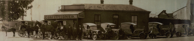
Photograph - Photograph - Black and White, Davies the Baker and Confectioner, 47 Eureka Street, Ballarat East, c1930, c1930
John Davies ran the bakery until 1923, at which time his son, Fred “F.T.” Davies, became proprietor. The business continued to grow under Fred, who turned it into one of the most successful industries in Ballarat. Fred fitted the bakery with a Perkins Continuous Oven, which was quite revolutionary for the time. The bakery was also fitted with Scotch ovens, which were used for ordinary bread-baking, and were worked manually. (https://bih.federation.edu.au/index.php/Davies_Bread)A number of horse drawn carriages, and motor vans in front of a building at 47 Eureka Street known as Davies the Baker. The three men standing together are Frederick Talbot Davies, John Davies and Hector Godfrey Smith (foreman). davies, davies bread, davies the baker, eureka street, horse, horse drawn carriage, confectioner -
 Federation University Historical Collection
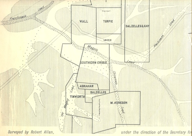
Plan, Underground Survey of Mines, Ballarat East, 1885, 09/1889
Surveyed by Robert Allan under the direction of the Secretary of Mines.Rectangular plan showing placement of mines in 1889. Mines include Hick's and Gilpin's lease, Comstock, Melbourne Company, Victoria United, Speedwell Company, New Normanby, Pasha Surprise, Central Sulieman, West Llanberris, Britannia United, Victoria Unites, Clinton's, Orient Company, North Sulieman, Sulieman Extended, Pasha Surprise, Golden Fountain, Prince regent, Clark and Company, Tinworth, North Woah Hawp, Detering, R.A. Thompson, Dazelles and buchanan, Barnett, Braybrook, Ladt Cornwall, Hanthorne, Dalzelles and gay, Southern Cross, M. Acheson, Cricket Reserveballarat east, mines, mining, underground survey, robert allan, chinese, ah chong, ah young, bakery hill, black hill, black hill lead, bakery hill lead, cricket, pennyweight hill, gravel pitts lead, golden point lead, navy jack's lead, mopoke lead, eureka lead, association lead, warrenheip lead, cgt, plans -
 Federation University Historical Collection
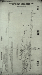
Plan, Underground Survey of Mines, Ballarat East. The Victoria United Company, 1903
Underground Survey of The Victoria United Company from Geological Survey of Victoria, Memoirs No. 4.ballarat east, victoria united company, cgt, mining, geological survey, longitudinal section -
 Federation University Historical Collection
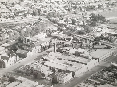
Photograph - Photograph - Black and White, Aerial Photograph of the Ballarat School of Mines and Ballarat East, Pre 1967
Black and white aerial photograph of the Ballarat School of Mines, White Flat Oval, Ballarat Gaol, Ballarat Brewery, Ballarat Club, Uniting Church, John Valves (Lydiard Street), Ballarat Girls' Technical School and Ballarat ballarat gaol, white flat, ballarat uniting church, ballarat girls' technical school, armstrong street south, lydiard street south, yarrowee channel, humffray street south, m.b. john, john valves, former ballarat gaol, ballarat brewery, dana street, grant street, lydiards street south, white flat oval, aerial photograph -
 Federation University Historical Collection
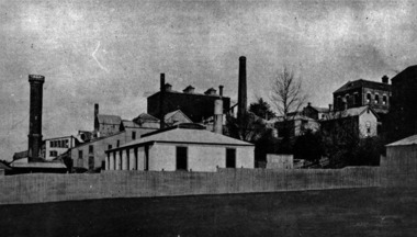
Photograph - Black and White, Ballarat School of Mines from the north-east corner, c1917
.1) Ballarat School of Mines buildings from Dana Street, near Albert Street, Ballarat showing Caselli's Gauge Tower, Administration Building, and Model Mine. .2) similar view to .1) but showing more foreground and additional buildings, c1917henry richards caselli, gauge tower, ballarat school of mines, dana street, albert street, model mine, mining laboratory -
 Federation University Historical Collection
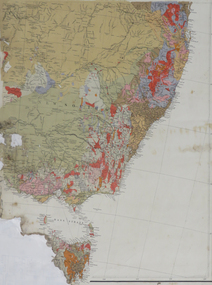
Map, South East Australia, not dated
Printed colour maptasmania, new south wales, victoria -
Federation University Historical Collection
Plan, Barkly Street Campus, Ballarat East, c1950s ?
Ink on paper plan: Barkly Street Campus. plans, barkly street campus, ballarat east, ballarat girls', ballarat girls' secondary school -
 Federation University Historical Collection
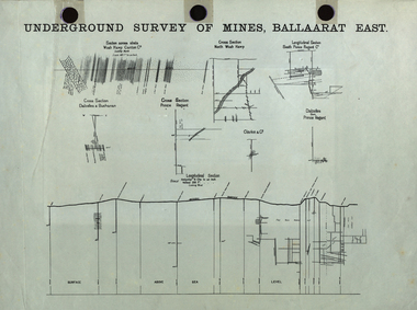
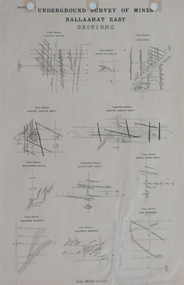
Plan, Underground Survey of Mines, Ballaarat East Sections, c1890
Printed plan showing cross sections of various mine shaftsplan, underground survey, ballaarat east, mining -
 Ringwood and District Historical Society
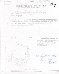
Document, Partial copy of Certificate of Title Vol 7635 Fol 096 Lot 29, 44 Sunbeam Avenue Ringwood East, Victoria
Black and white photocopied page with added notations in blue pen.Ellen Elizabeth Stanton, Married Woman of 35 Bell Street Richmond is now the Proprietor of an estate in Fee-simple, subject to the Encumbrances notified herunder in the surface down to the depth of fifty feet below the surface of the pie of land delineated and colored red purple and blue on the map in the margin, being Lot 29 Parish of Ringwood. Plan of Subdivision No. 12150. (undated). -
 Ringwood and District Historical Society
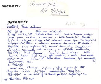
Newspaper, The Mail, Obit for James Leishman Skerrett, East Ringwood Storekeeper. Associated with Blood Bros
Refer to Ringwood Mail, died 7 November 1963