Showing 4874 items
matching access
-
 Ballarat Tramway Museum
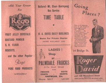
Ephemera - Timetable, H. A. Davis Motor Services, timetables for H. A. Davis Motor Service, mid 1940's?
Has a strong association with Davis Bus lines and the services they provided in the 1940's/Set of two timetables for H. A. Davis Motor Service and Davis Bus Lines - mid 1940's? Both are printed on heavy card, folded into three with many advertisements for local suppliers. .1 - Ballarat - Mt Clear - Buninyong Bus Service - printed on orange coloured card. Times given for weekdays, Saturdays, Sundays and Public Holidays. .2 - Wendouree - Air Force Bus Service - services from the City to the Air Force camp at the Ballarat Airport. Services for Monday to Thursday, Friday, Saturday, Sunday and Public Holidays. The history of the Ballarat Airport - accessed 20-11-2016 - http://www.ballarat.vic.gov.au/ab/ballarat-airport/ballarat-airport-history.aspx gives detail of the Air Force use of the site from 1940 through to 1961. Timetable thought to during the war period, but may be later.buses, timetables, ballarat airport, raaf, buninyong, advertisements -
 Ballarat Tramway Museum
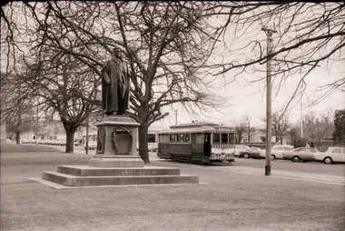
Negative - Set of 5, Campbell Duncan, 10/08/1971 12:00:00 AM
Yields information about tram operations and the street views in Sturt St near Lyons St.Set of 5 photographs taken on 10/8/1971 by Campbell Duncan of trams in Sturt St near Lyons St. .1 - No. 27 inbound with a Twin Lakes and destination of Mt Pleasant, passing the Peter Lalor statue in the median strip. .2 - No. 34 outbound crossing Dawson St with the Golden City Hotel in the background. .3 - No. 21 outbound with St Patrick's Cathedral in the background and the Adam Lindsay Gordon statue (1969) memorial to the horses killed in the First World War. 4. ditto .5 - No. 13 inbound with a Twin Lakes sign and destination of Victoria St, crossing Lyons St, with St Andrews Kirk in the background. For notes on the statues see: http://www.ballarat.vic.gov.au/media/499947/sturt%20street%20gardens%20calm%20plan.pdf (accessed 11/12/16)trams, tramways, sturt st, dawson st, lyons st, statues, tram 27 tram 34 tram 21 -
 Ballarat Tramway Museum
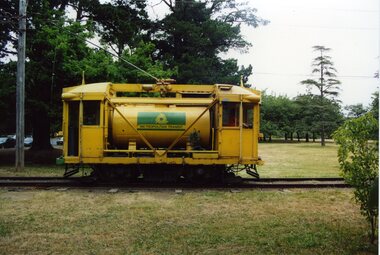
Photograph - Colour Photograph/s - set of 10, Warren Doubleday, 20/01/2002 12:00:00 AM
Set of 10 colour photographs / prints of Scrubber 8 in Wendouree Parade and depot track on 20/1/2002, working and testing the sprinkler bar on No. 1 end of the tram. Photos by Warren Doubleday. On Kodak paper. 1962.1 - Scrubber 8 on access track .2 - At depot junction, with 45 behind, ice cream van alongside. .3 - With sprinkler bar operating .4 - ditto .5 - ditto .6 - showing the very end of the sprinkler bar under No. 1 end, at the back of the flusher hood. .7 - showing the valve and water line for the sprinkler bar. .8 - ditto .9 - showing the watered roadway coming down into depot junction from Carlton St. .10 - Simon Green cleaning depot junction points. (Photo used in Jan. 2002 Fares Please!) On .10 only in blue ink, date "20/1/02" scrubber tram, btm, sprinkler bar, depot junction, tram 8 -
 Ballarat Tramway Museum
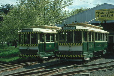
Photograph - Digital image Set of 16, Warren Doubleday, 5/10/1975 12:00:00 AM
Set of 16 digital images of BTPS Operations on 5-10-1975 during the time of the SPER (Sydney Tramway Museum) visit to Ballarat. .1 - 14 and 27 on the depot fan .2 - 27 and 14 on the access track about to cross Wendouree Parade .3 - ditto with 40 in Wendouree Parade .4 - 26 swinging the pole in Wendouree Parade .5 - three single truckers in the Loop .6 - ditto .7 - 14 in the loop .8 - 40 near depot junction .9 - 27 running into the loop. 10 - All four cars in or nearing the loop 11 - ditto 12 - 26 side on view 13 - 26 Gardens North 14 - 14 Gardens North 15 - 14 and 26 descending from Carlton St 16 - 26 dittotrams, tramways, btps, sper, wendouree parade, depot, gardens loop, tram 14, tram 26, tram 27, tram 40 -
 Kew Historical Society Inc
Photograph - 'Fernhurst', 13 Fernhurst Grove, 1978
George Wharton arrived in Melbourne in 1844. An architect and surveyor, he was appointed to lay out the 'Village of Kew' by N.A. Fenwick following the land sales of 1851. A protagonist for Kew's separation from the Boroondara District Road Board, he was elected chairman when Kew achieved municipal status in December 1860. His home, 'Fernhurst', was built in 1866 on eight acres in Studley Park, with a four-storey tower and pyramidal roof. The Italianate home was a prominent Kew landmark. It was demolished in 1979 and replaced by St Paul's College in 1980.Rare colour photograph of what was once a significant mansion in Kew.Original colour positive photograph (Kodak print) of 'Fernhurst' in 1978. Photographed by Stewart West in May 1978, one year before it was demolished, the photograph gives little idea of the large landholding once surrounding the house. Originally accessed from near the corner of Princess Street and Studley Park Road, its gardens had been subdivided in the 1900s and its footprint restricted to 13 Fernhurst Grove. Like many other grand houses, by the 1970s it had been converted into apartments. From the photograph, one can see that the house had retained many of its original features such as the distinctive tower and the wide bow-fronted verandah. The slates on the roof (apart from those on the tower) had been replaced by tiles and the cement render of the exterior painted white. Annotated reverse: "View of Fernhurst Home Taken from Street / 10"fernhurst, 13 fernhurst grove -- kew (vic.), george wharton, italianate architecture, vila maria society, st paul's school for the blind -
 Kew Historical Society Inc
Photograph - 'Fernhurst', 13 Fernhurst Grove, 1978
George Wharton arrived in Melbourne in 1844. An architect and surveyor, he was appointed to lay out the 'Village of Kew' by N.A. Fenwick following the land sales of 1851. A protagonist for Kew's separation from the Boroondara District Road Board, he was elected chairman when Kew achieved municipal status in December 1860. His home, 'Fernhurst', was built in 1866 on eight acres in Studley Park, with a four-storey tower and pyramidal roof. The Italianate home was a prominent Kew landmark. It was demolished in 1979 and replaced by St Paul's College in 1980.Rare colour photograph of what was once a significant mansion in Kew.Original colour positive photograph (Kodak print) of 'Fernhurst' in 1978. Photographed by Stewart West in May 1978, one year before it was demolished, the photograph gives little idea of the large landholding once surrounding the house. Originally accessed from near the corner of Princess Street and Studley Park Road, its gardens had been subdivided in the 1900s and its footprint restricted to 13 Fernhurst Grove. Like many other grand houses, by the 1970s it had been converted into apartments. From the photograph, one can see that the house had retained many of its original features such as the distinctive tower and the wide bow-fronted verandah. The slates on the roof (apart from those on the tower) had been replaced by tiles and the cement render of the exterior painted white. Annotated reverse: "Fernhurst from higher ground level side shot / 7"fernhurst, 13 fernhurst grove -- kew (vic.), george wharton, italianate architecture, vila maria society, st paul's school for the blind -
 Kew Historical Society Inc
Photograph - 'Fernhurst', 13 Fernhurst Grove, 1978
George Wharton arrived in Melbourne in 1844. An architect and surveyor, he was appointed to lay out the 'Village of Kew' by N.A. Fenwick following the land sales of 1851. A protagonist for Kew's separation from the Boroondara District Road Board, he was elected chairman when Kew achieved municipal status in December 1860. His home, 'Fernhurst', was built in 1866 on eight acres in Studley Park, with a four-storey tower and pyramidal roof. The Italianate home was a prominent Kew landmark. It was demolished in 1979 and replaced by St Paul's College in 1980.Rare colour photograph of what was once a significant mansion in Kew.Original colour positive photograph (Kodak print) of 'Fernhurst' in 1978. Photographed by Stewart West in May 1978, one year before it was demolished, the photograph gives little idea of the large landholding once surrounding the house. Originally accessed from near the corner of Princess Street and Studley Park Road, its gardens had been subdivided in the 1900s and its footprint restricted to 13 Fernhurst Grove. Like many other grand houses, by the 1970s it had been converted into apartments. From the photograph, one can see that the house had retained many of its original features such as the distinctive tower and the wide bow-fronted verandah. The slates on the roof (apart from those on the tower) had been replaced by tiles and the cement render of the exterior painted white. Annotated reverse: "Back view of Fernhurst / 8"fernhurst, 13 fernhurst grove -- kew (vic.), george wharton, italianate architecture, vila maria society, st paul's school for the blind -
 Kew Historical Society Inc
Photograph - 'Fernhurst', 13 Fernhurst Grove, 1978
George Wharton arrived in Melbourne in 1844. An architect and surveyor, he was appointed to lay out the 'Village of Kew' by N.A. Fenwick following the land sales of 1851. A protagonist for Kew's separation from the Boroondara District Road Board, he was elected chairman when Kew achieved municipal status in December 1860. His home, 'Fernhurst', was built in 1866 on eight acres in Studley Park, with a four-storey tower and pyramidal roof. The Italianate home was a prominent Kew landmark. It was demolished in 1979 and replaced by St Paul's College in 1980.Rare colour photograph of what was once a significant mansion in Kew.Original colour positive photograph (Kodak print) of 'Fernhurst' in 1978. Photographed by Stewart West in May 1978, one year before it was demolished, the photograph gives little idea of the large landholding once surrounding the house. Originally accessed from near the corner of Princess Street and Studley Park Road, its gardens had been subdivided in the 1900s and its footprint restricted to 13 Fernhurst Grove. Like many other grand houses, by the 1970s it had been converted into apartments. From the photograph, one can see that the house had retained many of its original features such as the distinctive tower and the wide bow-fronted verandah. The slates on the roof (apart from those on the tower) had been replaced by tiles and the cement render of the exterior painted white. Annotated reverse: "Fernhurst front view taken from across Fernhurst Grove / 6"fernhurst, 13 fernhurst grove -- kew (vic.), george wharton, italianate architecture, vila maria society, st paul's school for the blind -
 Kew Historical Society Inc
Photograph - 'Fernhurst', 13 Fernhurst Grove, 1978
George Wharton arrived in Melbourne in 1844. An architect and surveyor, he was appointed to lay out the 'Village of Kew' by N.A. Fenwick following the land sales of 1851. A protagonist for Kew's separation from the Boroondara District Road Board, he was elected chairman when Kew achieved municipal status in December 1860. His home, 'Fernhurst', was built in 1866 on eight acres in Studley Park, with a four-storey tower and pyramidal roof. The Italianate home was a prominent Kew landmark. It was demolished in 1979 and replaced by St Paul's College in 1980.Rare colour photograph of what was once a significant mansion in Kew.Original colour positive photograph (Kodak print) of 'Fernhurst' in 1978. Photographed by Stewart West in May 1978, one year before it was demolished, the photograph gives little idea of the large landholding once surrounding the house. Originally accessed from near the corner of Princess Street and Studley Park Road, its gardens had been subdivided in the 1900s and its footprint restricted to 13 Fernhurst Grove. Like many other grand houses, by the 1970s it had been converted into apartments. From the photograph, one can see that the house had retained many of its original features such as the distinctive tower and the wide bow-fronted verandah. The slates on the roof (apart from those on the tower) had been replaced by tiles and the cement render of the exterior painted white. Annotated reverse: "Front view of Fernhurst showing tower to advantage / 9"fernhurst, 13 fernhurst grove -- kew (vic.), george wharton, italianate architecture, vila maria society, st paul's school for the blind -
 Kew Historical Society Inc
Photograph - 'Fernhurst', 13 Fernhurst Grove, 1978
George Wharton arrived in Melbourne in 1844. An architect and surveyor, he was appointed to lay out the 'Village of Kew' by N.A. Fenwick following the land sales of 1851. A protagonist for Kew's separation from the Boroondara District Road Board, he was elected chairman when Kew achieved municipal status in December 1860. His home, 'Fernhurst', was built in 1866 on eight acres in Studley Park, with a four-storey tower and pyramidal roof. The Italianate home was a prominent Kew landmark. It was demolished in 1979 and replaced by St Paul's College in 1980.Rare colour photograph of what was once a significant mansion in Kew.Original colour positive photograph (Kodak print) of 'Fernhurst' in 1978. Photographed by Stewart West in May 1978, one year before it was demolished, the photograph gives little idea of the large landholding once surrounding the house. Originally accessed from near the corner of Princess Street and Studley Park Road, its gardens had been subdivided in the 1900s and its footprint restricted to 13 Fernhurst Grove. Like many other grand houses, by the 1970s it had been converted into apartments. From the photograph, one can see that the house had retained many of its original features such as the distinctive tower and the wide bow-fronted verandah. The slates on the roof (apart from those on the tower) had been replaced by tiles and the cement render of the exterior painted white. Annotated reverse: "Fernhurst corner shot through trees / 12-22"fernhurst, 13 fernhurst grove -- kew (vic.), george wharton, italianate architecture, vila maria society, st paul's school for the blind -
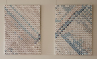 Federation University Art Collection
Mixed media, 'Line of Sight' by Debbie Lloyd, 2007
Debbie LLOYD Debbie Lloyd returned to study in 2005 completing a Bachelor of Fine Arts (Visual Arts) degree at the University of Ballarat (now Federation University) in 2007, with honours the following year. She returned to the university as Artist in Residence in 2009. During her time at the University Debbie exhibited in many group exhibitions and her work was selected for the National Graduates Show at PICA in Western Australia. Debbie’s first solo exhibition was held at Space22 in Ballarat, towards the end of 2010. This item is part of the Federation University Art Collection. The Art Collection features over 1000 works and was listed as a 'Ballarat Treasure' in 2007.Two artworks featuring a third dimension created with folded paper. Artist's Statement: "My artwork explores the visual experience that can be achieved using black and white, lineal patterns or by creating illusion and surface movement through the simple manipulation and repetition of forms. In these works I have used everyday objects, and shapes, repeated, reconfigured and recontextualised to provide the viewer with visual challenges that slow down and complicate the reading of the work. In the words of a former lecturer of mine, who kindly delivered the opening speech at one of my exhibitions – There is in Debbie’s work a belief in the transcendental power of repetition, a tribute in many respects to the fact that human kind is defined by nothing more noble and uplifting than its ability and obligation to persist." (http://100thgallery.com/gallery/debbie-lloyd/, accessed 08 May 2018) art, artwork, debbie lloyd, available, recycling, envelopes -
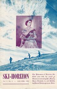 Falls Creek Historical Society
Journal - Ski-Horizon Vol 5 No 5, Jan - Feb 1954
Ski-Horizon is the official journal of the Federation of Victorian Ski Clubs which began publication in 1949. The were 26 original member clubs which included Albury Ski Club, Bogong Ski Club, Myrtleford Ski Club, Tallangatta and District Ski Club and Wangaratta Ski Club. Two pioneers of Falls Creek, Tom Mitchell, M.L.A., and Martin Romuld were Vice-Presidents of the Federation.This Journal is significant because it documents the early development of skiing in Victoria.The journal features stories and events chronicling developments in Victoria and internationally. Items related to the Falls Creek Area in this issue include:- The front cover featured an official portrait of Her Majesty Queen Elizabeth II who was visiting Victoria with H.R.H. the Duke of Edinburgh Page 13 - There were to be virtually no restrictions on access to Falls Creek for the summer. However visitors were asked to avoid using the road above Mt. Beauty between 7-8.30 a.m. and 4-5.30 p.m. Many clubs have been building at Falls Creek and there are many things to see, including the Kiewa hydroelectric scheme. At this stage, restrictions for winter use have not been revealed. Unless major works resume on the hydroelectric scheme it is unlikely the road will be open beyond Howman's Gap.falls creek access, sec road access, royal visit -
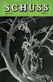 Falls Creek Historical Society
Journal - Schuss Vol. 19. No. 3 May 1953
Schuss was advertised as Victoria’s Official Ski Journal It was issued monthly from 1935 to 1961 except during the war when summer issues covered two months. This continued after the war, but it averaged 10 issues annually over its 25 year life. Schuss was published by the Ski Club of Victoria which had a membership of 38 Ski Clubs and demanded to be recognised as the prime authority on skiing in the state. The other 30 ski clubs with 85% of the members disagreed and the politics of skiing became heated. These clubs formed the Federation of Victorian Ski Clubs with their own journal, Ski Horizon. With the establishment of the Victorian Ski Association, Ski-Horizon published its last issue in Nov - Dec. 1955 and the role of the official journal was fully taken over by “Schuss”. This item is significant because it contains stories, images and information documenting the development of the ski industry in Victoria.The journal features stories and events chronicling developments in Victoria and internationally. Items related to the Falls Creek Area in this issue include:- Page 88 - BOOKINGS AVAILABLE AT SKYLINE LODGE July snow conditions are well-known to experienced skiers for their dry powder surfaces, fast running and reasonable weather generally. The lower mid-winter temperatures are mainly responsible for the crisp skiing atmosphere offered us during that month. It is surprising therefore to find that bookings for July this year are unusually light at all Victorian resorts. Skyline Lodge in particular, with its good transport, easy access, and usually abundant snow cover has everything to offer keen skiers: at present there are vacancies in its booking list through the month. Why ret sample is delightful skiing?schuss journal, the ski club of victoria, skyline -
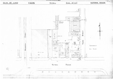 Melbourne Tram Museum
Drawing, Melbourne & Metropolitan Tramways Board (MMTB), "Victoria Parade", "Rae St Fitzroy", c1938
Set of three photocopied plans or drawings on A3 sheet of the "Victoria Parade" and "Rae St Fitzroy", c/1938. .1 - sheet 1 - P8396 - showing layout of buildings, adjacent properties at the intersection of Victoria Parade and Young Street - includes the offices, sub-station and shedding and location of No. 95 Victoria Parade - sheet 2 - P8397 - shows details of No. 95 Victoria Parade and the Two story Traffic offices at the corner of Young and Victoria Parade. .2 - P8405 - Plan of property - block and buildings of No. 449 Rae St Fitzroy. A web search shows that an advertisement was placed for the Carowindra Private Hospital at this location - advertised in the Fitzroy City Press - 14/2/1920 - Trove - access 12-9-2016. This became part of the Central Bus Garage property - see Reg Item 1745.trams, tramways, drawings, depots, property, victoria parade, young st, substation, hospital -
 Melbourne Tram Museum
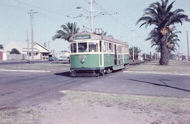
Slide, Keith Caldwell, 12/03/1960 12:00:00 AM
Agfa Colour slide, cardboard mount, by Keith Caldwell dated 12 March 1960, of W5 818 running in Mount Alexander Road, North Essendon, crossing the street access for Marco Polo Street. The tram showing route 59, Essendon Aerodrome, has trolley wheels and has a second person in the cab, possibly a trainer. Unusually the tram number is placed above the headlight, In the background are the palm trees in the centre median plantation. The house with the red guttering is one that dates back to the gold mining era. See http://www.esshissoc.org.au/1070%20Mount%20Alexander%20Road.pdf It was relocated to Woodland Park during 2017? Note the Centre poles, overhead construction and street light. Also in the background is a Mobil Service station that later became a garden centre. Now a block of apartments.hand stamped "12 Mar '60"trams, tramways, mount alexander rd, north essendon, essendon airport, essendon aerodrome, route 59, w5 class, tram 818 -
 Melbourne Tram Museum
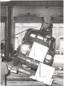
Photograph - Set of 7 Black & White Photograph/s, Melbourne & Metropolitan Tramways Board (MMTB), c1969 - 1970
Series of six black and white photographs of fire trucks being tested for the roll over characteristics. .1 - .3 - Metropolitan Fire Brigade Board (Melbourne - MFBB) appliance or fire truck or pumper, being tested at Preston Workshops. Based on the number plate in .1 - c1969 - 1970 see https://en.wikipedia.org/wiki/Vehicle_registration_plates_of_Victoria (accessed 22/4/2020) The facility appears to be long enough to test a bus, but appears to be one that was stored and then brought out for use. .4 to .6 are of testing a UK truck on a more dedicated facility. .7 - workers, some ex MFB workshops possibly, winching ropes. A copy of the Newsletter of the Fire Services Museum of Vic. 9/2021 featured some of these photos. Item stored in box 192 with the photographs.trams, tramways, preston workshops, mfbb, testing -
 Melbourne Tram Museum
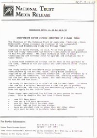
Document - Press Release, National Trust, "National Trust media release - Independent report favours retention of W-class trams", 18/08/1993 12:00:00 AM
Press Release - 12 A4 photocopied pages, stapled in top left hand corner, titled "National Trust media release - Independent report favours retention of W-class trams", dated 18/8/1993. Press release supports the retention of W class trams over Z class trams, references a report by Ove-Arup and Cam Com. Provides quotes from Simon Molesworth, Chairman of the Trust's W Class Tram committee, Don Gibson. Provides copy of Report - looks at cost of maintaining and operating W and Z class trams. No reference to other types of trams. Gives history of the trams, notes withdrawal from service, spare parts, storage in North Melbourne. No mention of low floor trams or disability access.In top Right hand corner in ink "KS 9-9-93"trams, tramways, w class, scrapped trams, national trust -
 Melbourne Tram Museum
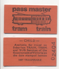
Ephemera - Ticket/s, Victorian Railways, Pass Master, 1976
Ticket - Pass Master - printed on paste board - Edmondson style, bright orange colour with a drawing of a Z class and Hitachi train and the words "Pass Master" and "Tram Train". On rear are conditions of travel, Child, available on tram, train and bus on the date stamped. Ticket numbers 02404, 02456, 02476 3 copies held. Further copies added 17/8/2014 from the Robert Green collection. Child - 90828 Concession - 22686 3 x Adults - wrapped in a taped section of yellow paper - 13448, 07421, 04569. 3 x Adults - ditto, 13460, 07414, 04367 For more detail see http://www.robx1.net/victkt/pre1981/html/1976.htm - accessed 7-11-2018, started 1976The two parcels of wrapped tickets both have the numbers "55" written on them.trams, tramways, tickets, children, pass master, melbourne -
 Melbourne Tram Museum
Photograph - Colour photograph - mounted, Yarra Trams or PTC?, mid 1990's?
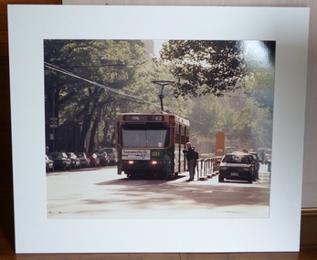
Colour print mounted within a large card frame of A class 281, westbound on Collins St at the Exhibition St stop. Tram has the destination of City, Route 42 and an Advertisements for Ford exhaust systems. In the driver's window is the run number "K38" Behind the tram is a W class tram that appears to be showing route 17. Photo could be early 1990's, route 42 became route 109 in 2003 when the extension opened to Box Hill. Route 17 ran until 2/1997. Having a run number will also assist in dating the photograph. (reference 'tramroutenumbers.pdf accessed from Yarra trams web site.) Has been wall mounted or mounted within a larger frame - tape tear marks on the rear.trams, tramways, collins st, a class, tram 281 -
 Melbourne Tram Museum
Photograph - Colour photograph - mounted, Yarra Trams or PTC?, mid 1990's?
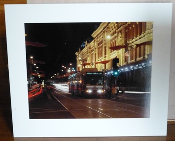
Colour print mounted within a large card frame of B class 2050 inbound on Flinders St to Latrobe St running a route 75. Has a Bank of Melbourne advertisement on the front of the tram, along with a run on its side in the front window. Tram at the Elizabeth St stop with Flinders St station in the background. In Flinders St, Christmas decorations have been strung on the span wire. Has been wall mounted or mounted within a larger frame - tape tear marks on the rear. The Wikipedia page for Bank of Melbourne (accessed 3/12/14 - http://en.wikipedia.org/wiki/Bank_of_Melbourne_%281989%29) - The Bank of Melbourne is a financial institution based in Melbourne, Australia, established in 1989 and taken over by the Westpac Banking Corporation (Westpac) in 1997.trams, tramways, collins st, b class, tram 2050 -
 Federation University Historical Collection
Poster, Fed Pride Poster, 2022
FedPride 2021-2024 is a comprehensive strategy, aimed at achieving best inclusive practice in every area of university life: from recruitment and enrolment, to our culture, campuses, how we engage with the communities where our campuses are located and importantly through our curriculum and research. We know that diversity – having access to and embracing difference in backgrounds, perspectives, knowledge and skills – gives our university a breadth that supports innovation and the highest quality of thinking. It enriches us as individuals and as a community. FedPride has a particular focus on our staff and students being able to bring their whole selves to university life. When we feel safe, included and celebrated, we contribute freely and with enthusiasm and bring the best of ourselves to work and study. FedPride is an intersectional strategy, in that the rights, inclusion and access of people from diverse cultural backgrounds, people with disability and Aboriginal and Torres Strait Islander Peoples are held as core to every impact area. FedPride 2021–2024 has been developed with consultation across the University. The strategy is led by the FedPride Steering Group and implemented and monitored by the Implementation Group. Reports to measure progress will be provided annually for the Vice-Chancellor’s Senior Team. FedPride is endorsed by the Vice-Chancellor and the Vice-Chancellor’s Senior Team.A3 poster publicising Fed Pride. This poster was displayed at all Federation University posters in 2022.fed pride, equity -
 Ballarat Tramway Museum
Administrative record - Memorandum, Hal Cain, moving of trams to the new depo, Dec. 1971
Copies of reports and notes prepared by Hal Cain on the moving of trams to the new depot, depot access track construction and the construction of the depot. All on foolscap sheets, toner photocopies, with punched holes on the left hand edge. 914.1 - copy of a memo on the method of moving tramcars from the old SEC Depot to the Society's new building. Written on BTPS letterhead (see item 913) over two sheets of paper. Photocopied onto a single foolscap sheet of paper. In top right hand corner has notation "written by HAL 22/12/71". Last point - number 9 did not copy well and has lost most of last line - see 914.2 (Note by WAD - basis of method used for the movement of the first tram, but found to be very difficult and likely to damage the tramcars. Led to the laying of a temporary access track to the edge of the Wendouree Parade, which was used for the movement of the following five tramcars.) 914.2 - as for 914.1 but includes good text of point 9. 914.3 - copy of a report written by Hal Cain about the "Construction of connecting track in South Gardens Reserve from the Society's Depot to Wendouree Parade". On foolscap paper, with two punch holes in the left hand edge. In top right hand corner has notation "written by HAL 22/12/71". (two copies held) 914.4 - copy of a report written by Hal Cain on the: a - quotation received by the Society for the erection of the its Tram Depot b - Formation of the BTPS Cooperative c - Progress of the Preservation Society to date. On foolscap paper, with two punch holes in the left hand edge. In top right hand corner has notation "written by HAL 22/12/71". (two copies held) trams, tramways, btps, btps depot, track construction, btps co-operative -
 Melbourne Tram Museum
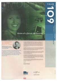
Newsletter, Yarra Trams, "Tram 109", 2001 - 2003
Set of three A4 printed newsletters, stapled in top left hand corner, titled "Tram 109" and two associated pamphlets. .1 - 4 pages - issue 1 - September 2001 - with introduction by Minister for Transport Peter Batchelor introducing the new route 109, Hubert Guyot (CEO Yarra Trams) about the Superstops, details of the new low floor trams and details of the extension to Box Hill along with time line. .2 - 4 pages - issue 2 - Autumn 2002 - message from CEO, diagrammatic map and attributes, and a general update on progress, including a timeline. .3 - single folded A3 sheet printed both sides - Issue 4 - Summer 2003 - noting the wheel chair access to tram, opening on 2/5/2003, message from CEO and launch details, including notes on patronage increase. .4 - Pamphlet - DL four fold - printed on gloss paper full colour dated Autumn 2002 with message from Minister for Transport Peter Batchelor, diagrammatic map of extension showing tram stop facilities and locations of important places, low floor trams and contact details for further information. .5 - Pamphlet - DL five fold - printed on gloss paper full colour dated c mid 2001 with message from Minister for Transport Peter Batchelor, details of Yarra Trams, why the extension and project map. Has Harry the Yarra Trams Infrastructure Mascot. .6 - Pamphlet - 4 fold A4 landscape - printed both sides, issue 3, noting the need for universal access, St Vincent's plaza upgrade and tram stop options.trams, tramways, yarra trams, route 109, box hill, mont albert, superstops, tram stops, opening, st vincent's plaza -
 Eltham District Historical Society Inc
Photograph, Former Eltham Police Residence, 728 Main Road, Eltham, c.1985, 1985c
This photo is believed to have been taken circa 1985 when the Shire of Eltham Parks and Environment occupied the site. This photo was originally mounted on 3mm MDF fibre board with notes and stickers applied as part of a display on the former Police Residence and now present day Local History Centre, home to Eltham District Historical Society; possibly put together by Harry Gilham during his time as president of the society. Eltham Police Station and Residence: A brief history 1860 Eltham Courthouse built in Main Road, together with an adjoining police residence, office, lock–up and stables. 1959 Police Department purchases a house in Pryor Street to be refurbished as Eltham Police Station 1961 Police in Eltham move into Pryor Street refurbished buildings and office. c.1961-1981 Occupied by Vermin and Noxious Weeds Destruction Section of the Department of Crown Lands and Survey. Former Police Station dragged around to rear of Police Residence (prior to August 1967) to make way for the construction of a driveway and access from Main Road. The building was placed on the site of a former Scullery and modified for Lands Department use. 1981 Shire of Eltham take over management of old Police Residence in Eltham. It remains unoccupied for a period of time whilst its future is discussed in Council. 1981-1985 Used for community job creation scheme 1985 Shire of Eltham Parks and Environment occupy the residence. Council improve the driveway but later add a second rear access from Brougham Street due to the dangerous nature of the Main Road entrance. Also add a rear toilet facility between the Police Residence and former Police Station, which was doubling up as a lunch room. Council also commence discussions to re-establish a replica Police Station. c.1986 November. Former Police Station demolished; believed to have been suffering termite damage. c.1989 After some years of discussion a replica Police Station is built, based on photographs, to act as a lunch room and meeting room for Parks and Environment staff and volunteers doing community service. 1996 Eltham District Historical Society in discussions with Nillumbik Shire Council commisioners throughout the year regarding a home for the Society. A proposal put forward by the Society in October to occupy the former Police Residence. 1997 March. Eltham District Historical Society gains access to former Police Residence. 1998 July 12th. Eltham District Historical Society Inc moves into its Local History Centre, 728 Main Road Eltham (the former Police Residnce built in 1860). 2018 July. Eltham District Historical Society gains access to the replica Police Station for use as part of regular heritage tours for schools and community based groups.Colour printHandwritten in faded blue felt pen ink "No. 3 - Front of 728 Police Residence. 1860 Court House over the paling fence. Verandah missing from earlier photographs"728 main road, eltham, local history centre, parks and environment, police residence, police station, shire of eltham -
 Eltham District Historical Society Inc
Photograph, Former Eltham Police Residence, 728 Main Road, Eltham, c.1985, 1985c
This photo is believed to have been taken circa 1985 when the Shire of Eltham Parks and Environment occupied the site. This photo was originally mounted on 3mm MDF fibre board with notes and stickers applied as part of a display on the former Police Residence and now present day Local History Centre, home to Eltham District Historical Society; possibly put together by Harry Gilham during his time as president of the society. Eltham Police Station and Residence: A brief history 1860 Eltham Courthouse built in Main Road, together with an adjoining police residence, office, lock–up and stables. 1959 Police Department purchases a house in Pryor Street to be refurbished as Eltham Police Station 1961 Police in Eltham move into Pryor Street refurbished buildings and office. c.1961-1981 Occupied by Vermin and Noxious Weeds Destruction Section of the Department of Crown Lands and Survey. Former Police Station dragged around to rear of Police Residence (prior to August 1967) to make way for the construction of a driveway and access from Main Road. The building was placed on the site of a former Scullery and modified for Lands Department use. 1981 Shire of Eltham take over management of old Police Residence in Eltham. It remains unoccupied for a period of time whilst its future is discussed in Council. 1981-1985 Used for community job creation scheme 1985 Shire of Eltham Parks and Environment occupy the residence. Council improve the driveway but later add a second rear access from Brougham Street due to the dangerous nature of the Main Road entrance. Also add a rear toilet facility between the Police Residence and former Police Station, which was doubling up as a lunch room. Council also commence discussions to re-establish a replica Police Station. c.1986 November. Former Police Station demolished; believed to have been suffering termite damage. c.1989 After some years of discussion a replica Police Station is built, based on photographs, to act as a lunch room and meeting room for Parks and Environment staff and volunteers doing community service. 1996 Eltham District Historical Society in discussions with Nillumbik Shire Council commisioners throughout the year regarding a home for the Society. A proposal put forward by the Society in October to occupy the former Police Residence. 1997 March. Eltham District Historical Society gains access to former Police Residence. 1998 July 12th. Eltham District Historical Society Inc moves into its Local History Centre, 728 Main Road Eltham (the former Police Residnce built in 1860). 2018 July. Eltham District Historical Society gains access to the replica Police Station for use as part of regular heritage tours for schools and community based groups.Colour printHandwritten in faded blue felt pen ink "No. 2 - Backyard of 728 #5 Weatherboard 'Office'. Note 1860 Court House over the fence."728 main road, eltham, local history centre, parks and environment, police residence, police station, shire of eltham -
 Eltham District Historical Society Inc
Photograph, Former Eltham Police Residence, 728 Main Road, Eltham, c.1985, 1985c
This photo is believed to have been taken circa 1985 when the Shire of Eltham Parks and Environment occupied the site. This photo was originally mounted on 3mm MDF fibre board with notes and stickers applied as part of a display on the former Police Residence and now present day Local History Centre, home to Eltham District Historical Society; possibly put together by Harry Gilham during his time as president of the society. Eltham Police Station and Residence: A brief history 1860 Eltham Courthouse built in Main Road, together with an adjoining police residence, office, lock–up and stables. 1959 Police Department purchases a house in Pryor Street to be refurbished as Eltham Police Station 1961 Police in Eltham move into Pryor Street refurbished buildings and office. c.1961-1981 Occupied by Vermin and Noxious Weeds Destruction Section of the Department of Crown Lands and Survey. Former Police Station dragged around to rear of Police Residence (prior to August 1967) to make way for the construction of a driveway and access from Main Road. The building was placed on the site of a former Scullery and modified for Lands Department use. 1981 Shire of Eltham take over management of old Police Residence in Eltham. It remains unoccupied for a period of time whilst its future is discussed in Council. 1981-1985 Used for community job creation scheme 1985 Shire of Eltham Parks and Environment occupy the residence. Council improve the driveway but later add a second rear access from Brougham Street due to the dangerous nature of the Main Road entrance. Also add a rear toilet facility between the Police Residence and former Police Station, which was doubling up as a lunch room. Council also commence discussions to re-establish a replica Police Station. c.1986 November. Former Police Station demolished; believed to have been suffering termite damage. c.1989 After some years of discussion a replica Police Station is built, based on photographs, to act as a lunch room and meeting room for Parks and Environment staff and volunteers doing community service. 1996 Eltham District Historical Society in discussions with Nillumbik Shire Council commisioners throughout the year regarding a home for the Society. A proposal put forward by the Society in October to occupy the former Police Residence. 1997 March. Eltham District Historical Society gains access to former Police Residence. 1998 July 12th. Eltham District Historical Society Inc moves into its Local History Centre, 728 Main Road Eltham (the former Police Residnce built in 1860). 2018 July. Eltham District Historical Society gains access to the replica Police Station for use as part of regular heritage tours for schools and community based groups.Colour printHandwritten in faded blue felt pen ink "Roof of room 5 (weatherboard office) and W.C. See No. 2 for another view"728 main road, eltham, local history centre, parks and environment, police residence, police station, shire of eltham -
 Eltham District Historical Society Inc
Photograph, Former Eltham Police Residence, 728 Main Road, Eltham, c.1985, 1985c
This photo is believed to have been taken circa 1985 when the Shire of Eltham Parks and Environment occupied the site. This photo was originally mounted on 3mm MDF fibre board with notes and stickers applied as part of a display on the former Police Residence and now present day Local History Centre, home to Eltham District Historical Society; possibly put together by Harry Gilham during his time as president of the society. Eltham Police Station and Residence: A brief history 1860 Eltham Courthouse built in Main Road, together with an adjoining police residence, office, lock–up and stables. 1959 Police Department purchases a house in Pryor Street to be refurbished as Eltham Police Station 1961 Police in Eltham move into Pryor Street refurbished buildings and office. c.1961-1981 Occupied by Vermin and Noxious Weeds Destruction Section of the Department of Crown Lands and Survey. Former Police Station dragged around to rear of Police Residence (prior to August 1967) to make way for the construction of a driveway and access from Main Road. The building was placed on the site of a former Scullery and modified for Lands Department use. 1981 Shire of Eltham take over management of old Police Residence in Eltham. It remains unoccupied for a period of time whilst its future is discussed in Council. 1981-1985 Used for community job creation scheme 1985 Shire of Eltham Parks and Environment occupy the residence. Council improve the driveway but later add a second rear access from Brougham Street due to the dangerous nature of the Main Road entrance. Also add a rear toilet facility between the Police Residence and former Police Station, which was doubling up as a lunch room. Council also commence discussions to re-establish a replica Police Station. c.1986 November. Former Police Station demolished; believed to have been suffering termite damage. c.1989 After some years of discussion a replica Police Station is built, based on photographs, to act as a lunch room and meeting room for Parks and Environment staff and volunteers doing community service. 1996 Eltham District Historical Society in discussions with Nillumbik Shire Council commisioners throughout the year regarding a home for the Society. A proposal put forward by the Society in October to occupy the former Police Residence. 1997 March. Eltham District Historical Society gains access to former Police Residence. 1998 July 12th. Eltham District Historical Society Inc moves into its Local History Centre, 728 Main Road Eltham (the former Police Residnce built in 1860). 2018 July. Eltham District Historical Society gains access to the replica Police Station for use as part of regular heritage tours for schools and community based groups.Colour printHandwritten in faded blue felt pen ink "Another view of north wall 728 No. 4. Taken from west end towards back yard"728 main road, eltham, local history centre, parks and environment, police residence, police station, shire of eltham -
 Eltham District Historical Society Inc
Photograph, Former Eltham Police Residence, 728 Main Road, Eltham, c.1985, 1985c
This photo is believed to have been taken circa 1985 when the Shire of Eltham Parks and Environment occupied the site. This photo was originally mounted on 3mm MDF fibre board with notes and stickers applied as part of a display on the former Police Residence and now present day Local History Centre, home to Eltham District Historical Society; possibly put together by Harry Gilham during his time as president of the society. Eltham Police Station and Residence: A brief history 1860 Eltham Courthouse built in Main Road, together with an adjoining police residence, office, lock–up and stables. 1959 Police Department purchases a house in Pryor Street to be refurbished as Eltham Police Station 1961 Police in Eltham move into Pryor Street refurbished buildings and office. c.1961-1981 Occupied by Vermin and Noxious Weeds Destruction Section of the Department of Crown Lands and Survey. Former Police Station dragged around to rear of Police Residence (prior to August 1967) to make way for the construction of a driveway and access from Main Road. The building was placed on the site of a former Scullery and modified for Lands Department use. 1981 Shire of Eltham take over management of old Police Residence in Eltham. It remains unoccupied for a period of time whilst its future is discussed in Council. 1981-1985 Used for community job creation scheme 1985 Shire of Eltham Parks and Environment occupy the residence. Council improve the driveway but later add a second rear access from Brougham Street due to the dangerous nature of the Main Road entrance. Also add a rear toilet facility between the Police Residence and former Police Station, which was doubling up as a lunch room. Council also commence discussions to re-establish a replica Police Station. c.1986 November. Former Police Station demolished; believed to have been suffering termite damage. c.1989 After some years of discussion a replica Police Station is built, based on photographs, to act as a lunch room and meeting room for Parks and Environment staff and volunteers doing community service. 1996 Eltham District Historical Society in discussions with Nillumbik Shire Council commisioners throughout the year regarding a home for the Society. A proposal put forward by the Society in October to occupy the former Police Residence. 1997 March. Eltham District Historical Society gains access to former Police Residence. 1998 July 12th. Eltham District Historical Society Inc moves into its Local History Centre, 728 Main Road Eltham (the former Police Residnce built in 1860). 2018 July. Eltham District Historical Society gains access to the replica Police Station for use as part of regular heritage tours for schools and community based groups.Colour printHandwritten in faded blue felt pen ink "Repeat view of No. 4 from external corner of weatherboard extn. Room 5"728 main road, eltham, local history centre, parks and environment, police residence, police station, shire of eltham -
 Eltham District Historical Society Inc
Photograph, Former Eltham Police Residence, 728 Main Road, Eltham, c.1985, 1985c
This photo is believed to have been taken circa 1985 when the Shire of Eltham Parks and Environment occupied the site. This photo was originally mounted on 3mm MDF fibre board with notes and stickers applied as part of a display on the former Police Residence and now present day Local History Centre, home to Eltham District Historical Society; possibly put together by Harry Gilham during his time as president of the society. Eltham Police Station and Residence: A brief history 1860 Eltham Courthouse built in Main Road, together with an adjoining police residence, office, lock–up and stables. 1959 Police Department purchases a house in Pryor Street to be refurbished as Eltham Police Station 1961 Police in Eltham move into Pryor Street refurbished buildings and office. c.1961-1981 Occupied by Vermin and Noxious Weeds Destruction Section of the Department of Crown Lands and Survey. Former Police Station dragged around to rear of Police Residence (prior to August 1967) to make way for the construction of a driveway and access from Main Road. The building was placed on the site of a former Scullery and modified for Lands Department use. 1981 Shire of Eltham take over management of old Police Residence in Eltham. It remains unoccupied for a period of time whilst its future is discussed in Council. 1981-1985 Used for community job creation scheme 1985 Shire of Eltham Parks and Environment occupy the residence. Council improve the driveway but later add a second rear access from Brougham Street due to the dangerous nature of the Main Road entrance. Also add a rear toilet facility between the Police Residence and former Police Station, which was doubling up as a lunch room. Council also commence discussions to re-establish a replica Police Station. c.1986 November. Former Police Station demolished; believed to have been suffering termite damage. c.1989 After some years of discussion a replica Police Station is built, based on photographs, to act as a lunch room and meeting room for Parks and Environment staff and volunteers doing community service. 1996 Eltham District Historical Society in discussions with Nillumbik Shire Council commisioners throughout the year regarding a home for the Society. A proposal put forward by the Society in October to occupy the former Police Residence. 1997 March. Eltham District Historical Society gains access to former Police Residence. 1998 July 12th. Eltham District Historical Society Inc moves into its Local History Centre, 728 Main Road Eltham (the former Police Residnce built in 1860). 2018 July. Eltham District Historical Society gains access to the replica Police Station for use as part of regular heritage tours for schools and community based groups.Colour printHandwritten in faded blue felt pen ink "Backdoor to residence. White paint still visible 2010 on brickwork"728 main road, eltham, local history centre, parks and environment, police residence, police station, shire of eltham -
 Eltham District Historical Society Inc
Photograph, Former Eltham Police Residence, 728 Main Road, Eltham, c.1985, 1985c
This photo is believed to have been taken circa 1985 when the Shire of Eltham Parks and Environment occupied the site. This photo was originally mounted on 3mm MDF fibre board with notes and stickers applied as part of a display on the former Police Residence and now present day Local History Centre, home to Eltham District Historical Society; possibly put together by Harry Gilham during his time as president of the society. Eltham Police Station and Residence: A brief history 1860 Eltham Courthouse built in Main Road, together with an adjoining police residence, office, lock–up and stables. 1959 Police Department purchases a house in Pryor Street to be refurbished as Eltham Police Station 1961 Police in Eltham move into Pryor Street refurbished buildings and office. c.1961-1981 Occupied by Vermin and Noxious Weeds Destruction Section of the Department of Crown Lands and Survey. Former Police Station dragged around to rear of Police Residence (prior to August 1967) to make way for the construction of a driveway and access from Main Road. The building was placed on the site of a former Scullery and modified for Lands Department use. 1981 Shire of Eltham take over management of old Police Residence in Eltham. It remains unoccupied for a period of time whilst its future is discussed in Council. 1981-1985 Used for community job creation scheme 1985 Shire of Eltham Parks and Environment occupy the residence. Council improve the driveway but later add a second rear access from Brougham Street due to the dangerous nature of the Main Road entrance. Also add a rear toilet facility between the Police Residence and former Police Station, which was doubling up as a lunch room. Council also commence discussions to re-establish a replica Police Station. c.1986 November. Former Police Station demolished; believed to have been suffering termite damage. c.1989 After some years of discussion a replica Police Station is built, based on photographs, to act as a lunch room and meeting room for Parks and Environment staff and volunteers doing community service. 1996 Eltham District Historical Society in discussions with Nillumbik Shire Council commisioners throughout the year regarding a home for the Society. A proposal put forward by the Society in October to occupy the former Police Residence. 1997 March. Eltham District Historical Society gains access to former Police Residence. 1998 July 12th. Eltham District Historical Society Inc moves into its Local History Centre, 728 Main Road Eltham (the former Police Residnce built in 1860). 2018 July. Eltham District Historical Society gains access to the replica Police Station for use as part of regular heritage tours for schools and community based groups.Colour printHandwritten in faded blue felt pen ink "No. 1 South wall of 728 & back of house built 1860 [1859]. Demolition of weatherboard extension into yard area"728 main road, eltham, local history centre, parks and environment, police residence, police station, shire of eltham