Showing 5859 items
matching farms
-
 Churchill Island Heritage Farm
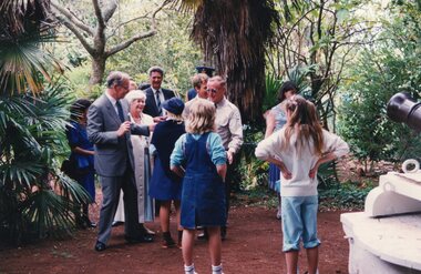
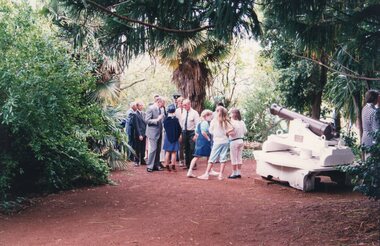
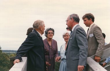
Photograph - Photograph of group standing in front of the cannon, 1988
Churchill Island Heritage Farm has a large photograph collection dating from the late nineteenth century. This series shows the long involvement and contribution to the community that occurred over the last three decades and the visit to Churchill Island by governor-general, Sir Ninian Stephen and his wife.Photograph of group of people gathered together talking in front of the Churchill Island cannonVISIT BY LADY + SIR NINIAN STEPHEN TO C.I./1988 [handwritten on reverse in pen] Catalogue number written on reverse in pencilchurchill island, photograph, governor-general, ninian stephen -
 Churchill Island Heritage Farm
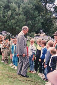
Photograph - Photograph of man greeting a line of children, 1988
Churchill Island Heritage Farm has a large photograph collection dating from the late nineteenth century. This series shows the long involvement and contribution to the community that occurred over the last three decades and the visit to Churchill Island by governor-general, Sir Ninian Stephen and his wife.Photograph of man (Sir Ninian Stephen) greeting a line of boys gathered on a paddock with agapanthus in the backgroundSIR NINIAN STEPHEN TALKS/TO CUBS, C.I. 1988 [handwritten on reverse in pen] Catalogue number written on reverse in pencilchurchill island, photograph, governor-general, ninian stephen -
 Churchill Island Heritage Farm
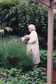
Photograph - Photograph of a woman standing in the garden, 1988
Churchill Island Heritage Farm has a large photograph collection dating from the late nineteenth century. This series shows the long involvement and contribution to the community that occurred over the last three decades and the visit to Churchill Island by governor-general, Sir Ninian Stephen and his wife.Photograph of a woman (Lady Stephen) holding a bouquet and standing in the garden behind a lavender bush.LADY STEPHEN IN C.I./GARDEN 1988 [handwritten on reverse in pen] Catalogue number written on reverse in pencilchurchill island, photograph, governor-general, ninian stephen -
 Churchill Island Heritage Farm
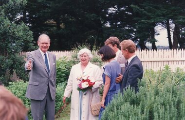
Photograph - Photograph of five people standing in a garden, 1988
Churchill Island Heritage Farm has a large photograph collection dating from the late nineteenth century. This series shows the long involvement and contribution to the community that occurred over the last three decades and the visit to Churchill Island by governor-general, Sir Ninian Stephen and his wife.Photograph of five people (Sir Ninian and Lady Stephen, Lisa Price, Cr Greg Price, Cr Stan Gates) standing in the Churchill Island garden amongst rosemary bushesL-R/SIR NINIAN + LADY STEPHEN, LISA/PRICE, CR GREG PRICE, SHIRE OF PI PRES/CR STAN GATES 1988 [handwritten on reverse in pen] Catalogue number written on reverse in pencilchurchill island, photograph, governor-general, ninian stephen -
 Churchill Island Heritage Farm
Photograph - Photograph of group gathered in front of the cannon, 1988
Churchill Island Heritage Farm has a large photograph collection dating from the late nineteenth century. This series shows the long involvement and contribution to the community that occurred over the last three decades and the visit to Churchill Island by governor-general, Sir Ninian Stephen and his wife.Photograph of a group of adults and children gathered together talking, in front of the Churchill Island cannonVISIT TO C.I. BY SIR NINIAN + LADY/STEPHEN1988 [handwritten on reverse in pen] Catalogue number written on reverse in pencilchurchill island, photograph, governor-general, ninian stephen -
 Churchill Island Heritage Farm
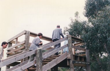
Photograph - Photograph of people climbing stairs to a viewing platform, 1988
Churchill Island Heritage Farm has a large photograph collection dating from the late nineteenth century. This series shows the long involvement and contribution to the community that occurred over the last three decades and the visit to Churchill Island by governor-general, Sir Ninian Stephen and his wife.Photograph of four people (Grant Membry, Christine Grayden, Sir Ninian Stephen, Lady Stephen) climbing stairs to the Jack Oswin viewing platform.GRANT MEMBRY, CHRISTINE GRAYDEN,/SIR NINIAN STEPHEN, LADY STEPHEN 1988 [handwritten on reverse in pen] Catalogue number written on reverse in pencilchurchill island, photograph, governor-general, ninian stephen -
 Churchill Island Heritage Farm
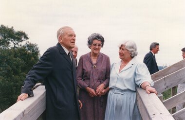
Photograph - Photograph of people standing on a wooden walkway, 1988
Churchill Island Heritage Farm has a large photograph collection dating from the late nineteenth century. This series shows the long involvement and contribution to the community that occurred over the last three decades and the visit to Churchill Island by governor-general, Sir Ninian Stephen and his wife.Photograph of three people (Jack Oswin, Coral Oswin, and Lady Stephen) standing and talking in the foreground on a wooden walkway, and a group of people gathered in the background.JACK OSWIN, CORAL OSWIN, LADY STEPHEN/AT CONSERVATION HILL VIEWING PLATFORM [handwritten on reverse in pen] Catalogue number written on reverse in pencilchurchill island, photograph, governor-general, ninian stephen -
 Churchill Island Heritage Farm
Photograph - Photograph of people standing on a wooden walkway, 1988
Churchill Island Heritage Farm has a large photograph collection dating from the late nineteenth century. This series shows the long involvement and contribution to the community that occurred over the last three decades and the visit to Churchill Island by governor-general, Sir Ninian Stephen and his wife.Photograph of three people (Jack Oswin, Coral Oswin, and Lady Stephen) standing and talking in the foreground on a wooden walkway, and a group of people gathered in the background.JACK OSWIN, CORAL OSWIN,/LADY STEPHEN/1988 [handwritten on reverse in pen] Catalogue number written on reverse in pencilchurchill island, photograph, governor-general, ninian stephen -
 Churchill Island Heritage Farm
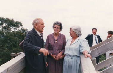
Photograph - Photograph of group of people standing on a walkway, 1988
Churchill Island Heritage Farm has a large photograph collection dating from the late nineteenth century. This series shows the long involvement and contribution to the community that occurred over the last three decades and the visit to Churchill Island by governor-general, Sir Ninian Stephen and his wife.Photograph of group of people (including Jack Oswin, Coral Oswin, Lady Stephen &Sir Ninian Stephen, and Cr Greg Price) standing and talking in the foreground on a wooden walkway.JACK OSWIN, CORAL OSWIN, LADY STEPHEN,/SIR NINIAN STEPHEN, CR GREG PRICE [handwritten on reverse in pen] 3 [handwritten on reverse in pen] Catalogue number written on reverse in pencilchurchill island, photograph, governor-general, ninian stephen -
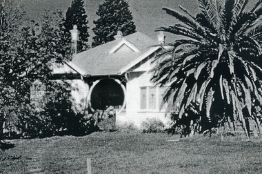
 Whitehorse Historical Society Inc.
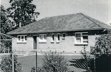
Photograph, Eckermann's home, c1960
Photographs relate to the Poultry Farms that existed in Nunawading and Forest Hill in the1950s and 1960s. Photos taken in 1961-62. Poultry farmers included Messrs Boyce, Gallos, Foote,Grimsley, Greenwood and Dudley|Slides scanned as a 'tiff' at 300dpi to CD Rom and cleaned and adjusted by Ted Arrowsmith.Mr & Mrs. Eckermann's house at 149 Mt Pleasant Road, Forest Hill. Taken from behind 1st pen.eckermann's, eckermann frank, poultry farms, nunawading, greenwood, forest hill, canterbury road, mount pleasant road nunawading, boyles, white, bruer's -
 Whitehorse Historical Society Inc.
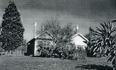
Photograph, The Greenwood's Home, c1960
Photographs relate to the Poultry Farms that existed in Nunawading and Forest Hill in the1950s and 1960s. Photos taken in 1961-62. Poultry farmers included Messrs Boyce, Gallos, Foote,Grimsley, Greenwood and Dudley|Slides scanned as a 'tiff' at 300dpi to CD Rom and cleaned and adjusted by Ted Arrowsmith.Mr. Greenwood's home in Canterbury Road near Brentford Square. They were poultry farmers from 1920 to 1960s.eckermann's, eckermann frank, poultry farms, nunawading, greenwood, forest hill, canterbury road, mount pleasant road nunawading, boyles, white, bruer's -
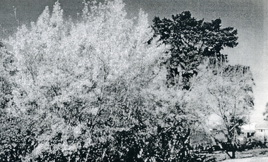
 Whitehorse Historical Society Inc.
Photograph, The Creek, c1960
Photographs relate to the Poultry Farms that existed in Nunawading and Forest Hill in the1950s and 1960s. Photos taken in 1961-62. Poultry farmers included Messrs Boyce, Gallos, Foote,Grimsley, Greenwood and Dudley|Slides scanned as a 'tiff' at 300dpi to CD Rom and cleaned and adjusted by Ted Arrowsmith.The Creek (near the island), cnr Canterbury and Mount Pleasant Roads. Mr Eckermann, in April 2002 said that the creek was very pretty and free running in the late 1940s and had blackfish in it.eckermann's, eckermann frank, poultry farms, nunawading, greenwood, forest hill, canterbury road, mount pleasant road nunawading, boyles, white, bruer's -
 Whitehorse Historical Society Inc.
Photograph, Mr. Greenwood's House, c1960
Photographs relate to the Poultry Farms that existed in Nunawading and Forest Hill in the1950s and 1960s. Photos taken in 1961-62. Poultry farmers included Messrs Boyce, Gallos, Foote,Grimsley, Greenwood and Dudley|Slides scanned as a 'tiff' at 300dpi to CD Rom and cleaned and adjusted by Ted Arrowsmith.Mr. Greenwood's house - Mrs Case sitting on verandah.eckermann's, eckermann frank, poultry farms, nunawading, greenwood, forest hill, canterbury road, mount pleasant road nunawading, boyles, white, bruer's -
 Whitehorse Historical Society Inc.
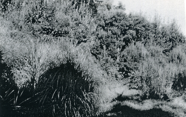
Photograph, Poplars along the creek, c1960
Photographs relate to the Poultry Farms that existed in Nunawading and Forest Hill in the1950s and 1960s. Photos taken in 1961-62. Poultry farmers included Messrs Boyce, Gallos, Foote,Grimsley, Greenwood and Dudley|Slides scanned as a 'tiff' at 300dpi to CD Rom and cleaned and adjusted by Ted Arrowsmith.Poplars along the creek as seen from Mr. Boyle's orchard.eckermann's, eckermann frank, poultry farms, nunawading, greenwood, forest hill, canterbury road, mount pleasant road nunawading, boyles, white, bruer's -
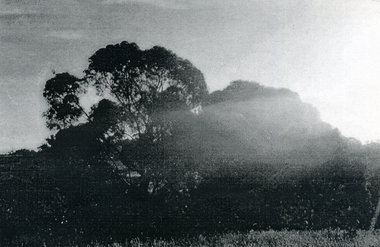 Whitehorse Historical Society Inc.
Photograph, View from Mr. Boyle's orchard, c1960
Photographs relate to the Poultry Farms that existed in Nunawading and Forest Hill in the1950s and 1960s. Photos taken in 1961-62. Poultry farmers included Messrs Boyce, Gallos, Foote,Grimsley, Greenwood and Dudley|Slides scanned as a 'tiff' at 300dpi to CD Rom and cleaned and adjusted by Ted Arrowsmith.Early morning sunrays on Boyle's gum trees - 6.30 am.eckermann's, eckermann frank, poultry farms, nunawading, greenwood, forest hill, canterbury road, mount pleasant road nunawading, boyles, white, bruer's -
 Whitehorse Historical Society Inc.
Photograph, Towards Mt Pleasant Road, c1960
Photographs relate to the Poultry Farms that existed in Nunawading and Forest Hill in the1950s and 1960s. Photos taken in 1961-62. Poultry farmers included Messrs Boyce, Gallos, Foote,Grimsley, Greenwood and Dudley|Slides scanned as a 'tiff' at 300dpi to CD Rom and cleaned and adjusted by Ted Arrowsmith.Looking towards Pleasant Road from Mr. Boyle's orchard.eckermann's, eckermann frank, poultry farm, nunawading, greenwood, forest hill, canterbury road, mount pleasant road nunawading, boyles, white, bruer's -
 Whitehorse Historical Society Inc.
Photograph, Looking to the Mountains, c1960
Photographs relate to the Poultry Farms that existed in Nunawading and Forest Hill in the1950s and 1960s. Photos taken in 1961-62. Poultry farmers included Messrs Boyce, Gallos, Foote,Grimsley, Greenwood and Dudley|Slides scanned as a 'tiff' at 300dpi to CD Rom and cleaned and adjusted by Ted Arrowsmith.Looking towards the mountains from behind Mrs. Bruer's.eckermann's, eckermann frank, poultry farm, nunawading, greenwood, forest hill, canterbury road, mount pleasant road nunawading, boyles, white, bruer's -
 Whitehorse Historical Society Inc.
Photograph, Mrs. White's House, c1960
Photographs relate to the Poultry Farms that existed in Nunawading and Forest Hill in the1950s and 1960s. Photos taken in 1961-62. Poultry farmers included Messrs Boyce, Gallos, Foote,Grimsley, Greenwood and Dudley|Slides scanned as a 'tiff' at 300dpi to CD Rom and cleaned and adjusted by Ted Arrowsmith.Mrs. White's House - 161 Mt Pleasant Road. Pulled down in 1960.eckermann's, eckermann frank, poultry farms, nunawading, greenwood, forest hill, canterbury road, mount pleasant road nunawading, boyles, white, bruer's -
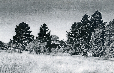
 Whitehorse Historical Society Inc.
Photograph, Houses in the big Orchard, c1960
Photographs relate to the Poultry Farms that existed in Nunawading and Forest Hill in the1950s and 1960s. Photos taken in 1961-62. Poultry farmers included Messrs Boyce, Gallos, Foote,Grimsley, Greenwood and Dudley.|Slides scanned as a 'tiff' at 300dpi to CD Rom and cleaned and adjusted by Ted Arrowsmith.The houses in the big orchard from Mr. Boyle's.eckermann's, eckermann frank, poultry farms, nunawading, greenwood, forest hill, canterbury road, mount pleasant road nunawading, boyles, white, bruer's -
 National Wool Museum
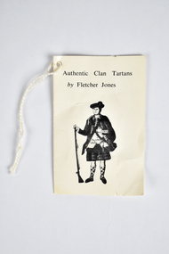
Card - Fletcher Jones Tag, Fletcher Jones, 1960s
This tag came with the donation of two kilts. The donor's mother, Joy Newall owned these kilts. She lived on a wheat/sheep farm in the Wimmera where her husband also bred merino sheep. Joy was well known in the district for the way she dressed when out in public.Four page fold out paper tag with black and white graphics and text. Graphic on the front and back shows a full length portrait of a person wearing traditional Scottish clothing resting with their hand holding an upright rifle. A piece of string is attached through a hole in the top left corner. Printed: Authentic Clan Tartans / by Fletcher Jonesclothing, fashion, tartan, kilt, scottish, wool -
 City of Kingston
Photograph - Black and white, 5 January 1984
Moorabbin, Cheltenham and Highett are suburbs in the City of Kingston with a diverse mix of development and zoning. The market gardens, farms and paddocks have gradually been sub-divided into housing and industrial estates and associated infrastructure such as schools and shopping facilities. The area includes many parks, reserves and golf courses.This aerial image covers a diverse section of the City of Kingston, taking in the suburbs of Cheltenham, Moorabbin, Beaumaris and Highett. By 1984, the market gardens of the district have been replaced by housing and factories. The Gas and Fuel state-of-the-art Scientific Services Department is visible on Nepean Highway Highett. The CSIRO Highett site can also be seen. Both sites have now been demolished and have undergone remediation. The Southland site is visible and yet to be redeveloped by Westfield. This image portrays the diversity of development in the City of Kingston with a mixture of green spaces, housing and commercial and industrial features.Aerial photograph of Cheltenham, Beaumaris, Moorabbin and Highett within the City of Kingston. The area depicted in the 1984 aerial view includes Eden Street and Edward Street, Cheltenham (top left), Weatherall Road and Reserve Road, Cheltenham/Beaumaris (top right), Turner Road and Chesterville Road, Moorabbin (bottom left), Nepean Highway (left section), Graham Road and Middleton Street, Highett (bottom right). A large section of this image includes Cheltenham Park and Victoria Golf Club.White text: 3831-219 Lens information [indecipherable] RINGWOOD M/S 7922-3 RUN 15 Clockface image 5,300' ASL VIC DLS© 5-1-84cheltenham, highett, industrialisation, urbanisation, moorabbin, beaumaris -
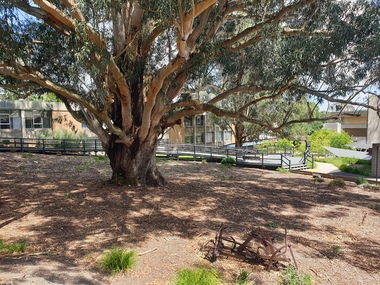 Federation University Historical Collection
Photograph - Photograph - Colour, The Tree of Knowledge, 2020, 26/02/2020
The 'Tree of Knowledge' was planted on Arbor Day 1896 by Mrs Elizabeth Downing who lived on the farm that was originally the Mount Helen Site. When the site was purchased in 1966 the architects and planners inspected the site and decided 'The Big Tree' must remain as a central landmark in preparing the layout of the campus.Photograph of the 'Tree of Knowledge', a Tasmanian Blue Gum (Eucalyptus glubulus labillo), located at the Mount Helen Campus of Federation University. The tree is registered by the National Trust,federation university, federation university australia, feduni, university of ballarat, mount helen, tree of knowledge, big tree, blue gum, mount helen campus -
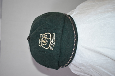 Warrnambool and District Historical Society Inc.
Hat, School W'bool High School, Early 1930s
This is a Warrnambool High School cap from the 1930s. Warrnambool High School was established in 1907 with a farm site in Merrivale and it was also in several sites in the main town area, with the longest occupancy in Hyland Street. In 1961 the school moved to its present location in Albert Park (Grafton Road). The High School amalgamated with Warrnambool North Technical School in 1995 to form Warrnambool College. Malcolm Goodall, the owner of the cap, was born in 1917 and died in 2010. He lived in Coulstock Street and he worked in the tinning department of Nestles. The Goodall family has been in the Warrnambool area since the mid 1850s including being at the farm, ‘Wanstead’ in East Warrnambool and at Framlingham in the 19th century where William Goodall was the manager of the aboriginal settlement. This cap is of interest as an example of the boys’ uniform at Warrnambool High School in the 1930s and as a memento of Malcolm Goodall. His ancestors were pioneers in the Warrnambool district.This is a boy’s cap made of dark green cloth with octagonal sections and a cloth button on top. The peak is edged with navy and cream cord. The centre front of the cap has a school badge with the school initials and motto. The inside of the cap is lined with black cloth with a cream centre and has the cap seller’s business details and the name of the owner of the cap. Some of the printed material here is indecipherable. The stitching is worn in some places. W.H.S. Sine Labore V. Becker Boys Shop & Hosiery Parlour Warrnambool Name: M. Goodall warrnambool high school, goodall family, history of warrnambool -
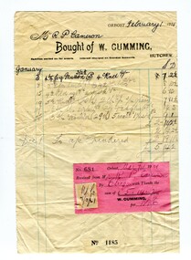 Orbost & District Historical Society
account, February 1st 1921
Robert Pullar Cameron was a Shire Councillor for many years. He married Penuel Hossack and had a family of James, Flora, Penuel and Alex. William Cumming was a prominent Orbost identity. He was born in Ballymena, Northern Ireland, in 1866 the son of William Cumming and Mary Ann Montgomery. He came to Australia, aged 28, and to Orbost in 1890. He farmed at Bete Bolong and during WW1 ran a butcher's shop on his farm. He was a shire councillor and served as a South Riding representative for 38 years. He was a keen Newmerella football supporter, a member of the Orbost Bowling Club as well as a director of the Orbost Butter Factory. Cumming was married to Ellen Louise Mundy and had four children ( Harold, Mary, William and Gordon).This item is an example of a hand-written account for a local early 20th century business in Orbost. It is a useful research tool.A white paper account with blue lines and black ink . It has a pink receipt attached as well as a yellow duty stamp. It is from W. Cumming, butcher, to R.P. Cameron.cameron-robert-pullar cumming-william-butcher -
 Wodonga & District Historical Society Inc
Functional object - Milk Can c. 1900s
North east Victoria was a major dairy producing region in the late nineteenth century. The first iteration of the Wodonga Butter Factory Ltd was established in 1892. Dairy was sent from farmers across the district for processing at the factory in Wodonga in the 1890s. Victorian creameries regularly exported frozen butter to London, stock was transported by rail for sale in Melbourne, and of course sold and consumed locally. E.W. Manns, of the prominent local Wodonga family, was a shareholder and was closely involved in the establishment of the Wodonga Butter Company. Many families living on farms also owned their own cow, and had equipment to process their own dairy products at home. Milk cans such as this one were used to store and transport milk from farms to dairies and butter factories for processing.This item represents the history of local industry in Wodonga and north east Victoria. A large metal milk can with handlesmilk, butter, cream, dairy, milk can, farming, farm, cow, rural, agriculture, wodonga -
 The Beechworth Burke Museum
Audio - Oral History, Jennifer Williams, Mrs Val Mason, 5 January 2001
Mrs. Valerie (Val) Mason (1927-2019) was a local sheep farmer, business-woman, Beechworth shire councillor, and mother to five children. With her husband, Charles, Mrs. Mason developed and managed the Big Valley farm estate, at Everton, which is now part of a vineyard and farm stay. Mrs. Mason was instrumental in introducing a 'paddock to plate' philosophy and business model, opening a butcher shop on the farm in 1973. Concerned with improving infrastructure and developing economic opportunities in the region, Mrs. Mason successfully stood as a local council representative for South Riding in the United Shire of Beechworth, and later become the first woman Shire President in 1979. Mrs Mason was a member of the local Business and Professional Women's Club for 37 years. This oral history recording was part of a project conducted by Jennifer Williams in the year 2000 to capture the everyday life and struggles in Beechworth during the twentieth century. This project involved recording seventy oral histories on cassette tapes of local Beechworth residents which were then published in a book titled: 'Listen to what they say: voices of twentieth century Beechworth. These cassette tapes were digitised in July 2021 with funds made available by the Friends of the Burke.Mrs. Mason's story is historically significant for understanding economic and social changes in the Beechworth region during the latter half of the twentieth century. As a council representative, issues such as road and infrastructure modernisation and the transition from traditional government employment sectors, like Beechworth's care institutions, were challenges for local government. As a farmer and local employer, Mrs. Mason's story is testimony to the region's economic diversification as businesses like Big Valley farm shop helped shape the region's contemporary character. Mrs. Mason was among the first women to broach the traditionally all-male Beechworth Council Chambers and her story is socially significant for understanding the changing role of women in rural and regional Australia. This oral history recording offers interpretive capacity for social history themes and may be compared with other oral histories in the Burke Museum's collection. This oral history account is socially and historically significant as it is a part of a broader collection of interviews conducted by Jennifer Williams which were published in the book 'Listen to what they say: voices of twentieth-century Beechworth.' While the township of Beechworth is known for its history as a gold rush town, these accounts provide a unique insight into the day-to-day life of the town's residents during the 20th century, many of which will have now been lost if they had not been preserved.This is a digital copy of a recording that was originally captured on a cassette tape. The cassette tape is black with a horizontal white strip and is currently stored in a clear flat plastic rectangular container. It holds up 40 minutes of recordings on each side.Mrs Val Mason /listen to what they say, beechworth, oral history, burke museum, working women, trail blazers, farm to plate, farm shop, paddock to plate, woman farmer, united shire of beechworth, rural and regional women, beechworth's first woman shire president, women in leadership positions, women leaders, australian settlement history, settler societies, victorian gold rush, heritage tourism, culinary tourism, regional land use, indigo winery, farm stay, social history -
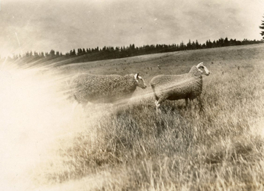 National Wool Museum
Photograph - Border Leicesters, J W Allen, 1928-1929
This photograph was found loose in the third of three albums compiled and owned by J W Allen, Secretary of New South Wales Grazier's, and is associated with the New South Wales Graziers Association world tour of sheep 1928-1929. The album contains photographs of travel, sheep, farms, stations, people and landscapes from around the world. Locations include Warren (NSW), Molong (NSW), Gamboola (NSW), Forbes (NSW), Hay (NSW), Conargo (NSW), Mokine (WA), New Zealand, Hawke's Bay, Southland, Lyttleton Harbour, Rotorua, Christchurch, Lincoln, Banks Peninsula, Akaroa, Pigeon Bay, Darfield, Rakahuri, Kaiwara, Highbank, Lake Heron, Mt Somers, Otago, Moa Flat, Waimahaka, Tarras, Moeraki and Blenheim. Properties depicted include Haddonrig, Egelabra, Bundemar, Redbank, Wandary, Tubbo Station, Coonong Station, Boonoke Station, Wanganella Estate, Yoorooga Estate, Taruna Farm, Harpenden Wool Works, Keppoch Estate, Bushey Park, Morven Downs, Meadowbank, Te Apiti and Penrose Farm. The album was found in a clean out at the Great Southern Agricultural Research Institute and donated to the National Wool Museum, along with other related material such as photographs, glass lantern slides and ephemera.Black and white image showing two sheep in a field.Back: [handwritten] Low, Highbank / Border ♀♀ / [printed] 68world tour, sheep, graziers, photograph, border leicester sheep -
 National Wool Museum
Album - Photo Album, 3 of 3, J W Allen, 1928-1929
This album is one of three albums compiled and owned by J W Allen, Secretary of New South Wales Grazier's, and is associated with the New South Wales Graziers Association world tour of sheep 1928-1929. This album contains photographs of travel, sheep, farms, stations, people and landscapes from around the world. Locations include Warren (NSW), Molong (NSW), Gamboola (NSW), Forbes (NSW), Hay (NSW), Conargo (NSW), Mokine (WA), New Zealand, Hawke's Bay, Southland, Lyttleton Harbour, Rotorua, Christchurch, Lincoln, Banks Peninsula, Akaroa, Pigeon Bay, Darfield, Rakahuri, Kaiwara, Highbank, Lake Heron, Mt Somers, Otago, Moa Flat, Waimahaka, Tarras, Moeraki and Blenheim. Properties depicted include Haddonrig, Egelabra, Bundemar, Redbank, Wandary, Tubbo Station, Coonong Station, Boonoke Station, Wanganella Estate, Yoorooga Estate, Taruna Farm, Harpenden Wool Works, Keppoch Estate, Bushey Park, Morven Downs, Meadowbank, Te Apiti and Penrose Farm. The album was found in a clean out at the Great Southern Agricultural Research Institute and donated to the National Wool Museum, along with other related material such as photographs, glass lantern slides and ephemera.Photo album with card cover and silk string binding. Inside are twenty four pages of brown carded paper with black and white photos and hand written black text. A white piece of paper with hand written text has been added to the inside front page.new south wales graziers association, world tour, sheep, farm, rural, agriculture, travel, new zealand, warren, molong, gamboola, forbes, hay, conargo, mokine, hawke's bay, southland, lyttleton, rotorua, christchurch, lincoln, banks peninsula, akoroa, pigeon bay, darfield, rakahuri, kaiwara, highbank, lake heron, mt somers, otago, moa flat, waimahaka, tarras, moeraki, blenheim, haddonrig, egelabra, bundemar, redbank, wandary, tubbo station, coonong station, boonoke station, wanganella estate, yoorooga estate, taruna farm, harpenden wool works, keppoch estate, bushey park, morven downs, meadowbank, te apiti, penrose farm -
 Greensborough Historical Society
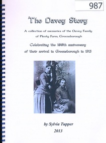
Book, The Davey Story; a collection of memories of the Davey Family of Plenty Farm, Greensborough; by Sylvia Tupper 2013, 1913-2013
This history of the Davey Family of Plenty Farm Greensborough was published to celebrate the 100th anniversary of John Henry Davey, his wife Elizabeth and children settling in Greensborough in 1913. The book contains stories written by many family members, photographs and traces the family line back to England in the 17th century.A thoroughly researched and referenced family history.108 pages, colour and black and white illustrations. Spiral binding. davey family, sylvia tupper, plenty farm, greensborough -
 Greensborough Historical Society
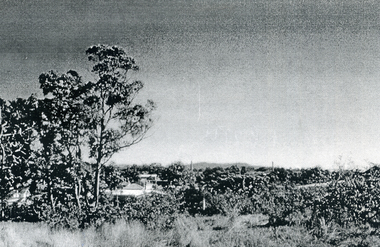
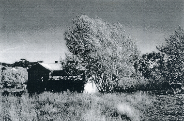
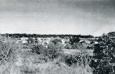
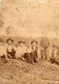
Photograph - Digital image, Onion Farm Greensborough, 1920c
Two photographs of the Onion Farm, Diamond Creek Road Greensborough. Photo 1 is not captioned; photo 2 (left to right) Harris the owner, unknown male, William Thomas Finn. Photographs from the collection of Peter Blackbourn, a descendant of the Chapman Stock family. Annotations to photos by Peter Blackbourn.Digital copy of two black and white photographs.peter blackbourn, william thomas finn, harris, onion farm greensborough