Showing 11171 items
matching map
-
 Queenscliffe Maritime Museum
Book - Royal Atlas 1861, Keith Johnston, The Royal Atlas of Modern Geography, 1861
Atlas of the word in 1861105 page leather bound atlas containing some coloured illustrations of maps of the countries of the world up to 1861. Published by William Blackwood & Sons, 1861. Folio [51x34cm] size with 9 pages of introductory text followed by 48 double-page spread and part coloured maps.non-fictionAtlas of the word in 1861geography, world atlas, keith johnstone -
 Falls Creek Historical Society
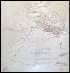
Map - Sun Valley, Falls Creek, 1966
This hand drawn map shows the Gully Chair, Summit Tow and the Village Tow. It also highlights the Nursery Poma. Several buildings can be seen along with the Visitor Centre in the Gully carpark, Skyline can can be seen adjacent to the Gully Chair. The Sun Valley T-Bar was designed by Ron McCallum and began operation in 1967. It had a length of 826 metres and an elevation of approximately 200 metres. In 1989 the Sun Valley T-Bar was replaced by the Scott Quad. Ron McCallum was a founder of Alpine Developments. It appears that his first lift was the Skyline portable tow at Falls Creek in 1954. As an engineer, he went on to build about 20 chairlifts and T-bars in the 1960s and early 1970s including at least five at Falls Creek. This map is significant because it shows plans for the development of a major tow at Falls Creek in the 1960s.A framed black and white concept map for the proposed new lift in Sun Valley, Falls Creek.sun valley tow, ron mccallum, falls creek tows -
 Bendigo Historical Society Inc.
Map - CAMPBELL COLLECTION: BENDIGO AND DISTRICT MAPS, 1982
Map. Forest Commission Victoria, Bendigo Forest District, Greater Bendigo Area. Shire of Marong, Sailors Gully, Epsom, Borough of Eaglehawk, Jackass Flat, White Hills, California Gully, Shire of Huntly, Maiden Gully, Long Gully, North Bendigo, Bendigo East, City of Bendigo, West Bendigo, Kennington, Shire of Strathfieldsaye, Flora Hill, Quarry Hill, Golden Square, Kangaroo Flat, Spring Gully. Prevention Strategy Plan. Base prepared 1982.map, bendigo, forest district -
Federation University Historical Collection
Book, City of Ballaarat Planning Scheme Review: Planning Policies Identification Summary Report, 1980, 02/1980
Brown soft covered book outlining the City of Ballarat Planning Scheme Review . Includes black and white images and a map.city of ballaarat, city of ballarat planning, planning scheme review, map -
 Melbourne Tram Museum
Document - Report, Parliamentary Public Works Committee, "Parliamentary Public Works Committee Report Plenty Road, Preston, Tramway Extension Enquiry, 1967
Report contained within a light brown card folder, containing a photocopy of report titled "Parliamentary Public Works Committee Report (including map) on The Plenty Road, Preston, Tramway Extension Enquiry - 1967". Report stapled in top right hand corner, 15 pages examining the extension of the East Preston route to Bolderwood Parade. Map shows extension proposed, bus routes, railway lines, streets - folded into 4.AETA stamp on front and inside sheet and "4E6" in ink on front cover. AETA stamp on the bottom right hand corner of the map.trams, tramways, east preston, new tramway, bolderwood parade, proposals -
 Federation University Historical Collection
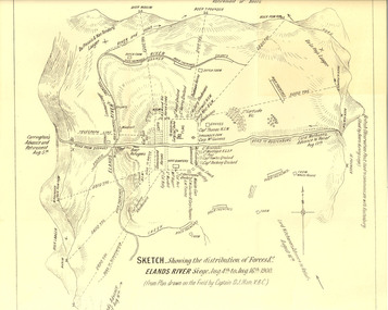
Plan, Sketch of Elands River Siege, 1900
Plan based on the field notes of Captain David John Ham, V.B.C. For article written by Ham on the event, see http://trove.nla.gov.au/ndp/del/article/9542500 For obituary of Ham, see http://trove.nla.gov.au/ndp/del/article/11023251Sketched paper map of forces' distribution at the Elands River siege. Map details surrounding hills, roads, rivers, and names all soldiers involved in siege. boer war, map, sketch, victorian's bushmen contingent, hocking, fowles, methuens, david john ham -
 Bendigo Military Museum
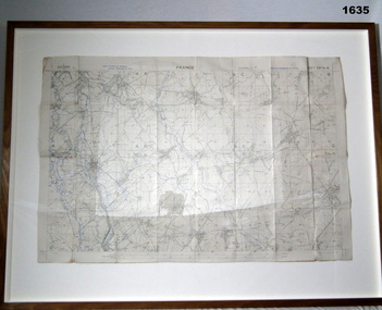
Accessory - MAP, TRENCH FRAMED
Belonged to JOHN WILLIAM GRINTON No 1043 C Coy 38th Batt AIF. Refer Reg No 1280 for Service Details also 1317P, 1319P. Refer 1634P for the story on the map.Trench map of France - Edition 5A Bellicourt - Montbrahain - Bran Court. Tan, wooden frame, glass front with white cardboard backing. Hanging wire attached at back with centre strengthening brace. Map stuck on white background. German trenches in blue. Top middle: France. RHS bottom rear: The Union Studio - Castlemaine sticker.documents - maps, frame accessories, military history - army -
 Eltham District Historical Society Inc
Book, A Review and Appraisal of the Diamond Creek to Ringwood Study, volume 2, working paper, by Loder and Bayly, 1979
Volume 2: Working papers. This report is a review and appraisal of the Outer Ring Road Study Diamond Creek to Ringwood prepared for The Road Planning Liaison Committee by the Joint Road Planning Group for the The City of Doncaster & Templestowe and The Shire of Eltham by Loder & Bayly Planning & Engineering Consultants. "This paper attempts to set a framework for an evaluation of the recommended road link between Diamond Creek and Ringwood." Various perspectives are examined. Includes fold out maps.91 p, maps, 27 cm.melbourne ring road, roads, freeways -
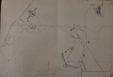
 Ringwood and District Historical Society
Map, Plan of Country Lands in the Parishes of Nunawading Ringwood and Scoresby - circa 1855
Blueprint copy of Survey Map detailing original Selectors' names and property locations. List of Parish map references including property bearings, distances in Links, and markings on trees. Descriptive remarks include areas marked "Farmer's Common", "Poor soil thickly/moderately timbered with stringy bark", and location of water and firewood reserves."Surveyed and plotted by N.M. Bickford, Superintendant of Mr. Hodgkinson's Field Party". "The land comprised in this survey is of inferior quality, moderately undulating, and thickly wooded. It is watered by Dandenong Creek and Deep Creek." Inset map showing location of (*proposed) cemetery on southern corner of Lillydale Road from Melbourne and Sawmill Road, later Mount Dandenong Road. (*Cemetery did not eventuate.) -
 Whitehorse Historical Society Inc.
Document, Orcharding and the Blue moon Cooperative
Typescript history of the Blue Moon Cooperative LtdTypescript history of the Blue Moon Cooperative Ltd also a map indicating the destinations to which fresh fruit was shipped by the Blue Moon Group of companies.Typescript history of the Blue Moon Cooperative Ltdcool stores, blue moon fruit co-operative ltd -
 Bendigo Historical Society Inc.
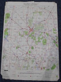
Map - Bush Fire Control Map Bendigo District
A Bush Fire Control map is a valuable tool used by emergency services and communities to respond to respond to bushfires.Cream coloured parchment map showing roads, railway lines, telephone lines, rivers, creeks and water courses. Also marked are houses, Post Offices, Police stations, bush fire brigades, water channels, swamps, marshes, dense, medium and scattered timber, aqueducts and reservoirs. Villages, districts and Towns are clearly marked. Printed in red, green, black and blue. Very clear and easy to read. Undated.bush fires, bendigo area map -
 City of Kingston
Map - Parish of Moorabbin
Warning: This object includes historical language referring to First Nations Peoples which is no longer appropriate but has been recorded for historical purposes. Produced in 1853, this map shows the land holdings of European families. While the majority of holdings are small there are also large land holdings as can be seen with Henry Dendy's Special Survey. Of particular note is the "Reserve for Aborigines" which was established in approximately 1841 and consisted of over 830 acres. This area is the current location of Mordialloc township and Attenborough Park, in Mordialloc, is the last remnant of the reserve. An Alfred Sikes, possibly the surveyor/cartographer who drew this parish plan, purchased land in Berwick in 1854.A handrawn map on fabric, with blue markings representing the coastline to Port Phillip Bay, red markings representing a proposed train line to Mordialloc, major roads and street, as well as a "Reserve for Aborigines", which constituted approximately 830 acres. In the bottom right hand corner, the map has been signed and dated.Handwritten in ink: Alfred Sikes / 38 Collins St East / June. 1853moorabbin, mordialloc, dendy, port phillip bay, aboriginal reserve, attenborough park -
Kew Historical Society Inc
Book, Geoffrey Blainey, A History of Camberwell, 1980
104p., [20]p. of plates : ill., map, ports. ; 22cm.non-fictioncamberwell (vic.) -- history, victoria -- camberwell. -
Kew Historical Society Inc
Book, Geoffrey Blainey, A History of Camberwell, 1964
104p., [20]p. of plates : ill., map, ports. ; 22cm.non-fictioncamberwell (vic.) -- history, victoria -- camberwell. -
Kew Historical Society Inc
Book, Dorothy Rogers, A History of Kew, 1973
xvi,256p. : maps on lining papers, plates, tables ; 24cm. non-fictionkew (vic.) -- history., melbourne -- kew 1840-1972 -
Kew Historical Society Inc
Book, Dorothy Rogers, A History of Kew, 1973
xvi ,256p. : maps on lining papers, plates, tables ; 24cm. non-fictionkew (vic.) -- history., melbourne -- kew 1840-1972 -
Kew Historical Society Inc
Book, Powerline Review Panel, Final Report to the Victorian Government, 1989
Final Report to the Victorian Government of the Powerline Review, 1989264 p. in various pagings : ill., maps ; 30 cm.non-fictionFinal Report to the Victorian Government of the Powerline Review, 1989electric power distribution -- victoria -- brunswick, electric power distribution -- victoria -- richmond -
 Greensborough Historical Society
Maps, Mont Park, Gresswell, Larundel, 01/08/1949
Map of Mont Park area, including Larundel, Gresswell and Kingsbury Farm, between Plenty Road and Waiora Road, as at 1949, including buildings. Map of Mont Park area, including Larundel, Gresswell and Kingsbury Farm. Ink & pencil. Scale: 200': 1 inch49/147, R. G. H.mont park, larundel, gresswell watsonia, kingsbury -
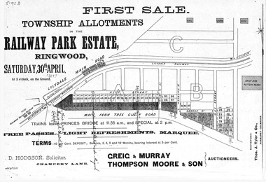 Ringwood and District Historical Society
Flyer, Subdivision advertisement - Railway Park Estate, Ringwood, Victoria - circa 1887
Photocopy of advertisement for auction sale of township allotments in Railway Park Estate, Ringwood, on Saturday 30th April (1887?), with terms of sale and location map.Subdivision map includes Pitt Street and Main Ferntree Gully Road (later Bedford Road). (Agents) Greig & Murray, Thompson Moore & Son, Auctioneers. -
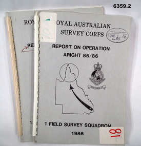 Bendigo Military Museum
Administrative record - Royal Australian Survey Corps Report on Operation Aright 85 / 86 1 Field Survey Squadron 1986, 1986
Operation ARIGHT 85 was mounted by 1 Fd Svy Sqn 14 May to 8 Aug 1985 and 1 May to 15 May 1986. In the 1:250,000 SG54-15 Rutland Plains map area. In addition 18 X 1:50 000 maps were field completed.6359.1 Copy 1. 6359.2 Copy 2. A4 Cardboard cover, grey, plastic ring binder, report, diagrams, maps, plastic ring binder.royal australian survey corps, 1 field survey squadron, 1fd svy sqn, rasvy, fortuna, army survey regiment, army svy regt, asr -
 Eltham District Historical Society Inc
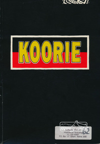
Book, Koorie Heritage Trust, Koorie, 1991c
Oldest culture - Yarra River and Port Phillip - Religion - Serpents - Fire - In 1830 - First contacts - Massacre map - Survival - Identity - Resistance and rights (Pastor Sir Douglas Nicholls) - Land rights - From hand-out to hand-back - Aborigines in war - Sportspeople - Cultural heritage.Paperback; 57, [3] pages : illustrations, maps, ports ; 30 cm.ISBN 0724198105aborigines, social customs, koorie, victoria -
 Eltham District Historical Society Inc
Folder, Victorian Goldfields Project: Historic gold mining sites in St Andrews mining division, 1999
Heritage site report and gazetteer by David Bannear, head consultant for archealogy for the Department of Natural Resources and Environment. Includes information on the Warrandyte Goldfield and the Caledonia Goldfield, Queenstown (now known as St Andrews), One Tree Hill, Kingston (now known as Panton Hill), Kangaroo Grounds, You You Hill, Kingstown, South Morang, Nillumbik, (now known as Diamond Creek), Steele's Creek, Yarrambet and Kinglake. Photocopy of map headed: Location of mines and reefs from Geological survey of Victoria, Yan Yean with the Diamond Creek prominant on the map. no date35 page report with map and print out of cover letter (email form) from donorcaledonian gold fields, caledonina gold field, david bannear, gold mining, harry gilham collection, queenstown, st andrews, warrandyte goldfield -
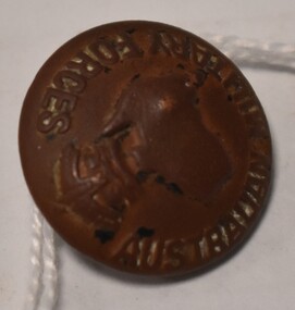 Tatura Irrigation & Wartime Camps Museum
Button - brass, P J King Pty Ltd, 1940's
Found at POW camp 13 site post war by war time camp guardBrass button with Australian Military Forces around front edge, map of Australia in centre with a crown above. Has a brass loop on the back to attach to clothing. Contained in a black material covered display case with gold around edge.on front: Australian Military Forces and a map of Australia and crown. on back P J King Pty Ltd Melbbrass buttons, camp 13, military uniform accessories -
 Ringwood and District Historical Society
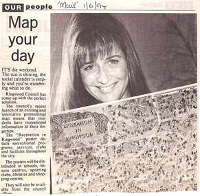
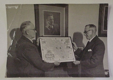
Newspaper, Scrapbook Clipping, Library Collection, Ringwood, Victoria, `
``Newspaper clipping from "The Mail" 1-6-94 OUR people Map your dayThe Ringwood Council's recent launch of an exciting and innovative promotional map means that residents have recreational information at their fingertips. The "Recreation in Ringwood"poster details recreational pograms, services, clubs and facilities throughout the city` -
 National Wool Museum
Photograph
Photograph of Lewis Hirst and Mr Gliddon, holding a framed map of Yorkshire. They are standing in front of a photographic portrait of Godfrey Hirst c1950.Photograph of Lewis Hirst and Mr Gliddon, holding a framed map of Yorkshire. They are standing in front of a photographic portrait of Godfrey Hirst c1950.Godfrey Hirst/ Lewis Hirst/ Mr Gliddon- Foremanweaving mills, godfrey hirst and co. pty ltd excelsior woollen and worsted mills, hirst, mr godfrey hirst, mr lewis -
Whitehorse Historical Society Inc.
Pamphlet, Bellbird Dell
A pamphlet about a municipal reserve - Bellbird Dell, with a list of names of the Management Committee.A pamphlet about a municipal reserve - Bellbird Dell, with a list of names of the Management Committee. Also states they are looking for helpers for regular working bees. Includes map of reserve.A pamphlet about a municipal reserve - Bellbird Dell, with a list of names of the Management Committee.local government, city of nunawading, bellbird dell, vermont -
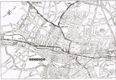 Bendigo Historical Society Inc.
Map - MAP OF CENTRAL BENDIGO
Map of Central Bendigo, RACV Copyright (no date - but RACV Branch Office is shown as being at View Point). Black & White Copy. Showing road and rail system and prominent features of City landscape.RACV Copyright.map, bendigo, city streets, long gully, north bendigo, golden sqyare, specimen hill, iron bark. -
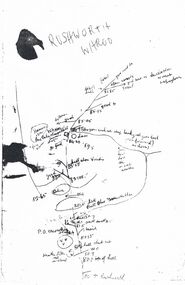 Bendigo Historical Society Inc.
Map - PETER ELLIS COLLECTION: MAP
Five photocopies of drawings of the Rushworth area and three copies of Rushworth-Whroo. All maps have various features and some plants noted. Also mentioned is the Balaclava Hill Open Cut Mine.map, victoria, rushworth/whroo, peter ellis collection, rushworth, whroo, aboriginal water holes, balaclava hill open cut mine -
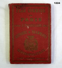 Bendigo Military Museum
Plan - MAP, TOURIST, L Joly, A Maunier, WWI
The map belonged to Jack Grinton No 1043 38th Batt AIF. At Wars end extensive leave was granted, Jack journeyed to Paris, Nice, Monte Carlo taking many photos. Part of the Grinton collection which included hundreds of negatives and developed photos that he took during the War. Refer Cat No 1280 for service details. Refer 1317P, 1320P.Map of Paris. Red cardboard or paper hardcover, new edition guide of metropolitan Paris (ministries, tramways, monuments), Index in front, folded paper map attached to back cover. "Plan commode de Paris avec l'itineraire des autobus & tramways metropolitan"documents-maps, french -
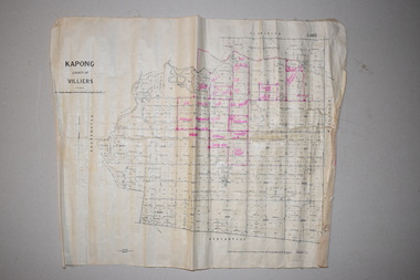 Warrnambool and District Historical Society Inc.
Maps (2), 1 Kapong .2 Hawkesdale, 1 1913 .2 1942
These two maps of the Kapong/ Hawkesdale area in Victoria show the original lands that belonged to the pioneer settler, Charles Hamilton MacKnight and the handwritten annotations that show the subsequent owners of these lands. Charles Hamilton Macknight (1819-1873) came to Australia from Scotland in 1841 and in 1842, with partners, James Irvine and William Campbell, established the property of Dunmore in Broadwater (24 kilometres from Hawkesdale). He was a prominent breeder of sheep, cattle and horses. Sections of his lands were acquired by the Baulch family and these maps were acquired from a member of the Baulch family, with Stanley Baulch being the possible annotator of the Kapong map. These maps are of interest as they show the properties that belonged to the pioneer settler, Charles Hamilton MacKnight and the subsequent division of these lands, some of these passing into the hands of the Baulch family. As the Kapong map also shows other original landowners, it will be a useful tool for researchers..1 This is a map of Kapong in the County of Villiers. It is on a rectangular-shaped piece of linen-backed paper with black printing and some handwritten annotations in red ink. It is crumpled at the edges. .2 This is a rectangular-shaped piece of paper showing a map of the Hawkesdale area. The printed material is in grid form in black, green and red. At the left bottom edge it has a mauve stamp. kapong, victoria, hawkesdale, victoria, dunmore estate, victoria, charles hamilton macknight, baulch family, western victoria, history of warrnambool