Showing 10388 items
matching plan
-
 Lakes Entrance Regional Historical Society (operating as Lakes Entrance History Centre & Museum)
Book, Department of Conservation and Environment, Wilderness Special Investigation Final Recommendations, 1991
An approved management plan relating to the public foreshore land between Lake Bunga and Mill Point. Contains plans and appendices.waterfront, vegetation -
Whitehorse Historical Society Inc.
Legal record - Illustration, Display Centre
Architect's outline plans of Display Centre for Schwerkolt Cottage. IArchitect's outline plans of Display Centre for Schwerkolt Cottage. Includes elevations and plan. Differs in detail from final building.Architect's outline plans of Display Centre for Schwerkolt Cottage. Ischwerkolt cottage & museum complex, architect plans -
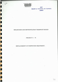 Melbourne Tram Museum
Document - Report, Melbourne & Metropolitan Tramways Board (MMTB), Project 3-75 - Replacement of Substation Equipment", 1975
Digital copy of a 9 page report by the MMTB, titled Project 3-75 - Replacement of Substation Equipment", proposing to replace the rotary converters installed between 1924 and 1930 with silicon rectifiers. Gives the locations, costs, schedule of replacement commencing 1975, in particular South Melbourne, Malvern and Young St Fitzroy. Gives a background to the system, a list of all the substations at the time, including date of installation, type, replacement of HV equipment, costs, reliability, maintenance costs, and benefit to cost ratio.Has the stamp of "Joint Ministry of transport and Tramways Library" and a "Plan & EPA Library barcode"trams, tramways, substation, transformer, power supply, electrical engineering, rotary converters -
 Kew Historical Society Inc
Photograph - Cottage, probably East Kew, A. Aberline, 1920s
The Kew Historical Society's map collection includes a substantial number of real estate subdivision plans, mainly of Kew but also of surrounding suburbs in Melbourne. Most of the subdivision plans date from the 1920s and 1930s when the districts old homes and local farmland were being split up to accommodate residential growth in the postwar period. These early plans were assembled by a local firm, Jas R Mather & McMillan, which had an office in Cotham Road. Many of the plans, and sometimes photos, were annotated by the agents.Subdivision plans are historically important documents used as evidence for the growth of suburbs in Australia. They frequently provide information about when the land was sold as well as evidence relating to surveyors and real estate and financial agents. The numerous subdivision plans in the Kew Historical Society's collection represent working documents, ranging from the initial sketches made in planning a subdivision to printed plans on which auctioneers or agents listed the prices for which individual lots were sold. In a number of cases, the reverse of a subdivision plan in the collection includes a photograph of a house that was also for sale by the agent. These photographs provide significant heritage information relating house design and decoration, fencing and household gardens.The photograph may also be aesthetically significant depending on the importance of the photographic atelier.An elevated, modest weatherboard house, photographed towards the end of the construction phase. The lower section of the weatherboards are exposed and stained. The upper section is rendered with rough-cast. The tiled roof has a single gable that extends over the centrally placed front porch. On the porch, the door and single sidelight are filled with coloured leadlight whereas the casement windows in the front rooms contain plain glass. The leadlight and the wrought iron of the verandah are the only decorative elements of the utilitarian design. The location of the house, which was advertised for sale, has not to date been identified. The real estate photograph is mounted on the reverse of a subdivision plan for the Harvest Home Estate, Kew East.Photographer's stamp, lower right on mount: "A. Aberline, Glenferrie"houses - kew, bungalows - kew, real estate photographs -
 Kew Historical Society Inc
Photograph - Bungalow, probably East Kew, 1920s
The Kew Historical Society's map collection includes a substantial number of real estate subdivision plans, mainly of Kew but also of surrounding suburbs in Melbourne. Most of the subdivision plans date from the 1920s and 1930s when the districts old homes and local farmland were being split up to accommodate residential growth in the postwar period. These early plans were assembled by a local firm, Jas R Mather & McMillan, which had an office in Cotham Road. Many of the plans, and sometimes photos, were annotated by the agents.Subdivision plans are historically important documents used as evidence for the growth of suburbs in Australia. They frequently provide information about when the land was sold as well as evidence relating to surveyors and real estate and financial agents. The numerous subdivision plans in the Kew Historical Society's collection represent working documents, ranging from the initial sketches made in planning a subdivision to printed plans on which auctioneers or agents listed the prices for which individual lots were sold. In a number of cases, the reverse of a subdivision plan in the collection includes a photograph of a house that was also for sale by the agent. These photographs provide significant heritage information relating house design and decoration, fencing and household gardens.The photograph may also be aesthetically significant depending on the importance of the photographic atelier.An unusual bungalow that does not conform to a particular architectural style but which contains eclectic elements of the style of varying periods. The most striking element of the design is the cantilevered veranda that is supported by heavy chains that are attached to the central gable. This deep gable extends across most of the façade, forming an extensive veranda. Parts of this are infilled with screens. Seven wooden posts, whose lower halves are encased in rendered brick pillars, support this gabled veranda. The roof would appear to be covered with corrugated iron. The location of the house, which was advertised for sale, has to date not been identified. The real estate photo is on the reverse of a plan for the Myrtle Hill Subdivision, Kew.bungalows - kew, architecture - 1920s, real estate photographs -
Port Melbourne Historical & Preservation Society
Plan - Proposed docks and straight cut canal, Port Melbourne, Proposed Harbour Accommodation, 23 Sep 1902
Large plan of proposed docks and straight cut canal, reserve, proposed Harbour Accommodation - Port Melbourne. (Brown with age/or dirt) Shows enormous landfill into Hobson's Bay and around Town and Railway Piers; branch railway lines. Includes dredging plans and two narrow docks at Melbourne - also garden reserve and suburb of Fishermen's Bend.melbourne harbor trust - port of melbourne authority, town planning - proposals shelved, fishermans bend -
Bendigo Historical Society Inc.
Plan - MARKS COLLECTION: UNDERGROUND SURVEY MR. DENNIS CLAIM NEW CHUM
Plan on heavy parchment. On top of plan 'underground survey Mr. Dennis, New Chum' Signed: Thomas Forbes, Surveyor, 11th. January 1867. shows surface boundary of Dennis and Bonati. Written in blue pencil 'From nail in sapling 33f. 51/2 to boundary. On line to drill hole' Shaft marked on LH boundary.bendigo, mining, mr. dennis claim, new chum -
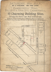 Kew Historical Society Inc
Plan - Subdivision Plan, 10 Charming Building Sites, 1930-1940
This subdivision plan shows 10 lots, numbered A-J, that were offered for sale in Camberwell. Streets in the subdivision include Camberwell Road, Judd Street, Bellett Street and King Street. The plan lists existing houses in the vicinity including weatherboard and ‘Rough Cast’ villas. The old Golf Links are identified at the rear of the Bellett Street lots.subdivision plans -- camberwell (vic.) -
University of Melbourne, Burnley Campus Archives
Plan - Plans, Alterations and refurbishment of the Centennial Display Building
-
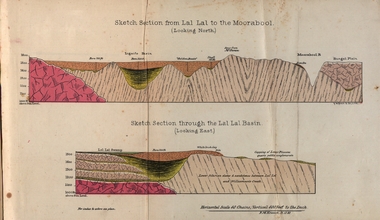 Federation University Historical Collection
Booklet, Luplau, Hewood & Riderm Printers, The School of Mines Ballaarat Annual Report 1883, 1883
The School of Mines Ballaarat. Annual Report 1883. Statement of Receipts and expenditure, general balance sheet, and list of subscriptions donations 1882. Sketch of School of Mines. Sketch Section from Lal Lal to the Moorabool (looking north) Geological map of Lal Lal. In the County of Grant. Annual Report, Balance Sheet, Certificates granted by the Council, Examination Papers - Elementary Science Classes (Appendix), Extracts from Visitors' Book, Fees, Form of Bequest, Honorary Correspondents. Life Governors, Museum - open to visitors, Notes on the Geology of Lal Lal (with Geological Plan & Sections), Obituary, Office Bearers, Paper of Particulars, Rules of the Ballaarat Field Club and Science Society (Appendix), Report of the Curator of the Museum and Library, Report of the Superintendent of Laboratories, Report of the Lecturer in Mathematics, Report of the Lecturer in Mechanical Engineering, Report of the Lecturer in Telegraphy, Report of the Lecturer in Materia Medica, Statement of Receipts and Expenditure for the year 1882, Subjects and Lectures, Subjects and Examiners, Subscriptions and Donations, from 1st January to 31st December 1882.Ballaarat School of Mines annual Report. Hard cover red book of 101 pages. Includes plans on Lal Lal and surrounds. ballarat school of mines, annual report, balance sheet, certificates granted by the council, examination papers, extracts from the visitors' book, fees, form of bequest, honorary correspondents, life governors, museum, notes on the geology of lal lal, obituary: charles william thomas. one of the examiners in mining and surveying, office bearers, paper of particulars, rules of the ballaarat field club and science society, report of the curator of the museum and library, report of the superintendent of laboratories, report of the lecturer in mathematics, report of the lecturer in mechanical engineering, report of the lecturer in telegraphy, report of the lecturer in materia medica, statement of receipts and expenditure for the year 1882, subjects and lectures, subjects and examiners, subcriptions and donations, from 1st january to 31st december 1882, alf. mica smith, professor of chemistry, alf. mica smith, metallurgy, f. m. krause - professor of geology, mineralogy, scientific mining, t. h. thompson, practical mining, w. h. shaw mechanical engineering, h. reid, mechanical enginnering, phoenix foundry company (limited), a. a. buley, mathematics, f. m. krause, land, mining and engineering surveying, w. d. campbell, telegraphy, james oddie, vice-president, alf. mica smith, natural philosophy (elementary mechanics and hydrostatics, magnetism and electricty, sound, light and heat), j. f. usher, materia medica, pharmacy and physiology, examiner, professor h. m. andrew, m. a., examiner, h. d. de la poer wall, m. a, c. e., examiner, thomas mann, b. a., examiner, p. c. fitzpatrick, c. s., examiner, h. rosale, j.p., f.g.s, m.e. and m, examiner, john lewis, examiner, w. c. kernot, m.a., c.e., examiner, professor mccoy, examiner, j. cosmo newbery, c.m.g., b. sc., examiner, baron von mueller, k.c.m.g., m. et ph. d., f. r.s., examiner, sam. w. macgowan, examiner, w. p. bechervaise, examiner, r. l. j. ellery, f.r.s. govt. astronomer, examiner, f. m. krause, c.e., examiner, j. m. bickett, examiner, n. kent, examiner, a. martin, examiner, r. s. mitchell, examiner, w. h. keast, examiner, p. matthews, examiner, d. milliken, examiner, j. t. richards, examiner, jonathan robinson, examiner, t. h. thompson, examiner, h. brookes allen, m.d., examiner, joseph bosisto, examiner, c. r. blackett, m.l.a., examiner, wm. johnson, analyst to the government of victoria, ferdinand krause, ballarat field naturalists club, ferdinand von mueller, thomas mann, a.a. buley, ferrdinand krause, alfred mica smith, james oddie, william johnson, jonathan robinson, james bickett, r.l.j. ellery, cosmo newbery, ballarat field naturalists -
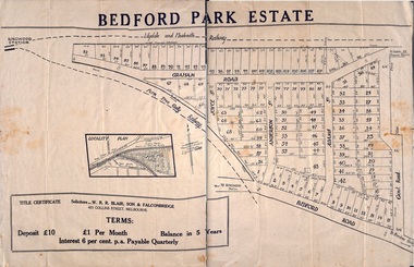 Ringwood and District Historical Society
Plan - Sub-division, Bedford Park Estate, Ringwood, Victoria - 1924
Bedford Park subdivisional development did not eventuate. The land adjoining the railway line became parkland with provision for sporting facilities and the remainder was purchased by the Education Department as the site for Ringwood High School/Secondary College. Poster size land sale advertisement.Subdivision plan includes Bedford Road, Graham Road, Joyce Street, Anderson Street, and Adams Street. Solicitors - W.R.R. Blair, Son & Falconbridge, 405 Collins Street, Melbourne. -
 Kew Historical Society Inc
Map - Subdivision Plan, Grenville Estate, 1922
Pru Sanderson, in her groundbreaking ‘City of Kew Urban Conservation Study : Volume 2 - Development History’ (1988), summarised the periods of urban development and subdivisions of land in Kew. The periods that she identified included 1845-1880, 1880-1893, 1893-1921, 1921-1933, 1933-1943, and Post-War Development. These periods were selected as they represented periods of rapid growth or decline in urban development. An obvious starting point for Sanderson’s groupings involved population growth and the associated economic cycles. These cycles also highlighted urban expansion onto land that was predominantly rural, although in other cases it represented the decline and breakup of large estates. A number of the plans in the Kew Historical Society’s collection can also be found in other collections, such as those of the State Library of Victoria and the Boroondara Library Service. A number are however unique to the collection.Subdivision plans are historically important documents used as evidence of the growth of suburbs in Australia. They frequently provide information about when the land was sold on which a built structure was subsequently constructed as well as evidence relating to surveyors and real estate and financial agents. The numerous subdivision plans in the Kew Historical Society's collection represent working documents, ranging from the initial sketches made in planning a subdivision to printed plans on which auctioneers or agents listed the prices for which individual lots were sold. In a number of cases, the reverse of a subdivision plan in the collection includes a photograph of a house that was also for sale by the agent. These photographs provide significant heritage information relating house design and decoration, fencing and household gardens.In advertising the twenty-two sites of the Grenville Estate in Cotham Road and Alfred Street, Kew, the auctioneers emphasised the proximity of the development to shops, schools, and churches. That mansions surrounded the Estate was publicised as an added attraction. The plan shows how at this stage A regrettable aspect of this plan is that it is pasted over, and obscures a real estate photograph by the Kew photographer Josiah Earl Barnes.subdivision plans - kew, grenville estate, glenferrie road, alfred street, thomas street, cotham road -
Federation University Historical Collection
Booklet, Ballarat School of Mines Planning Paper, 1977, 1977
Ballarat School of Mines is a predecessor institution of Federation University Australia.Two planning papers for the School of Mines and Industries, Ballarat. .1) Planning Paper 1977/4, June 1977 by Graham H. Beanland, Principal. Includes developmental planning, educational philosophy, campus and accomodation, residential accomodation needs. .2) Planning Paper 1977/5, August1977 by Graham H. Beanland, Principal. Includes developmental planning, educational philosophy, campus and accomodation, residential accomodation needs.ballarat school of mines, smb campus, tafe, planning paper, graham beanland, campus plan, ballarat school of mines campus -
Federation University Historical Collection
Booklet, Ballarat School of Mines Planning Paper, 1978, 1978
Ballarat School of Mines is a predecessor institution of Federation University Australia.Two planning papers for the School of Mines and Industries, Ballarat. .1) Planning Paper 1978/7, June 1978. Includes linkage of Art and Chemistry buildings and the developmeny of sporting and recreational community project. Includes plan of the old Chemistry Building .2) Planning Paper 1978/8, June 1978. Includes SMB situation, educational philosophy, campus and accomodation, campus plan diagrams, student unionballarat school of mines, smb campus, tafe, planning paper, ballarat technical art school, old chemistry building, building linkage, overpass, white flat oval, ballarat youth centre, corbould hall, fire escape, motor mechanics, corbould hall, rural studies, campus plan, ballarat school of mines campus -
 Kew Historical Society Inc
Plan - Subdivision Plan, Jaques Estate, 1927
The Kew Historical Society collection includes almost 100 subdivision plans pertaining to suburbs of the City of Melbourne. Most of these are of Kew, Kew East or Studley Park, although a smaller number are plans of Camberwell, Deepdene, Balwyn and Hawthorn. It is believed that the majority of the plans were gifted to the Society by persons connected with the real estate firm - J. R. Mathers and McMillan, 136 Cotham Road, Kew. The Plans in the collection are rarely in pristine form, being working plans on which the agent would write notes and record lots sold and the prices of these. The subdivision plans are historically significant examples of the growth of urban Melbourne from the beginning of the 20th Century up until the 1980s. A number of the plans are double-sided and often include a photograph on the reverse. A number of the latter are by noted photographers such as J.E. Barnes.The Jaques Estate was a small subdivision of eight residential allotments bordering Jaques Street and Barkers Road in what is now Hawthorn East. Advertised in The Argus as being in ‘Upper Hawthorn’ the subdivision was claimed to include: ‘charming villa sites in excellent situations, with every convenience available, and with superior homes surrounding’.subdivision plans - hawthorn, jaques estate -
Glenelg Shire Council Cultural Collection
Plan - Plan - subdivision at Cape Bridgewater, n.d
Black and white photocopy of a 1990s plan of a subdivision at Cape Bridgewater - 'Heritage Valley'. Twenty-eight lots . In two halves, not joined togethertown planning, residential, sub divide, cape bridgewater -
Port Melbourne Historical & Preservation Society
Plan - Proposed Alterations, Port Melbourne Town Hall, B S Elms & Co Pty Ltd, 23 Jun 1966
From a set of two drawings, 1966 - plans - details of alterations to Council Chamber, Councillors Room and first floor of Town Hall - not proceeded with. port melbourne town hall -
Port Melbourne Historical & Preservation Society
Plan - Port Melbourne, 1882
Large, deteriorated 1882 plan of Port Melbourne, Parish of South Melbourne, County of Bourke - showing Town Lots. Pasted onto board.town planning, fishermans bend, sandridge lagoon, transport - railways -
Port Melbourne Historical & Preservation Society
Plan - Tramway, Normanby Road, Ingles Street to Boundary Street, Port Melbourne, 14 Mar 1893
Plan of tramway in Normanby Road from Ingles Street to Boundary Street, together with written specification for works attached (Reg 66.2), 1893.A.V. Heath (Town Surveyor) J.J. Bartlett (Mayor)engineering - roads streets lanes and footpaths, transport - tramways, town planning, town clerks, mayors, arthur victor heath, james john bartlett -
Port Melbourne Historical & Preservation Society
Plan - Main drain, west branch, Evans Street to Esplanade East, Port Melbourne, 14 Mar 1893
Plan of main drain west branch, from Evans Street to Esplanade East (together with written specifications attached - refer 75.1) 1893.J.J. Bartlett (Mayor) 14/3/93engineering - canals and drainage, arthur victor heath, town clerks, james john bartlett, mayors -
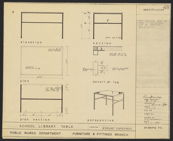 University of Melbourne, Burnley Campus Archives
Plan, N.S. Jemmerson, Specification for School Library Table, 1961
Plan. A. No. 47 B. No. 48 for Chief Architect, Ray Davey, Public Works Dept., Furniture & Fittings Branch. Drawn by N.S. Jemmeson.ray davey, n.s. jemmerson -
 University of Melbourne, Burnley Campus Archives
Plan, Border Next to Staff Car Park, c. 1980
(1) Rough hand drawn plan in pencil and biro of area between Pergola and roadway to Library opposite Roundabout Lawn. (2) Photocopy.pergola, library -
University of Melbourne, Burnley Campus Archives
Plan, City of Keilor, Delahey Recreational Reserve, Tennis Complex, Goldsmith Ave, 1994
(1) Planting Plan, coloured, dated 19.08.1994, Sheet 3 of 3. by J.Coghill. Scale 1:100. (2) Sheet 2 of 3.keilor, delahey recreational reserve, , j. coghill, planting plan -
Port Melbourne Historical & Preservation Society
Plan - Handcoloured location of Libbis family members' homes on copy of a section of 1894 MMBW map, 1894
Obtained from MMBW by Peter LIBBIS when researching Libbis family historyPhotocopy of a section of 1894 MMBW plan 118 which have been handcoloured to indicate locations such as homes of various Libbis family membershandcoloured to indicate locations such as homes of various Libbis family membersbuilt environment, families, peter libbis -
Port Melbourne Historical & Preservation Society
Plan - Handcoloured location of Libbis family members' homes on copy of a section of 1894 MMBW map, 1894
Obtained from MMBW by Peter LIBBIS when researching Libbis family historyPhotocopy of a section of 1894 MMBW plan 118 which has been handcoloured to indicate locations such as homes of various Libbis family membershandcoloured to indicate locations such as homes of various Libbis family membersbuilt environment, families, peter libbis -
 University of Melbourne, Burnley Campus Archives
Plan, Proposed Layout Groundcover Evaluation/Demonstration Plots Burnley College, 1996
(1) Tracing paper and 2 paper copies, drawn by JK 27.6.96, plans of site. (2) List of Materials and Plants, with handwritten alterations.burnley college -
Ringwood and District Historical Society
Pamphlet, Ringwood Area pamphlets and promotional material. 2006, 2006
They include Maroondah Police Seniors Register, The Kerrabee Club Planned Activity Group, Skate and BMX in Maroondah, Access 4 all 2 Play, Local Service Groups, Carolyn Gold Bug display (Maroondah Gallery); and maintaining Mobility in Ringwood.Collection of 8 pamphlets about activities in Ringwood.; They include Maroondah Police Seniors Register, The Kerrabee Club Planned Activity Group, Skate and BMX in Maroondah, Access 4 all 2 Play, Local Service Groups, Carolyn Gold Bug display (Maroondah Gallery); and maintaining Mobility in Ringwood. -
Federation University Historical Collection
Programme - Printed Programme, The School of Mines and Industries Ballarat Tour of Inspection
Four page programe for a Tour of Inspection of the Ballarat School of MInes. The tour included the Administration Builidng, E.J. Tippett Hall (former Wesleyan Church), Trade Workshops, Hickman Street, Army Huts (BCAE Art), Armstrong Street Vehicle Repair Trades, Electrical Trades. SMB Art, Battery (BCAE Pottery and Art), New Library Building (E.J. Barker Library. A map of the tour is given, and a development plan.ballarat school of mines, art, battery building, pottery, hickman st, trade workshops, e.j. tippett hall, map, plan