Showing 11340 items matching "land-clearing"
-
 Bendigo Historical Society Inc.
Book - BOOK - LANDS OFFICE - APPLICATIONS REGISTER - SECT 35 LANDS ACT 1901
Hard cover. Paper pages containing details of applications for leases of land - Sect 35 Land Act 1901? Double pages not numbered. No index. On left page columns - No, Date of Registration, Date of Application, Surname, Address, Parish. On right hand pages columns - Allot, Section, Area, Local Land Board, Classification, Lease, Remarks. 'N N' in front cover. Spine missing. 19 November 1904 to 6 November 1953. Tattered green cover with black edges at the spine and brown suede corners. Blue marbled pattern inside back and front covers.organisation, government, official, book, lands office, applications register, sect 35 lands act 1901 -
 Bendigo Historical Society Inc.
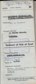
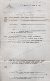
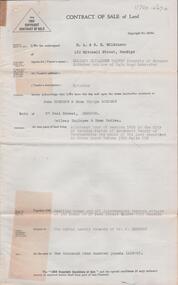
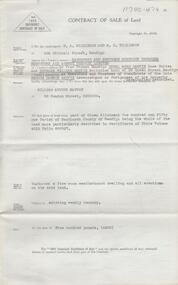
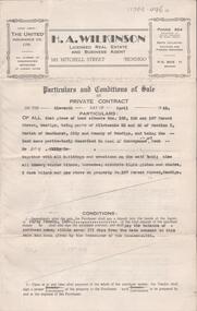
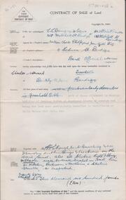
Document - H. A. & S. R. WILKINSON COLLECTION: CONTRACT OF SALE
Contract of sale of land dated 17th March, 1966 between Sandhurst and Northern District Trustees Executors for C. L. H. Seymour-Deceased (vendor) and Mr. A. Scinetti (purchaser). Solicitor for vendor: Cohen Kirby & Co. Solicitor for purchaser: Messrs. Macaboy Taylor & Taylor, Hargreaves Street, Bendigo. Property 11 Condon Street, Bendigo being part of Crown allotment 250 section H land comprised in certificate of title volume 5433 folio 443 together with a right to drainage over the land coloured yellow on the map endorsed on the said title. Price 5,000 dollars.organization, business, h.a. & s.r wilkinson real estate -
 Bendigo Historical Society Inc.
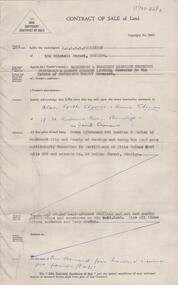
Document - H. A. & S. R. WILKINSON COLLECTION: CONTRACT OF SALE
Contract of sale of land dated 29th June, 1955between Mr. T. B. Bowery (vendor) and Mr. K. O. & Mrs. E. M. Stokes (purchaser). Property: land being allotment 17 section 71C Parish of Sandhurst City of Bendigo, being land described in Crown grant volume 1962 folio 335 and situate No. 60 Breen Street, Bendigo, together with 4 roomed weatherboard dwelling, all sundry outbuildings, all linos on floors, window blinds and electric light fittings and shades, also furniture and effects as inspected. Price: 1,050 pounds.organization, business, h.a. & s.r wilkinson real estate -
 Bendigo Historical Society Inc.
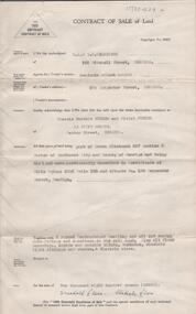
Document - H. A. & S. R. WILKINSON COLLECTION: CONTRACT OF SALE
Contract of sale of land dated 8th June, 1955 between Miss E. E. Harvey (vendor) and Mr. J & Mrs. E. G. Sherman (purchaser). Solicitor for vendor: Wilfrid J. Osborne & Osborne, Seymour. Property: land being allotment four section 147C parish of Sandhurst City of Bendigo, being land described in Crown grant volume 3580 folio 856, together with dwelling house and all improvements thereon situate No. 27 Peel Street Quarry Hill, Bendigo. Subject to weekly tenancy of Mr. J. Sherman. Price: 1,900 pounds.organization, business, h.a. & s.r wilkinson real estate -
 Bendigo Historical Society Inc.
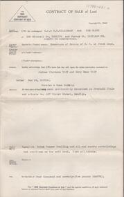
Document - H. A. & S. R. WILKINSON COLLECTION: CONTRACT OF SALE
Contract of sale of land dated 9th October, 1951 between Sandhurst and Northern District Trustees Executors and Agency Company & E. R. Garvin & D. W. Garvin as executors of and trustees of the estate of the late G. D. Garvin (vendor) and Mr. W. A. Santon (purchaser). Property: land being part of Crown allotment 151, Parish of Sandhurst City of Bendigo, being the whole of the land described in certificate of title volume 4012 folio 802327, together with a 5 room weatherboard dwelling. Subject to existing weekly tenancy. Price: 900 pounds. Hand written letter attached.organization, business, h.a. & s.r wilkinson real estate -
 Bendigo Historical Society Inc.
Document - H. A. & S. R. WILKINSON COLLECTION: CONTRACT OF SALE
Conditions of sale by private contract dated 11th April, 1945 between Miss I. M. Tregear (vendor) and G. Scarborough (purchaser). Property; land situate No. 183, 185, 187 Forest Street, Bendigo, being parts of allotments 52 and 53 section K Parish of Sandhurst City of Bendigo, land described in deed of conveyance no. 107 book No. 4004, together with all buildings on said land, also all window blinds, curtains, electric light globes and shades, 2 duck blinds and gas stove on property No. 187. Price: 1,200 pounds.organization, business, h.a. & s.r wilkinson real estate -
 Bendigo Historical Society Inc.
Document - H. A. & S. R. WILKINSON COLLECTION: CONTRACT OF SALE
Contract of sale of land dated 4th December, 1956 between Sandhurst & Northern District Trustees as executor in the estate of Catherine Beatty - deceased (seller) and Mr. A. F. & Mrs. A. Thomas (purchaser). Solicitor for purchaser Hogan & Hogan. Property: land being Crown allotment 466 section H parish of Sandhurst, County of Bendigo, land described in certificate of title volume 3047 folio 359 and situate No. 20 Hallam Street, Bendigo together with 5 roomed weatherboard dwelling and all sundry outbuildings, also all linos, blinds, curtains and lamp shades. Price 1,425 pounds.organization, business, h.a. & s.r wilkinson real estate -
 Bendigo Historical Society Inc.
Document - H. A. & S. R. WILKINSON COLLECTION: CONTRACT OF SALE
Contract of sale of land dated 15th November, 1956 between Mr. B. A. Bolton and Mr. F. B. & Mrs. V. Turner. Property: that piece of land being Crown allotment 327 section H Parish of Sandhurst city of Bendigo, land described in certificate of title volume 3556 folio 136 and situate No. 184 Carpenter Street, Bendigo, together with 6 roomed weatherboard dwelling and all sundry outbuildings, also all floor coverings, inside and outside blinds, curtains, electric light fittings and shades and electric stove. Price: 2,800 pounds. .organization, business, h.a. & s.r wilkinson real estate -
 Bendigo Historical Society Inc.
Document - H. A. & S. R. WILKINSON COLLECTION: CONTRACT OF SALE
Contract of sale of land dated 23rd May, 1956 between Mrs. M. A. L. Tobin - Mrs N. McMahon as executors of estate G. C. La Franz - deceased (sellers) and Mr. A. C. & Mrs. M. E. Tait (purchaser). Property: land being part of Crown allotment 6 section 12B Parish of Sandhurst City of Bendigo, land described in certificate of title volume 2592 folio 274 and having a frontage to Violet Street, Bendigo, together with all buildings thereon, fly wire doors, window screens and gas stove and blinds. Price: 4,075 pounds.organization, business, h.a. & s.r wilkinson real estate -
 Bendigo Historical Society Inc.
Document - H. A. & S. R. WILKINSON COLLECTION: CONTRACT OF SALE
Contract of sale of land dated 16th April 1955 between Mr. W. C. & Mrs. J. G. Philp (vendor) and Mr. C. S. Trewhella (purchaser). Property: land being part of Crown allotment 14 section 101C Parish of Sandhurst City of Bendigo, being land described in certificate of title volume 6547 folio 246, together with weatherboard dwelling and all sundry outbuildings, also all electric light fittings and shades, wall to wall carpet in hall, lino in kitchen, bathroom and washhouse and electric stovette. Price: 3,600 pounds.organization, business, h.a. & s.r wilkinson real estate -
 Bendigo Historical Society Inc.
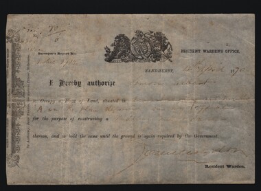
Document - MINERS RIGHT/LAND LEASE, 1870
Document. Miners Right/Land Lease. Paper document dated 4th April 1870 authorizing Simon Albert to construct a puddling mill and dam on land in Devonshire Gully. It reads: I hereby authorize Simon Albert to occupy a piece of land, situated in Devonshire Gully and marked 'A' on the plan deposited in my office for the purpose of constructing a puddling mill and dam, thereon, and to hold the same until the ground is again required by the Government. Printed by John Ferres, Government Printer, Melbourne. Signed by Resident Warden (Signature Unreadable). Lithograph drawings - one of a lion and unicorn with Latin writing.cottage, miners, miners right/land lease, simon albert, devonshire gully, john ferres governmant printer -
 Kew Historical Society Inc
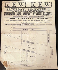
Plan, Kew! Kew!, 1888
The Land Boom of the 1880s accelerated the rate of subdivisions in Kew. This subdivision, 'Kew! Kew!' was also impacted by, or resulted from, the decision by the Victorian Government to construct the Outer Circle railway. Construction of the railway began in 1888 and was completed in 1891. Plan of an 1888 subdivision bounded by Bulleen Road (now High Street), Gladstone Street (now Campbell Street?), Park Street (now Adeney Avenue), and Belmore Road (now Harp Road). The 16 lots in the proposed subdivision are bisected by the route of the Outer Circle railway, and next to the proposed Normanby Station (later renamed East Kew). On the plan, local landmarks such as the tram terminus, the Harp of Erin hotel, and the station are located. The street where the lots are numbered , was called Welsh Street on the plan as this was the name of the vendor. Surrounding land owners are also named: G. Smith Esq, Matthew Maher Esq, and Maurice Neligan Esq.outer circle railway, land subdivisions -
 Geelong RSL Sub Branch
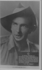
Photograph - Bruce Kingsbury VC, Bruce Kingsbury VC, Late 20th Century
This is a photograph of Pte Bruce Kingsbury VC who served with the Second AIF 1940-1942.Pte Bruce Kingsbury served in the Middle East and New Guinea. Pte Kingsbury won his VC during the Battle of Isurava. He was the first serviceman to receive the VC in Australian territory.Blue Metal Photograph Frame with Black and White photograph of B S Kingsbury VC.Inscription with the photograph - In proud memory of Pte Bruce Steel Kingsbury, VC. 2/14 Battalion who with great personal courage and at the cost of his life won the Victoria Cross at Isurava by counter attacking and clearing a path through the enemy position. "Lest We Forget"kingsbury ww2 new guinea isurava -
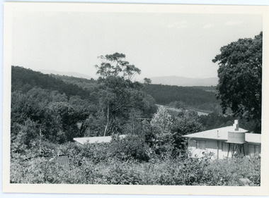 Mt Dandenong & District Historical Society Inc.
Photograph, View From Ernest Road To Site Of "Kia-Ora"
John Lundy-Clarke grew up in the Kalorama/Mt Dandenong area and later in life (1972-74) began to write a comprehensive history of the area working from an original settlement map in an effort to cover all areas. The photograph taken c1973 from Ernest Road looks over the site of the Kia-Ora guesthouse which is marked by the oalm tree that can be seen at the front of the flat roof close to the gum tree trunk. Situated on Barber’s Road, ‘Kia-Ora’ was built in 1912 by George Barber. It was later leased by a Mrs Pemberthy. “Kia-Ora’ was one of four places connected when the telephone was brought into the district in 1912. The other places were ‘Mountjoy’, ‘Cherry Farm’ and ‘Callum House’. ‘Kia-Ora’ was burnt down in 1924.Black and white photograph showing a house with water tank in right foreground and another flat roof centre foreground. There is a handwritten description by John Lundy-Clarke on the reverse.View 1973 from corner of Ernest Rd and Outlook Drive Lot 24 Village Settlement looking over the site of “Kia Ora” to the pioneers clearings. The palm tree seen above the flat roof (Rex) on left, is on the exact site of “Kia Ora”. Photo JLCernest road, john lundy-clarke, kia=ors, guest house, guesthouse -
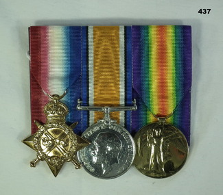 Bendigo Military Museum
Award - MEDAL SET WW1, Post 1919
Frances Madge Killicoat enlisted on 5.11.15 in the Australian Army Nursing Service age 26 years, embarked for Eygpt 12.11.1915. Joins the B.E.F in Alexandria 26.3.1916, disembarks Marseilles 4.4.1916, hospital with Hay Fever 16.6.1917 later changed to Nasal Catarrh and then with Debility, rejoin unit 4.7.1917. From there she served in No 1 ACCS, 15 CCS and 10th SH. She was discharged from the AIF on her marriage to Capt S.O.Coen AAMC on 18.11.18. She had 5 brothers in the AIF, one DOW's and one awarded a DCM. 1ACCS (1st Aust Casualty Clearing Station), 15 CCS (15th Casualty Clearing Station), 10th SH (10th Stationary Hospital)Medals, court Mounted, set of (3) Re Nurse- sister F. Killicoat. 1. 1914-15 Star. 2. War Medal 1914-18 3. Victory Medal 1914-191. "Nurse/Sister F.M Killicoat, ANS A.F 2. "S - Nurse F.M Killicoat A.I.F" 3. "Sister F.M Killicoat A.I.F"numismatics- medals- history, metalcraft -
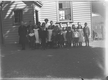 Wodonga & District Historical Society Inc
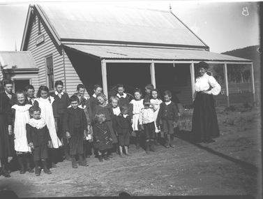
Negative - Haeusler Glass Negatives Collection - Wodonga West Primary School
The Wodonga Historical Society Haeusler Collection provides invaluable insight into life in late nineteenth and early twentieth century north east Victoria. The collection comprises manuscripts, personal artefacts used by the Haeusler family on their farm in Wodonga, and a set of glass negatives which offer a unique visual snapshot of the domestic and social lives of the Haeusler family and local Wodonga community. The Haeusler family migrated from Prussia (Germany) to South Australia in the 1840s and 1850s, before purchasing 100 acres of Crown Land made available under the Victorian Lands Act 1862 (also known as ‘Duffy’s Land Act’) in 1866 in what is now Wodonga West. The Haeusler family were one of several German families to migrate from South Australia to Wodonga in the 1860s. This digital image was produced from one of the glass negatives that form part of the collection, probably taken by Louis Haeusler (b.1887) with the photographic equipment in the Wodonga Historical Society Haeusler Collection. This item is unique and has well documented provenance and a known owner. It forms part of a significant and representative historical collection which reflects the local history of Wodonga. It contributes to our understanding of domestic and family life in early twentieth century Wodonga, as well as providing interpretative capacity for themes including local history and social history.Digital image created from the Haeusler Glass negative collection. A group of children and their teacher outside Wodonga West Primary School No. 1058. C.1910. The school was located near the current intersection of McKoy Street and the Hume Freeway in West Wodonga on land donated by J.W. Klinge, replacing an older school north of the railway line. It operated from January 1870 to May 1950 when the nine remaining students transferred to Wodonga Primary School. wodonga pioneers, haeusler family, glass negatives, dry plate photography, wodonga west primary school, schools wodonga -
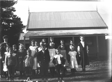 Wodonga & District Historical Society Inc
Negative - Haeusler Glass Negatives Collection - Wodonga West School and pupils
The Wodonga Historical Society Haeusler Collection provides invaluable insight into life in late nineteenth and early twentieth century north east Victoria. The collection comprises manuscripts, personal artefacts used by the Haeusler family on their farm in Wodonga, and a set of glass negatives which offer a unique visual snapshot of the domestic and social lives of the Haeusler family and local Wodonga community. The Haeusler family migrated from Prussia (Germany) to South Australia in the 1840s and 1850s, before purchasing 100 acres of Crown Land made available under the Victorian Lands Act 1862 (also known as ‘Duffy’s Land Act’) in 1866 in what is now Wodonga West. The Haeusler family were one of several German families to migrate from South Australia to Wodonga in the 1860s. This digital image was produced from one of the glass negatives that form part of the collection, probably taken by Louis Haeusler (b.1887) with the photographic equipment in the Wodonga Historical Society Haeusler Collection. This item is unique and has well documented provenance and a known owner. It forms part of a significant and representative historical collection which reflects the local history of Wodonga. It contributes to our understanding of domestic and family life in early twentieth century Wodonga, as well as providing interpretative capacity for themes including local history and social history.Digital image created from the Haeusler Glass negative collection. A group of students and their teacher standing outside Wodonga West Primary School No. 1058. C.1910. The school was located near the current intersection of McKoy Street and the Hume Freeway in West Wodonga on land donated by J.W. Klinge, replacing an older school north of the railway line. It operated from January 1870 to May 1950 when the nine remaining students transferred to Wodonga Primary School.wodonga pioneers, haeusler family, glass negatives, dry plate photography, wodonga west school -
 Wodonga & District Historical Society Inc
Negative - Haeusler Glass Negatives Collection - Teachers and Students Wodonga West Primary School
The Wodonga Historical Society Haeusler Collection provides invaluable insight into life in late nineteenth and early twentieth century north east Victoria. The collection comprises manuscripts, personal artefacts used by the Haeusler family on their farm in Wodonga, and a set of glass negatives which offer a unique visual snapshot of the domestic and social lives of the Haeusler family and local Wodonga community. The Haeusler family migrated from Prussia (Germany) to South Australia in the 1840s and 1850s, before purchasing 100 acres of Crown Land made available under the Victorian Lands Act 1862 (also known as ‘Duffy’s Land Act’) in 1866 in what is now Wodonga West. The Haeusler family were one of several German families to migrate from South Australia to Wodonga in the 1860s. This digital image was produced from one of the glass negatives that form part of the collection, probably taken by Louis Haeusler (b.1887) with the photographic equipment in the Wodonga Historical Society Haeusler Collection. This item is unique and has well documented provenance and a known owner. It forms part of a significant and representative historical collection which reflects the local history of Wodonga. It contributes to our understanding of domestic and family life in early twentieth century Wodonga, as well as providing interpretative capacity for themes including local history and social history.Digital image created from the Haeusler Glass negative collection. A group of students with their teacher standing outside their school building at Wodonga West, Victoria No. 1058. The school was located near the current intersection of McKoy Street and the Hume Freeway in West Wodonga on land donated by J.W. Klinge, replacing an older school north of the railway line. It operated from January 1870 to May 1950 when the nine remaining students transferred to Wodonga Primary School.wodonga pioneers, haeusler family, glass negatives, dry plate photography, wodonga west primary school -
 Bendigo Military Museum
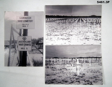
Photograph - PHOTOGRAPH, SANDAKAN WAR CEMETERY, H Eisfelder, 1947
Sandakan- Panali, North Borneo were the places of the infamous Sandakan death march. Thousands of allied POWS died. Aust lost 1787 men. Refer to the Australian War Memorial for details. Three black and white photographs taken just after WW2 .1) Photograph showing two signs, a gate post and barbed wire gate. .2) Photograph of flat land, with an enormous number of white wooden crosses. The crosses in the foreground are marked unknown. .3) photograph of flat land, with numerous white crosses. The foreground ones are marked unidentified P.W of unknown nationality .1) Photograph of signs. “Sandakan War Cemetery Turn off at Mile 7 Other sign “ Australian War graves at Mile 8” Rear has a label. All three- Sandakan (North Bendigo) photo taken early June 1947 by H. Eisfelder. ww2, p.o.w, sandakan -
 Bendigo Historical Society Inc.
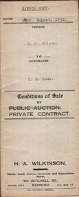
Document - H.A. & S.R. WILKINSON COLLECTION: CONDITION OF SALE
Conditions of sale by private contract dated 29th August, 1932 between J.S. Wilson (seller) and C.W. Rowe (buyer) for land situate No. 91 Booth Street, Golden Square, at present occupied by Mr. Greenway as tenant, being the land described in certificate of registration as residence area No. ? Together with 5 roomed weatherboard dwelling and all sundry. Price 260 pounds.organization, business, h.a. & s.r wilkinson real estate -
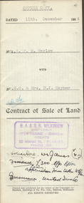
 Bendigo Historical Society Inc.
Document - H.A. & S.R WILKINSON COLLECTION: CONDITION OF SALE
Contract of sale of land dated 19th May, 1952 between Mrs. A.M. McGown (seller) and Mr. H.A. Pitson (buyer) for land being Crown allotment 6 section 128C described in certificate of title volume 6410 folio 1281821 situate No. 24 Havelock Street, Bendigo, together with 6-roomed weatherboard dwelling and all sundry. Price 2,800 pounds.organization, business, h.a. & s.r wilkinson real estate -
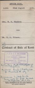 Bendigo Historical Society Inc.
Document - H.A. & S.R. WILKINSON COLLECTION: CONDITION OF SALE
Contract of sale of land dated 22nd August, 1952 between Mrs. M.S. Hindson (seller) and Mr. H. A. Pitson (buyer) for land being allotment 363 section H described in Crown grant volume 864 folio 761 situate No.10 Wolstencroft Street, Bendigo, together with 6-roomed weatherboard and brick dwelling and all sundry. Price 1,700 pounds.organization, business, h.a. & s.r wilkinson real estate -
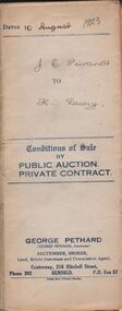 Bendigo Historical Society Inc.
Document - H.A. & S.R. WILKINSON COLLECTION: CONDITION OF SALE
Conditions of sale by private contract issued by George Pethard dated 10th August 1923 between Jane Elizabeth Neivandt (seller) and Kate Lawry (buyer) for land situate in Lilac Street Bendigo between Vertelhausen's and Bowan's residence areas land described in certificate of registration of residence area No. 20225, together with 7-roomed dwelling and all sundry. Price 350 pounds.organization, business, h.a. & s.r wilkinson real estate -
 Bendigo Historical Society Inc.
Administrative record - Land Register
Title on the front says - Bendigo Sec 12, Register. Large land register book. Board cover and back - covered by material of blue silk and leather. Paper on the inside - 101 pages - handwritten. Each page is divided into application numbers, full names, dates of application, parish of address, and details regarding the land and what is being done with it. Dates approx. ~ 1895 - 1949Written on spine - 5 12 1 7 1. Front cover large capital B on the side of the cover and in the middle is Bendigo Sec 12 Register. land register, financial, bendigo -
 Bendigo Historical Society Inc.
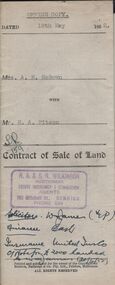
Document - H.A. & S.R. WILKINSON COLLECTION: CONTRACT OF SALE
This business was owned by father and son, Henry Archibald Wilkinson and Samuel Ronald "Ron" Wilkinson. Henry (1882-1954) was born in Shepparton and died in Bendigo. He was married to Grace Hovendon in 1908. Samuel Ronald "Ron" (1914-1995), Henry's son, was married to Florence Jean McKerlie in 1937.Contract of sale of land dated 11th December, 1954 between Mrs. H.F.M. Warlow (seller) and Mr. E.C. & Mrs. D.J. Rayner for land being Crown allotment 6 section 25 at Eaglehawk described in certificate of title volume 1217 folio 243293, situate in Junction Street Eaglehawk. Together with brick and weatherboard dwelling and all sundry. Price 700 poundsorganization, business, h.a. & s.r wilkinson real estate -
 Kew Historical Society Inc
Plan - Subdivision Plan, St Helliers Estate, Kew, circa 1910, c.1910
Pru Sanderson, in her groundbreaking ‘City of Kew Urban Conservation Study : Volume 2 - Development History’ (1988), summarised the periods of urban development and subdivisions of land in Kew. The periods that she identified included 1845-1880, 1880-1893, 1893-1921, 1921-1933, 1933-1943, and Post-War Development. These periods were selected as they represented periods of rapid growth or decline in urban development. An obvious starting point for Sanderson’s groupings involved population growth and the associated economic cycles. These cycles also highlighted urban expansion onto land that was predominantly rural, although in other cases it represented the decline and breakup of large estates. A number of the plans in the Kew Historical Society’s collection can also be found in other collections, such as those of the State Library of Victoria and the Boroondara Library Service. A number are however unique to the collection.Subdivision plans are historically important documents used as evidence of the growth of suburbs in Australia. They frequently provide information about when the land was sold on which a built structure was subsequently constructed as well as evidence relating to surveyors and real estate and financial agents. The numerous subdivision plans in the Kew Historical Society's collection represent working documents, ranging from the initial sketches made in planning a subdivision to printed plans on which auctioneers or agents listed the prices for which individual lots were sold. In a number of cases, the reverse of a subdivision plan in the collection includes a photograph of a house that was also for sale by the agent. These photographs provide significant heritage information relating house design and decoration, fencing and household gardens.In the subdivision of part of Crown Portion 82, bordered by John and Sackville Streets and Cotham and Burke Roads, over 100 lots were offered for sale. In addition to the designated lots, a number of key locations are also identified. These include the Genazzano Convent to the north of Cotham Road, the Reservoir, St Hilary’s and the land holding of Colonel Parnell on the corner of John Street and Cotham Road. On the Plan, No. 5064, is the handwritten name ‘St. Hellier’s Estate’. St. Helliers, the home of the Dumaresq family is shown beside St. Hilary’s.subdivision plans - kew, st helliers estate -
 Kew Historical Society Inc
Plan - Subdivision Plan, H C Crouch, Old Golf Links Estate, 1930s
The land in North Kew between the Outer Circle Railway and the River Yarra was released in sections. This release included 80 lots. Most of this area was released during the Depression years in the early 1930s.Subdivision plans are historically important documents used as evidence of the growth of suburbs in Australia. They frequently provide information about when the land was sold on which a built structure was subsequently constructed as well as evidence relating to surveyors and real estate and financial agents. The numerous subdivision plans in the Kew Historical Society's collection represent working documents, ranging from the initial sketches made in planning a subdivision to printed plans on which auctioneers or agents listed the prices for which individual lots were sold. In a number of cases, the reverse of a subdivision plan in the collection includes a photograph of a house that was also for sale by the agent. These photographs provide significant heritage information relating house design and decoration, fencing and household gardens.One part of a massive subdivision of the Old Golf Links Estate in North Kew of 80 allotments bordering Sutherland Avenue, Ramsay Avenue, Belford Road, Beresford Street and Coleman Avenue. Inset on the plan at the top left, the route of the Outer Circle Railway is clearly marked. The Kew Golf Links is identified in its current location. The land on which Greenacres Golf Club was to be constructed is at this time marked as ‘Recreation Ground’. The ‘new bridge’ over the Yarra at Burke Road is also marked on the inset map. The Plan identifies the surveyor (sic) H.C. Crouch BCE MVIS, 443 Little Collins St., Melbourne. The date of the subdivision auction sale in identified as Saturday September 25th at three o'clock.Annotations: "E" top left. "Golf Links" top right. Lots 73-76 ticked and listed as "6" poundssubdivisions -- kew (vic.), old golf links estate -
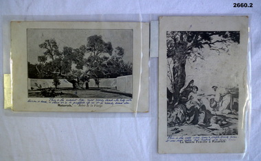 Bendigo Military Museum
Postcard - POSTCARDS WW1, 06.02.1916 (written)
2 x Laminated post cards with black & white images of Holy Land possibly Palestine. .1) Image of the ancient tree. .2) Image of a well..1) On back of card: "Aerodrome Camp Sunday 6.2.16", Top L corner: "My dear Hil" .2) On back of card: "From your loving husband Horace"documents - post cards, military history, passchendaele barracks trust -
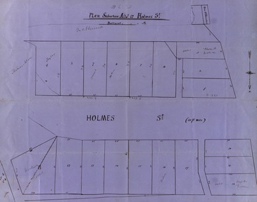 Federation University Historical Collection
Map, Plan subdivision: Allotment 12 Holmes Street, Ballarat
The Allotments drawn in Holmes Street appear to be hand drawn and showing one of the first subdivisions in Ballarat. This was begun in the 1860s. Some names are marked on the blocks - Taylor (9), Holmes (6), Robert Watson (3), Watson (16), Walter (18),Wetherly (11), Vacant (7)Blue paper with black ink showing the land blocks either side of Holmes Street Each block is numbered - 20 in all Names on some blocksNorth indicated with arrow Sizes of blocks - depth and width holmes street, subdivision, allotment 12, holmes, taylor, robert watson, watson, wetherly, vacant -
Glenelg Shire Council Cultural Collection
Photograph, View of Portland Harbour and port, 1960s
Port of Portland Authority archives.Front: (no inscriptions) Back: (no inscriptions)port of portland, lady bay