Showing 123961 items
matching main-road
-
 Whitehorse Historical Society Inc.
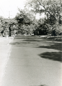
Photograph, Brunswick Road, Mitcham, 4/01/2001 12:00:00 AM
Black and white photograph looking West along Brunswick Road, Mitcham.brunswick road, mitcham. -
 Kew Historical Society Inc
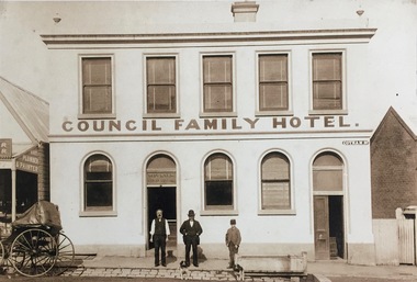
Photograph - Photograph [copy], Council Family Hotel, Cotham Road, circa 1888, c.1888
The Council Family Hotel was the fifth of the eight hotels to be licensed in Kew during the 19th Century. They were licensed in the following date order: The Woodman Inn (1854), The Harp of Erin (1854), O’Shaughnessy’s Kew Hotel (1855), the Prospect Hill Hotel (1858), the Council Family Hotel (1861), the Princess Hotel (1864), the Clifton Hotel (1868) and the Greyhound Hotel (1873).Rare photograph of a landmark Kew HotelExterior - Council Family Hotel, Cotham Road, Kew, circa 1888.Mr Pat Ryan in doorwayhotels - kew, council family hotel - kew (vic) -
 Kew Historical Society Inc
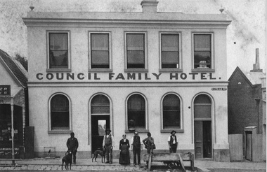
Photograph - Photograph [copy], Council Family Hotel, Cotham Road, circa 1888, c.1888
The Council Family Hotel was the fifth of the eight hotels to be licensed in Kew during the 19th Century. They were licensed in the following date order: The Woodman Inn (1854), The Harp of Erin (1854), O’Shaughnessy’s Kew Hotel (1855), the Prospect Hill Hotel (1858), the Council Family Hotel (1861), the Princess Hotel (1864), the Clifton Hotel (1868) and the Greyhound Hotel (1873).Rare photograph of a landmark hotel in KewExterior - Council Family Hotel, Cotham Road, Kew, circa 1888.hotels - kew, council family hotel - kew (vic) -
 Vision Australia
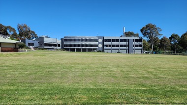
Photograph (item) - Image, Jason Morgan, Blind Cricketers pavilion, oval and rear view of Glenferrie Road building, 18/10/2023
Photograph taken by a staff member of the rear view of the Kooyong building, facing the blind cricket ground. The Charlie Bradley Cricket Pavilion is to the left.vision australia, buildings -
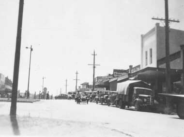
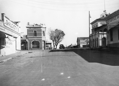 Stawell Historical Society Inc
Photograph, Wimmera Street looking North from Florence Street across Main Street with Dalgety's on the Left 1947, Post Office and Post Office Hotel on right
Wimmera Street looking North from Florence Street across Main Street. 1947 Dalgety's. Two story Commercial Bank. N.W. Ledgars Boot maker. Post Office and Post Office Hotel. Post Office Hotel opened on March 31st 1875. The first licensee was granted to H.W. Richards who held it for 3 years. Some other long running licensees were Adam Holbing 1885-1892, Mrs S.B. Whitty to 1901, Elizabeth Kyhat to 1944, Harry Kuhl , 1955-1967. When Harry died, Roy West 1967-1970 when the license was surrendered. The building is now a shopping arcade. View looking North across Wimmera and Main Street Intersection. The Commercial Bank building on left and N.W. Ledgar, Bootmaker, Post Office and Post Office Hotel on the right. stawell businesses, hotel -
 Eltham District Historical Society Inc
Photograph, Belle Vue, Livingstone Road, Eltham, c.1960, 1960c
Photo taken at time of ownership by Eric Staff. Originally purchased by pioneer Eltham farmer Henry Stooke, Belle Vue farm comprised about 56 ha (140 acres) extending northerly from the northern boundary of Holloway’s 1851 Little Eltham subdivision. On the present day map the southern boundary was just north of Elsa Court and Grove Street. The western boundary was the Diamond Creek and extended northerly to Main Road where it turns easterly towards Research. It was traversed by the main road to Kangaroo Ground and beyond and from 1912 by the railway to Hurstbridge. From 1895 the farm was owned by William Williams and his wife Mary Ann. In 1914-1915 they built a new house now known as “Belle Vue”. They sold the land in 1920 and residential subdivision began soon after that. “Belle Vue” remains today on a large residential lot in Livingstone Road. The house and many old trees on the site have been subject to a heritage overlay under the Nillumbik Planning Scheme. Despite that overlay, most of the heritage trees were removed during sub-division and development of the property.Digital file only from scan of copy on loan to EDHSbelle vue, eltham, eric staff, houses, livingstone road, staff family -
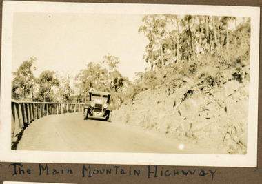 Mt Dandenong & District Historical Society Inc.
Photograph
The photograph shows an old car rounding a bend on what is now the Mt Dandenong Tourist Road. Around 1930 it would have been called the CRB Road or the Main Road. The photograph is in the Ivy Child Album. Ivy May Child (1910 – 1989) was the daughter of Arthur Edward (Ted) Child (1878 – 1964) and Ethel May Madden (1888 – 1970). Ted Child was the son of Matthew Francis Child (1839 – 1933) and Martha Jeeves (1857 – 1926). He was the grandson of one of the early pioneers Francis Child. Ivy grew up on the family property on Childs Road and took many photographs. Most of these are glued into her photo album. The album covered the years from c1927 – 1932. Ivy married Henry William Burgess (1906 – 1968) in 1944.Sepia coloured photograph showing an old car rounding a bend in the road.Below photograph in album: The Main Mountain Highwaymain road, crb road mt dandenong tourist road, car, automobile, ivy child, kalorama -
 Surrey Hills Historical Society Collection
Photograph, 44 Guildford Road, Surrey Hills, c1915, 1913-1915
The gentleman in the photo is an estate agent. According to a grandson (REF: Email 1/8/2020) the original photos is thought to have been a publicity photo for the real estate agency. Carl Theodore Offszanka (1874-1944) was born in Germany. He is listed in electoral rolls at 44 Guildford Road from 1915, occupation furrier, with his wife Ida (nee Schade, 1882-1963), also born in Germany. They were married in Victoria in 1908. In later electoral rolls at the same address are Erna Helena (b 1913; d 1996) and Maria Eliese (b 1910; m Benedict Francis Rieusset in 1936). Both daughters are listed as typists. Also listed is Bernard George (b 1914; d 1987) who in later electoral rolls is described as a process worker. He served in the AIF in the Second World War. Not listed is Carl Bernard b 1909. The Offszanka family lived at 44 Guildford Road from 1913 until post-1980; they came to Surrey Hills from Richmond. Their home was called 'Westfalia' (ref: 1919 electoral roll), presumably after the region in NW Germany. It is not known when Carl and Ida migrated from Germany. This home has had a 2nd storey added to it in late 1990s. According to a family descendant (REF: Email 1/8/20 from grandson) Carl Theodor Offszanka purchased the home in 1913 for £616. He also purchased the adjoining vacant block of land at 42 Guildford Road and ran a large orchard on it before later selling it. This appears to have been between 1920-1930. The family continued to occupy the house until after 1980 when Erna Helena and Bernard George are listed in the electoral rolls. Our property register lists Erna Helena Offszanka as the last member there. She died on 5 May 1996. Black and white photo of a ? dark-stained timber Edwardian home at 44 Guildford Road, Surrey Hills. It has 2 brick chimneys, a corrugated iron roof and timber fretwork to the veranda. There is a single window to the veranda, 2 single windows down the LHS (facing) side of the house and a double window to the RHS (facing) side of the house. This appears to have coloured glass to the top section. The gable is decorated with timber and stucco and has a simple finial. The house has a simple timber picket fence and a driveway down the LHS (facing), in which a carriage is located. A gentleman in a hat stands on the veranda. A tall Victorian building can be seen in the far distance, on Canterbury Road.edwardian architecture, houses, guildford road, mr bernard george offszanka, mrs ida offszanka, miss ida schade, miss erna helena offszanka, miss marie eliese offszanker, furriers, mr carl theodor offszanka, westfalia, mr carl bernard offszanka -
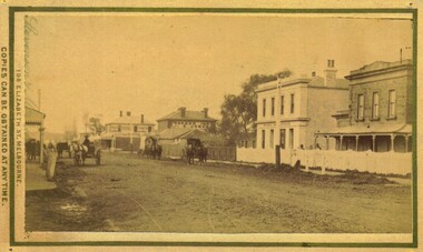 Bacchus Marsh & District Historical Society
Photograph, Main Street Bacchus Marsh 1883 looking east
View of Main Street Bacchus Marsh 1883, showing early notable buildings on the southern side of the street, including the Courthouse, National Bank of Australasia, Border Inn, Hall of Commerce building. Small sepia unframed photograph on card with gold border framing photograph. Housed in the album, 'Photographs of Bacchus Marsh and District in 1883 by Stevenson and McNicoll'. Several horse-drawn vehicles can be seen travelling along an unmade road. Piles of excavated dirt can be seen along the side of the road. Four substantial two-storeyed buildings can be seen along the southern side of the street.On the front: Stevenson & McNicoll. Photo. 108 Elizabeth St. Melbourne. COPIES CAN BE OBTAINED AT ANY TIME. On the back: LIGHT & TRUTH inscribed on a banner surmounted by a representation of the rising sun. Copies of this Portrait can be had at any time by sending the Name and Post Office Money Order or Stamps for the amount of order to STEVENSON & McNICOLL LATE BENSON & STEVENSON, Photographers. 108 Elizabeth Street, MELBOURNE. stevenson and mcnicoll 1883 photographs of bacchus marsh and district, bacchus marsh roads and streets, bacchus marsh main street 19th century -
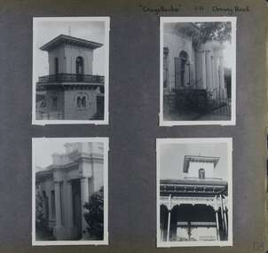 Glen Eira Historical Society
Album - Album page, Craigellachie, 273 Orrong Road, Circa 1972
This photograph is part of the Caulfield Historical Album 1972. This album was created in approximately 1972 as part of a project by the Caulfield Historical Society to assist in identifying buildings worthy of preservation. The album is related to a Survey the Caulfield Historical Society developed in collaboration with the National Trust of Australia (Victoria) and Caulfield City Council to identify historic buildings within the City of Caulfield that warranted the protection of a National Trust Classification. Principal photographer thought to be Trevor Hart, member of Caulfield Historical Society. Most photographs were taken between 1966-1972 with a small number of photographs being older and from unknown sources. All photographs are black and white except where stated, with 386 photographs over 198 pages. From Victorian Heritage Database citation HO40 Craigellachie 2b & 2c Lynedoch Avenue Caulfield North https://vhd.heritagecouncil.vic.gov.au/places/35209 as at (28/10/2020) Craigellachie" is situated at No. 2B Lynedoch Avenue, Caulfield North, and was built for the noted investor, pastoralist and politician, William Pearson, not earlier than 1864 and possible in 1876, undergoing several substantial and contributory extensions during the nineteenth century. It is historically and aesthetically significant. From Victorian Heritage Database citation for HO40 Craigellachie https://vhd.heritagecouncil.vic.gov.au/places/35209 as at (28/10/2020) It is historically significant (Criterion A) as the Melbourne home of William Pearson, MLA, MLC and principal shareholder in Walhalla's Long Tunnel Extended Gold Mining Co. which sustained the township well past the turn of the twentieth century and occupied fifth place amongst Victoria's richest mines. It is aesthetically significant (Criterion E) for its capacity to demonstrate Pearson's continuing financial success throughout the mid to late nineteenth century, the additions associated with the tower being most noteworthy as an example of the lasting appeal of the Italian Style, popularized in the pattern books of the day. The Ailanthus altissima (Tree of Heaven) is significant as an outstanding example of a species that is rare in cultivation, as well as for its very high aesthetic value. The Araucaria bidwilli is notable as a fine example of a species infrequently planted in Melbourne and rarely found in private suburban gardens.Page 156 of Photograph Album with four landscape photographs of Craigellachie - near views of architectural features. Handwritten: "Craigellachie" 273 Orrong Road [top right] / 156 [bottom right]trevor hart, verandah, orrong road, tower, curved windows, decorative brackets, italianate, mansion, 1870's, william pearson, inkerman street, apartments, spire, decorative plaster work, rendered walls, ornamentation, arched windows, moulded ornaments, 1860's, lynedoch avenue, classical style, caulfield north, craigellachie, cast iron work, victorian style, balaclava, st kilda east, gardens, ailanthus altissima, araucaria bidwilli, porches, trees -
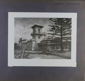 Glen Eira Historical Society
Album - Album page, Craigellachie, 273 Orrong Road, Circa 1972
This photograph is part of the Caulfield Historical Album 1972. This album was created in approximately 1972 as part of a project by the Caulfield Historical Society to assist in identifying buildings worthy of preservation. The album is related to a Survey the Caulfield Historical Society developed in collaboration with the National Trust of Australia (Victoria) and Caulfield City Council to identify historic buildings within the City of Caulfield that warranted the protection of a National Trust Classification. Principal photographer thought to be Trevor Hart, member of Caulfield Historical Society. Most photographs were taken between 1966-1972 with a small number of photographs being older and from unknown sources. All photographs are black and white except where stated, with 386 photographs over 198 pages. From Victorian Heritage Database citation for HO40 Craigellachie 2b & 2c Lynedoch Avenue Caulfield North https://vhd.heritagecouncil.vic.gov.au/places/35209 as at (28/10/2020) Craigellachie" is situated at No. 2B Lynedoch Avenue, Caulfield North, and was built for the noted investor, pastoralist and politician, William Pearson, not earlier than 1864 and possible in 1876, undergoing several substantial and contributory extensions during the nineteenth century. It is historically and aesthetically significant. From Victorian Heritage Database citation for HO40 Craigellachie https://vhd.heritagecouncil.vic.gov.au/places/35209 as at (28/10/2020) It is historically significant (Criterion A) as the Melbourne home of William Pearson, MLA, MLC and principal shareholder in Walhalla's Long Tunnel Extended Gold Mining Co. which sustained the township well past the turn of the twentieth century and occupied fifth place amongst Victoria's richest mines. It is aesthetically significant (Criterion E) for its capacity to demonstrate Pearson's continuing financial success throughout the mid to late nineteenth century, the additions associated with the tower being most noteworthy as an example of the lasting appeal of the Italian Style, popularized in the pattern books of the day. The Ailanthus altissima (Tree of Heaven) is significant as an outstanding example of a species that is rare in cultivation, as well as for its very high aesthetic value. The Araucaria bidwilli is notable as a fine example of a species infrequently planted in Melbourne and rarely found in private suburban gardens.Page 158 of Photograph Album with one image of Craigellachie's exterior. Handwritten: "Craigellachie" 273 Orrong Road [top right] / 158 [bottom right]trevor hart, verandah, orrong road, tower, curved windows, decorative brackets, rendered, craigellache, italianate, mansion, 1870's, william pearson, inkerman street, apartments, spire, decorative plaster work, rendered walls, ornamentation, arched windows, moulded ornaments, 1860's, lynedoch avenue, classical style, caulfield north, craigellachie, land subdivision, gardens, late victorian style, cast iron work, st kilda east, ailanthus altissima, araucaria bidwilli, trees -
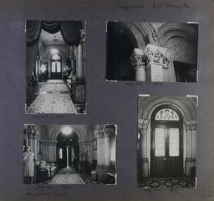 Glen Eira Historical Society
Album - Album page, Craigellachie, 273 Orrong Road, Circa 1972
This photograph is part of the Caulfield Historical Album 1972. This album was created in approximately 1972 as part of a project by the Caulfield Historical Society to assist in identifying buildings worthy of preservation. The album is related to a Survey the Caulfield Historical Society developed in collaboration with the National Trust of Australia (Victoria) and Caulfield City Council to identify historic buildings within the City of Caulfield that warranted the protection of a National Trust Classification. Principal photographer thought to be Trevor Hart, member of Caulfield Historical Society. Most photographs were taken between 1966-1972 with a small number of photographs being older and from unknown sources. All photographs are black and white except where stated, with 386 photographs over 198 pages. From Victorian Heritage Database citation for HO40 Craigellachie 2b & 2c Lynedoch Avenue Caulfield North https://vhd.heritagecouncil.vic.gov.au/places/35209 as at (28/10/2020) Craigellachie" is situated at No. 2B Lynedoch Avenue, Caulfield North, and was built for the noted investor, pastoralist and politician, William Pearson, not earlier than 1864 and possible in 1876, undergoing several substantial and contributory extensions during the nineteenth century. It is historically and aesthetically significant.From Victorian Heritage Database citation for HO40 Craigellachie https://vhd.heritagecouncil.vic.gov.au/places/35209 as at (28/10/2020) It is historically significant (Criterion A) as the Melbourne home of William Pearson, MLA, MLC and principal shareholder in Walhalla's Long Tunnel Extended Gold Mining Co. which sustained the township well past the turn of the twentieth century and occupied fifth place amongst Victoria's richest mines. It is aesthetically significant (Criterion E) for its capacity to demonstrate Pearson's continuing financial success throughout the mid to late nineteenth century, the additions associated with the tower being most noteworthy as an example of the lasting appeal of the Italian Style, popularized in the pattern books of the day. The Ailanthus altissima (Tree of Heaven) is significant as an outstanding example of a species that is rare in cultivation, as well as for its very high aesthetic value. The Araucaria bidwilli is notable as a fine example of a species infrequently planted in Melbourne and rarely found in private suburban gardens.Page 160 - four photographs of Craigellachie interiors. Handwritten: "Craigellachie" 273 Orrong Road [top right] / 156 [bottom right]trevor hart, orrong road, italianate, mansion, 1870's, william pearson, inkerman street, decorative plaster work, rendered walls, ornamentation, moulded ornaments, 1860's, lynedoch avenue, classical style, caulfield north, craigellachie, late victorian style, st kilda east, hallways, arched doors, stained glass, mrs francis, furnishings -
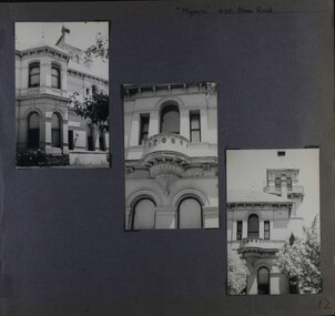 Glen Eira Historical Society
Album - Album page, Myoora, 405 Alma Road, Circa 1972
This photograph is part of the Caulfield Historical Album 1972. This album was created in approximately 1972 as part of a project by the Caulfield Historical Society to assist in identifying buildings worthy of preservation. The album is related to a Survey the Caulfield Historical Society developed in collaboration with the National Trust of Australia (Victoria) and Caulfield City Council to identify historic buildings within the City of Caulfield that warranted the protection of a National Trust Classification. Principal photographer thought to be Trevor Hart, member of Caulfield Historical Society. Most photographs were taken between 1966-1972 with a small number of photographs being older and from unknown sources. All photographs are black and white except where stated, with 386 photographs over 198 pages.Victorian Heritage Register (VHR) Number H0490 From the Victorian Heritage Register Database - Citation for Myoora https://vhd.heritagecouncil.vic.gov.au/places/275 (as at 6/10/2020) Myoora, 405 Alma Road, North Caulfield, was designed by Reed, Henderson & Smart and can be attributed to Anketell Henderson. It was built in 1886 and 1887 for Thomas Christian, who had founded the fabled gold mine, the Day Dawn at Charters Towers. He never occupied the house although his widow lived there for some time. The house was subdivided into three and later six flats. Myoora was one of many large mansions on broad acres with gardens in Caulfield. Perhaps the grandest was Labassa. The mansions date from the 1850s through to the late 1890s. The siting of Myoora on a ridge influenced its planning and composition. A central hall and corridor along the ridge is entered from the centre of the more formal north facade. The entrance is marked by an elaborately detailed tower. A stair turret provides a second accent. The western end of the building is completed by a massively detailed chimney as the service wing. The south facade enjoyed an outlook to port phillip from a two-storey cast iron verandah. Bay windows, chimneys, the tower and the turret and minor details are brought together in a sophisticated asymmetrical composition. This is reflected in the planning. The asymmetry of Myoora pivoting on the tower is the most notable feature of the building. The walls are built of cement rendered brick. The cement render has not been painted. The roof is slate. The balconies and verandah are cast iron. The footings and cellar are bluestone. The architectural firm Reed, Henderson & Smart was very prominent in Victoria in the nineteenth century. Anketell Henderson was an eminent and well respected member of the profession. He worked successfully in London and interstate as well as in Victoria. They were better known for commercial and public buildings. Myoora is an important private commission. The style of Myoora is a combination of details from the Continental and English Renaissance through the boom style and the Queen Anne style. There is also an early influence from the American Romanesque style especially in the stair turret. The latter style was important at the turn of the century and Myoora is a significant precursor. Other buildings of a similar scale survive in Caulfield and elsewhere. Labassa, the most fabulous, is quite different stylistically as are most of the other comparable mansions. Stonnington is perhaps closer but relies on different details from the Queen Anne style and lacks any American influence. For its historical associations through its owners and architects, for its style and composition and for its intactness, Myoora is significant at a State level. The craftmanship of Myoora is what could be expected of a building of the time and type. It is relatively intact and in fair condition. The main staircase has been removed, minor alterations to decorative features have occurred and additions have been made to the exterior.Page 12 of Photograph Album including three black and white photographs. The photos are in a portrait orientation and arranged diagonally across the page from top left to bottom right.Handwritten: "Myoora" 405 Alma Road[top right] /12 [bottom left]caulfield north, trevor hart, alma road, mansion, myoora, tower, thomas christian, 1880's, queen anne, cement rendered brick, unpainted, balconies, verandahs, anketell henderson, continental and english renaissance, american romanesque, cast iron balconies, cast iron work, reed henderson & smart, flats, asymmetrical style, slate roofs -
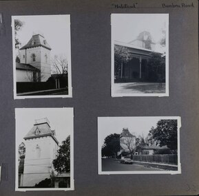 Glen Eira Historical Society
Album - Album page, Halstead, Bambra Road, Circa 1972
This photograph is part of the Caulfield Historical Album 1972. This album was created in approximately 1972 as part of a project by the Caulfield Historical Society to assist in identifying buildings worthy of preservation. The album is related to a Survey the Caulfield Historical Society developed in collaboration with the National Trust of Australia (Victoria) and Caulfield City Council to identify historic buildings within the City of Caulfield that warranted the protection of a National Trust Classification. Principal photographer thought to be Trevor Hart, member of Caulfield Historical Society. Most photographs were taken between 1966-1972 with a small number of photographs being older and from unknown sources. All photographs are black and white except where stated, with 386 photographs over 198 pages.From the Victorian Heritage Register Database - Citation for Halstead, 23 Bambra Road as at (as at 12/10/2020) https://vhd.heritagecouncil.vic.gov.au/places/276 Halstead is believed to be the oldest standing residence in Caulfield constructed in 1857 with subsequent additions during the 19th Century. The house was built for and owned by James Dickson, a stock agent, until his death in 1880. Although on a much reduced parcel of land, Halstead is one of the few remaining remnants of Caulfield when it was an area of mansion houses occupied by town residing squatters, professional and business men. It is important for its place in the socio-economic history of south eastern suburban Melbourne, the inland pattern of development stretching from Malvern through Murrumbeena. Architecturally the single storey building displays a history of alteration and addition. Its main front presents with a single storey cast iron verandah across the full width, including the two pavilion wings at each end. Located towards the rear on the Halstead Street side is the substantial three storey tower with its Mansard roof and cast-iron balustrade which makes the house clearly visible from Halstead Street and Bambra Road. Because of internal alteration the importance of the building relates to the exterior only of the main house. Halstead is believed to be the oldest standing residence in the city of Caulfield. https://vhd.heritagecouncil.vic.gov.au/places/43645 "Halstead" is regionally important as a surviving large villa from the early Victorian (1850's) period, offering insights into the lifestyles of the privileged in Caulfield at that time. The later tower is of architectural interest for its use of Medieval Romanesque enrichment.Page 32 of Photograph Album with four photographs of the exterior of this double storey house, focussing on different angles for the house's tower.Hand written: "Halstead" Bambra Road [top right] / 32 [bottom right] trevor hart, caulfield north, bambra road, 1850's, halstead, james dickson, mansion, villa residence, cast iron verandah, pavillion wings, halstead street, victorian, tower, balustrading, decorative brackets, mansard roof, brick, cast iron, slate roof, curved windows, single storey mansions, streetscapes, medieval romanesque style, slate roofs, gardens, cast iron work -
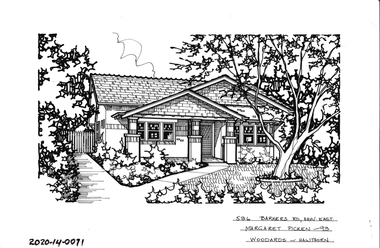 Hawthorn Historical Society
Drawing - Property Illustration, 536 Barkers Road, Hawthorn
'After training as a Cartographic Draftsman within the mining industry, I worked as a property illustrator for real estate firms in the eastern suburbs of Melbourne for 23 years from 1983. I initially photographed houses with a Polaroid camera and made a 'thumbnail' sketch while there. The photos were used to scale off a sketch in pencil and then that sketch was overlaid with drafting film and the 'pen and ink' completed. The pens I used were the Rotring ‘Rapidigraph’ drafting pens. The ink was also made by Rotring (German).The film was ‘Rapidraw’, polyester drafting film, double matte. It takes a very fine line and doesn’t bleed. As well as house sketches, there were often floor plans and site plans ordered. Aerial sketches were ordered when the property needed an overall view.' (Margaret Picken, 2020)This property illustration is one of a series created by Margaret Picken for a range of real estate agents in Melbourne between c. 1983 and c. 2006. Each work is signed and dated by the artist.Gift of Margaret Picken, 2020Pen and ink property illustration on drafting film of 536 Barkers Road, Hawthorn by Margaret Picken.536 Barkers Road, Haw East, Margaret Picken '93. Woodards - Hawthorn.artist - margaret picken 1950- -
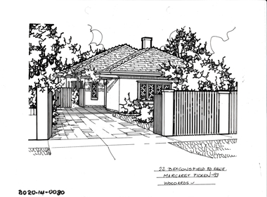 Hawthorn Historical Society
Drawing - Property Illustration, 22 Beaconsfield Road, Hawthorn
'After training as a Cartographic Draftsman within the mining industry, I worked as a property illustrator for real estate firms in the eastern suburbs of Melbourne for 23 years from 1983. I initially photographed houses with a Polaroid camera and made a 'thumbnail' sketch while there. The photos were used to scale off a sketch in pencil and then that sketch was overlaid with drafting film and the 'pen and ink' completed. The pens I used were the Rotring ‘Rapidigraph’ drafting pens. The ink was also made by Rotring (German).The film was ‘Rapidraw’, polyester drafting film, double matte. It takes a very fine line and doesn’t bleed. As well as house sketches, there were often floor plans and site plans ordered. Aerial sketches were ordered when the property needed an overall view.' (Margaret Picken, 2020)This property illustration is one of a series created by Margaret Picken for a range of real estate agents in Melbourne between c. 1983 and c. 2006. Each work is signed and dated by the artist.Gift of Margaret Picken, 2020Pen and ink property illustration on drafting film of 22 Beaconsfield Road, Hawthorn by Margaret Picken.22 Beaconsfield Road, Haw E, Margaret Picken '93. Woodards - Hawthorn.artist - margaret picken 1950- -
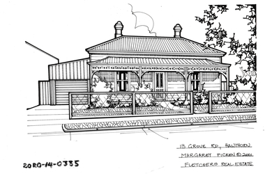 Hawthorn Historical Society
Drawing - Property Illustration, 13 Grove Road, Hawthorn
'After training as a Cartographic Draftsman within the mining industry, I worked as a property illustrator for real estate firms in the eastern suburbs of Melbourne for 23 years from 1983. I initially photographed houses with a Polaroid camera and made a 'thumbnail' sketch while there. The photos were used to scale off a sketch in pencil and then that sketch was overlaid with drafting film and the 'pen and ink' completed. The pens I used were the Rotring ‘Rapidigraph’ drafting pens. The ink was also made by Rotring (German).The film was ‘Rapidraw’, polyester drafting film, double matte. It takes a very fine line and doesn’t bleed. As well as house sketches, there were often floor plans and site plans ordered. Aerial sketches were ordered when the property needed an overall view.' (Margaret Picken, 2020)This property illustration is one of a series created by Margaret Picken for a range of real estate agents in Melbourne between c. 1983 and c. 2006. Each work is signed and dated by the artist.Gift of Margaret Picken, 2020Pen and ink property illustration on drafting film of 13 Grove Road, Hawthorn by Margaret Picken.13 Grove Road, Hawthorn, Margaret Picken c2001. Fletchers Real Estate. artist - margaret picken 1950- -
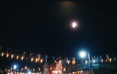 Stawell Historical Society Inc
Photograph - Slide, Stawell Gift Main Street at night
Night Scene of Main Street showing flags and Lights -
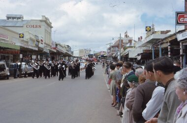 Stawell Historical Society Inc
Photograph - Slide, Stawell Band Marching in Main Street
Band marching in Main Street with crowds lining the Street -
 Whitehorse Historical Society Inc.
Photograph - Strip and photocopy, Corner South Parade & Main Street, Blackburn, 1/08/1976 12:00:00 AM
strip photos of South Parade and Main Street Blackburnmain street, blackburn -
 Department of Health and Human Services
Photograph, Colanda Grounds - Main Kitchen
The Colac, Victoria-based Colanda Centre was one of the last Victorian institutions and offered disability accommodation from 1976, when it was established, until 2019, with its closure.Digitised colour photograph of the Colanda Centre main kitchen -
 Department of Health and Human Services
Photograph, Colanda grounds - main driveway gardens
The Colac, Victoria-based Colanda Centre was one of the last Victorian institutions and offered disability accommodation from 1976, when it was established, until 2019, with its closure.Digitised colour photograph of Colanda's main driveway gardens. colanda, colac, disability services, residential services, disability, digitised photograph -
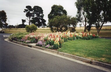
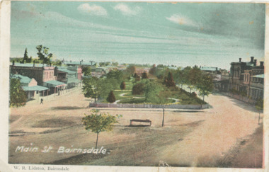 Lakes Entrance Historical Society
Postcard - Main Street gardens Bairnsdale Victoria, c1900
Colour postcard Main Street gardens Bairnsdale Victoriagardens, businesses -
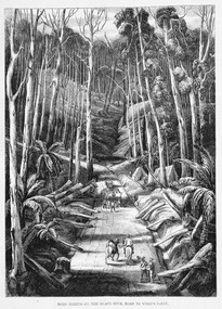 Marysville & District Historical Society
Work on paper (item) - Print of wood engraving, Ebenezer and David Syme, Road Making on the Black Spur, Road to Wood's Point, 1867
A copy of an early wood engraving of the construction of the road over the Black Spur in Victoria.A copy of an early wood engraving of the construction of the road over the Black Spur in Victoria. The Black Spur is known to be one of Victoria's most scenic drives. The road winds through a majestic forest of trees and tree ferns from Healesville to Narbethong and is part of the Maroondah Highway.black spur, wood's point, narbethong, maroondah highway, victoria, wood engraving -
 Ringwood and District Historical Society
Photograph, Maroondah Highway Central, Ringwood. Main Street shops looking east from near station entrance, c1921
Black and white photograph(2 copies- 1 large, 1 smaller)Written below photograph, "Main Street Shops". -
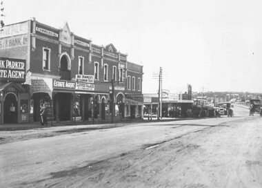
 Ringwood and District Historical Society
Photograph, Main Street shops looking east - Maroondah Hwy, Ringwood - 1935
Written on back of photograph, "Main Street, Ringwood". -
 Tatura Irrigation & Wartime Camps Museum
Photograph, The Goulburn-Waranga Main Channel, 1957
Taken by the photographer for Victoria State Rivers and Water Supply Commission.Sepia photograph - dry mounted on cream cardboard. Wide view of water-filled channel, trees lining each bank Large photographAbove photo - "The Goulburn Waranga Main Channel"irrigation, goulburn, waranga, victoria state rivers and water supply commission, channel -
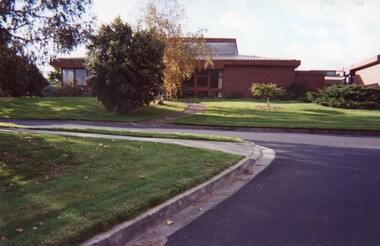
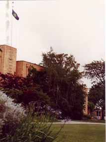 University of Melbourne, Burnley Campus Archives
Photograph - Colour print, Peter Esdale, Main Building VCAH Burnley 1991, 1991
Colour Photograph by taken by P. Esdale from the S.E. Part of the Administration Building with garden beds in front. VCAH flag flying from roof.On reverse, "Main building VCAH Burnley 1991."1991, administration building, garden view, main building, vcah flag -
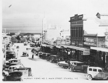 Stawell Historical Society Inc
Photograph, Murray Views, Main Street in Stawell c1950 -- Postcard, C 1950
Sister of Donor Visited Stawell in th e1950'2 When she Purchased thes Murray Views Cards. The Cards were produced for sale to touristsSet of 8 Murry Views Postcards No 1 to No 8 C. 1950Murray Views No.5 Main Street Stawell -
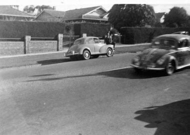 Surrey Hills Historical Society Collection
Digital photo, George L Coop, Redex trial on Whitehorse Road, Mont Albert, 1953, 1953
The Redex Reliability Trial 1953 -The first Redex round-Australia reliability trial covered of 6,500 miles (10,500 km), and had a first prize of £1,000. It attracted both amateur and professional drivers in a variety of cars. The route passed through Brisbane, Rockhampton, Townsville, Darwin, Alice Springs, Adelaide and Melbourne before returning to Sydney and attracted much public interest. At the time the idea of driving huge distances around the country in ordinary cars was novel and the logistics were challenging. In many parts of the country there simply wasn’t adequate accommodation or suitably located refuelling stops. The Shell Company facilitated the race by placing petrol dumps along the 5000 km route between Townsville and Adelaide. The race began at the Sydney Showground on 30 August when 192 cars left at three-minute intervals. Of the twenty top finalists, two thirds were sponsored. Ken Tubman and John Marshall won the trial in a Peugeot 203. A black & white photo taken in Whitehorse Road, Mont Albert during the 1953 Redex Trial as a Volkswagen is passing 688 Whitehorse Road on the extreme left. The VW appears to have advertising on its panels indicating it was a competitor in the trial. On the far side of the road is a Morris Minor with a hatted man sitting on the bonnet. The houses in the background are partly obcsured by large hedges.george coop, mont albert, volkswagen, morris minor, redex trial, whitehorse road