Showing 2266 items
matching map collections
-
 Bendigo Historical Society Inc.
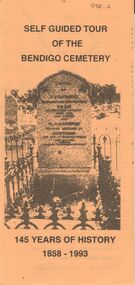
Document - BENDIGO CEMETERIES COLLECTION: SELF GUIDED TOUR BENDIGO CEMETERY DOCUMENT
BHS CollectionYellow trifold document: Self Guided tour of the Bendigo Cemetery, 145 Years of History 1858 - 1993. Document contains a map of a section of the Bendigo Cemetery, 29 graves are numbered and described. E.g. J.C.T. Ballerstedt, Quartz Reefer, Robert Clark 8 hour day pioneer, Giuseppe Favaloro restaurateur. Hitching rail outside cemetery gates is noted.bendigo, cemetery, bendigo cemetery tour -
 Bendigo Military Museum
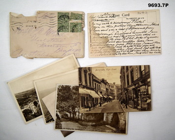
Postcard - ENVELOPE AND POSTCARDS WW1, C.1917
The postcards are addressed to the Mother of C.J.C. McQuie MM, all written in 1917. .2) Card talks about his leave plus sending a map home of the ground over where he was W.I.A. Card scene is Hele Beach Ifracombe. .3) "Combe Martin" .4) "The Torrs Walk Ifracombe. .5) "Ifracombe, Santern Hill & Hillsborough". .6) "The Dripping Well Barnstaple" .7) "Barnstaple High Street" Items in the collection relating to C.J.C. McQuie MM, refer cat No 9680P for his service details. All the postcards are in sepia tone. .1) Envelope light brown colour, has 4 green stamps, addressed in purple indelible pen. .2) Postcard, view across a valley, text on rear in black pen. .3) Postcard, view across a Valley, text on rear in black pen. .4) Postcard, view from Cliffs to Ocean, text on rear in black pen. .5) Postcard, view across Ocean to Hills. .6.) Postcard, view of a well in a garden. .7) Postcard, street view in a town..2) On rear, "14th Nov17, Royal Clarence Hotel Ifracombe" .3) On rear, "This is a view of Hillsborough" .4) On rear, "Walked around here yesterday & then to L...& Bull Pt Lighthouse" .5) On rear, "Royal Clarence Hotel Ifracombe 16/11/17 - Great views from the top of this hill - I am walking to Barnstable today, 12 miles from here"postcards, mcquie -
 Bendigo Military Museum
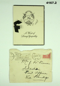
Card - SYMPATHY CARD and ENVELOPE, ATLAS PRESS Marlborough series, Both 1917
Items in the collection relating to George Frederick Pierce DCM. Refer Cat No 4136P for his service details, award and death Part of the collection of William (Bill) Thomason, refer Cat No 4136P..1) four page folding card, front cover has a map of Australia, crossed rifles, wreath, Corolla, inside has a short poem headed “He hath fought the good fight”. Next page a brief sympathy message with hand written entry in ink, a small black ribbon holds the pages together. .2) Yellowish envelope with two circular stamp marks, red 1 penny stamp and addressed in black pen. Envelope is stamped “20 NOV 2017.1) front cover,” A world of Sympathy”. Inside in ink from “Hilda C Stephens” .2) on front in black pen, “Mrs J Pierce Sebastian Post Office Via Bendigo”sympathy, cards, military -
 Bendigo Historical Society Inc.
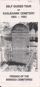
Document - BENDIGO CEMETERIES COLLECTION: SELF GUIDED TOUR EAGLEHAWK CEMETERY DOCUMENT
BHS CollectionWhite trifold document. Self guided tour of Eaglehawk Cemetery 1864 - 1993 Friends of the Bendigo Cemeteries. Document details significant graves in the old monumental section 1864 - Map of graves and 35 graves described.Annette O'Donohue, Bev Hanson.bendigo, cemetery, eaglehawk cemetery -
 Bendigo Historical Society Inc.
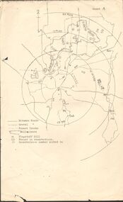
Map - PETER ELLIS COLLECTION: MAP OF WHIPSTICK
... PETER ELLIS COLLECTION: MAP OF WHIPSTICK...MAP Bendigo Peter Ellis Collection The Whipstick Flagstaff ...Two maps of the Whipstick - Sheet A and Sheet B. Sheet A shows the Whipstick in relation to Bendigo and some surrounding places. Bitumen roads, gravel, forest tracks, Mallee Areas, Flagstaff Hill, fenced in reservations and reservoirs are marked. Also, a circle and part circles of 5-, 10-, 15- and 20-mile radius is marked. North & South are marked. Sheet B is an enlarged area of the Whipstick Scrub area. North and South is marked. There are a number of letters written over both maps.map, bendigo, peter ellis collection, the whipstick, flagstaff hill -
 Bendigo Historical Society Inc.
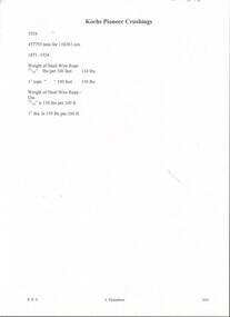
Document - KOCH'S PIONEER QUARTZ MINING AND CRUSHING COMPANY, NO LIABILITY - SHARE CERTIFICATE
Koch's Pioneer Quartz Mining and Crushing Company, No Liability Long Gully Bendigo Share Certificate. Distinctive Numbers 48164 to 48213 in the name of William Grattan of St Kilda. Certificate Number 2930. Dated 7th December 1911. Signed by ?, Hugh Boyd, Directors and J. H. Craig, Manager. On the back is a map of the lease showing where the shaft is and a measurement of 450 yards from one side of the lease to the other beside the shaft. The lease is an irregular shape. Adjoining leases mentioned are Windmill Hill Co., G. Lansell's Sandhurst Mine, Cornish United Co. and the Hercules & Energetic Co. Arthur T. Walker, M. S. printed at the bottom. Albert Richardson Collectionmining, parish map, koch's pioneer, koch's pioneer quartz mining and crushing company, no liability, koch's pioneer quartz mining and crushing company, no liability share certificate, william grattan, hugh boyd, j h craig, arthur t walker, windmill hill co., g lansell's sandhurst mine, cornish united co., hercules & energetic co. -
 Bendigo Historical Society Inc.
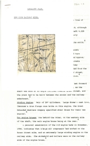
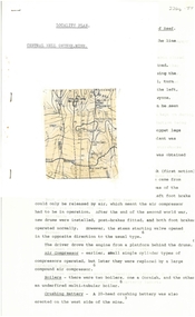
Document - ALBERT RICHARDSON COLLECTION: NEW CHUM RAILWAY MINE, GOLDEN SQUARE
Three-page typed document plus map. Document details location and history of the New Chum Railway Mine, Golden Square and includes: depth of shaft, size of lease, locality, poppet legs, winding engine, engine houses, crushing battery, best gold obtained, prominence, and total gold production and dividends. References provided. Document forms part of research referred to in Albert Richardson's paper 2264.70.bendigo, mining, new chum railway gold mine -
 Bendigo Historical Society Inc.
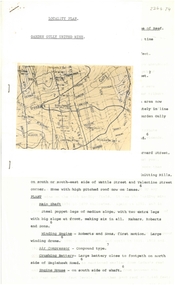
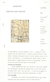
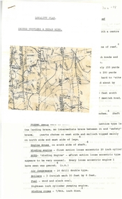
Document - ALBERT RICHARDSON COLLECTION: GARDEN GULLY UNITED MINE
Three-page typed document plus map showing location of the Garden Gully United Mine. The history and features of the mine operation are described and include: the locality of the shafts, winding engine, air compressor, crushing battery, engine house, gold obtained and dividends and gold production. The lookout tower in Rosalind Park was formerly the poppet legs of the Garden Gully United Gold Mining Company. Albert Richardson writes: ' a fitting tribute to Bendigo's most famous goldmine. The four-legged lookout tower was originally the six-legged poppet legs of the Garden Gully United.bendigo, mining, garden gully united mine, gold mining, poppet legs, rosalind park -
 Bendigo Historical Society Inc.
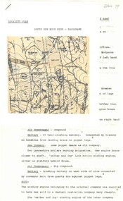
Document - ALBERT RICHARDSON COLLECTION: CENTRAL NELL GWYNNE MINE
Two-page typed document plus location map. The Central Nell Gwynne gold mine was located off Happy Valley Road, first turn to the left from Marong Road, and up on the hill. The shaft depth was 1,912 ft. The original plant had small wooden poppet legs and a steam winch which were replaced, in 1935/36 by steel poppet legs obtained from the Virginia mine at Eaglehawk. Features and history of the plant are described including the winding engine, air compressor, boilers, and crushing battery. The dividends and gold production figures are given. The total yield of gold was 61,884 oz.bendigo, mining, central nell gwynne -
 Bendigo Historical Society Inc.
Document - ALBERT RICHARDSON COLLECTION: CENTRAL RED, WHITE AND BLUE MINE
Two-page typed document plus location map. The location of the Central Red, White and Blue mine was on the north-west corner of Barnard and Honeysuckle Streets, Golden Square. The mine was formed in 1910 and ceased operations in 1936. Features of the mine are described: the winding engine, boilers, air compressor, poppet legs, engine house, crushing battery, gold produced and where obtained from. 'The rich gold yields which made this mine so prominent in its early years, was obtained from a large reef at the 318 feet level, some yields reached as high as 15 oz to the ton'.bendigo, mining, central red, white & blue mine -
 Bendigo Historical Society Inc.
Document - ALBERT RICHARDSON COLLECTION: NEW RED, WHITE AND BLUE CONSOLIDATED MINE, GOLDEN SQUARE
Two-page document plus map showing location of the New Red, White and Blue Consolidated mine on the Sheepshead Line of Reef. Information on the mine is given in the following areas: location plant, early history, its role as a leading mine, its prominence, its closure, gold production. References are provided. Document forms part of research referred to in Albert Richardson's paper 2264.70.bendigo, mining, new red white and blue mine -
 Bendigo Historical Society Inc.
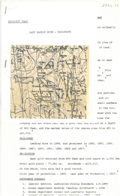
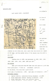
Document - ALBERT RICHARDSON COLLECTION: LADY BARKLY MINE, EAGLEHAWK
One page document, plus map, with information on the Lady Barkly Mine, New Chum line of reef, Eaglehawk. The location, early history, prominence, and gold production are described. References given on bottom of document. Document forms part of research referred to in Albert Richardson's paper 2264.70.bendigo, mining, lady barkly mine eaglehawk -
 Bendigo Historical Society Inc.
Document - ALBERT RICHARDSON COLLECTION: UNITED HUSTLERS AND REDAN MINE
Four-page typed document plus location map. The United Hustlers and Redan mine was located in the North Bendigo, Long Gully area on the Hustlers line of reef. The lease was 153 acres and included Holdsworth, Holmes, Havilah Roads and Wood Street. The Redan shaft was 1,830ft and the South or K.K. Shaft was 1,960 ft. Poppet legs steel 71 ft high. Features of the plant are described including the engine house, winding engine, air compressor, boilers, fuel, winding ropes.bendigo, mining, united hustlers and redan mine -
 Bendigo Historical Society Inc.
Document - ALBERT RICHARDSON COLLECTION: SOUTH NEW MOON MINE EAGLEHAWK
Two-page typed document with map, detailing information on the South New Moon Gold Mine on the Garden Gully line of reef. Information includes the location, depth of shaft, steel poppet legs, engine house, air compressor, battery, company ownership, battery. The shaft The 'Walker and Coy' winding engine of the later company together with poppet heads was removed later to the South Virginia company between Napier and Market Street, Eaglehawk. Gold production from both companies who owned the mine was 257,498 oz.'.bendigo, mining, south new moon gold mine -
 Surrey Hills Historical Society CollectionThe Armitstead family operated a woodyard and ice delivery business in Union Road, Surrey Hills. There are a number of photos in this collection documenting this business. The family lived nearby in Croydon Road. The site of the woodyard is now the Surrey Hills Neighbourhood Centre.
 -
 Bendigo Military Museum
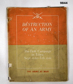
Book - LIBYA CAMPAIGN, 1940-41, The War Office, "DESTRUCTION OF AN ARMY", 1941
Information from the front cover; "DESTRUCTION/ OF AN ARMY/ The First Campaign/ in Libya/ Sept 1940 - Feb 1941/ THE ARMY AT WAR". Part of the William (Bill) THOMASON Collection. Refer Cat No. 4136P for more items.Soft cover book. Cover - heavy weight paper. White and Orange colour print on front, orange and mustard colour background. 63 pages, cut, plain, off white paper. Illustrated in sepia colours, photographs and maps. Dark brown colour ink print. Front and back end papers - contents list and photographs. Fastened with metal staples.publication, book, libya campaign, army, william (bill) thomason collection -
 Ringwood and District Historical Society
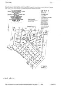
Document - Subdivision Plan, LP26914 Multiple Crown Allotments, Parish of Ringwood, County of Mornington, Vol 8021 Fol 053 - 1954
LANDATA Land Victoria plan printout dated 2010Part of Crown Allotments 1, 1A, 2, 3, 4, 5, 6, 7, 8, 9, 10, 55, 56, 57. Section C Crown Allotments 3, 12 & part of 2. Section B Map includes Bedford Road, Government Road (later Bedford Park Road then Hill Street), Marwarra Street and Tooronga Road, Ringwood. (Sheet 1 of 2 - Sheet 2 not included with collection). -
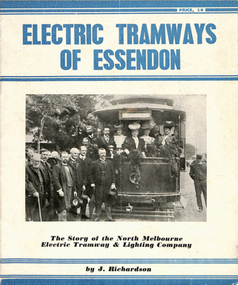 Melbourne Tram Museum
Book, Jack Richardson, "Electric Tramways of Essendon", "The Essendon Tramways", 1963
Book - 16 pages including card covers on semi gloss paper titled "The Essendon Tramways" written by Jack Richardson, published by Traction Publications, Historical Series No. 3 in 1956. The story of the North Melbourne and Electric Tramway and Lighting Company. Foreword on page 2 gives the background to the book and the persons who assisted with it. Details the historical background, a map of the tramway in 1906, relationship with the Victorian Railways, construction, rolling stock, carbarn, (depot) power station, overhead, takeover by the MMTB, connection to the City, 1956 map, expansion under the MMTB, services at the time of publication, Rolling Stock Roster, notes on some of the personnel of the tramway, junction details and dates of the various extensions etc. Includes a number of photographs, a list of railway and tramway books published by Traction Publications on the rear cover a short biography on the author. 2nd copy - from the H. S. McComb collection - stored in the original box - Items 2027 to 2030 and 1309 copy 2 contained within box 72.3 in a brown folder marked "Historical Data regarding Essendon Tramways and their services to the City" PDF copy of 1309.1 - the 1956 version added 25-2-2021 PDF copy of 1309.2 - the 1963 version added 16-3-2017. 1309.2 - 2nd edition, 1963, Historical Series No. 153, with a photo of J. Richardson on rear cover. Has notes on the edition and publisher notes. Revised to pick up errors and other photographs. Added 16-3--2017.1309.2 - has "L. W. Rogers" in ink on the top right hand corner of page 3.trams, tramways, essendon, nmetl, tramcars, depots, moonee ponds, north melbourne -
 Bendigo Historical Society Inc.
Document - MARKS COLLECTION: STRATHFIELDSAYE PLAN 1854
Plan drawn on light paper. Written on LH side of plan 'Plan of Part of the Parish of Strathfieldsaye 1854. Scale (shown) Lithographed at the Surveyor Generals Office, Melbourne July 10th. By I. Jones'. Plan shows Emu Creek and Village Reserve at top of plan, Shepherd's Creek on RH side, Parish Boundary Line on RH and bottom of plan.map, bendigo, shire of strathfieldsaye 1854 -
 Bendigo Historical Society Inc.
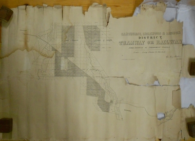
Map - MARKS COLLECTION: TRAMWAY OR RAILWAY MAP SANDHURST
... MARKS COLLECTION: TRAMWAY OR RAILWAY MAP SANDHURST...Map Marks collection railway Inglewood Original map ...Original map of 'land granted as endowment' for tramway or railway. On top Rh corner of map, in bold print 'Sandhurst, Inglewood & Loddon district Tramway or Railway. Land granted as endowment shaded, scale 60 chains to 1 inch. Lithographed by J & W. Holmes, Lith. Sandhurst'. Signed by Geo Avery Fletcher, Engineer. Map shows Parish of Leichardt, Parish of Yarraberb, Parish of Bridgwater and a section of Marong. On bottom RH corner, is small map of Sandhurst, showing railway reserve. Top LH corner, Inglewood. Map shows route of railway line from Sandhurst to Inglewood.map, marks collection, railway, inglewood -
 Bendigo Historical Society Inc.
Map - MARKS COLLECTION: CLAIM MAP SANDHURST
... MARKS COLLECTION: CLAIM MAP SANDHURST.... Written on back of map in black pen 'Maps'. Map MARKS COLLECTION ...Original hand drawn map showing lease holders along Mt. Korong Road, Sandhurst area. Names include Gold Mines Co., Hercules Co., H. Koch, Prince Alfred Co, Advance Co., J. Steane, Skeals, Abel & Co., Mounts(?) Bay co., Wellington Co., Waterloo Co., Endeavour Co., W.H. Langdon, Bridgman & Co. Written in blue pencil on top RH corner in script Syme Well, Nova Ste (indecipherable), German Aleno Co., Concord, Rae. Written on back of map in black pen 'Maps'.map, bendigo, mining leases -
 Bendigo Historical Society Inc.
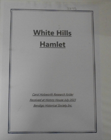
Document - RESEARCH FOLDER COLLECTION: WHITE HILLS HAMLET, 1990 - 2015
... rolls, local directories, and rates records Maps Document ...Folder of research material compiled by Carol Holsworth. Received at History House in July 2023. White Hills Hamlet Includes Newspaper articles including many photographs of properties in the White Hills area advertised for sale Historical information about White Hills Hamlet properties Family history information about former residents of the White Hills area Notes based on electoral rolls, local directories, and rates records MapsCarol Holsworthbendigo, history, white hills hamlet -
 Bendigo Military Museum
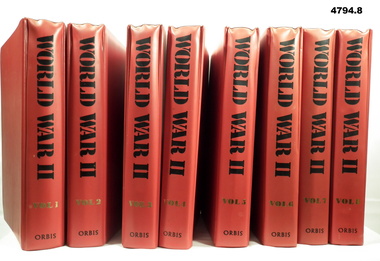
Magazine - BINDERS, CONTAINING MAGAZINE COLLECTION, ORBAS Publishing Ltd, World War ll, Unknown
Eight binders containing a magazine collection. Binder - cardboard with red coloured plastic over cardboard - metal fastening system. Black and gold print on spine. Magazines - 3360 pages in total, plain white paper, illustrated black and white and colour photos and maps. Vol 1 - pages 1 to 420. Vol 2 - pages 421 to 840. Vol 3 - pages 841 to 1260. Vol 4 - pages 1261 to 1680. Vol 5 - pages 1681 to 2100. Vol 6 - pages 2101 to 2520. Vol 7 - pages 2521 to 2940. Vol 8 - pages 2941 to 3360. Index to all binders at back Vol 8.magazines, ww11, military -
 Clunes Museum
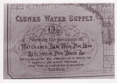
Document - MAP
CLUNES WATER SHED SUPPLY MAP SHEWING THE POSITION OF WATERSHED ECT. FOR THE COLLECTION AND DISTRIBUTION OF WATER FOR DOMESTIC AND MINING PURPOSES TO THE TOWN OF & GOLDMINES IN AND AROUND CLUNES.PHOTOCOPY SECTION OF PHOTOGRAPH AND PLAQUE AND MAP OF CLUNES WATER SUPPLY. SHOWING THE POSITION OF WATERSHED, DAM, WEIR PIPEHEAD RESERVOIR PIPE TRACK.SEE PHOTOGRAPH ON BACK OF HISTORY OF OBJECT.local history, photographs, water supply -
 Bendigo Military Museum
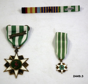
Award - SERVICE RIBBON, MEDALS VIETNAM, Post 1965
Items in collection of Murray Stanley Metherall. Refer Cat No 590.2 for his service details..1) Service Ribbons - Vietnam Campaign, National Medal Ribbon with clasp, South Vietnam Ribbon has silver coloured clasp '60'. .2) South Vietnamese Campaign Medal. Green & white striped ribbon. Medal brass coloured 6 pointed star mounted with white enamel 6 pointed star & green enamel circular centre with enamel map of South Vietnam. Brass coloured clasp '1960' attached to ribbon. .3) Minature of .2) without the clasp..2) & .3) On back of medal: “CHIEU-DICH, VIETNAM, BOI-TINH”vietnam, medals, ribbons, campaign -
 Bendigo Military Museum
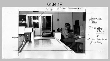
Photograph - AUTOMAP 1 Production – Army Survey Regiment, Fortuna, Bendigo, c1978-1980
This collection of 20 photos was most likely taken in c1978. The AUTOMAP 1 computer assisted cartography and mapping system was introduced in 1975. The components of AUTOMAP 1 were the Input Sub-System of four Wild B8s stereoplotters and three Gradicon digitising tables, the Optical Line Following Sub-System – Gerber OLF, the Verification Sub-System – Gerber 1442 drum plotter, the General Purpose Sub-system – HP21MX computer and the Output Sub-System – Gerber 1232 flatbed plotter). The first map was published in 1978 (Strickland 3665-3, 1:50,000). AUTOMAP 1 was the first computer assisted cartography and mapping system utilised by the Survey Corps and was the first system used by Australian mapping organisations. The history of the AUTOMAP 1 system is covered in more detail with additional historic photographs, in pages 116-118 of Valerie Lovejoy’s book 'Mapmakers of Fortuna – A history of the Army Survey Regiment’ ISBN: 0-646-42120-4. See items 6122.20P, 6410.24P, 6183.19P, 6200.5P, and 6222.17P for additional photographs of the AUTOMAP 1 system.This is a set of 20 photographs of Air Survey Squadron military and civilian personnel operating AUTOMAP 1 equipment at the Army Survey Regiment at Fortuna, Bendigo, c1978-1980. Black and white photos .1P to .18P are on photographic paper and were scanned at 300 dpi. Photo .4P is in colour and mounted with a duplicate on manilla card. Black and white photos .19P to .20P are on 35mm negative film and scanned at 96 dpi.They are part of the Army Survey Regiment’s Collection. .1) - Photo, black & white, c1978-1980, Gerber Optical Line Follower (OLF), SSGT John Bennett. .2) - Photo, black & white, c1978-1980, HP21MX computer General Purpose Sub-system. .3) - Photo, black & white, c1978-1980, Gerber OLF .4) - Photo, colour, c1978-1980, unidentified digitising on Gradicon edit table. .5) - Photo, black & white, c1978-1980, Gerber verification drum plotter. .6) - Photo, black & white, c1978-1980, Gerber OLF, CAPT Rob Bridge. .7) - Photo, black & white, c1978-1980, Programming and system administration, SGT Alan Toogood. .8) - Photo, black & white, c1978-1980, Unidentified digitising on Gradicon edit table. .9) - Photo, black & white, c1978-1980, CPL Rick Downie digitising on Gradicon edit table. .10) - Photo, black & white, c1978-1980, SPR Dave Irving digitising on Gradicon edit table. .11) - Photo, black & white, c1978-1980, Gerber OLF and CPL Rick Downie. .12) - Photo, black & white, c1978-1980, 1130 Computer System administration, L to R: unidentified, SSGT Les Dixon, SPR Geoff Havelberg. .13) - Photo, black & white, c1978-1980, AUTOMAP 1 tape administration, Maryanne De Groot. .14) - Photo, black & white, c1978-1980, AUTOMAP 1 tape drive. .15) - Photo, black & white, c1978-1980, HP21MX computer General Purpose Sub-system. .16) - Photo, black & white, c1978-1980, digitising topographic features with a Wild B8 stereo plotter, L to R: unidentified, CPL John Smith. .17) - Photo, black & white, c1978-1980, digitising topographic features with a Wild B8 stereo plotter, CPL John Smith. .18) - Photo, black & white, c1978-1980, digitising topographic features with a Wild B8 stereo plotter, CPL Adrian Rynberk. .19) - Photo, black & white, c1978-1980, Programming and system administration, SGT Alan Toogood. .20) - Photo, black & white, c1978-1980, Gerber OLF, CPL Chris Edwards. .1P to .20P - No personnel are identified.royal australian survey corps, rasvy, army survey regiment, army svy regt, fortuna, asr, automap 1 -
 Bendigo Military Museum
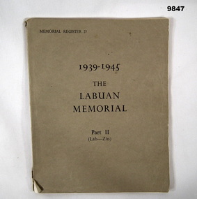
Book - MEMORIAL REGISTER, 1939-45, Order of The Imperial War Graves Commission, "1939-1945 THE LABUAN MEMORIAL PART11 (LAB-2IN)", 1958
Information from title page: "THE WAR DEAD OF/ THE BRITISH COMMONWEALTH/ AND EMPIRE/ The Register of the Names of those who fell/ in the 1939-1945 War and have no/ known grave./THE LABUAN MEMORIAL/ PART 11/ (Lab-2in)" Part of the William (Bill) THOMASON Collection. Refer Cat. No. 4136P for more items.Soft cover book; Cover - light brown colour cardboard. Black colour ink print on front., 130 pages, cut, plain, off white colour paper. Register names have been listed alphabetically. Illustrated black and white photographs and a map.publications, books, memorial register, ww2, william (bill) thomason collection -
 Bendigo Military Museum
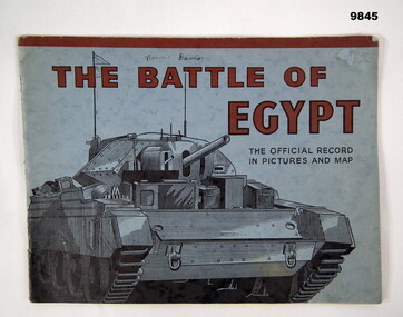
Book - PICTORIAL, WW2, WAR OFFICE, "THE BATTLE OF EGYPT", 1942
Information from the front cover; "THE BATTLE OF/ EGYPT/ THE OFFICIAL RECORD/ IN PICTURES AND MAP" Part of the William (Bill) THOMASON Collection. Refer Cat. No. 4136P for more items.Soft cover book. Cover - blue colour cardboard, red and black colour print on front and back. Front illustration - black ink sketch of a tank. 35 pages - cut, plain, off white colour paper. Pictorial book with black and white photographs and map. Fastened with metal staples. Front cover - handwritten owner's information.Handwritten owner's information - black ink pen, "Norma Davis".publications, books, egypt, ww2, william (bill) thomason collection -
 Bendigo Military Museum
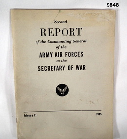
Book - REPORT, ARMY AIR FORCES, USA, Superintendent of Documents, U.S. Government Printing Office, SECOND REPORT OF THE COMMANDING GENERAL OF THE ARMY AIR FORCES TO THE SECRETARY OF WAR, 1945
From the Foreword: "It is once more the obligation of the AAF to submit a report of its/ activities to the American people". WW11. Part of the William (Bill) THOMASON Collection.' Refer Cat. No. 4136P for more items.Soft cover book: Cover - light grey colour cardboard with black ink print on front. 93 pages, cut, plain, gloss white colour paper. illustrated black and white photographs, posters and maps.publications, "books, army air forces, usa, ww2, william (bill) thomason collection -
 Bendigo Military Museum
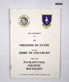
Programme - 1991 PROGRAMME, The Conferring of the Freedom of Entry to the Shire of Goulburn upon the Puckapunyal Logistics Battalion, 19 Oct 1991
Parade took place in Nagambie on Saturday 19th October 1991. Part of the Cooper Collection.A5 sized, printed booklet with text in black type. Twelve pages with black and white illustrations and photographs. Pages secured with two staples. Front cover has title in black type. Shire of Goulburn crest and Puckapunyal Logistics Battalion Insignia in colour at top of front cover. Map of Nagambie on back cover.cooper collection, puckapunyal, logistics, freedom of entry