Showing 11175 items matching "planning "
-
 University of Melbourne, Burnley Campus Archives
Plan, S. Soerono, Project Xerophytic Garden, 1989
Planting Plan and Coloured Elevation from Pt A to A₁ by S. Soerono, dated 10.11.1989s. soerono, landscape design, xerophytic gardens -
University of Melbourne, Burnley Campus Archives
Plan - Planting plan, 1993
Tracing paper plan by Lisa McKern, dated 11.11.1993. Scale 1:100.lisa mckern, planting plan -
University of Melbourne, Burnley Campus Archives
Plan (Item) - Coloured plan, laminated, Sewerage & Water Plan
-
University of Melbourne, Burnley Campus Archives
Plan - Planting Design, Cul-de-sac Planting Design, Nov 2020
john rayner, garden plan, plant list -
 University of Melbourne, Burnley Campus Archives
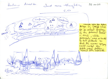
Plan, Perennial Border
perennial border, geoff olive, andrew smith, potato weed -
University of Melbourne, Burnley Campus Archives
Plan (item) - Plans, V.C.A.H Nursery Complex
Fire Protection approval and legend stamped in red -
Tarnagulla History Archive
Research file: Planning Records for Bicentennial Celebrations, Bicentennial, 1988
Donald Clark Collection A red binder containing planning records for Australia's Bicentennial celebrations held in Tarnagulla. tarnagulla, bicentennial, community celebrations, commemorations -
 Melbourne Legacy
Document, Annual ANZAC Commemoration preparations 1989, 1989
Details of discussions of the annual Anzac Commemoration Ceremony for Students with the Department of Education in 1989 regarding the 1990 ceremony. The ceremony provides a valuable opportunity for students to gain an appreciation of the Anzac spirit, the significance of the Shrine and the meaning of Anzac Day.A record of planning undertaken for the annual ceremony at the Shrine for school students by the Commemoration committee. Also that it was part of an original archive set up with S17 being document number 17 in the 'Shrine' archive.Minutes of a meeting and memo regarding planning for the Annual Anzac Commemoration Service for Students.Handwritten in blue pen 'TV coverage / S17'anzac commemoration for students, wreath laying ceremony -
 Bendigo Historical Society Inc.
Map - KANGAROO FLAT ?, Circa 1880
Map: Parish plan showing area from Kangaroo Flat to Spring Gullymap, bendigo, parish plan, kangaroo flat, spring gully -
Glenelg Shire Council Cultural Collection
Plan - Port of Portland Authority Marine Department Depot Site Layout and Groundworks, 29/09/1988
port of portland, port of portland authority archives, plans -
 Melbourne Tram Museum
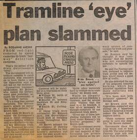
Newspaper, Herald Sun, "Tramline 'eye' plan slammed", 5-4-1989
Provides information about a proposal "speed camera" style camera for use in Fairways to detect motorists who should have not have been using the lane. Proposed by the Minister for Transport Jim Kennan, opposed by the Opposition Transport spokesman Alan Brown. Gave some proposed locations. Article written by Rosanne Michie. Yields information about a proposal to monitor compliance of Fairways,Newspaper clipping - "Tramline 'eye' plan slammed" - The Sun 5-4-1989tramways, trams, melbourne, public transport, fairways -
University of Melbourne, Burnley Campus Archives
Plan, Landscape Design - option 2, 1988
Drawing 2/2. Dated August 1988. Landscape plan of unnamed propertylandscape design -
 Port Melbourne Historical & Preservation Society
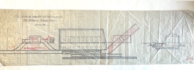
Plan - Suggested Alterations, Port Melbourne Pumping Station, Engineering Department, City of Port Melbourne
Plan showing suggested alterations to Port Melbourne Pumping Station, date unknown.engineering - canals and drainage, sandridge lagoon -
Bendigo Historical Society Inc.
Map - BENDIGO PARISH PLAN
BHS CollectionBendigo Parish Plan Section C Paper with edges bound with canvas tape.bendigo, land sales, parish map -
Lakes Entrance Historical Society
Book, Streeter Neil and Battista Marlene, East Gippsland Rail Trail Concept Plan, 1987c
Concept plan for establishment of rail trail on disused railway reserve Bairnsdale to Orbost.recreation -
Lakes Entrance Historical Society
Book, Parks Victoria Compiler, MacLeod Morass & Jones Bay Draft Management Plan 2003, 2003
A draft plan for the startegies to manage the Macleod Morass and Jones Bay Wildlife reservesenvironment, fauna, natural resources, restoration, vegetation -
Lakes Entrance Historical Society
Book, DCNR, Forest Management Plan 1995, 1995
A plan providing guidelines for the balanced use of state forests in East Gippsland Victoriaforest, conservation -
 Phillip Island and District Historical Society Inc.
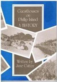
Book - Book, softcover, Guesthouses on Phillip Island : a history, 1987
Historical169 p. : ill., facsims., maps, plans ; 25 cm. ISBN 0731600088 phillip island, accomodation, guesthouses, history, housing, julie cutter, 1987, broadwater guesthouse cowes phillip island, carisbrooke guesthouse cowes phillip island, bayview house, osbourne park guesthouse phillip island, erehwon guesthouse, isle of wight hotel -
 Bendigo Historical Society Inc.
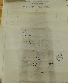
Map - VICTORIA HILL AREA
Contour plan of the Victoria Hill area, with all of the historical features marked and namedCompiled by AHQ Survey Regt. CMF increment May 1971map, reserves, mining, bendigo goldfield, victoria hill -
 Whitehorse Historical Society Inc.
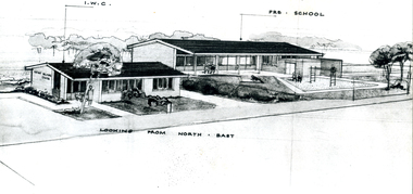
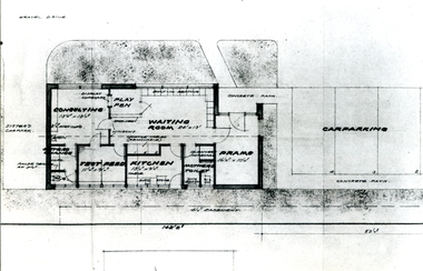
Photograph - B/W Photograph, East Burwood Infant Centre
Black and white photo of East Burwood Infant Centre and Pre-School -planeast burwood infant welfare centre, east burwood preschool, plans -
 Whitehorse Historical Society Inc.
Photograph, East Burwood Infant Welfare Centre
Black and white photo of floor plan for East Burwood Infant Welfare Centreeast burwood infant welfare centre, floor plan -
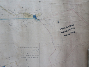 Federation University Historical Collection
Plan, Creswick Water Supply from Bullarook to Creswick, 02/10/1869
Probably gazetted on 12 April 1872 (pg 737)Large horizontal paper plan glued in three sections to a linen backing. Coloured plan shows pipe and rack track from the Bullarook Reservoir to Albert Street, Creswick. Attached with ribbon top left are twelve pages giving bearing and lengths / descriptions of pipe and rack track. Five information boxes drawn along the bottom of plan gives extra information where pipe passes through private properties. Main heading 'Plan of Creswick Water Supply / scale eight chains to an inch / County of Talbot / Parish of Creswick'. Calculations and hand written notes in ink and pencil also on plan. Verso 'Dean Reservoir'. Signed and dated.creswick, water supply, bullurook reservoir, dean, bush inn, hesken, rivers, warner, taylor, gillard, mccormack, mcdonald, brown, naples, humbug hill sluicing co, frank rivers, w.r. taylor, j. and m. mccormack, j. mcdonald, richard brown, c. naples -
 University of Melbourne, Burnley Campus Archives
Plan, Herbaceous Border, 1984-1997
(1) Summer Autumn Herbaceous Border VCAH 1984 - Plant Plan. (2) 2 tracing paper copies The Herbaceous Border VCAH Burnley 6.7.87, names of plants around it. (3) Tracing paper copy, The Herbaceous Border Planting Schedule 12.8.87 and 1 paper copy with annotations in pencil. (4) Planting Plan, 1 with "1991" written on it, and several sketches and copies. (5) Coloured plan, names of some plants different to (4). (6) Coloured plan with some differences to (5). Dated 1997.herbaceous border, burnley vcah, garden beds -
 Warrnambool and District Historical Society Inc.
Subdivision plan, Part of Preston Estate Parish of Wappan
This map possibly relates to land of John Bostock at Preston, Delatite. Part of a collection of papers relating to the Bostock family one of the earliest pioneering families in Warrnambool.Cream coloured map printed in black with sections coloured in pink. Plan of subdivision of part of crown allotments 15 and 17 and part of Preston pre- emptive right, Parish of Wappan, County of Delatite.warrnambool,bostock,augustus bostock map, delatite map,district of wappan map, -
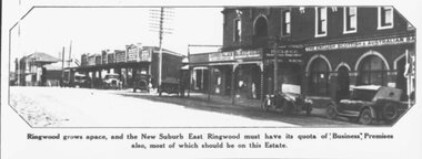 Ringwood and District Historical Society
Photograph, 1925 - Ringwood East Railway Station Estate. Photo taken from subdivisional plan land sale
Catalogue card reads, "1925 - Ringwood East Railway Station Estate. Photo taken from subdivisional plan land sale." -
Clunes Museum
Drawing, ALF LOWTHER, CRUSHING WORKS PORT PHILLIP COMPANY, UNKNOWN
PHOTOCOPY OF A DRAWING OF THE CRUSHING WORKS OF THE PORT PHILLIP COMPANY, CLUNESON REVERSE: HANDWRITTEN ON REVERSE OF PLAND "PORT PHILLIP MINE, PHOTOCOPY OF DRAWINS ALF LOWTHER BENDIGO" PRINTED ON FRONT PLAN L812port phillip mine, plans, crushing works -
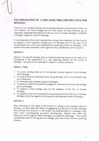 Bendigo Historical Society Inc.
Document - VERN ROBSON COLLECTION: LONG TERM STRATEGY PLAN FOR BENDIGO
A4 document: 14 pages. document outlines long term strategy plan proposal, to feed into 2020 plan. Meeting between Commissioner Crofts, Mr. Vern Robson, Mr. Trevor Budge and Mr Evan Jones.bendigo, council, plan for strategy plan -
Bendigo Historical Society Inc.
Map - CAMPBELL COLLECTION: BENDIGO & DISTRICT MAPS, 14-6-29
Map. Eppalock, Sedgwick and Strathfieldsaye. Scale 20 chains to 1 inch. Total area 3972 acres. Prepared in W.P.B. from Assessment Plan and Parish Plans. H.A. Darby. (number 378 in map cupboard 1)H.A.Darbymap, bendigo, agricultural lands -
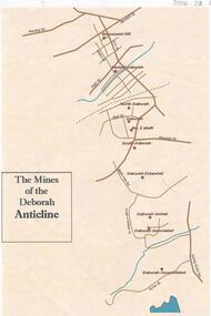 Bendigo Historical Society Inc.
Document - THE MINES OF THE DEBORAH ANTICLINE
Plan of the mines along the Deborah Anticline: Deborah Consolidated, Deborah Associated, Deborah United, Deborah Extended, South Deborah, No. 2 shaft, Deborah North Deborah, Central Deborah, Monument Hill are all sited on the plan.Philip Wilkin, volunteer, BHSbendigo, mining, deborah line of reef -
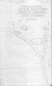 Bendigo Historical Society Inc.
Photograph - DIAMOND HILL 1936, PLAN OF OCCUPATION
Print of 'Application of J. Hattam, plan of occupation parish of Sandhurst, County of Bendigo' Plan shows Post Office site, large dam, 'formerly cultivated site near Post Office'. A un-named gully is marked.bendigo, mining, diamond hill