Showing 10388 items
matching plan
-
 Bendigo Historical Society Inc.
Document - MARKS COLLECTION: PLAN OF SANDHURST CITY CENTRE AND SURROUNDING AREA ( NO. 2 )
Plan drawn on heavy parchment. Written on plan Sandhurst Sheet No. 2. (See record 8300.58 for continuation of plan into city centre) Plan shows allotments with owner names, where applicable. Quartz crushing machines marked. On bottom lithographed at the Department of Lands and Survey, Melbourne, by D. Henerson, March 12th., 1867.bendigo, planning, sandhurst -
 Kew Historical Society Inc
Plan - Subdivision Plan, J R Mathers & McMillan, Clutha Subdivision, 1940
Pru Sanderson, in her groundbreaking ‘City of Kew Urban Conservation Study : Volume 2 - Development History’ (1988), summarised the periods of urban development and subdivisions of land in Kew. The periods that she identified included 1845-1880, 1880-1893, 1893-1921, 1921-1933, 1933-1943, and Post-War Development. These periods were selected as they represented periods of rapid growth or decline in urban development. An obvious starting point for Sanderson’s groupings involved population growth and the associated economic cycles. These cycles also highlighted urban expansion onto land that was predominantly rural, although in other cases it represented the decline and breakup of large estates. A number of the plans in the Kew Historical Society’s collection can also be found in other collections, such as those of the State Library of Victoria and the Boroondara Library Service. A number are however unique to the collection.The Kew Historical Society collection includes almost 100 subdivision plans pertaining to suburbs of the City of Melbourne. Most of these are of Kew, Kew East or Studley Park, although a smaller number are plans of Camberwell, Deepdene, Balwyn and Hawthorn. It is believed that the majority of the plans were gifted to the Society by persons connected with the real estate firm - J. R. Mathers and McMillan, 136 Cotham Road, Kew. The Plans in the collection are rarely in pristine form, being working plans on which the agent would write notes and record lots sold and the prices of these. The subdivision plans are historically significant examples of the growth of urban Melbourne from the beginning of the 20th Century up until the 1980s. A number of the plans are double-sided and often include a photograph on the reverse. A number of the latter are by noted photographers such as J.E. Barnes.The subdivision plan for the Clutha Subdivision is one of the largest in the Society’s collection. The plan includes a map of the proposed allotments, photographic views to the north and south, and information about the kinds of buildings that could be constructed on the allotments. The subdivision was bounded by Studley Park Road, and Carson, Stevenson and Edgecombe Streets. Two new streets, Mackie Court and Younger Street were created as part of the subdivision. The subdivision took its name from ‘Clutha’, the home of John Carson, who was to become Mayor of Kew in 1863. A Report to the City of Boroondara outlined how: ‘The Clutha estate was progressively developed from 1940, with new houses under construction on the Studley Park Road, Carson and Edgecombe Street frontages by 1941. By 1943, directory listings were available for all addresses with the exception of Mackie Court. Building ceased after the government’s prohibition on civilian building was enforced from 1942, with little change in listings until the 1950s when the remainder of the subdivision was developed’."H"subdivisions - kew - studley park, clutha subdivision, studley park road -
Whitehorse Historical Society Inc.
Map, Schwerkolt historical homestead, 10/04/2002 12:00:00 AM
Plans of Schwerkolt Cottage and Museum Complex.Plans of Schwerkolt Cottage and Museum Complex. Consists of master plan, details and site analysis, and accompanying letter, scale 1:500.Plans of Schwerkolt Cottage and Museum Complex. schwerkolt cottage & museum complex., plans -
 Kew Historical Society Inc
Book, Helen Baker, Hyde Park Barracks, 1965
Sydney : Angus and Robertson in association with the State Planning Authority of N.S.W., 1965 48 p. : ill., map, plans ; 25 cm. non-fictionsydney (n.s.w.) -- historic buildings -
University of Melbourne, Burnley Campus Archives
Plan, Burnley Gardens. City of Richmond. Parish of Jika Jika - County of Bourke, 1927
Plan showing Burnley Gardens - bounded by Swan St to N, Yarra River to E, Richmond Park on S and W side. Photo-lithographed at Dept of Lands & Survey by W.J. Butson. Plan shows old orchard, fowl sheds, coops and yards, milking shed, silo,nursery, glasshouse, fattening pens, gardens and orchards area in S.W. corner.burnley gardens, orchards, sheds, nursery -
University of Melbourne, Burnley Campus Archives
Plan, Swan St. Entrance, 1988-1989
Found in file labelled, "Swan St. Entrance" Geoff Olive.(1) Correspondence between Mr Ron Hamilton, Manager, Tram Operations, Eastern Section and Steve Mullany, Lecturer. Includes plan of "Entrance to V.C.A.H. Burnley and Plant Research Institute." (2) Handwritten note dated 5 July 89. (3) Handwritten estimate of costs by Ian W(instone). (4) Photocopy of planting plan. Also see B11.0592. ron hamilton, vcah, burnley campus, steve mullany -
 City of Kingston
Pamphlet - Colour, Roy Dunn Pty. Ltd, Central Corner Estate Moorabbin and Highett, c. 1923
Sales plan for land in the suburbs of Highett and Moorabbin, bordered by Point Nepean Road and Wickham Road East incorporating William StreetThe developing urban area of Highett and Moorabbin within the City of Kingston. This land sale pamphlet illustrates the subdivision of land within the municipality and the changing demographic of the district as new houses are constructed close to infrastructure.Colour pamphlet advertising for private sale land in the Central Corner Estate in Moorabbin and Highett. Incorporates a map of the estate bordered by Point Nepean Road and Wickham Road East, with subdivisions also available on both sides of William Street. Handwritten in blue pencil on subdivision plan: a tick is drawn on subdivisions 2-18 Handwritten in blue pencil on subdivision 6: a box with an x inside Handwritten in blue pencil on subdivisions 10 and 12: S Handwritten in black ink on front page: [indecipherable] / McKittricks Handwritten in grey pencil on rear page: McKilhick / Nepean Rd Handwritten in grey pencil on rear page upside down: 160000 / 15 8300 [crossed out] land sales, estate, highett, moorabbin -
 Bendigo Historical Society Inc.
Map - Marong County of Bendigo
Map of Marong. Drawn and reproduced at the Dept. of Lands and Survey, Melbourne. By authority: W.M. Houston Government Printer. June 1953.On the back in blue pen: certified plan parish Marong, signed minister and seal affixed for land S sec.72 evidence act. I certify that this a true plan parish Marong (signature illegible) minister for lands.map, marong -
 Warrnambool and District Historical Society Inc.
Ledger, Letter book 1892-1904, 1892
This letter book has letters, sketch maps and plans and dates from 1892 to 1904. It came from the office of John William Crawley, Junior, an engineer, architect and surveyor in private practice in Warrnambool and also the engineer of the Shire of Warrnambool from 1895 to 1935. His father, brother and son were also engineers and worked in that capacity or as the Shire Secretary for the Shire of Warrnambool, with the Crawley family recording a total of 132 years of service to the Shire. This letter book was passed on to John Crawley’s son, Rolf Crawley, Engineer for the Shire of Warrnambool from 1935 to 1968. The letter book then came into the possession of Michael Hand who took over the private surveying business of Rolf Crawley in Warrnambool. The Warrnambool and District Historical Society has acquired the letter book, one of several Crawley ledgers, from the Michael Hand estate. This letter book is of considerable significance as it contains maps, plans, sketches and written information which is the work of John William Crawley Junior, the engineer for the Shire of Warrnambool for 40 years. It will be very useful to researchers. This is a hard cover letter book of 500 pages. The cover is black with leather binding on the edges of the cover and on the spine. The pages contain an alphabetical listing of the letters, handwritten letters and many sketch maps and plans. There are several loose pages of plans and diagrams at the back of the book. The inside of the covers has a blue mottled pattern. The edges of the cover are torn. There is a mauve stamp on the first page. ‘Letter Book 1892 to 1901’ ‘Rolf L. Crawley, Civil Engineer, Drainage and Water Supply Engineer, Licensed Surveyor, Registered Architect, Warrnambool’ john william crawley, junior, warrnambool, rolf crawley, warrnambool, shire of warrnambool -
 Greensborough Historical Society
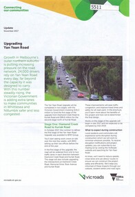
Pamphlet, Upgrading Yan Yean Road, 2017_11
VicRoads let a contract for the upgrade of Yan Yean Road between Diamond Creek Road and Kurrak Road in October 20174p. text and col. photographs and plan.yan yean road -
 City of Moorabbin Historical Society (Operating the Box Cottage Museum)
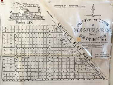
Document, photocopy of Plan of Beaumaris 1853, c1960
Beaumaris includes two early estates in the parish of Moorabbin developed by Josiah Holloway from 1852. Named Beaumaris Town and Beaumaris Estate (after the pastoral run in the area and ultimately after Beaumaris in Wales), the lots comprising them were marketed by Mr Holloway's suggesting that the railway was imminent and a canal would be built. The township developed slowly, a Post Office opened on 1 March 1868, but was replaced next month by Gipsy Village office (now Sandringham) In 1862 Beaumaris was one of the early settler communities within the boundaries of the Moorabbin District Roads Board , the region’s first local government authority. Beaumaris is a suburb in Melbourne, Victoria, Australia, 19 km south-east from Melbourne's central business district. .Since the Amalgamation of Councils 1994 the local government area is the City of Bayside which includes Brighton. A Photocopy of the Plan of Beaumaris 1853 A3moorabbin, county of bourke, brighton, beaumaris, pioneers, early settlers. market gardeners, cheltenham, king. john, holloway josiah, whorral charles, arthur’s seat road, nepean highway, morabbin district roads board, sandringham, mordialloc, mentone -
 Federation University Historical Collection
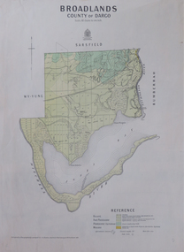
Map, Broadlands, County of Dargo, 1887
Plan of Broadlands, County of Dargo, Victoria.broadford, j.g. easton, dargo, geological -
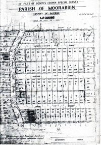 City of Moorabbin Historical Society (Operating the Box Cottage Museum)
Flyer - Garfield Estate, Ormond
At the end of World War One, there was a renewed interest in residential land and a number of estates opened up in the Municipality of Moorabbin.Example of the progress of the Municipality of MoorabbinPhotocopy of the plan of the Garfield Estate, OrmondPart f Dendy's Crown Special Survey - parish of Moorabbin - County of Bourke - Garfield Estatedraper street, lord street, hudson street, blackshaw street, tucker road, ormond, mckinnon, real estate -
 City of Moorabbin Historical Society (Operating the Box Cottage Museum)
Book, Colorgravure Publications [for] The Herald & the Sun news-pictorial, Queen Elizabeth's coronation book, 1953?
"This book is right royally produced to be a treasured exhibit in the library of every home. Seven separate distinct printing operations have gone to make the beautiful, vivid coloring which distinguishes it as an object of fine and lasting craftsmanship. No pains have been spared to produce a fitting volume to mark the beginning of the Age of Queen Elizabeth the Second, and the publishers proudly present it as a book which their readers will rejoice to own."--Front flap.[48] pages : colour illustrations, plans ;non-fiction"This book is right royally produced to be a treasured exhibit in the library of every home. Seven separate distinct printing operations have gone to make the beautiful, vivid coloring which distinguishes it as an object of fine and lasting craftsmanship. No pains have been spared to produce a fitting volume to mark the beginning of the Age of Queen Elizabeth the Second, and the publishers proudly present it as a book which their readers will rejoice to own."--Front flap.queen elizabeth ii, coronation -
Bendigo Historical Society Inc.
Map - BENDIGO PARISH PLAN
Bendigo Parish Plan Section Kbendigo, land sales, parish map -
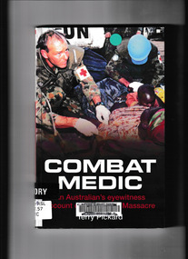 Monbulk RSL Sub Branch
Book, Big Sky Publishing, Combat medic : an eyewitness account of the Kibeho massacre, 2008
On the 22nd of April 1995 more than 4,000 Rwandans were massacred and thousands more injured in a place called Kibeho. Terry Pickard, a seasoned soldier and medic, was one of a 32-strong force of Australian UN peacekeepers in Kibeho on that terrible Saturday. While the United Nations’ presence prevented the death toll from being even worse than it was, the massacre continues to haunt him. The rules of engagement that stopped him from intervening in the senseless slaughter, and the life and death decisions he was forced to make when dealing with the injured condemned him to more than a decade of recurring nightmares and debilitating flashbacks. The horror and unimaginable tragedy of the Kibeho Massacre still looms large in the lives of Rwandans and the people sent to help the African country. No one who walked away from that day was ever the same again. Combat Medic is a personal account of one Australian soldier who found himself at the centre of events that shocked the world, and the personal toll that he paid. Terry Pickard’s army career spanned nearly 20 years. More than 25 years after Rwanda he continues to struggle with post traumatic stress triggered by his experiences. Collapse summaryIll, maps, plans, p.181.non-fictionOn the 22nd of April 1995 more than 4,000 Rwandans were massacred and thousands more injured in a place called Kibeho. Terry Pickard, a seasoned soldier and medic, was one of a 32-strong force of Australian UN peacekeepers in Kibeho on that terrible Saturday. While the United Nations’ presence prevented the death toll from being even worse than it was, the massacre continues to haunt him. The rules of engagement that stopped him from intervening in the senseless slaughter, and the life and death decisions he was forced to make when dealing with the injured condemned him to more than a decade of recurring nightmares and debilitating flashbacks. The horror and unimaginable tragedy of the Kibeho Massacre still looms large in the lives of Rwandans and the people sent to help the African country. No one who walked away from that day was ever the same again. Combat Medic is a personal account of one Australian soldier who found himself at the centre of events that shocked the world, and the personal toll that he paid. Terry Pickard’s army career spanned nearly 20 years. More than 25 years after Rwanda he continues to struggle with post traumatic stress triggered by his experiences. Collapse summary united nations - peacekeeping forces - rwanda, rwanda - civil war - atrocities -
Bendigo Historical Society Inc.
Map - REDCASTLE AND DARGILE, No date visible
Map: Redcastle and Dargile. Parish planmap, parish plan, redcastle, dargile -
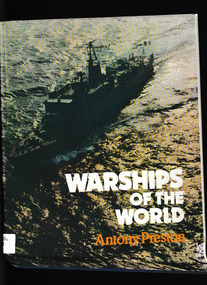 Monbulk RSL Sub Branch
Book, Jane's Publishing Company, Warships of the world, 1980
A description of various warships listed by categoryIndex, ill, plans, p.224.non-fictionA description of various warships listed by categorywarships - history, warships - development -
University of Melbourne, Burnley Campus Archives
Document, Graduate Destination Survey 2003, 2004
University of Melbourne, University Planning Officegraduates, survey, 2003, university of melbourne -
University of Melbourne, Burnley Campus Archives
Document, VCAH Dookie Centennial Steering Committee, 1984-1985
Initial planning proposal, minutes, etc.vcah, dookie, centennial -
Stawell Historical Society Inc
Archive - Books & Papers, The Australian Sketcher Article Stawell and the Pleasant Creek reefs July 12 1873, July 12 1873
Article printed after legislation arising out of 'Jumped Claims' back in history of Pleasant Creek - alluvial and quartz mining Currant mining operationsPhotocopy of article with lithographs and plan of Stawell -
Whitehorse Historical Society Inc.
Pamphlet, Our Vision for Whitehorse 2006-2016, 2006
Forward planning statement of the City of Whitehorse.Forward planning statement of the City of Whitehorse.Forward planning statement of the City of Whitehorse.city of whitehorse, planning -
Whitehorse Historical Society Inc.
Pamphlet, Our Vision for Whitehorse 2012
Forward planning statement of the City of Whitehorse.Forward planning statement of the City of Whitehorse.Forward planning statement of the City of Whitehorse.city of whitehorse, forward planning -
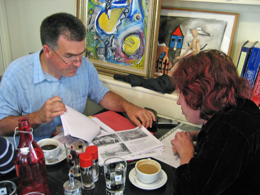 Ballarat Heritage Services
digital photographs, Lisa Gervasoni, planning exhibition, c2006
Gary Lawrence and Clare Gervasoni planningheritage, clare gervasoni, gary lawrence, wine water and stone exhbition, red star cafe, swiss italian -
Glenelg Shire Council Cultural Collection
Plan - Plans / Line Drawings - Portland Harbour Trust Commissioners slipway and canal area plan with slipway, Victoria, Jun-80
Front: '4' black texta, top right corner -
Clunes Museum
Plan - FLOOR PLAN, R. ANDREW BROWNELL, JANUARY 2006
FLOOR PLAN AND ELEVATIONS OF CLUNES MUSEUM PRIOR TO RENOVATION. MEASURED DRAWING SCALE 1:100. R. ANDREW BROWNELL, ARCHITECT DAYLESFORD. LAMINATED.clunes museum, floor plans, william barkell mem. arts & historic centre -
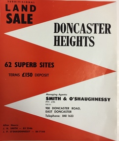 Kew Historical Society Inc
Plan - Subdivision Plan, Doncaster Heights
Real estate brochure produced for Smith & O'Shaughnessy of 900 Doncaster Road for the sale of the '65 superb sites' in the Doncaster Heights Estate. Streets with lots for sale include: Church Road, Norfolk Circuit, and Hampshire Road.Historic subdivision planFour-page colour real estate brochure issued for the sale of the Doncaster Heights Estate. The inside pages include a street plan with the numbered lots.subdivision plans - doncaster, doncaster heights estate -
University of Melbourne, Burnley Campus Archives
Plan, Detail Survey of Willsmere Park, 1978-c.1987
Plan dated 27.10.1978 for Swinburne College of Technology Ltd. With updated handwritten notes post 1987 by T.Smith, B. Jones, B.S. Ooi, D.Ong.swinburne college of technology, willsmere park, t.smith, b. jones, b.s. ooi, d.ong -
University of Melbourne, Burnley Campus Archives
Plan, Richmond, 2001
Handdrawn plan of Burnley Campus and the surrounding Richmond area. Probably drawn by a student for Burnley Student Association. Found in former Staff Room 2012."Merryl 2001"burnley campus, richmond -
University of Melbourne, Burnley Campus Archives
Plan, Mary Younger, Proposed Outdoor Eating Area, Student Amenities Block, Vic. College of Agriculture & Horticulture, 1996
Plans numbered Scheme 1 - Scheme 7 for proposed outdoor eating area, Student Amenities Block. Possibly by Mary Younger (see B18.0007).mary younger, amenities, vcah, burnley