Showing 3140 items
matching routes
-
 Melbourne Tram Museum
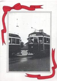
Ephemera - Christmas Card, Peter Duckett, "Single Track Days on the East Brighton Line", 1996
Christmas Card prepared by Peter and Patti Duckett and sent to Keith Kings Printed photo on exterior with red printed ribbons, photo corners on inside with another photo and gold block print and the Duckett's address. Photographs by Peter Duckett. Item made for 1996 Christmas Card titled "Single Track Days on the East Brighton Line", featuring the story of the single track extension in 1937 for the East Brighton, route 64 line. Notes the staff system in use for Safeworking. Cover photo includes the driver of W2 class 452 bound for East Brighton, picking up the staff from another car and the inside print of tram 550 at the terminus."To Keith" in ink.trams, tramways, east brighton, route 64, safeworking, staff, crossing loop, w2 class, tram 452, tram 550 -
 Melbourne Tram Museum
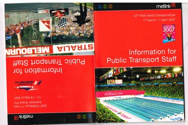
Book, Yarra Trams, "Information for public transport staff - 2007 FINA World Championships", "Information for public transport staff - 2007 Formula 1 Australian Grand Prix", Mar. 2007
Sixty four full colour publication plus covers "Information for public transport staff - 2007 Formula 1 Australian Grand Prix" and when turned upside down - "Information for public transport staff - 2007 FINA World Championships" (Swimming) Gives details of event for train, tram and bus crews, event program and transport map, including shunting details, announcements, bus replacement services, electric or automatic points, route alterations. On the back cover has contact telephone numbers and web addresses. See Reg Item 1064 for associated map. Item contained with in a plastic envelope with a black neck band. 2 copies held.trams, tramways, grand prix, metlink, formula 1, albert park, fina -
 Melbourne Tram Museum
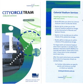
Pamphlet, Yarra Trams, "Colonial Stadium Services", "City circle tram - reduced services", c2001
Set of two DL size pamphlets, both printed on gloss white paper with Yarra Trams logos. .1 - Single sided pamphlet advertising Colonial Stadium Services - extra trams services and the routes that serve it - c2001. The Wikipedia entry for Docklands Stadium accessed 2/12/15 gives the dates for the name of the Colonial Stadium as 9/3/2000 to 1/10/2002 - see https://en.wikipedia.org/wiki/Docklands_Stadium#Naming_rights_history .2 - Double sided pamphlet titled "City circle tram - reduced services", dated January 2001 advising services reduced to the temporary withdrawal of the W class trams for maintenance - has contact numbers.trams, tramways, yarra trams, docklands, football, events, city circle, w class -
 Eltham District Historical Society Inc
Slide, Maroondah Aqueduct, Research, Victoria, 22 Mar. 1981
An inspection tour of the Maroondah Aqueduct was undertaken by the Shire of Eltham Historical Society on Sunday, March 22nd, 1981, commening where the aqueduct crosses Main Rd., Research, just below Eltham College. The Maroondah Aqueduct was part of Melbourne’s water supply system. It carried water over the 66 km from the Maroondah Reservoir on the Watts River at Healesville to the Preston Reservoir. Of this length, 41 km were open channel, 10 km, tunnel through hills and 15 km in 14 inverted siphons across stream valleys. The route of the aqueduct is north of Tarrawarra and Yarra Glen, along the Yarra escarpment south of Christmas Hills and crossing Watsons Creek into the present Shire of Eltham near Henley Rd. The eastern part of the route lies entirely within the former boundaries of the shire. The aqueduct passes south of Kangaroo Ground to Research and crosses the Diamond Creek by siphon at Allendale Rd., Eltham North. It then extends to Reservoir via St. Helena, Greensborough North and Bundoora. Water first flowed through the aqueduct in February 1891 when it was fed by a diversion weir on the Watts River. Records of the building of the aqueduct indicate that it was a significant construction achievement. The present Maroondah Reservoir was completed in 1927 and the aqueduct was enlarged at that time to take increased flows. About 1971 the section of the aqueduct through and north of Research was replaced by a large pipe and that section of the channel is now unused. The channel has remained largely intact (unlike sections at Greensborough and Bundoora where long lengths of the disused aqueduct have been demolished or filled in). The M.M.B.W. relinquished control of the disused aqueduct reserve which is crown land and the Shire of Eltham took control of this section of the reserve as a linear park. The Maroondah Aqueduct is considered to be an important historic structure, not just to the local area but to the metropolitan area generally. It is considered important to preserve substantially intact long lengths of the disused aqueduct, together with its bridges and other associated structures. 35 mm colour positive transparency (1 of 5) Mount - Agfachrome Agfa CS System black 8 dotsactivities, heritage excursion, maroondah aqueduct, research (vic.), shire of eltham historical society -
 Bendigo Historical Society Inc.
Slide - Images by Arthur Pulfer, 1957-1970
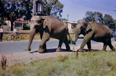
ROSEVIEW 407 High Street, Golden Square Bendigo "Roseview" was designed by Godfrey Eathorne and constructed in 1939. It is one of the few Streamline Moderne houses in the Central Goldfields region, and was one of the earliest constructed in the Bendigo region. It is an outstanding example of this style of housing. It resembles an ocean liner, and reflects the emphasis on the streamlining of methods of transportation. It utilizes both flat and curved surfaces and has little external ornamentation. The use of materials such as rounded glass windows and metal window and door frames reflects an innovative approach to construction consistent with the style. "Roseview" was constructed on a large scale, with large and spacious rooms. It reflects the prominent social status and wealth of the original owner, together with the desire for a building in 'the latest' style which was sure to attract attention and prominence in the region. It has been maintained largely in original condition. CARALULUP HOTEL 'The Sun' dated January 17, 1941 on the back. It states that 'The licence of Caralulup Hotel, near Talbot, has been surrendered, thus severing an 80 year association with the district' State Library of Victoria TOLMER GOLD ESCORT ROUTE The gold rush in New South Wales and Victoria left few able miners in South Australia. Bad economic conditions saw more than 15,000 men leave the Kapunda and Burra mines by the end of 1851. Alexander Tolmer, Commissioner of Police in 1852 proposed that the gold won by South Australians should be brought back to South Australia under an escort consisting of only a few men. In March a Gold Escort was on its way back to Adelaide with almost 6,000 ounces of gold for the vaults of the Treasury Building. After this successful trip Tolmer led two other escorts before handing over his duties. A total of eighteen gold escorts were made, the last one during November and December 1853 when Inspector Wyndham was in charge. You’ll find Gold Escort Route Monuments between Meningie, Coonalpyn and Tintinara.Many images from by Arthur Pulfer copied to slides. Twenty Slides of Bendigo: Bullen's Circus Bendigo February 1966 "Roseview", Pethard's Home at 407 High Street, Golden Square, Bendigo. 25th March 1957. House is possibly on the Midland Highway Epsom, Bendigo - 8 April 1955 Kangaroo Flat Bus Lines mini bus The Big Tree Sedgwick Road March 1972 The old Golden Gully Hotel Diamond Hill Road, Bendigo The old Lockup Eaglehawk Bendigo September 1967 Market Gardens - possibly North Bendigo North Deborah Mine photo taken from Breen Street 1958 Laying the track to get the engine into the park, looking down Mitchell Street Bendigo Engine R766 in the Victorian Railways Institute Park Railway Place Bendigo On the Methodist Church Steps Arnold street Bendigo Miner's Hut at Moliagul Basket Lunch - White Hills Botanical Gardens - St johns 100 year celebrations White Hills Swimming Pool February 1970 White Hills Botanical Gardens Bendigo Bendigo Show Parade 1958 The Arrival of the Cobb and Co Coach in Bendigo September 1963 history, bendigo, james lerk collection, golden square high school, dragon loong, white hill botanical gardens, 407 high street bendigo, r766 engine, bullens circus, caralulup, moligual, bendigo show, tolmer's gold route, kangaroo flat bus lines, eaglehawk lockup, arnold street methodist church, elephants -
 Ballarat Tramway Museum
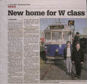
Newspaper, The Courier Ballarat, "Two new W class trams will make their home at the Ballarat Tram Museum", 16/08/2019 12:00:00 AM
Newspaper clippings from The Courier, Ballarat, 16/8/2019 titled "Two new W class trams will make their home at the Ballarat Tram Museum" about the delivery of two trams (836 and 1029) from Newport to Bungaree. Press conference held at the Ballarat depot featuring Paul Mong, Michaela Settle (Buninyong State MP) and Juliana Addison (Wendouree State MP) and Chris Phillips. Article by Greg Gliddon, photo Lachlan Bence. Items includes photographs of the trams being loaded at Newport the previous day and a photo of W6 965 en route to the Docks on its way to Denmark. See Reg Item 7396 for two video files ex VicTrackw class trams, grants, btm, donations, victorian government, tram acquisition -
 Ballarat Tramway Museum
Photograph - Black & White Photograph/s, Keith Kings, 7/03/1958 12:00:00 AM
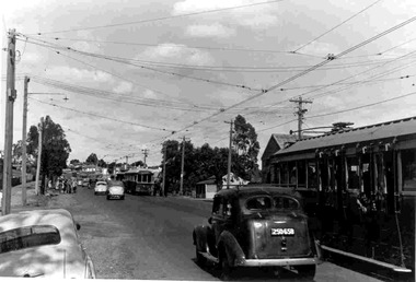
Black and White photograph contained with Reg. Item 1902 - Photo Album from Keith Kings to Les Denmead 1970. Photograph of SEC Bendigo - Manchester Loop on the Eaglehawk route, with trams 21, 2 and 23 to the city with No. 20 and 17 waiting in the loop to proceed to Eaglehawk. Part of the Bendigo Easter Fair day? Large group of people waiting to board tram in the background. A number of motor vehicles in the photo. Photo taken Easter Monday, 7/3/1958. On rear of photo is stamped "ll317A and 28.5.70", possibly indicating print manufacture dates. Keith Kings No. A(e)(12) Scanning: i - image file, p - presentation file, b - back of photograph.Stamp in top left hand corner and handwritten number with "K.S. Kings No. A(e)(12) Copyright reserved". In blue ink "Bendigo / The second track cleaning car / Depot / Easter Monday 7/3/54".trams, tramways, bendigo, easter fair, manchester loop, eaglehawk, tram 21, tram 2, tram 23, tram 20, tram 17 -
 Ballarat Tramway Museum
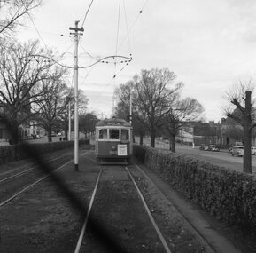
Negative - Set of 2, Geoff Grant, 25/06/1955 12:00:00 AM
Negatives No. N352 and N353 and black and white prints made by a laser printer (stored in folder ) of tram SW6's 888 travelling to Preston Depot on AETA tour (Australian Electric Traction Association) on 25/6/1955. Tram has AETA tour signs and the slogan "Electric Transport a Necessity - Protects your investment, builds your city, creates business". In route number box is letter "B". Geoff Grant's envelope notes the photos as being taken from the cabin of SW6 887. 1615.1 - In Victoria Parade - note hedges 1615.2 - in Victoria St., North Richmond, just to the west of the railway overbridge. Negative scanned hi res and imaged updated 22/5/2020.trams, tramways, melbourne, victoria st, victoria parade, aeta tour, tram sw6 888 -
 Ballarat Tramway Museum
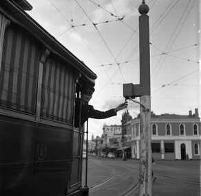
Photograph - B&W print of donated negative, John Webster, 11/4/1953
Yields information about the Bucks Head Hotel and demonstrates the way the signals were set in Bridge St for either the Mt Pleasant or Victoria St routesBlack and digital white print from a scan of a donated negative of a driver leaning out from a single trucker to set the switch on the signal for either the Victoria St or Mt Pleasant routes. Has the Bucks Head Hotel in the background. Shows the pole the signal controller or switch was mounted on. Black and White print made from scan of negative. Original Negative stored with Negatives. Image rescanned from copy neg and updated 31/5/2020. See On this basis, the envelope and marking matches that of Reg Item 4158, photo of No. 40, by John Webster and assumed taken on the same day as Item 4157, 4158, 4168, 4178 - 11/4/1953. Contained within Envelope No. 33.On left hand side of the negative in ink is "EI 35".tramways, trams, sturt st, grenville st, signals, bridge st -
 Ballarat Tramway Museum
Document - Roster, State Electricity Commission of Victoria (SECV), Ballarat - Weekdays, Saturday and Sunday Rosters, 1971
Demonstrates aspects of the Ballarat Tramways management system of Motorman's' rosters interfacing during the last full period of operation of the tramway. Shows the services and how the various run or crew tables were arranged in relation to the overall timetable. Photo copy on heat sensitive paper of a handwritten sheet on graph paper for the arrangement of the Weekdays, Saturday and Sunday Rosters on the various Ballarat routes. Gives the various run numbers, sign on location, trip take times, notes on what to do with trams, sign off times, interface with other runs. Shows the full or basic 20 min service during the day and 30 mins at night. Show how the various run or crew tables were arranged to provide the service overall. Undated, possibly August 1971 when services were revised prior to closure after the closure of the Victoria St line as it is not mentioned. 2nd copy added 3/1/2020trams, tramways, ballarat, rosters, crews, employees, shifts, timetables -
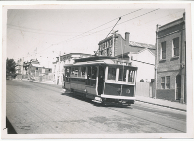 Ballarat Tramway Museum
Photograph - Digital image, Wal Jack, 26/01/1942 12:00:00 AM
Yields information about the painting of the trams for the blackout era of the Second World War time, and how it was done. Only known photograph of a tram so far in Ballarat at the time of introduction. Shows the blackout headlight mask.Digital image from the Wal Jack Ballarat Album of a photograph of No. 13 climbing the Victoria St Hill en route to Victoria St 26-1-1942. Tram has been fitted with white bumper and white steps and possible other areas as well. Note the blackout shade on the headlights. In the background is the Munster Arms Hotel and a Velvet soap ad. Wal's album notes "No. 13 Victoria St 13-1-42 white bumpers and steps, & blackout shades over head lights (War Time) See image i2 for rear of photograph. See image i3 for hi res scan of print. See image i4 for hi res scan of negativeOn rear of photograph in ink "Ballarat Tramways No. 13 climbing Victoria St hill, Ballarat East Jan 1942 / W. Jack"trams, tramways, victoria st, world war i, blackouts, tram 13 -
 Kew Historical Society Inc
Plan - Subdivision Plan, H C Crouch, Old Golf Links Estate, 1930s
The land in North Kew between the Outer Circle Railway and the River Yarra was released in sections. This release included 80 lots. Most of this area was released during the Depression years in the early 1930s.Subdivision plans are historically important documents used as evidence of the growth of suburbs in Australia. They frequently provide information about when the land was sold on which a built structure was subsequently constructed as well as evidence relating to surveyors and real estate and financial agents. The numerous subdivision plans in the Kew Historical Society's collection represent working documents, ranging from the initial sketches made in planning a subdivision to printed plans on which auctioneers or agents listed the prices for which individual lots were sold. In a number of cases, the reverse of a subdivision plan in the collection includes a photograph of a house that was also for sale by the agent. These photographs provide significant heritage information relating house design and decoration, fencing and household gardens.One part of a massive subdivision of the Old Golf Links Estate in North Kew of 80 allotments bordering Sutherland Avenue, Ramsay Avenue, Belford Road, Beresford Street and Coleman Avenue. Inset on the plan at the top left, the route of the Outer Circle Railway is clearly marked. The Kew Golf Links is identified in its current location. The land on which Greenacres Golf Club was to be constructed is at this time marked as ‘Recreation Ground’. The ‘new bridge’ over the Yarra at Burke Road is also marked on the inset map. The Plan identifies the surveyor (sic) H.C. Crouch BCE MVIS, 443 Little Collins St., Melbourne. The date of the subdivision auction sale in identified as Saturday September 25th at three o'clock.Annotations: "E" top left. "Golf Links" top right. Lots 73-76 ticked and listed as "6" poundssubdivisions -- kew (vic.), old golf links estate -
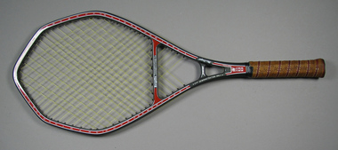 Tennis Australia
Racquet, Circa 1988
A MacGregor 'Bergelin Long String 2' model tennis racquet with polygonal head shape, open throat and handle wrapped with perforated leather. Plastic butt cap embossed with words: 'LONGSTRING/TENSION'. Net strung in diamond pattern, and net extends beyond head into open throat area. On edges of racquet, strings are routed along edge of head and shaft and anchored into handle. Manufacturer name printed along right pillar of open shaft. On left pillar is printed: 'FOR DEMONSTRATION ONLY'. Model name printed across base of head. Series of guide numbers printed around head and open throat area. Materials: Graphite, Leather, Vinyl, Ink, Adhesive tapetennis -
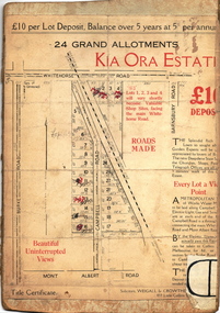 Kew Historical Society Inc
Plan - Subdivision Plan, Kia Ora Estate, 1930s
Twenty-five grand allotments were offered for sale in the subdivision known as the Kia Ora Estate in Balwyn in the early 1930s. The streets identified in the subdivision include Whitehorse Road, Barnsbury Road, Campbell Road, Mont Albert Road and Burke Road. The lots were advertised for £10 deposit, with the balance to be paid over 5 years at 5 per cent per annum. The lots bordering Whitehorse Road were nominated as potential valuable shop sites, while the Mont Albert Road lots were advertised as having ‘wonderful views’. The Outer Circle Railway Line is shown traversing the subdivision. The route of the Railway in this area is now a walking/bike track bordered by strips of parkland.subdivision plans - balwyn, kia ora estate -
 Melbourne Tram Museum
Pamphlet, Public Transport Corporation (PTC), "Free City Circle Tram", mid 1990's
Pamphlet - eight fold to DL size, full colour, titled "Free City Circle Tram" with a photo of a City Circle tram passing Flinders St station. Has information about Melbourne trams, the Melbourne Town Hall, Visitor Information, Walking Trails, a map of the route, with places of interest shown. Map shows the service via Spencer St. Has photos of 2013 and 909 as well. Has the City of Melbourne, Department of Infrastructure and Public Transport Corporation logos. Possible produced during the mid 1990's given the various logos used. .1 - As above, but with Yarra Trams and State Government logos See Reg Items 1387 and 2703 for other versions.trams, tramways, city circle, melbourne, public transport corporation, ptc -
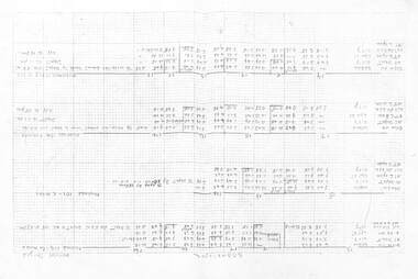
 Melbourne Tram Museum
Administrative record - Annual Report/s, Tramway Board, "Tramway Board - Report and Statement of Accounts - for period 28 Jan. 1916 to 30th June 1917", Original 1917
Photocopy - 29 A3 sheets of "Tramway Board - Report and Statement of Accounts - for period 28 Jan. 1916 to 30th June 1917", who took over the cable tram operations from the Melbourne Tramway and Omnibus Co (MTO Co). Gives details of the Board members, actions against the cable tram operator, passenger statistics, financial statements, General Managers Report, Cost and description of the undertaking, fares, routes and mileage, freehold and leasehold property, balance sheet, stats, revenue accounts, graphs of monthly revenue, passengers carried and car mileage for the period 30/6/1914 to 30/6/1917. Also lists those who enlisted for the WW1 and who died on active service.trams, tramways, cable trams, annual reports, reports, mto co, world war 1 -
 Melbourne Tram Museum
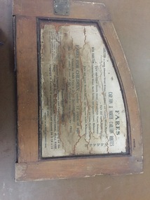
Functional object - Cable tram door frame piece/s, Melbourne Tramway & Omnibus Co. Limited, c1890
Fare board panel from Melbourne Cable tram saloon, from the inside or internal framing panels around a door. Made from soft wood, cut and assembled with wood screws, glued and then varnished. Part or panel that fitted over the end saloon window - fitted with hinges to allow access to the saloon door slide mechanism. Internal part of this part has a light colour finish on the rear. Details the fares for the Carlton / North Carlton routes. Also provides information on luggage and parcels. Issued by the MMTB. For detailed image of the panel, see the pdf file. Something not quite right when dB text opens it, open with a pdf reader to see the full text.trams, tramways, cable trams, components, fares, carlton, north carlton -
 Melbourne Tram Museum
Document - Radio Transcript, Melbourne & Metropolitan Tramways Board (MMTB), "Wireless Talk -- Mr. J. D. Barton Staff Officer MMTB - Melbourne Street Transport No. 2", late 1920's
Radio Transcript or script, 7 foolscap typed pages, double spaced titled "Wireless Talk -- Mr. J. D. Barton Staff Officer MMTB - Melbourne Street Transport No. 2". Report looks at the history of horse bus routes in Melbourne, building of the cable trams, the Parliamentary Bills for the cable trams, constructing the lines, Mr. G. Duncan, Mr. Clapp, construction difficulties, the Melbourne Tramway Trust, MTOC, drainage issues, bridges, alterations to the Act, Patent issues with a London company, opening dates and comments about wire rope. Could be a few pages missing given the way it ends, no thank you or formal ending. Item noted dated, presumed late 1920's.Has pencil notation in top left hand corner "6 copies"trams, tramways, public transport, radio stations, horse buses, mto co, melbourne, cable trams, mtt -
 Melbourne Tram Museum
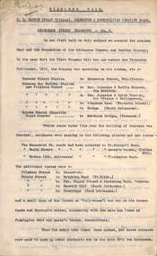
Photograph - Black & White Photograph/s, Melbourne & Metropolitan Tramways Board (MMTB), c July 1970
Black and white photograph - large format - of tram W6 940 inbound on route 5 passing under the St Kilda Junction road over bridge with Queens Way St Kilda reserve track in the background. The tram has the destination of City. The tram was the first to be fitted with marker lights - noted in Bourke St 3/7, Herald Sun 3/7 following strong public pressure. See page 5 of the June 1970 issue of Monarail, the magazine of the Monash University Railway club. See also image i2, from the June 1970 issue of TMSV Running Journal with a photo of the tram at the time of the launch. Image provided by Mal Rowe 30-9-2018.trams, tramways, st kilda junction, w6 class, queens way, tram 940 -
 Melbourne Tram Museum
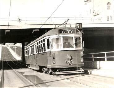
Map, Sands and McDougall Pty Ltd, "Map of Melbourne and Suburbs showing Tramways, Railways, Streets, postal districts, Quarter-Mile Radii etc", c1930
Produced by Sands and McDougall Pty Ltd of Collins St Melbourne. Map - folded sheet of paper 5 sections wide x 6 sections or folds deep contained within a dark grey paper cover titled "Map of Melbourne and Suburbs showing Tramways, Railways, Streets, postal districts, Quarter-Mile Radii etc", showing both cable and electric tramways. verted, but not Market St to Port Melbourne or South Melbourne. Shows the Collins St line being constructed. Collins St routes were opened late 1929, map produced during the early 1930's prior to the closure of Market St - Port Melbourne. Has a detailed list of the postal districts.trams, tramways, maps, melbourne, cable trams, tramways, railways -
 Melbourne Tram Museum
Negative, Wal Jack, 21/07/1951 12:00:00 AM
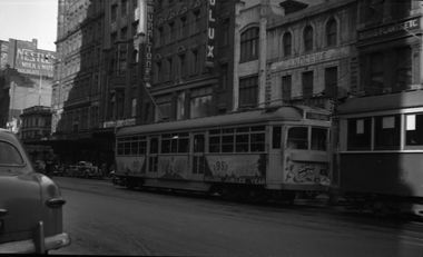
Black and white negative, by Wal Jack, of SW6 915 decorated for the Golden Jubilee of Australia, on a route 20, Coburg service in Elizabeth St, just before crossing Collins St. Has in the background Muraltune and Andrews stores and adverts for Nestle's and Dulux. Mal Rowe advised 23/8/2020 by e-mail: From the draft text of "The W book": "The first SW6 tram to be decorated was No. 915, which was painted and fitted with panels and aprons promoting fifty years of the Federation of Australia, 1901 to 1951. No. 915 ran on all lines from November, 1950 until May, 1951. In November 1951 No. 915 was fitted with roof illuminations for a six week Christmas promotion. "trams, tramways, decorated trams, elizabeth st, sw6 class, route 20, tram 915 -
 Melbourne Tram Museum
Photograph - Set of 3 Black & White Photograph/s, Sutcliffe Pty Ltd, 1939
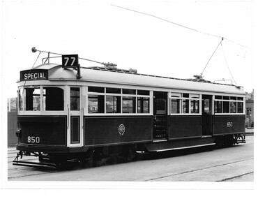
Black and white photograph of the first of SW6 class tramcars, No. 850 at South Melbourne Depot following its construction showing the tail light and the dash canopy lighting. The photograph does not have the sign "This is your car use it" as shown on the other official photograph of this tram - see page 41 of the 5th Edition of Destination City. Tram shows route 77 with the destination of Special. Photograph by Sutcliffe Pty Ltd, Illustrative Photographers of 94 Elizabeth St Melbourne. .1 - as above - from the Keith Kings collection - added 4/4/2019. .2 - as above but with the sign "This is your car use it" - added 4/4/2019. See Reg Item 3558 for another print within an album.Stamped on rear in red, with the photo number in black "Sutcliffe Pty Ltd, / Illustrative Photographers / No. 3 / 94 Elizabeth St Melbourne / CENT 1500 - 2601" (Their Melbourne central exchange phone number) .1 - Has the photographers stamp, along with Keith's details in ink on the rear "M&MTB S-A947 / SW6 - 850 / South Melbourne Depot 1939 / Note: Tail-lights & Dash Canopy Lighting, Roller Bearing Axle Boxes". Date stamp 12 Jan. 1948. .2 - Has the photographers stamp, along with Keith's details in ink on the rear "M&MTB S-A946 / SW6 - 850 / South Melbourne Depot 1939 / Note: Tail-lights & Dash Canopy Lighting, Dash Advert, Roller Bearing Axle Boxes". Date stamp 12 Jan. 1948.trams, tramways, mmtb, sw6 class, new trams, south melbourne depot, route 77, tram 850 -
 Melbourne Tram Museum
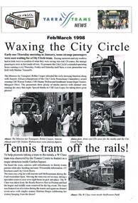
Magazine, Yarra Trams, "Yarra Tram News", 1998
384.1 - Folded A3 sheet - Feb / March 1998 issue of "Yarra Tram News", featuring articles on the City Circle tram service, tram 966 at the Tennis Centre, Customer surveys, trackwork in Victoria Parade, capital works, depots updates and Grand Prix. 384.2 - Folded A3 sheet - Aug/Sept 1988 - City circle tram award, route 70 deviation works, George Litchen, capital works and depots updates. 384.3 - Folded A3 sheet - July 1999 - Edition 17 - time keeping, OH&S, note from CEO John Wilson, website, Mercilita Manigan, depots and Yarra Power - substation DC opening issues. trams, tramways, yarra trams, city circle, tram depot, grand prix, trackwork -
 Melbourne Tram Museum
Map, Yarra Trams, "Circuit Map & Transport Guide 2007", Mar. 2007
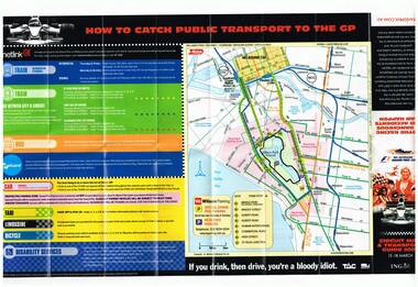
Fold out map, full colour printed on gloss paper - 8 x 2 folds. showing location of the race track, how tram and rail routes operated, restricted parking area, Metcard, where taxis and limousines could park, bicycle racks. On the reverse side has a detailed map of Albert Park showing the various race facilities and grandstands. Used for the 2007 Grand Prix. See Reg Item 1063 for associated booklet. Item contained with in a plastic envelope with a black neck band. 2 copies held. 1064.1 - similar map for the March 2004 event - see image i3. Added 11-3-2018 from donation of Hugh Waldron.trams, tramways, grand prix, metlink, formula 1, albert park, maps -
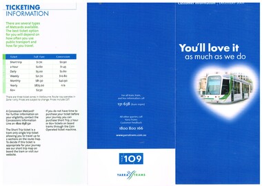 Melbourne Tram Museum
Pamphlet, Yarra Trams, "You'll love it as much as we do", "Catch a free weekend city package on tram 109", Dec. 2001
Set of two pamphlets involved the concept of the Tram 109 project, Dec. 2001. .1 - DL full colour three fold pamphlet, advertising Tram 109, new C class low floor trams and Superstops in Collins St. Also notes Metcards, how they can be validated, ticketing information and fares, location of retail outlets along the route. Has Metcard, Yarra Trams and Tram 109 logos. .2 - ditto advertising a competition to win a weekend package at Westin or Le Meridien at Rialton - buy a Metcard, fill in the entry form at the store. Has photos of the C class trams, driver console, hotels etc. Was originally contained within a plastic wrapper. Not retained with collected.trams, tramways, yarra trams, route 109, mont albert, c class, metcard, superstops -
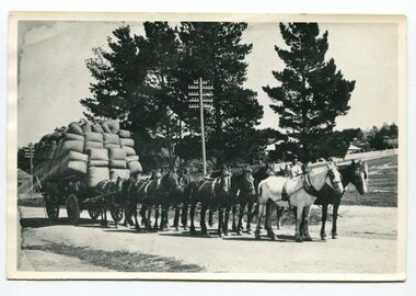 Orbost & District Historical Society
black and white photograph, 1920's -1930s
The photograph shows the wagon and team owned by Mr Tom Malinn of Sardine Creek. On lst Juy 1926, Tom Malin took over the horse drawn coach run from Orbost to Delegate. After a few years he obtained an International 2-3 ton truck. On his first trip to Bendoc he did not carry mail, but brought Miss Cunning, the first lady head teacher and collected ballot boxes. On his next trip (March 1930) he made history as the first mailman on this route to deliver mail in a motor vehicle. (info. Bendoc History) Tom and Sophie Malinn farmed at Martin’s Creek. Sophie (nee Jensen) married Tom Malinn in 1926. Sophie’s family had run the historic “Danebo Hotel” at Martin’s Creek for many years, and in 1931, Tom and Sophie began farming at Martin’s Creek, initially cropping maize and beans. This is a pictorial history horse-drawn transport used widely in Orbost until the late 1920sA black / white photograph of a large wagon loaded with wool bails being pulled by a team of horses. a man is standing behind the horses in the background.on back -"Tom Malinn with wool from Bonang"malinn-tom-bonang transport-horse-drawn -
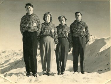 Kiewa Valley Historical Society
Photographs – Skippy St Elmo and other skiers – Set of 8 black and white photographs
Skippy and Toni St Elmo were responsible for early developments at the Falls Creek resort and for promoting a love of skiing. They left Melbourne in 1945 and settled at Falls Creek and moved into the first building constructed of corrugated iron and timber at Falls Creek in 1946. They were Falls Creek’s first workers with Toni employed by the State Electricity Commission to record weather-related data up to the construction of the Kiewa Hydro-Electric Scheme. In 1957, Toni was involved in building the first rope tow called Nissen on the same route as the Summit Quad. He also established the Nissen Ski School with ski instructor Milan Kovacic and was involved in the building of the resort’s first ski club Bogong in 1949. Toni taught Skippy to ski and she practised on the High Plains where she and her husband lived. Skippy St Elmo won many ski races during the 1950’s and represented Australia in New Zealand.Skippy and Toni St Elmo were pioneers of the Falls Creek area, promoting local ski sports and tourism. The played an important role in opening up the Falls Creek area and developing its sporting potential by establishing the first ski school, ski lifts and early lodge facilities. Skippy and Toni St Elmo were honoured at the Alpine Village at Falls Creek on November 17 2006, with the spreading of their ashes at the place which played such an important part in both their lives.Set of 8 black and white photographs of Skippy St Elmo and other skiers 1. Skippy and 3 others in New Zealand 1951 2. Skippy and 5 others Falls Creek 1955 3. Cake celebrating 20 years of sport at Nissen Lodge 4. Skippy and friend outside Nissen Lodge 5. Skippy on the ski slopes 6. Skippy on the ski slopes 7. Albury Ski Club team New Zwealand 1957 8. The Bogong Ski Club 1950 Written on back of photos 1. Bob Howe Albury, Skippy New Zealand 1951 – 942H 2. Falls Creek 1955. Skippy St Elmo: H Devonassore; Margaret ?; ?; Tony St Elmo; Olive? 3. Written on cake Nissen Alpine Club. 20 years of sport. FRED 4. Skippy St Elmo 5. Skippy 6. Skippy 7. Bob Howe (Albury) Skippy New Zealand 1957. Albury Ski Club Team raced in NZ 8. The Bogong Ski club, Coronet Park, 1950. M Denham (Capt); B Wiltshire; R Roberts; Skippy St Elmo; Gwen Morris; J Frazer; J Smith; L Piera; Manager & Coach Toni St Elmo. J D Knowles Photographer Box 188, Queenstown. 744B falls creek, skiing, bogong high plains