Showing 10994 items matching "land "
-
 Orbost & District Historical Society
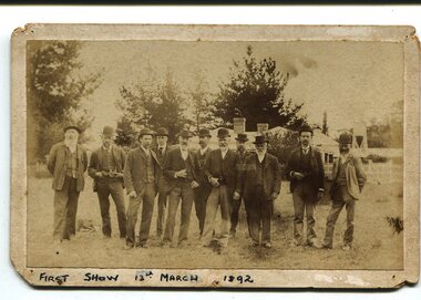
Photograph, March 13 1892
This photograph shows members of the first Orbost Agricultural Show committee.. The first meeting to form an Agricultural society in Orbost was convened by the then Orbost Progress Association and held in the Mechanics Hall on Saturday, 10th October 1891. Its first show was held on 3rd March 1904...on a site alongside the Bonang Road where the present Golf Club stands. It is currently held at the Recreation Reserve at Newmerella. (Ref: In Times Gone By-Deborah Hall) This item is associated with the Orbost Agricultural Society 's Annual Show which has been a major event in Orbost for over a century. Agricultural shows are an important part of cultural life in small country towns and the Orbost Show is an integral part of Orbost 's agricultural history.A sepia photograph of eleven men, wearing suits and waistcoats, standing on a vacant block of land. In the background are houses among tress. The photograph is mounted on grey card - rectangular with rounded corners.on back -"Toby Nixon" on front - "First Show 13th March 1892"orbost-agricultural-society annual-show-orbost agriculture-orbost -
 Federation University Historical Collection
Book, Historic Sites Survey: North Central Study Area, 1979, 1979
The North Central Study Area included the Shires of Avoca, Bet Bet, east Loddon, Goulburn, Untly, Kara Kara, Korong, Maldon, Marong, Metcalfe, McIvor, Newstead, Strathfieldsaye, Stawell, Talbot, Clunes, Tullaroop and Waranga. 153 page book with white plastic binding. It is an historic sites survey for the North Central Study Area commissioned by the Land Conservation Council, the Ministry for COnservation and the Australian Heritage Commission. castlemaine, mount alexander goldfield, maldon, percydale, warrenmang, moliagul, tarnagulla, stuart mill, the whipstick, whroo, rushworth, graytown ironbark forest, st arnoaud, new bendigo, landsborough, inglewood, kurting, wedderburn, wehla, kooroora, langham flat, mcintyre, rheola, diamond hill, fosterville, coliban water works, green gully, newstead, muckleford forest, costerfield, graytown, bailieston, waranga irrigaiton system, eucalyptus distillery, mia mia bridge, korokubeal township researce, concegella slate quarry, chewton, fryerstown, kingower, timor, talbot, majorca, carisbroook, clunes, st arnaud, taradale, icomos, dunolly, limestone, castlemaine slate quarry, harcourt granite, taradale railway viaduct, loddon united waterworks trust, gouldburn weir, carisbrook lock-up, history of tree planting in streets, history of public reserves, r.u. nicholls nurseryman, thomas lang, francis moss, ballarat botanical gardens, ballarat school of mines botanical gardens, lake wendouree, victoria park, ballarat, muont holled smith, ballaarat old cemetery planting, eastern oval, ballarat east botanical gardens, ballarat east town hall gardens, eureka stockade reserve, ballarat observatory plantings, yarrowee creek plantings, yarrowee bluestone channels, ballarat woollen mill, band and albion mullock heap, black hill plantings, yarrowee creek channels, canadian creek channel, specimen vale channel, poverty point reserve, union jack reserve buninyong, imperial mine, buninyong, victoria street plantings, bridge mall, sturt street gardens, ballarat avenue of honour plantings, white flat oval plantings, camp street, elms, burnt creek -
Glenelg Shire Council Cultural Collection
Photograph - Photograph - Portland Harbour, Jun-92
Port of Portland Authority ArchivesFront: Back- 7/92- Blue pen Back: Testport of portland archives, reclamation area -
Glenelg Shire Council Cultural Collection
Photograph - Photograph - Portland Harbour, Jul-92
Port of Portland Authority ArchivesFront: Back- 7/92- Blue biroport of portland archives, portland maritime discovery museum, crane, portland harbour -
Bendigo Historical Society Inc.
Map - CAMPBELL COLLECTION: BENDIGO & DISTRICT MAPS
Map. Bendigo Whipstick, Scale 40 chains to 1 inch, Forests Commission Victoria, map N0.3, legend for roads and land and forest. (number 371 in map cupboard 1)map, bendigo, country lands -
Port Melbourne Historical & Preservation Society
Photograph - Aerial view of Port Melbourne, 1993
Two large colour aerial view photographs of Port Melbourne piers and surrounds: .01 - View from land .02 - View from the bay Abel Tasman is at Station Pierpiers and wharves - station pier, piers and wharves - princes pier, piers and wharves - webb dock, built environment - domestic, transport - shipping, abel tasman, port melbourne primary school, missions to seamen -
 Bendigo Historical Society Inc.
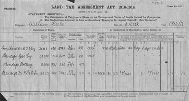
Document - GLENYS MCKITTERICK COLLECTION: WILLIAM BEEBE DOCUMENTS
Land Tax Assessment Act 1910-1914.William Beebe A/10062, 1915/16. Sandhurst N.D.T.E. Coy, Bendigo Gas Coy, Bendigo Pottery, Bendigo M.P.& B.Soc.person, bendigo, william beebe, beebe, land tax assessement. -
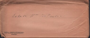 Bendigo Historical Society Inc.
Document - MCCOLL, RANKIN AND STANISTREET COLLECTION: ESTATE OF WILLIAM HENRY FOWLER - KERANG, 1934/39
Documents: envelope contains - 1935 Share farmer agreement, 1935 Lease, 1934 Lease agreement for grazing land Kerang, 1934 Lease agreement Mr Jas Thompson & Ors.MCCOLL RANKIN AND STANSISTREETorganization, business, gold mining - legal, mccoll rankin and stansistreet -
Bendigo Historical Society Inc.
Document - HARRY BIGGS COLLECTION: DOCUMENT ABOUT PIECE OF LAND
Document. Harry Biggs Collection. This piece of card has some writing on it which appears to be about a piece of land. It is only a fragment so is difficult to know what it is all about.cottage, miners, harry biggs collection, wade street golden square, foggitt & jones, roberts osborne & co. pty. ltd. (ham & bacon curers) -
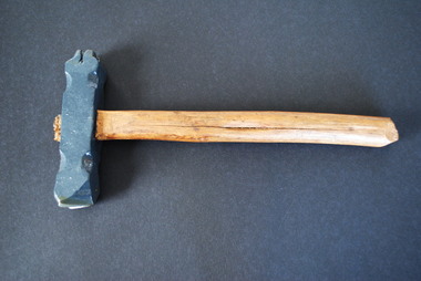 Anglesea and District Historical Society
Forestry Branding Hammer, Unknown
Old logging stamp hammer, double-sided, iron head on wooden handle. F.C. on one end. Arrow on the other end. Probably used to mark trees on public land.F.C. on one end of head. Arrow on other end of head. Metal head painted grey.forestry commission, branding hammer -
 Victorian Aboriginal Corporation for Languages
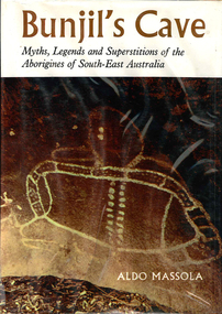
Book, Aldo Massola, Bunjil's cave : legends and superstitions of the Aborigines of South-East Australia, 1968
Stories from the Aboriginal people of South-East Australia. Includes Creation Stories, Myths and legends. Written in two sections, The myths and The Land Beyond the Sky. Includes location lists.Maps, b&w photographs, illustrationswotjobaluk, mara, kulin, kurnai, murray river, myths, legends, creation stories -
 Whitehorse Historical Society Inc.
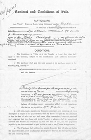
Document, Contract and conditions of sale, 1909
Copy of contract dated 19 April 1909 between the Freehold Investment and Banking Company of Australia Ltd and Julius Draeger. Portion of land allotment 94 known as Glebe Paddock.non-fictionland subdivision, glebe paddock, draeger, carl julius otto, freehold investment and banking company of australia ltd, t. r. b. morton & son -
 Whitehorse Historical Society Inc.
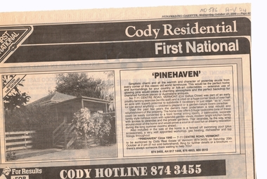
Newspaper, Pinehaven, 17/10/1990 12:00:00 AM
Advertisement for auction of 'Pinehaven' built circa 1940, 7 - 11 Centre Road, Vermont (cnr Gallus Close).Advertisement for auction of 'Pinehaven' built circa 1940, 7 - 11 Centre Road, Vermont (cnr Gallus Close). Land size 1/2 acre, sub-division potential.Advertisement for auction of 'Pinehaven' built circa 1940, 7 - 11 Centre Road, Vermont (cnr Gallus Close).pinehaven, centre road, vermont, nos 7-11, poultry, gallus close, cody first national real estate -
 Whitehorse Historical Society Inc.
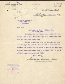
Letter - Correspondence, Mitcham Road, 1932
Correspondence between Shire Secretary, Shire of Blackburn and Mitcham and vendors and their solicitors re transfer of land for a road between Mitcham Road and Creek Road, Mitcham, June - July 1932.mitcham road, mitcham, creek road, mitcham, shire of blackburn and mitcham, maddocks, jamieson & lonie, solicitors, ashley (mr), bloom, f.a., roads and streets -
 Mt Dandenong & District Historical Society Inc.
Photograph
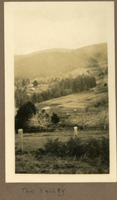
The photograph is from the album of Ivy Child and shows a view across the Kalorama Valley sometime between 1927 and 1932. Ivy May Child (1910 – 1989) was the daughter of Arthur Edward (Ted) Child (1878 – 1964) and Ethel May Madden (1888 – 1970). Ted Child was the son of Matthew Francis Child (1839 – 1933) and Martha Jeeves (1857 – 1926). He was the grandson of one of the early pioneers Francis Child. Ivy grew up on the family property on Childs Road and took many photographs. Most of these are glued into her photo album. The album covered the years from c1927 – 1932. Ivy married Henry William Burgess (1906 – 1968) in 1944. The photographs remain in their original state in the album with individual copies made. Sepia coloured photograph with a wire and pole fence in the foreground of a sweeping view across a valley. Numerous roof tops are visible in the distance. The land has been cleared. Hills are in the distance.Written below the photograph in the album: The Valleykalorama valley, kalorama, ivy child -
 Kew Historical Society Inc
Plan, J R Mathers & McMillan, Sackville, Thomas & Lytton Streets, Kew, Twentieth Century
The Kew Historical Society's map collection includes a substantial number of real estate subdivision plans, mainly of Kew but also of surrounding suburbs in Melbourne. Most of the subdivision plans date from the 1920s and 1930s when the districts old homes and local farmland were being split up to accommodate residential growth in the postwar period. These early plans were assembled by a local firm, Jas R Mather & McMillan, which had an office in Cotham Road. Many of the plans, and sometimes photos, were annotated by the agents.Subdivision plans are historically important documents used as evidence for the growth of suburbs in Australia. They frequently provide information about when the land was sold as well as evidence relating to surveyors and real estate and financial agents. The numerous subdivision plans in the Kew Historical Society's collection represent working documents, ranging from the initial sketches made in planning a subdivision to printed plans on which auctioneers or agents listed the prices for which individual lots were sold. In a number of cases, the reverse of a subdivision plan in the collection includes a photograph of a house that was also for sale by the agent. These photographs provide significant heritage information relating house design and decoration, fencing and household gardens.The photograph may also be aesthetically significant depending on the importance of the photographic atelier.Lithographed subdivision plan for an un-named estate with 28 allotments facing Lytton, Sackville and Thomas Streets in Kew. The land would have originally formed part of the Dumaresq Estate. subdivision plans - kew, lytton street, sackville street, thomas street - kew -
Canterbury History Group
Pamphlet - Camberwell Golf Links, c1932 original
Brochure produced for Land Sub-division sale by auction of Camberwell Golf Links on Saturday 28 May c1932. Reproduced from the original, includes Map and some historic photographscamberwell, fairmont avenue, camberwell road, christowell street, trams, vintage cars -
 Ringwood and District Historical Society
Document - Subdivision Map, Part of Crown Sections 18, 19, 24 & 25, Parish of Warrandyte, County of Evelyn, Vol 5228 Fol 472 - 1926. (Park Orchards, Victoria)
A3 and A4 sized photocopies showing map section of land title showing streets, easements and allotment numbers, some with handwritten names and pricing notations circa mid 1950s.Map includes Valley Road, Granard Avenue, Park Road, Arundel Avenue, Hylton Avenue, Aviemore Avenue, Bowmore Avenue, Hopetoun Road, Colin Avenue, Daintree Avenue, Brucedale Crescent, Feversham Avenue, Ennismore Crescent, Iona Grove, Elgin Crescent and Gosford Crescent, Park Orchards, Victoria. -
 Ringwood and District Historical Society
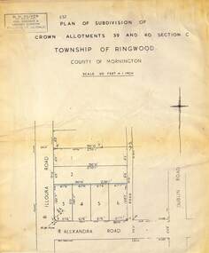
Map - Plan of Subdivision, Part of Crown Allotments 39 and 40 Section C, Township of Ringwood, County of Mornington - (Undated - circa 1930s)
Copy of land title map on light cardboard backing showing layout and size of 6 allotments in Illoura Road (later Illoura Avenue) and Alexandra Road, Ringwood East, Victoria. Rubber stamp imprint in top left corner - D.H. Oliver, Civil Engineer & Licensed Surveyor, Bellevue Street Lilydale, Phone Lilydale 91. -
 Kew Historical Society Inc
Plan - Subdivision Plan, Jas R Mathers Son & McMillan, Clifton Estate, Kew, c. 1916
Pru Sanderson, in her groundbreaking ‘City of Kew Urban Conservation Study : Volume 2 - Development History’ (1988), summarised the periods of urban development and subdivisions of land in Kew. The periods that she identified included 1845-1880, 1880-1893, 1893-1921, 1921-1933, 1933-1943, and Post-War Development. These periods were selected as they represented periods of rapid growth or decline in urban development. An obvious starting point for Sanderson’s groupings involved population growth and the associated economic cycles. These cycles also highlighted urban expansion onto land that was predominantly rural, although in other cases it represented the decline and breakup of large estates. A number of the plans in the Kew Historical Society’s collection can also be found in other collections, such as those of the State Library of Victoria and the Boroondara Library Service. A number are however unique to the collection.The Kew Historical Society collection includes almost 100 subdivision plans pertaining to suburbs of the City of Melbourne. Most of these are of Kew, Kew East or Studley Park, although a smaller number are plans of Camberwell, Deepdene, Balwyn and Hawthorn. It is believed that the majority of the plans were gifted to the Society by persons connected with the real estate firm - J. R. Mathers and McMillan, 136 Cotham Road, Kew. The Plans in the collection are rarely in pristine form, being working plans on which the agent would write notes and record lots sold and the prices of these. The subdivision plans are historically significant examples of the growth of urban Melbourne from the beginning of the 20th Century up until the 1980s. A number of the plans are double-sided and often include a photograph on the reverse. A number of the latter are by noted photographers such as J.E. Barnes.The Clifton Estate was an ambitious subdivision. It included 61 allotments bordering Cotham and Park Hill Roads, and Florence and Adeney Avenues. It is difficult to ascertain the exact year when the ‘Clifton Estate’ was surveyed, subdivided and first auctioned. The uncertainty may be due to allotments being released during the First World War. The subdivision took its name from the house ‘Clifton’ (lot 5) on the corner of Adeney Avenue and Cotham Road. The outline of Clifton (since demolished) and the extent of its land following the subdivision are represented on the plan. The auctioneers have also shown ‘Maryfield’ and ‘Wimba’, the neighbouring properties in Cotham Road, on the plan."B"subdivision plans - kew, clifton estate, cotham road, adeney avenue, florence avenue, park hill road -
 Bendigo Historical Society Inc.
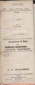
Document - H.A. & S.R. WILKINSON COLLECTION: CONTRACT OF SALE
Conditions of sale by private contract dated 21st. October, 1935 between J. Mahon (seller) and H. Taylor (buyer) for land situate Hodgkinson Street, Bendigo having a frontage of approx. 52 feet by a depth of approx. 108 feet, being parts of lots 6 and 7 on plan of subdivision registered No.13862 part of Crown allotments 6 and 7 section 38C land described in Crown grant volume 1502 folio 300225 and Crown grant volume 2642 folio 528242. Price 50 pounds. Attached receipt and plans to build house on that land (W. H. Ellis builder) for 500 pounds also attached detailed list of materials and labour.organization, business, h.a. & s.r wilkinson real estate -
 Bendigo Historical Society Inc.
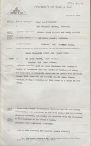
Document - H. A. & S. R. WILKINSON COLLECTION: CONTRACT OF SALE
Contract of sale of land dated 4th October, 1955 between Mr. R. F. & Mrs. B. Wootton (vendor) and Mr. E. W. & Mrs. S. Peers (purchaser). Solicitor for vendor: Neal & Woodward. Solicitor for purchaser: Cohen, Kirby & Co. Property: land being part of Crown allotment 201 section K land described in certificate of title volume 7304 folio 627 and situate No. 33 Moran Street, Bendigo, having a frontage of 100.5 links y a depth of 170 links, together with 5 room weatherboard dwelling also all blinds electric stovette, all linos and curtains with the exception of the curtains in the front 2 rooms. Price: 2,600 poundsorganization, business, h.a. & s.r wilkinson real estate -
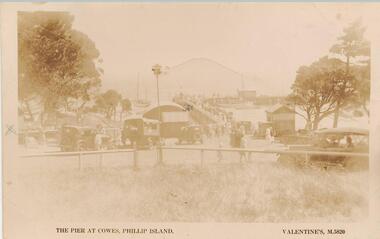 Phillip Island and District Historical Society Inc.
Photograph - Post Card, Early 1900's
One of 17 photographs donated by Olive BlameySepia postcard looking towards the Cowes Pier. Cars and people in the foreground. Jetty shed at the left of the pier and small building to the right. People on the pier with yachts moored and sailing."The pier at Cowes, Phillip island." "Valentine, M 5820." Letter on back from Freda to Jean explaining where they land at Phillip Island and how to get to their place.cowes pier phillip island, cowes jetty, cowes jetty foreshore, phillip island, olive blamey -
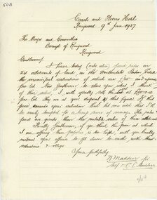 Ringwood and District Historical Society
Letter, Letter from N Madden to Mayor and Councillors , Borough of Ringwood. 1937
Hand written letterLetter is from N.Madden -Coach and Horses Hotel, to the Ringwood Borough Council, dated 9th June 1937. Contents regarding Allotments of land in the Heatherdale Station Estate. -
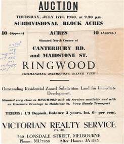 Ringwood and District Historical Society
Flyer - Land Auction Sale, Ten Acres, Maidstone Street Ringwood - 1958
Double sided page advertising Auction, Thursday, July 17th, 1958, (Approx.) 10 Acres, north corner of Canterbury Road and Maidstone Street, Ringwood. Agents - Victorian Realty Service Pty.Ltd., 360 Lonsdale Street, Melbourne, Phone MU7858, After Hours JA1045. Reverse side shows map of proposed subdivision by K.J. Noonan & Co., Surveyors & Engineers, 495 St.Kilda Rd, Melbourne, marked subject to approval of all interested statutory authorities.Residential zoned subdivision land for immediate development. Extensive frontage to Maidstone Street. Accompanying handwritten annotation "10 acres offered as a whole, later re-subdivided". -
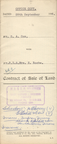 Bendigo Historical Society Inc.
Document - H.A. & S.R. WILKINSON COLLECTION: CONTRACT OF SALE
Contract of sale of land dated 28th September, 1956 between G.A. Cox (seller) and Mr. R.L. & Mrs. E. Roche (buyer) for land being lot 1 on plan of subdivision No. 18242 part of Crown allotment 337 section E described in certificate of title volume 7132 folio 389 and situate no. 150 White Hills Road, Bendigo, together with 5-roomed brick dwelling and all sundry. Price 4,750 pounds.organization, business, h.a. & s.r wilkinson real estate -
 Bendigo Historical Society Inc.
Document - H.A. & S.R. WILKINSON COLLECTION: CONTRACT OF SALE
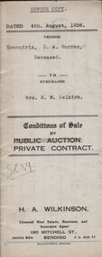
Conditions of sale by private contract dated 4th August, 1936 between Executrix of the will of S.A. Burren Deceased (seller) and Mrs. E.M. Selkirk (buyer) for that piece of land situate No.317 McIntyre Street, Long Gully being the land described in residence area right No. 323, together with 4-roomed weatherboard dwelling and all sundry. Also all window blinds, curtains, linos on the floors and electric light fittings. Price 210 pounds.organization, business, h.a. & s.r wilkinson real estate -
 Bendigo Historical Society Inc.
Document - H.A. & S.R. WILKINSON COLLECTION: CONDITION OF SALE
Contract of sale of land dated 16th November, 1954 between Mr. W.A. Haywood (seller) and Mrs A.E. Pendlebury for land situate corner Brown and Green Streets, Long Gully being allotment 500A section K described in residence licence 0943 129, together with 2-roomed cement brick dwelling and all sundry, also electric copper and cement troughs, concrete mixer and concrete moulds. Price 450 pounds.organization, business, h.a. & s.r wilkinson real estate -
 Bendigo Historical Society Inc.
Document - H.A. & S.R. WILKINSON COLLECTION: CONDITION OF SALE
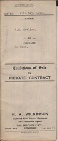
Conditions of sale by private contract dated 20th May, 1943 between A.E. Cowling (seller) and H. Rice (buyer) for land situate Wood Street, Long Gully having a frontage of 150 links to Wood Street by a depth of 200 links and being the land described in right to occupy residence area title No. 4719 due 23/08/1943, together with 5-roomed weatherboard dwelling and all sundry. Price 225 pounds.organization, business, h.a. & s.r wilkinson real estate -
 Bendigo Historical Society Inc.
Document - H.A. & S.R. WILKINSON COLLECTION: CONDITION OF SALE
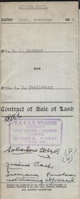
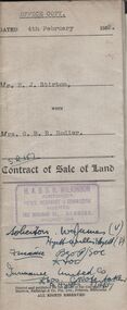
Contract of sale of land issued by H.A. Wilkinson and dated 4th February 1952 between Mr. E.J. Stirton (seller) and Mrs. G.B.R. Rodier (buyer) for land being allotment 12A section 49B, Parish of Sandhurst, City and County of Bendigo described in Crown grant volume 2580 folio 515907 situate No. 325 Barnard Street Bendigo together with 4-roomed weatherboard dwelling and all sundry. Price 880 pounds.organization, business, h.a. & s.r wilkinson real estate