Showing 23714 items
matching creeks
-
 Bacchus Marsh & District Historical Society
Map, Lerderderg Park Lands sale plan. 1911
This plan was for the sale of parcels of land from the Lerderderg Park Estate property in 1911. Advertising for the sale appeared in the Bacchus Marsh Express newspaper through July of 1911. The property was situated only a few kilometers from the township of Bacchus Marsh. The agents for the sale were L. A. Fairbairn & Co.Lerderderg Park Estate was a significant and early colonial property in the Bacchus Marsh area. This plan provides details about the first time the property was subdivided for sale. It is therefore documents an important moment in the history of this property and the broader trend of the subdivision of older and larger properties in the district.A single page paper plan showing allotments of land for sale from the Lerderderg Park property owned by John Wills. The parcels of land for sale are coloured in red.The Lerderderg River and Pyke's Creek Irigation Channel shown on the plan are in blue ink. The rest of the plan is a dark cream or beige colur with the text in black ink. The plan has been extensively annotated with hand-written notes indicating the names of people who purchased the various parcels of lands and the prices paid for those lands. Part of the top of the plan containing some text appears to be missing. The plan is pasted into a bound volume containing 76 maps or plans in total. Top: Have received instructions to Sell, account Mr John Wills, his renowned LERDERDERG PARK LANDS, so well and favourably known throughout the Commonwealth. In areas from 3 acres to 1276 acres. Every lot is either rich lucerne land (or portion now under lucerne) with some higher land adjoining Railway Station, and 2 Milk factories within 2 miles, absolutely the finest land in Victoria. Bottom: THIS IS THE FIRST SUBDIVISIONAL SALE of Rich Flats in Bacchus Marsh since the Pyke's Creek Scheme, and every lot is commanded by it. Only 32 miles from Melbourne.bacchus marsh victoria maps, land sales, lerderderg park estate, land subdivision -
 Eltham District Historical Society Inc
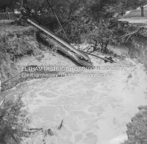
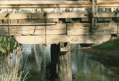
Album - Photograph, J.A. McDonald, Dixons Creek Road, 23 Sep. 1955
Dixons Creek in flood Temporary bridge washed outRecord of various Shire of Eltham infrastructure works undertaken during the period of 1952-1962 involving bridge and road reconstruction projects, sometimes with Eltham Shire Council Project Reference numbers quoted. It was during this period that a number of significant improvements were made to roads and new bridges constructed within the shire that remain in place as of present day (2022). In many situations, the photos provide a tangible visible record of infrastructure that existed throughout the early days of the Shire. The album was put together by or under the direction of the Shire Engineer, J.A. McDonald.1955-09-23, bridge construction, dixons creek bridge, dixon's creek road, flood damage, floods, infrastructure, road construction, shire of eltham -
 Eltham District Historical Society Inc
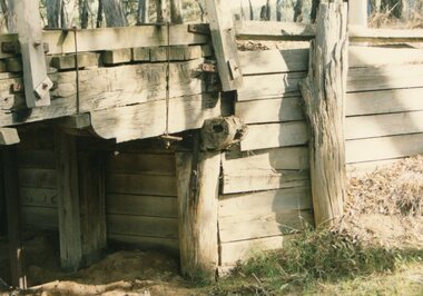
Album - Photograph, J.A. McDonald, Dixons Creek Road, 21 Oct. 1953
Scour on Dixons Creek Road 21st October 1953Record of various Shire of Eltham infrastructure works undertaken during the period of 1952-1962 involving bridge and road reconstruction projects, sometimes with Eltham Shire Council Project Reference numbers quoted. It was during this period that a number of significant improvements were made to roads and new bridges constructed within the shire that remain in place as of present day (2022). In many situations, the photos provide a tangible visible record of infrastructure that existed throughout the early days of the Shire. The album was put together by or under the direction of the Shire Engineer, J.A. McDonald.infrastructure, road construction, shire of eltham, bridge construction, dixons creek bridge, dixon's creek road, 1953-10-21 -
 Eltham District Historical Society Inc
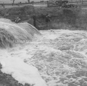
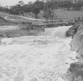
Album - Photograph, J.A. McDonald, Eltham-Yarra Glen Road, 26 Jan. 1956
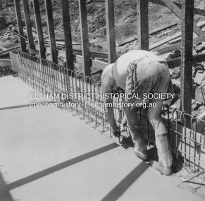
Watsons Creek Floor pour 27th January, 1956Record of various Shire of Eltham infrastructure works undertaken during the period of 1952-1962 involving bridge and road reconstruction projects, sometimes with Eltham Shire Council Project Reference numbers quoted. It was during this period that a number of significant improvements were made to roads and new bridges constructed within the shire that remain in place as of present day (2022). In many situations, the photos provide a tangible visible record of infrastructure that existed throughout the early days of the Shire. The album was put together by or under the direction of the Shire Engineer, J.A. McDonald.infrastructure, road construction, shire of eltham, bridge construction, eltham-yarra glen road, w.e. wolf, watsons creek, 1956-01-27 -
 Eltham District Historical Society Inc
Album - Photograph, J.A. McDonald, Eltham-Yarra Glen Road, 26 Jan. 1956
Watsons Creek Floor pour 27th January, 1956Record of various Shire of Eltham infrastructure works undertaken during the period of 1952-1962 involving bridge and road reconstruction projects, sometimes with Eltham Shire Council Project Reference numbers quoted. It was during this period that a number of significant improvements were made to roads and new bridges constructed within the shire that remain in place as of present day (2022). In many situations, the photos provide a tangible visible record of infrastructure that existed throughout the early days of the Shire. The album was put together by or under the direction of the Shire Engineer, J.A. McDonald.infrastructure, road construction, shire of eltham, bridge construction, eltham-yarra glen road, w.e. wolf, watsons creek, 1956-01-27 -
 Eltham District Historical Society Inc
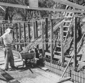
Album - Photograph, J.A. McDonald, Old Healesville Road, Sep. 1958
Paul Creek Road September 1958 Looking eastRecord of various Shire of Eltham infrastructure works undertaken during the period of 1952-1962 involving bridge and road reconstruction projects, sometimes with Eltham Shire Council Project Reference numbers quoted. It was during this period that a number of significant improvements were made to roads and new bridges constructed within the shire that remain in place as of present day (2022). In many situations, the photos provide a tangible visible record of infrastructure that existed throughout the early days of the Shire. The album was put together by or under the direction of the Shire Engineer, J.A. McDonald.infrastructure, shire of eltham, bridge construction, road construction, old healesville road, paul creek road, 1958-09 -
 Eltham District Historical Society Inc
Negative - Photograph, J.A. McDonald, Heidelberg-Kinglake Road, 11 May 1961
Yow Yow Creek bridge 11 May 1961Record of various Shire of Eltham infrastructure works undertaken during the period of 1952-1962 involving bridge and road reconstruction projects, sometimes with Eltham Shire Council Project Reference numbers quoted. It was during this period that a number of significant improvements were made to roads and new bridges constructed within the shire that remain in place as of present day (2022). In many situations, the photos provide a tangible visible record of infrastructure that existed throughout the early days of the Shire. The album was put together by or under the direction of the Shire Engineer, J.A. McDonald.1961-05-11, heidelberg-kinglake road, infrastructure, bridge construction, shire of eltham, yow yow creek -
 Greensborough Historical Society
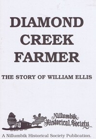
Book, Diamond Creek Farmer, 1850o
History of the Ellis family in Diamond Creek and Yarra Glen.William Ellis emigrated to Victoria in 1847 and bought most of the Wattle Glen area in 1850. He also had family connections to Kangaroo Ground.A black and white booklet, 12 pages, black and white illus.John Mackey in pencil inside front coverwattle glen, kangaroo ground, nillumbik historical society, william ellis, diamond creek, farming, walters family, ellis cottage -
 Eltham District Historical Society Inc
Photograph, Looking west along Bridge Street, from Main Road, Eltham, February 1968, Feb 1968
Shows the Diamond Creek bridge and part of Susan Street In February 1968 an unknown person took a series of photos from the Eltham Hotel at Pitt Street heading north along Main Road through the shopping centre to just north of Elsa Court covering the length of the section of Main Road which was duplicated shortly thereafter. Shows the condition and environment of the streesscape of Main Road, Eltham immediately prior to the duplication between Pitt Street and Elsa Court through the shopping centre. Also shows a number of shops and businesses that operated at that time.Black and white photographduplication, eltham, main road, bridge street, susan street -
 Kiewa Valley Historical Society
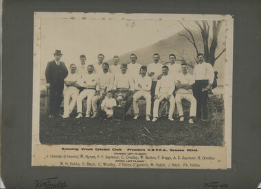
Photo - Running Creek, Photo - Running Creek Cricket Club Premiers UKVCA, Season 1913-14
Running Creek had a cricket team in 1913-14.The donor Genieve was the granddaughter of Ella Sullivan. Ella was one of 5 daughters of Denis and Margaret (nee Tolmie) Sullivan who lived at Tawonga (Coral Bank). 'Sullivan's Lane'. Ella married John (Jack) Fahey and they lived for some time at Fahey's Lane, Running Creek. J. Fahey is listed as Captain in the photo. The child's name is not known but it is possible it's Jack's son by the sitting position.Sepia coloured large photo of 13 Cricketers and 2 men, one at each end. Underneath the photo is the name of the event and the names of the cricketers and umpire. The photo is mounted on grey cardboard with 'Vine's Studios' and 'Wangaratta' inscribed. running creek, cricket team in 1913-14 in the kiewa valley, genieve meyer -
 Stawell Historical Society Inc
Photograph, Presentation of Restoration Plaque for the Pleasant Creek Court House
Presentation of Restoration Plaque (Pleasant Creek Court House)stawell -
 Stawell Historical Society Inc
Photograph, Grampians Fyans Creek Weir for the Stawell Water Supply
Grampians Fyans Creek Weir (Stawell Water Supply)stawell -
 Ballarat Heritage Services
Souvenir - Postcard Booklet Image, The Blowhole, Hepburn, Victoria, c1945
The Blowhole was blasted by Chinese miners to divert Sailor's CreekA black and white photographic image of the Blowhole at Hepburn.blowhole, hepburn, sailors creek -
 Sunbury Family History and Heritage Society Inc.
Photograph, 1935
The waterfall is in Jacksons Creek downstream from the Sunbury township.A black and white photograph with a cream border of a waterfall in a river. A gnarled tree is growing on the bank and there is a hill in the middle distance.waterfalls, jacksons creek, sunbury -
 Stawell Historical Society Inc
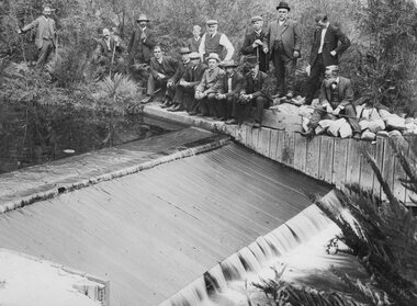
Photograph, Stawell Water Supply fluming at Bovine Creek in the Grampians
Grampians - Stawell Water Supply fluming at Bovine Creek -
 Stawell Historical Society Inc
Photograph, Greens Creek School Number 1381 1927
New School - Greens Creek No. 1381 opened 1927stawell education -
 Stawell Historical Society Inc
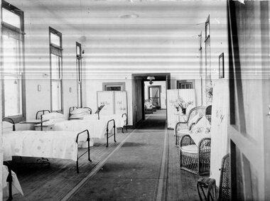
Photograph, Pleasant Creek -- Stawell Hospital Syme Ward Interior
Pleasant Creek. Stawell Hospital Inside of Syme Ward stawell hospital medical -
 Stawell Historical Society Inc
Photograph, Salt Creek Bridge's detailed Pile Head 1993 -- Coloured
Detail of Pile Head Salt Creek Bridge 1993stawell -
 Stawell Historical Society Inc
Photograph, Salt Creek Bridge's detailed Pile Head 1993 -- Coloured
Detail of Pile Head Salt Creek Bridge 1993stawell -
 Stawell Historical Society Inc
Photograph, Pleasant Creek Court House in derelict condition 1974 -- Coloured
Pleasant Creek Court House in derelict condition 1974stawell -
 Stawell Historical Society Inc
Photograph, “Cheshire Park" Homestead at Greens Creek 1985 -- 7 Photos -- Coloured
Seven Scenes. “Cheshire Park” - Greens Creek 1985stawell -
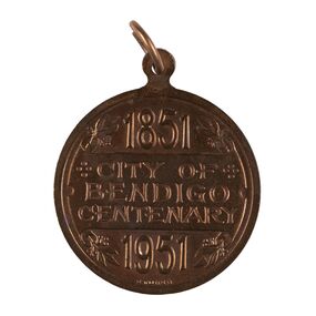 City of Greater Bendigo - Civic Collection
Medal - City of Bendigo Centenary Medal, Stokes and Son
Medal commemorating the centenary of the establishment of a settlement on Bendigo Creek. Stokes & Sonsobverse; 1851 / City of Bendigo Centenary / 1951. Reverse: In centre: Coat of arms (Bendigo), Below Progresscity of greater bendigo medals -
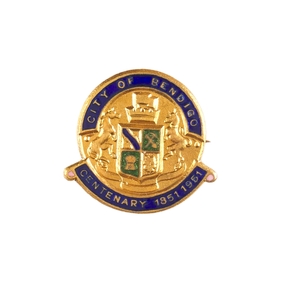 City of Greater Bendigo - Civic Collection
Decorative object - City of Bendigo Centenary decorative pin, Stokes and Son, 1951
Medal commemorating the centenary of the establishment of a settlement on Bendigo Creek. (.1) Small, circular, gold pin with blue and green enamel. below. (.2) Seventeen numbered paper envelopes containing single pin.Face of pin has the City of Bendigo Coat of Arms in relief with 'City of Bendigo' above and 'Centenary 1851 - 1961' city of greater bendigo medals -
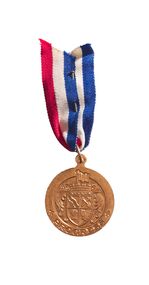 City of Greater Bendigo - Civic Collection
Medal - City of Bendigo Centenary Medal with ribbon, Stokes and Son
Medal commemorating the centenary of the establishment of a settlement on Bendigo Creek. Stokes & Sons pressed medal with gold finish to commemorate the 100th anniversary of the establishment of Bendigo. obverse; 1851 / City of Bendigo Centenary / 1951. Reverse: In centre: Coat of arms (Bendigo), Below Progresscity of greater bendigo medals -
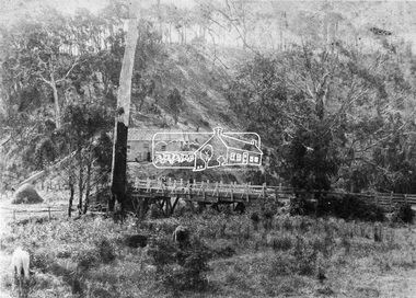 Eltham District Historical Society Inc
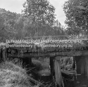
Negative - Photograph, Hurst's Bridge, 1885
Looking northwest onto the first bridge at Hurstbridge, 1885. The area of Hurstbridge was originally known as Hurst’s-bridge after the timber bridge built over the Diamond Creek near Hurst’s station in late 1881/early 1882 on the Hurstbridge-Arthurs Creek Road, Hurstbridge. It was built by John McDonald, of Arthur's Creek and was demolished and replaced in 1917 by a reinforced concrete arch bridge designed by John Monash. Cross Reference Photo No.(s): 1012/1013This photo forms part of a collection of photographs gathered by the Shire of Eltham for their centenary project book,"Pioneers and Painters: 100 years of the Shire of Eltham" by Alan Marshall (1971). The collection of over 500 images is held in partnership between Eltham District Historical Society and Yarra Plenty Regional Library (Eltham Library) and is now formally known as the 'The Shire of Eltham Pioneers Photograph Collection.' It is significant in being the first community sourced collection representing the places and people of the Shire's first one hundred years.Digital image 4 x 5 inch B&W Negshire of eltham pioneers photograph collection, hurstbridge, bridge, diamond creek (creek), hurst's bridge -
 City of Moorabbin Historical Society (Operating the Box Cottage Museum)
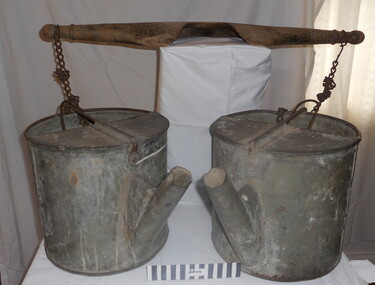
Tool - Chinese Market-Gardener's Watering-Cans
... creeks ...Chinese market-gardener’s watering-cans on a wooden yoke. This item was authenticated by the Bendigo Historical Society, and is said to be quite rare. It consists of two large galvanized watering-cans each with a pouring spout, suspended by chains from a well-used wooden yoke. The cans would each have been filled with water, then carried a distance into the market garden and used to water crops. The cans and yoke alone are very heavy, one can only imagine how heavy they were when filled with water.As profits from the gold-fields petered out the Chinese immigrants, (nearly all single men), were forced to seek other occupations. Many moved into furniture building in the East Melbourne area, whilst others went into market gardening . A significant number of Chinese men, realising the potential of the sandy, fertile soil, with a good supply of water, in the Shire of Moorabbin, leased tracts of land in that area to establish a market garden and grow produce for the increasing population of MelbourneAfter the Dendy Special Survey in1841in Brighton, Victoria, the first sale of Crown Land, taking in the whole Shire of Moorabbin, occurred in 1852. These allotments of land were eagerly bought up - some by speculators - although many were either worked by the owner, or leased out as market gardens and "fruit gardens", (orchards). Chinese market-gardener’s watering-cans suspended by chains on a wooden yoke. This item was authenticated by the Bendigo Historical Society, and is said to be quite rare. It consists of two large galvanized watering-cans each with a pouring spout, suspended by chains from a well-used wooden yokebrighton, gardeners, bentleigh, orchards, vegetables, dendy henry, market gardens, chinese settlers, pioneers moorabbin, water wells, creeks -
 Falls Creek Historical Society
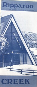
Booklet - Ripparoo Lodge, 1973
Ripparoo Lodge was one of the earliest Lodges established in the Falls Creek Village. In the 1960s, Bob and Noelene Lee moved to Falls Creek to run Ripparoo Lodge. They later built Attunga Ski Lodge. Both of these lodges still operate successfully in the 2020s.This brochure is significant because it represents one of the early lodges at Falls Creek. A fold out brochure printed in blue and white, it include some images and cartoons of people enjoying hospitality at Ripparoo. Information on tariffs and services is included.Title - Ripparoo The happiest ski lodge in the village.falls creek accommodation, ripparoo, falls creek lodges -
 Falls Creek Historical Society
Photograph - Man made ski jump at Falls Creek 1961
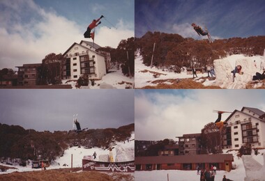
Julian Newton-Brown arrived at Falls Creek in 1957. He had studied Pharmacy at Melbourne University. After developing a love for the mountains, Julian moved to Mt. Beauty and then Falls Creek. He worked for the SEC in the test laboratory at Rocky Valley reading weather instruments. By working several jobs, Julian was able to build a small lodge of 10 beds named “Arundel”, located at 18 Slalom Street, Falls Creek. The lodge is now the “Elk at Falls”. Arundel prospered and Julian extended it to include 32 beds and changed its name to "Julian’s” in 1961. When alcohol restrictions were eased in Falls Creek, Julian built a night club which he called “Big Julian’s” and later “THE MAN”. When Julian and his wife Beth retired and left Falls Creek, their son took over running the lodge. An active community man, Julian was a member of the Falls Creek Chamber of Commerce, a member of the SES, a stakeholder in Falls Creek, an author and a documentary maker. Julian Newton-Brown died in May 2020. The ski jump was built by Julian Newton Brown and Nick Popov near Diana Lodge. Nick Popove and his wife Jean can be seen on the far right in the black and white image.This item is significant because it gives details of an important lodge at Falls Creek, Victoria.Photographs of action at the ski jump constructed c1960. julian's lodge, julian newton brown, falls creek ski lodges, accommodation falls creek, charlie brown -
 Falls Creek Historical Society
Photograph - Julian Newton Brown on Yamaha SL 351
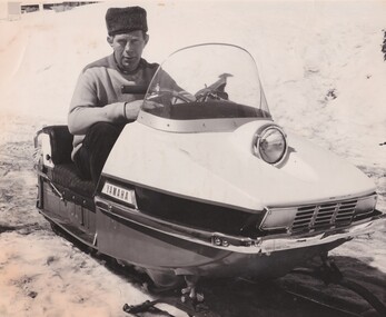
Julian Newton-Brown arrived at Falls Creek in 1957. He had studied Pharmacy at Melbourne University. After developing a love for the mountains, Julian moved to Mt. Beauty and then Falls Creek. He worked for the SEC in the test laboratory at Rocky Valley reading weather instruments. By working several jobs, Julian was able to build a small lodge of 10 beds named “Arundel”, located at 18 Slalom Street, Falls Creek. The lodge is now the “Elk at Falls”. Arundel prospered and Julian extended it to include 32 beds and changed its name to "Julian’s” in 1961. When alcohol restrictions were eased in Falls Creek, Julian built a night club which he called “Big Julian’s” and later “THE MAN”. When Julian and his wife Beth retired and left Falls Creek, their son took over running the lodge. An active community man, Julian was a member of the Falls Creek Chamber of Commerce, a member of the SES, a stakeholder in Falls Creek, an author and a documentary maker. Julian Newton-Brown died in May 2020. In 2003 when this flyer was published operation of Julian's Lodge transferred from Julian and his wife Beth to their son Charlie Brown, a former Australian Champion and World Cup skier and his wife, Bena.This item is significant because it gives details of an important lodge at Falls Creek, Victoria.A black and white image of Julian Newton Brown testing a Yamaha SL 351 in 1968.julian's lodge, julian newton brown, falls creek ski lodges, accommodation falls creek, charlie brown