Showing 13591 items
matching wye-river-bridge
-
 City of Moorabbin Historical Society (Operating the Box Cottage Museum)
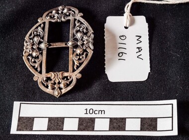
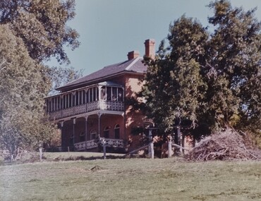
Manufactured Object, 1 x square/ oval white metal buckle, c1900
c1900 Decorative silver, pewter or brass buckles were attached by ribbons or straps to plain shoes for evening and special occasions . This buckle was worn by a lady in the family of Ailsa Hunt in Moorabbin ShireThis decorative shoe buckle was a common accessory for early settler women in Moorabbin Shire c1900 An oval white metal shoe buckle with filigree and 2x central square spaces bridged by a bar Bridging bar : Made in Francefootwear, shoes, buckles, clothing, silver, pewter, brass, victorian fashion, edwardian fashion, market gardeners, early settlers, moorabbin shire, bentleigh, mckinnon, moorabbin, cheltenham, wedding dresses, evening wear, -
 Tatura Irrigation & Wartime Camps Museum
Note Pad, pre 1990
used prior to privatisation in 1990State Rivers and Water Supply Commission issue foolscap size pad for correspondence. 21 sheets remaining.State Rivers and Water Supply Commission Memorandum victoria state rivers and water supply commission -
Glenelg Shire Council Cultural Collection
Photograph - Photograph - Bridge Construction, 02/12/1957
Port of Portland Authority ArchivesFront: Back- 'Finn Street Bridge view to south west of completed bridge' - black pen 2/12/1957port of portland -
 Melbourne Tram Museum
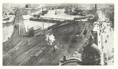
Photograph - Yarra River from Flinders St Station clock tower, Town and Country Journal, 1909
Photos show the Yarra river and the shipping turning basin that was used prior to the construction of the Spencer St bridge. In the view are are steam hauled suburban trains, Flinders St A signal box, Queensbridge, and the wharves on either side of the river. The viaduct was expanded to four tracks in 1915. Yields information about Yarra River, Flinders St railway station yards and shipping,Set of two photographs looking west from the Flinders St Station clocktower. over the Yarra River and station yards.On rear of both prints in ink: 1 – Melbourne - West from clock tower on Flinders St station - “Town and Country Journal 21/7/1909” Copy neg Mark Plummer collections ex late John Alfred collection. .2 - Melbourne, Looking west along Flinders St from clocktower of Flinders St station. Copy neg Mark Plummer collections ex late John Alfred collection. Has “T&C 20/12/09” in pencil on rear. bridges, flinders st station, yarra river, wharves, railways, signal boxes, queens bridge, shipping -
 Port of Echuca
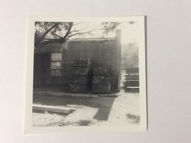
Black and white photograph, Approx. 1975
The old brick Murray River Sawmill office was demolished around 1975. This appears to be part of one of the office buildings associated with the sawmill, taken in shadow, with the building well back on the block, on the bridge side. There is a dirt driveway in front of the building and stacks of timber next to the chimney side of the building. Trees are visible behind these stacks of timber. Two stacks of timber (1x 4 blocks high, 1 X 3 blocks high) are in front of the building between the window and the chimney This relates to photographs P000106, P000105 Sawmills in the Echuca area were historically and socially significant being a large employer in the area. The Murray River sawmill was one of the biggest and longest operating sawmills in the area. Black and white photograph of an old Murray River Sawmill building with the chimney to the right and a door and window on the left. Two stacks of timber planks are against the wall between the window and the chimney. A dirt driveway is in front of the building with timber planks edging the driveway.On the reverse in pencil "Old M. R. S. Building well back on the block on the bridge side. Near old offices, also demolished about 1975??" Kodak, , in blue ink "0932"murray river sawmills, echuca, echuca, victoria, pullicino, j (unconfirmed) -
 The Beechworth Burke Museum Research Collection
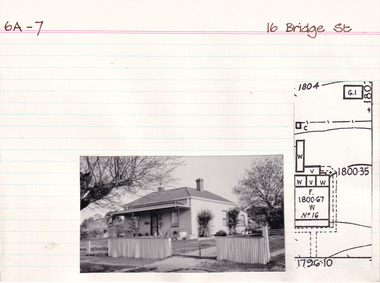
Card (Series) - Index Card, George Tibbits, 16 Bridge Street, Beechworth, 1976
George Tibbits, University of Melbourne. Faculty of Architecture, Building and Town & Regional PlanningIndex system that support the research for Beechworth : historical reconstruction / [by] George Tibbits ... [et al]Arranged by street names of BeechworthEach index card includes: street name and number of property, image of property, allotment and section number, property owners and dates of ownership, description of the property according to rate records, property floor plan with dimensions.beechworth, george tibbitsbeechworth, george tibbits -
 Wodonga & District Historical Society Inc
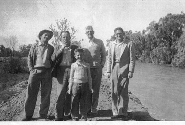
Album - Ringer's River by Des Martin - Settings
Image 1: "de KERILLEAU" - Alongside Wodonga, home of the Watson family, was built by Charles Huon de Kerilleau, founder of the Wodonga Run. Huon took up his country in 1836, living then about 13 miles from the present homestead, the front portion of which was built about 1870. The actual age of an earlier portion is not known. Excellent for "Barmagulla". Image 2: "THE HERMITAGE" - Home of the Taylor family, is 13 miles from Wodonga. It was begun in 1852 and finished in 1854, and is the oldest occupied home in the area. The original atmosphere of the interior is maintained. As "Gooloora" its little balcony would provide a splendid vantage point for MacLough's speech. Image 3: Murray River Country above Granya, Victoria Image 4: Looking over Murmungee from the Buckland Gap near Beechworth, VictoriaThe album and images are significant because they document literature written by a prominent member of the Wodonga community. The presentation of this precis was supported by several significant district families and individuals.Coloured photos of venues suggested as settings for filming of the series. des martin, many a mile, ringer's river, northeast victoria stories -
 Phillip Island and District Historical Society Inc.
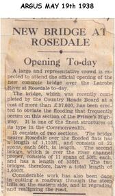
Newspaper clippings, 19/05/1938
Newspaper article in The Argus 19/08/1938Article on opening of new bridge over the Latrobe River at Rosedale.local history, documents, newspapers, bridges, rosedale, latrobe river, black & white newspaper clipping -
 Bendigo Historical Society Inc.
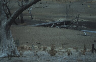
Slide - VAL DENSWORTH COLLECTION: DRY LAKE EPPALOCK, May 2004
Slide. Dry Lake Eppalock. A low bridge over the river.slide, bendigo, dry lake eppalock., dry lake eppalock. -
 Bendigo Historical Society Inc.
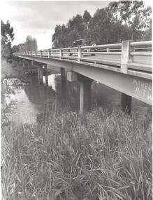
Photograph - PHOTOGRAPH. ELMORE. BRIDGE OVER CAMPASPE RIVER, 1993
Photograph. Elmore. Vehicle passing on bridge over Campaspe River. -
 Bendigo Historical Society Inc.
Photograph - 'MARYDALE' AXEDALE COLLECTION: PHOTOGRAPH DRY CREEK BED
Photograph.View of dry river bed, probably Campaspe River, Axedale, with open land with bridge crossing, at ''Marydale'', Axedale.axedale, history, marydale property -
 Eltham District Historical Society Inc
Photograph, Tess Justine (Nillumbik Shire Council), Construction work on replacement of Murray's Bridge over the Diamond Creek, Eltham North, 31 Mar 2022
Construction work on replacement of Murray's Bridge over the Diamond Creek on the Diamond Creek Trail Mary (Sweeney) Murray and John Wright Murray selected 80 acres, Lot C Section 16 and Lot 5 Section 17 Parish of Nillumbik, under an occupation license in 1866. John died in 1867 and freehold was granted to his son John in 1873. The farm was known as ‘Laurel Hill’. John Junior was an Eltham Shire councillor and sometime president from 1887 up until 1897. He added Lot A Section 16 to the farm in ca1888. John and his younger brother James arranged to rent/purchase Lot B Section 17, across Diamond Creek to the west, in ca1900. It appears that John and James farmed separately for a few years, with a new homestead built for James ad family on the high point of Lot B Section 17 in ca1910. John sold off Lot 5 Section 17 in 1912. When John died in 1912 James took over the land on both sides of the Diamond Creek. The old homestead on the west side of the Creek disappeared. A farm bridge over Diamond Creek from this period may have been located close to the northern boundary of the farm. John Langlands, owner of the farm known as ‘Ihurst’ on the west side of Diamond Creek to the south of the Murray’s land, died in 1907. In 1909 his land was then subdivided into 100 lots to become the ‘Glen Park Estate’. Other similar subdivisions of nineteenth century farms around Eltham in this period included the ‘Franktonia (or Beard’s) Estate’ to the northeast and ‘Bonsack’s Estate’ between Eltham and Greensborough. Soon after the opening of the railway extension line from Eltham to Hurstbridge in 1912, Glen Park and nearby residents including James Murray agitated for a railway station or siding to be located half-way between Eltham and Hurstbridge, so that the Glen Park residents who used the railway daily did not have to walk into the Eltham or Hurstbridge stations. Some believed Coleman’s Corner (opposite Edendale Farm) was an appropriate spot for the platform. James Murray was among those who thought the railway should be located on his land, closer to half-way between Eltham and Hurstbridge stations. The Railways Commissioners warned that the locals would have to fund these works themselves. The Glen Park Estate residents initially had difficulty accessing Eltham by road, with only an old low-level bridge over Diamond Creek at the south end of their estate. A new timber trestle bridge across the creek, now on Wattletree Road, was opened in 1915. Road access to the north was gained in 1927 when the new Murray’s Road, which crossed the Murray’s land, was built. Residents continued to agitate for a Glen Park station. By 1926 the Railways Commissioners’ preferred site was on the Murray’s land. They arranged an estimate of cost of a full-length platform. The estimate was too much for the locals, who in 1928 argued unsuccessfully for a shorter and hence cheaper platform. By 1929 Murray had agreed to donate the land, but the locals would still have to fund the works. Murray decided, unilaterally it would appear, to commence work on a timber trestle road bridge over Diamond Creek to link the new Murray Road to the proposed station. Late in 1929 he stopped work on the bridge, for reasons unknown, but started work again and completed the bridge in 1931. There is no further newspaper evidence of the campaign for the Glen Park station until 1939, when Murray and another local, Mr Maxwell, met the Railways Commissioner. The Glen Park locale now included 45 homes on the west side of the creek and 20 on the Eltham side. Most of the residents used the train every day. The Commissioner remained adamant that only a full-length platform could be built for safety reasons. It appears the campaign dissolved at this point. The increasing move to cars may have had an impact. There is no evidence of Murray’s bridge ever being connected to Murray’s Road, or of it having wide use for any purpose by locals. James Murray died in 1947 and the farm was taken over by his son James (Jim). Jim started to sell off parts of the farm in the 1980s, retaining a few acres around the ca1910 homestead and building a new house there. Recreation reserves were established along the creek. In ca1990 Murray’s bridge was renovated with steel girders as part of a bike/pedestrian path in the reserve. The old farmhouse was demolished in ca2014. Born digital image (5)diamond creek (creek), diamond creek trail, murrays bridge, ‘laurel hill’, john wright murray, mary (sweeney) murra, john murray jnr, james murray, john langlands, ‘ihurst’, ‘glen park estate’, beard's estate, franktonia, bonsack's estate, glen park estate, glen park railway station -
 Eltham District Historical Society Inc
Photograph, The Batman Tree; heirloom apple tree purchased by John Batman and planted by Mr Frederick Flintoff in 1838 in the orchard of Mr Bosch, near Greensborough, now a small river flat near the Maroondah aqueduct crossing, Plenty River Walk, Greensborough, c.1989, 1989c
Colour photograph originally located in a magnetic style album titled 'Greensborough Bypass 1990s 5' suffering significant degradation. No information contained in album or on reverse of photos except where noted. Relocated to archival photosafe storage.greensborough, plenty river walk, maroondah aqueduct, batman apple tree -
 Eltham District Historical Society Inc
Photograph, Marjorie North, Plenty River, Plenty River Trail, Montmorency flowing south behind the tennis courts and cricket/football field, 1985, 1985
Negatives supplied by Marjorie North 1 July 1986 for Montmorency France albumRoll of 35mm colour negative film, 3 stripsKodak CL 200 5093montmorency, plenty river, plenty river trail -
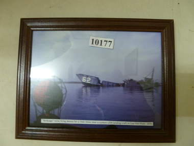 National Vietnam Veterans Museum (NVVM)
Photograph, Birdcage mining and firing device for a river mine near sunken USN landing craftCua Viet river 1970
Colour photo of mine devicecolour photo -
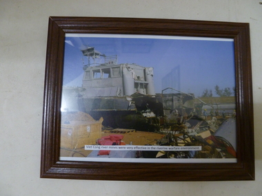 National Vietnam Veterans Museum (NVVM)
Photograph, Vietcong river mines were very effective in the river warfare environment
Colour photo of Vietcong mine damagephotograph, colour -
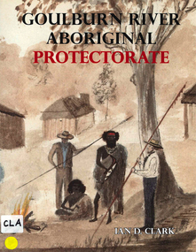 Victorian Aboriginal Corporation for Languages
Book, Ian D Clark, Goulburn River Aboriginal Protectorate : a history of the Goulburn River Aboriginal Protectorate Station at Murchison, Victoria, 1840 - 1853, 2013
This study explains why the locality of what is now known as Murchison is one of the most important historic Aboriginal places in regional Victoria.maps, b&w illustrations, b&w photographs, document reproductionsngurai-illam balug, ngurai-illam wurrung, daungwurrung, yaithmathang, yortayorta, yorta yorta, bangerang, murchison, murnang, george augustus robinson, goulburn river aboriginal protectorate, goulburn river region, victorian history -
 Wonga Park Community Cottage History Group
Photograph (sub-item) - Black and White, A view of the Yarra River from Wonga Park in 1929. [Mt Lofty in background, house is Mr. Witton’s ‘Crooning Waters’ at the confluence of Brushy Creek and Yarra River and what was to become Witton’s Reserve to the right
-
 Merbein District Historical Society
Photograph, River Red Gum Tree at river Crosbie, unknown
merbein township, river red gum, trees, crosbie -
 Merbein District Historical Society
Photograph, Murray River flood River Road, 1956
-
 Orbost & District Historical Society
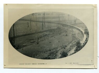
black and white photograph, Vogt. W.S, first half 20th century
In 1912 work was underrway on the Bairnsdale to Orbost railway. It was opened on April 10 1916. The two bridges on the railway viaduct, which crosses the Snowy River floodplain at Orbost, were built from local Southern Mahogany. The bridge on the Bairnsdale end (770m) is now the longest in Victoria. (info. Helen Martin)This item is associated with the history of the Orbost-Bairnsdale railway line and therefore reflects the role that the rail line played in the social and economic history of Orbost.A black / white photograph, oval-shaped on white background. It is of the railway viaduct across the flats at Orbost,.photo caption -"ORBOST RAILWAY BRIDGE, NEWMERELLA E. S. Vogt, Bairnsdale"newmerella orbost-viaduct east-gipsland-railway -
 The Beechworth Burke Museum Research Collection
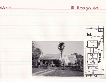
Card (Series) - Index Card, George Tibbits, 18 Bridge Street, Beechworth, 1976
George Tibbits, University of Melbourne. Faculty of Architecture, Building and Town & Regional PlanningIndex system that support the research for Beechworth : historical reconstruction / [by] George Tibbits ... [et al]Arranged by street names of BeechworthEach index card includes: street name and number of property, image of property, allotment and section number, property owners and dates of ownership, description of the property according to rate records, property floor plan with dimensions.beechworth, george tibbitsbeechworth, george tibbits -
 Eltham District Historical Society Inc
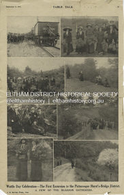
Magazine Article, J.E. Barnes, Wattle Day Celebration - The First Excursion to the Picturesque Hurst’s-Bridge District; A few of the blossom gatherers; Table Talk, September 5, p23, 1912
The September 5, 1912 issue of Table Talk celebrated "Wattle Day" where new plantings are made of the national flower and featured images from both Melbourne as well as the first excursion to Hurstbridge. Those from Hurstbridge were photographed by notable WW1 photographer, J.E. Barnes. Also digitised and accessible via National Library of Australia Trove website - (1912, September 5). Table Talk (Melbourne, Vic. : 1885 - 1939), p. 23. Retrieved July 28, 2024, from http://nla.gov.au/nla.news-page17413107 See an article on reflections about Wattle Day on page 29 - SOME REFLECTIONS UPON WATTLE DAY. (1912, September 5). Table Talk (Melbourne, Vic. : 1885 - 1939), p. 29. Retrieved July 28, 2024, from http://nla.gov.au/nla.news-article146180986 The inaugural Hurstbridge Wattle Day Festival was held Saturday, September 1, 1912 when a specially commissioned train brought 1,000 visitors to the district to enjoy the splendour of the wattle in bloom. “Melbourne’s first “Wattle Day” Campaign, the day when Australia’s national flower was to be all pervading in the streets of the metropolis, and sold in sprigs and bunches by hundred of lady volunteers, for purposes of charity, was not blessed with happy climatic conditions on Monday [2 Sep 1912]” - WATTLE DAY. (1912, September 7). Leader (Melbourne, Vic. : 1862 - 1918, 1935), p. 39. Retrieved July 28, 2024, from http://nla.gov.au/nla.news-article198116738 “In connection with Wattle Day celebrations a special train conveyed a thousand people to Hurst's-Bridge last Saturday afternoon [1 Sep 1912]. Lengthy reports of the excursion appeared in the daily papers last Monday. - WATTLE DAY. (1912, September 6). Evelyn Observer and Bourke East Record (Vic. : 1902 - 1917), p. 2 (MORNING.). Retrieved July 28, 2024, from http://nla.gov.au/nla.news-article60656027 See a review of the excursion to Hurst’s-Bridge - HURST'S-BRIDGE EXCURSION. (1912, September 2). The Age (Melbourne, Vic. : 1854 - 1954), p. 9. Retrieved July 28, 2024, from http://nla.gov.au/nla.news-article196255907 The excursion to Hurst’s-Bridge was considered such a success that the Railway department arranged to run another special train to the station on Saturday, October 5, 1912 - HURST'S-BRIDGE EXCURSION. (1912, October 2). The Age (Melbourne, Vic. : 1854 - 1954), p. 10. Retrieved July 28, 2024, from http://nla.gov.au/nla.news-article203325447Inaugural Hurstbridge Wattle Day Festival held 1 September 1912d3-class steam locomotive, hurstbridge wattle festival, special train, tait train, tourism, wattle day campaign, wattle day festival, david smyth collection -
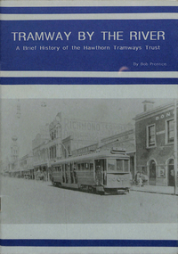 Melbourne Tram Museum
Book, Bob Prentice, Peter Bardho, "Tramway by the River - a brief history of the Hawthorn Tramways Trust", 1993
Book - 16 pages printed on off white paper plus light card cover printed on grey paper, titled "Tramway by the River - a brief history of the Hawthorn Tramways Trust". Originally written by Bob Prentice in a TMSV Running Journal of 1966 (Vol. 2 No. 4), then to a booklet by Peter Bardho of Tramway Publications in 1993. Covers the history of the trust, those involved, horse tram, operations, Riversdale Road extension, mileage, track layout with plans, overhead, rollingstock, the Burwood accident of Jan. 1917, depot, substation, Wattle Park, employees strike, fares and sections, annual balance sheets, timetables, rolling stock data, disposal and an epilogue following the establishment of the MMTB. Has numerous photos. 2nd Edition, published by Tramway Publications 2016, Edited by Dean Filgate - digital image added 7/8/2020 as htd1117i2.pdf.trams, tramways, htt, burwood, accidents, depot, hawthorn, tramcars, tmsv, wattle park, employees -
NMIT (Northern Melbourne Institute of TAFE)
Set of photographs: Tony Yeates Sydney Harbour Bridge [1998]
3 Sets held numbered 106, 989 and 990.A series of duotone printS of Sydney Harbour Bridge housed in a hand-made portfolio, bound in the traditional method. Produced probably in 1998. Intended for presentations from NMIT. From National Library of Australia record 'Limited to 1000 prints, increasing in value as the edition is sold out, "The prints are colour calibrated for display under tungsten lighting. They are individually numbered, embossed and placed between acid free trace paper to help protect the prints surface".tony yeates, sydney harbour bridge, presentation pieces, nmit -
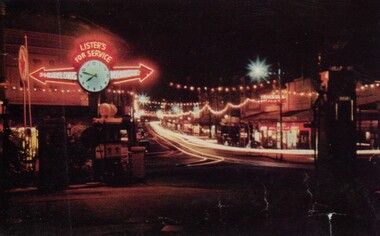 Ballarat Tramway Museum
Photograph - Digital image, looking west along Bridge St Ballarat with the lighting provided for the Royal Visit, 1954
Yields information about the appearance of Bridge St festoon lighting for the 1954 Royal Visit and Begonia Festival. Has a strong association with the Garage on the corner of Bridge St and Main Road.Digital Copy of a photograph sourced by Roger Greenwood as part of his work on the production of a Video Tape on Ballarat's trams. Photographer and source details not provided by Roger. See btm6304doc.pdf Image looking west along Bridge St Ballarat with the lighting provided for the Royal Visit and Begonia Festival 1954. Has the Lister's Garage sign providing directions to Melbourne and Geelong with a clock centrally mounted. Also has a Caltex sign. Photo from a postcard. trams, tramways, bridge st, stones corner, main road, royal visit, begonia festival -
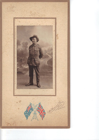 Emerald Museum & Nobelius Heritage Park
Photograph, Nightingale/Thompson Collection, c 1914 - 1918
Photograph of young man in service uniform, identity: Victor George Thomson (1894 - 1948). Victor was the son of William Samuel Thompson and Elizabeth Alice Bishop. Victor was born in GembrookThompson CollectionSepia photograph of soldier on board with coloured flag logo of an embossed coat of armsMakers marks: coloured flags - Australia and UK with W Mason & Co 144 Bridge Road Richmond, Melbourne embossed Australian coat of Arms and embossed bows on top and bottom of photo. Inscription on back: Victor Thompson, my cousinthompson collection, nightingale -
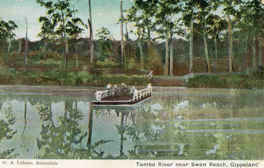 Lakes Entrance Historical Society
Postcard - Swan Reach Punt, Lidston, 1895
Coloured copy of a postcard of a punt over the Tambo River near Swan Reach, Victoria. Four people on the punt.Tambo River near Swan Reach Gippsland waterways, transport -
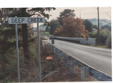 Sunbury Family History and Heritage Society Inc.
Photograph, Bulla, C 1980s
The photograph shows the approach to the Bulla Bridge at Deep Creek in the Township of Bulla. Immediately on crossing the bridge there is a sharp bend in the road and a step ascent up Bulla Hill through the cutting until level ground is reached. The photograph is looking to the NW. Deep Creek meets the Maribyrong River further downstream and closer to Keilor.The bridge and road replaced the ford crossing in 1869 that was downstream from the bridge.A coloured photograph of the approach to a bridge over the Deep Creek at Bulla along Sunbury Road. bulla bridge, deep creek, sunbury road -
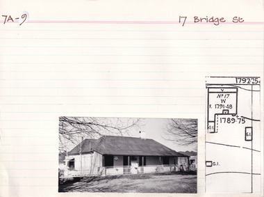 The Beechworth Burke Museum Research Collection
Card (Series) - Index Card, George Tibbits, 17 Bridge Street, Beechworth, 1976
George Tibbits, University of Melbourne. Faculty of Architecture, Building and Town & Regional PlanningIndex system that support the research for Beechworth : historical reconstruction / [by] George Tibbits ... [et al]Arranged by street names of BeechworthEach index card includes: street name and number of property, image of property, allotment and section number, property owners and dates of ownership, description of the property according to rate records, property floor plan with dimensions.beechworth, george tibbitsbeechworth, george tibbits