Showing 7021 items
matching eltham road
-
 Eltham District Historical Society Inc
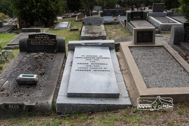
Photograph, Peter Pidgeon, Grave of John Arthur and Grace Mitchell, Eltham Cemetery, Victoria, 5 April 2021
... and Main roads, Eltham in the 1950s. Shortly after her marriage...Mount Pleasant Road, Eltham, Victoria, Australia... and Main roads, Eltham in the 1950s. Shortly after her marriage ...Grace Mitchell, a talented artist in later life and baker, managed a pastry shop business near the corner of Mount Pleasant and Main roads, Eltham in the 1950s. Shortly after her marriage to Arthur Mitchell in 1948, Arthur incurred a head injury from an accident and was unable to work. Grace realised she needed to be home to care for her husband as well as earn an income. She managed the bureaucracy of council permits, and made modifications to her home with savings to get the business off the ground without having to borrow money. Grace and Arthur were avid gardeners and would grow, wash and mince vegetables for pasties while Grace handmade and rolled the pastry. They cooked and minced their own meat for the pies and the fruit for the sweet pies came from their orchard at the rear of the property. She also baked scones and cakes. With weekend visitors travelling to Eltham on the train for days trips, her reputation grew as the spot for afternoon tea. Grace’s daughter Jenni mentions the visit of dancer, Robert Helpmann and U.S. actress Katherine Hepburn in her Grace Mitchell: a short history [2012]. Reminiscences in We did open a school in Little Eltham: Eltham Primary School 209, 1856-2006 a history [2006] include a mention of Grace’s famous pastry shop and the Sunday afternoon visit by Helpmann and Hepburn. Grace operated her pastry shop for over 16 years. She supported the Shillinglaw Cottage Preservation Campaign to preserve the cottage through its Flavour of Eltham community cookbook published in 1964 and hosted cooking classes in the new Living and Learning Centre. Grace Mitchell passed away aged 95 years in 2011. In memory of John Arthur Mitchell 1905 – 1975 And Grace Mitchell 1916 – 2011 Loving parents of Jennifer MitchellBorn Digitaleltham cemetery, gravestones, grace mitchell, john arthur mitchell -
 Eltham District Historical Society Inc
Photograph, Peter Pidgeon, Grave of John and Mary Murray, Eltham Cemetery, Victoria, 5 April 2021
... to slightly past Wattletree Road. Eltham North Reserve now lies just...Mount Pleasant Road, Eltham, Victoria, Australia... to slightly past Wattletree Road. Eltham North Reserve now lies just ...Irish-born John Murray and his wife Mary (daughter of Thomas Sweeney) married in 1849 and settled in Eltham North. John and Mary were amongst the earliest inhabitants of Eltham. John was a farmer and their block of about 80 acres, called ‘Laurel Hill’, was on the eastern side of the Diamond Creek, extending east to beyond Zig Zag Road. It was later extended southward by the purchase of a further 60 acres. He is recorded as a supporter on the petition for a school in Eltham and he served on the National School Board of the Eltham school. John died in 1867 and is buried in Eltham Cemetery with Mary and with two of their grandchildren. Their eldest son Johnnie inherited the property. Then in about 1902 his younger brother James purchased about 50 acres on the western side of the Diamond Creek immediately opposite Laurel Hill, extending west to slightly past Wattletree Road. Eltham North Reserve now lies just beyond the southern boundary. James built a family home on top of the hill on the northern boundary, together with a dairy and milking shed and a food cellar. It is thought that the barn with stables was already there. When Johnnie died in 1912, the two properties (though severed by both the creek and the railway line) effectively merged. The land was worked as an orchard with apples, pears, quinces, and possibly apricots and peaches. Later it became a dairy farm. By 1986, almost all the land had been sold off for residential subdivision and the house had been condemned as unfit for habitation. John's grandson Jim retained a small portion of the land and built a new house. He kept the old one as a storage shed, but it was demolished after he died in 1993. The very old barn is still standing. Located in the Roman Catholic section In Memory of John Murray Who died Dec. 1867 aged 50 years Also his wife Mary Murray Who died 7th Sep. 1909 aged 76 years And of their grandchildren Thomas and Mary Ellen DrainBorn Digitaleltham cemetery, gravestones, john murray, mary ellen drain, mary murray, thomas drain -
 Eltham District Historical Society Inc
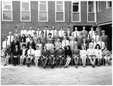
Photograph, Hugh Fisher, Eltham Shire Council Staff, Shire Centenary Anniversary, 6 April 1971
... by the Shire of Eltham, to commemorate the Shire Centenary April 1971...895 Main Road, Eltham, Victoria...Eltham District Historical Society Inc 728 Main Rd Eltham ...Formal photograph of group of men and women employed by the Shire of Eltham, to commemorate the Shire Centenary April 1971. Photograph taken at the rear of the Council Offices, Main Road, Eltham Includes Eltham Shire Council Staff List and Phone Numbers, 1971 1971 Eltham Shire Council Staff Photo (SEPP_4050 and SEPP_4051) L-R Back Row: N. Stuart (Engineering), N. Campbell (Engineering), W. Oakley (Engineering), R. McIldowie (Engineering), D. Welch (Engineering), G. Pullen (Accounts), J. Bleazby (Rates), P. Sturtevent (Engineering), B. Hill (Engineering), F. Harrington (Engineering) Third Row: C. Harris (Building), M. Van Ewijk (Accounts), Miss C. Casella (Administration), Miss D. Curran (Rates), M. Howard (Administration), Dennis McKay (Engineering), Mrs L. Crockett (Accounts), A. Liepa (Engineering), G. Newton (Building), Mrs N. Davis (Administration), I. Leach (Health), Mrs F. Conyers (Rates), B. Wright (ranger), I. Caig (Traffic By-Laws Officer) Second Row: J. Constable (Accounts), J. Parsons (Health), Mrs J. Baker (Health), P. Hoare (Engineering), Miss R. Spearman (Rates), D. Golder (Engineering), Mrs R. Cox (Administration), H. Masefield (Fire Proper Officer), A. Birch (Engineering), Sister L. Cameron (Health), Russell Yeoman (Engineering), T. Phyland (Engineering) Front Row (seated): Miss D. Vreulink (Administration), D. Lovatt (Health), Mrs H. Dixson (Accounts), M. Fowler (Rates), Mrs L. Harris (Administration), C. Gaudion (Health), M. Watson (Shire Secretary), A. Roberts (Administration), Miss J. Featherby (Engineering), M. Verhoeven (Engineering), Mrs M. Lethlean (Engineering), I. McDonald (Rate Collector), Mrs W. Klooster (Engineering), Mrs C. Bell (Engineering) Absent: John McDonald (Shire Engineer) This photo forms part of a collection of photographs gathered by the Shire of Eltham for their centenary project book,"Pioneers and Painters: 100 years of the Shire of Eltham" by Alan Marshall (1971). The collection of over 500 images is held in partnership between Eltham District Historical Society and Yarra Plenty Regional Library (Eltham Library) and is now formally known as the 'The Shire of Eltham Pioneers Photograph Collection.' It is significant in being the first community sourced collection representing the places and people of the Shire's first one hundred years.Digital image Print Foolscap page typedInscribed A2207A (SEPP_4050) 2nd version inscribed A2207B (SEPP_4051)a. birch, a. liepa, a. roberts, b. hill, b. wright, c. gaudion, c. harris, council, council staff, council-staff, d. golder, d. lovatt, d. welch, dennis mckay, eltham-shire-council, f. harrington, g. newton, g. pullen, h. masefield, i. caig, i. leach, i. mcdonald, j. bleazby, j. constable, j. parsons, john mcdonald, m. fowler, m. howard, m. van ewijk, m. verhoeven, m. watson, miss c. casella, miss d. curran, miss d. vreulink, miss j. featherby, miss r. spearman, mrs c. bell, mrs f. conyers, mrs h. dixson, mrs j. baker, mrs l. crockett, mrs l. harris, mrs m. lethlean, mrs n. davis, mrs r. cox, mrs w. klooster, n. campbell, n. stuart, p. hoare, p. sturtevent, r. mcildowie, russell yeoman, shire of eltham centenary, shire of eltham pioneers photograph collection, sister l. cameron, t. phyland, w. oakley -
 Eltham District Historical Society Inc
Photograph, Hugh Fisher, Eltham Shire Council Staff, Shire Centenary Anniversary, 6 April 1971
... by the Shire of Eltham, to commemorate the Shire Centenary 6 April 1971...895 Main Road, Eltham, Victoria...Eltham District Historical Society Inc 728 Main Rd Eltham ...Formal photograph of group of men and women employed by the Shire of Eltham, to commemorate the Shire Centenary 6 April 1971. Photograph taken at the rear of the Council Offices, Main Road, Eltham 1971 Eltham Shire Council Staff Photo (SEPP_4050 and SEPP_40511) L-R Back Row: N. Stuart (Engineering), N. Campbell (Engineering), W. Oakley (Engineering), R. McIldowie (Engineering), D. Welch (Engineering), G. Pullen (Accounts), J. Bleazby (Rates), P. Sturtevent (Engineering), B. Hill (Engineering), F. Harrington (Engineering) Third Row: C. Harris (Building), M. Van Ewijk (Accounts), Miss C. Casella (Administration), Miss D. Curran (Rates), M. Howard (Administration), Dennis McKay (Engineering), Mrs L. Crockett (Accounts), A. Liepa (Engineering), G. Newton (Building), Mrs N. Davis (Administration), I. Leach (Health), Mrs F. Conyers (Rates), B. Wright (ranger), I. Caig (Traffic By-Laws Officer) Second Row: J. Constable (Accounts), J. Parsons (Health), Mrs J. Baker (Health), P. Hoare (Engineering), Miss R. Spearman (Rates), D. Golder (Engineering), Mrs R. Cox (Administration), H. Masefield (Fire Proper Officer), A. Birch (Engineering), Sister L. Cameron (Health), Russell Yeoman (Engineering), T. Phyland (Engineering) Front Row (seated): Miss D. Vreulink (Administration), D. Lovatt (Health), Mrs H. Dixson (Accounts), M. Fowler (Rates), Mrs L. Harris (Administration), C. Gaudion (Health), M. Watson (Shire Secretary), A. Roberts (Administration), Miss J. Featherby (Engineering), M. Verhoeven (Engineering), Mrs M. Lethlean (Engineering), I. McDonald (Rate Collector), Mrs W. Klooster (Engineering), Mrs C. Bell (Engineering) Absent: John McDonald (Shire Engineer) This photo forms part of a collection of photographs gathered by the Shire of Eltham for their centenary project book, "Pioneers and Painters: 100 years of the Shire of Eltham" by Alan Marshall (1971). The collection of over 500 images is held in partnership between Eltham District Historical Society and Yarra Plenty Regional Library (Eltham Library) and is now formally known as 'The Shire of Eltham Pioneers Photograph Collection.' It is significant in being the first community sourced collection representing the places and people of the Shire's first one hundred years.Digital image Print 20 x 25 cmInscribed A2207A (SEPP_4050) 2nd version inscribed A2207B (SEPP_4051)a. birch, a. liepa, a. roberts, b. hill, b. wright, c. gaudion, c. harris, council, council staff, council-staff, d. golder, d. lovatt, d. welch, dennis mckay, eltham-shire-council, f. harrington, g. newton, g. pullen, h. masefield, i. caig, i. leach, i. mcdonald, j. bleazby, j. constable, j. parsons, john mcdonald, m. fowler, m. howard, m. van ewijk, m. verhoeven, m. watson, miss c. casella, miss d. curran, miss d. vreulink, miss j. featherby, miss r. spearman, mrs c. bell, mrs f. conyers, mrs h. dixson, mrs j. baker, mrs l. crockett, mrs l. harris, mrs m. lethlean, mrs n. davis, mrs r. cox, mrs w. klooster, n. campbell, n. stuart, p. hoare, p. sturtevent, r. mcildowie, russell yeoman, shire of eltham centenary, shire of eltham pioneers photograph collection, sister l. cameron, t. phyland, w. oakley -
 Eltham District Historical Society Inc
Photograph, Doug Orford, Completion of bridge works across Yarra River at rear of Eltham Lower Park, July 2004
... -Templestowe footbridge over the Yarra River off Homestead Road, Eltham... Homestead Road, Eltham which was completed July 2004. Third... Road, Eltham which was completed in July 2004. The Yarra River ...Bitumen shared pathway under construction at the new Eltham-Templestowe footbridge over the Yarra River off Homestead Road, Eltham which was completed in July 2004. The Yarra River Footbridge was opened in August 2004 and links the Diamond Creek Trail between the Shire of Nillumbik and City of Manningham. It is a shared pathway and also links with the Main Yarra Trail. It affords lovely views over the Yarra River.Three colour photographs showing commencement of construction of Eltham-Templestowe footbridge over Yarra River off Homestead Road, Eltham which was completed July 2004. Third photograph of dedictaion plaque at opening 30 Aug 2004bridges, yarra river, eltham south, eltham lower park, lenister farm, homestead road, asphaldt, bitumen, shared pathway, diamond creek trail -
 Eltham District Historical Society Inc
Photograph, Peter Pidgeon, Grave of Richard George, Emily Ann (nee Davis) and Edith Jane Kaylock, Eltham Cemetery, Victoria, 5 April 2021
... in Eltham Cemetery with his wife Emily. His property...Mount Pleasant Road, Eltham, Victoria, Australia... coach road to Eltham and in 1922 was described as an "old rustic ...In his early adult life, Richard Kaylock worked as a whaler (visiting California and New Zealand) and later as a drover on a large cattle station in New South Wales. In 1848 he came to Melbourne, working as a slaughterman, then settled in Eltham in 1854, his occupation thereafter being variously recorded as butcher or orchardist. He also had some experiences at Ballarat during the Eureka Rebellion. He died in 1910 at the age of 84. His obituary described him as a "striking personality" who was "brusque to a fault" and "strictly upright, expecting others to be the same". It seems from his will that he was illiterate. He is buried in Eltham Cemetery with his wife Emily. His property was in Wellington Street (now Brougham Street) and apparently extended across the Diamond Creek. The land on the western side of the creek was farmed, the house being on the eastern side. For many years the Brougham Street bridge was generally known as "Kaylock's Bridge". It formed part of the original coach road to Eltham and in 1922 was described as an "old rustic bridge". Its low level and insubstantial construction made it susceptible to flood damage, necessitating frequent closures until repairs could be carried out. The original bridge was demolished in 1923 and replaced by a "new up-to-date" one. When a lack of finances delayed repairs to the Bridge Street bridge in 1931, traffic had to detour via Brougham Street for some time. Local residents feared that the Bridge Street bridge might never reopen. In Loving Memory Of Our Dear Father & Mother R.G. and E.A. Kaylock Also E.J. Kaylock Died 21st Jan. 1927 The Eternal God Is My PledgeBorn Digitaleltham cemetery, gravestones, brougham street bridge, edith jane kaylock, emily ann kaylock (nee davis), kaylocks bridge, richard george kaylock -
 Eltham District Historical Society Inc
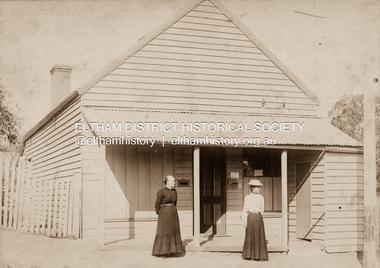
Photograph, Clark Bros, Eltham Post Office, c.1895
... Hunniford's Eltham Post Office, Main Road near Bridge... melbourne Hunniford's Eltham Post Office, Main Road near Bridge ...Hunniford's Eltham Post Office, Main Road near Bridge Street, Eltham, c.1895. Possibly Miss Anne (Annie) Hunniford, Post Mistress, on left. Annie was post mistress from the mid 1860s until her death in 1928. Photo taken by Clark Bros, 25 Thomas St, Windsor. Clark Bros operated from this address from c.1894 to 1914. Australia Post: Gold brought life to the township - Diamond Valley News, Tuesday July 2, 1985, p17 On February 1, 1854, the first Eltham Post Office was established, commencing an association between the township and the Postmaster-General's Department that has continued for 131 years. At that time, the number of permanent residents would have been fairly small, probably less than 200. The discovery of gold in June 1851, at Anderson’s Creek, some five miles away, and later at Caledonia Diggings, Queenstown (now known as St Andrews), about 14 miles to the north-east, brought large numbers of prospectors passing through the township, hopefully culling the creeks and gullies for the precious metal. This additional "floating population" brought a greater demand for supplies and for communication with the outside world, and so it helped in the development of Eltham. Today, Eltham is a thriving township. It boasts an excellent shopping centre, municipal offices, court house. post office and many other amenities. Eltham continued to develop at a leisurely pace. During 1860, a total of just over 8000 postal articles were handled at the Eltham Post Office. By 1862, the mail route was "to and from Melbourne by way of Eltham and Kangaroo Ground, three times a week, by coach". There was also a branch mail that operated between Eltham and Greensborough, three times weekly. This was also conveyed by coach. Some time between 1864 and 1868 the management of the post office passed from Thomas Hunniford to his daughter, Miss Anne Hunniford, who managed the Eltham Post Office until her death in 1928. A big improvement in communication was provided for Eltham residents when a telegraph office was established at the post office in 1877. During 1923 a manual telephone exchange was provided at Eltham, the first two subscribers being J.J. O’Connor and Eltham Police Station. In 1949 the manual exchange was replaced by an automatic exchange and there were some 150 subscribers. Following the death of postmistress Miss Anne Hunniford in 1928, B.M. Burgoyne was placed temporarily in charge of the office. In 1929, J. N. Burgoyne was appointed postmaster, and he in turn was succeeded by H. C. Burgoyne in 1951. The post office was moved to a new site in 1954, but continued under the charge of Mr Burgoyne. In January 1958 there was a further change of site when the post office was raised to official status and transferred to new premises in Main Rd. William Donoghue was acting postmaster when the new office was opened. In March 1958 Mr W.E. Tovey was appointed postmaster, followed by Douglas McG. Gilmour in 1959. William Donoghue was fully appointed in 1966 and Barry Reichelt followed in 1973, prior to the present postmaster, Peter Jolly in November 1982. Peter is a young man with 18 years' experience. He commenced his training as a postal clerk at the training school in Melbourne in 1968 and was promoted to postal clerk at the Brunswick Post Office in 1969. He was finally transferred as postmaster to Fawkner Post Office in 1980. He has been at Eltham Post Office for the past 2½ years. He is married with one child and lives in Montmorency. The Eltham Post Office employs a staff of 21, of whom seven are indoor staff, 12 are postmen and two are drivers. The postmen in Eltham have an uphill battle delivering mail because of the hilly terrain. Nine of the postmen deliver mail on motorbikes, and the two delivery vans are both four wheel drives. Eltham Post Office services basically a residential area, with deliveries to 5600 homes. This is growing at the rate of 600 homes every 18 months, i.e. about 32 homes per month. At the present rate we will need a new postman every 18 months.Sepia photograph mounted on cardpost office, eltham, main road, anne jane hunniford (1855-1928), clark bros. photo -
 Eltham District Historical Society Inc
Photograph, Baldwin Avenue, Montmorency, c.1972, 1972c
... Shire of Eltham road construction and realignment works... melbourne Shire of Eltham road construction and realignment works ...Shire of Eltham road construction and realignment works on Baldwin Avenue, Lilicur Road and Price Avenue, Montmorency, c.1972 Sherbourne Road in distance35mm colour positive transparency blue Agfacolour Service plastic mountbaldwin avenue, infrastructure, montmorency, road construction, sherbourne road -
 Eltham District Historical Society Inc
Slide - Photograph, Eltham Town Park, c.May 1988
... , Main Road, the Eltham railway -line, and Panther Place..., Main Road, the Eltham railway -line, and Panther Place ...In 1981 the Shire of Eltham Historical Society was asked by the Victorian Place Names Committee to comment on a proposal by the Shire of Eltham to assign names to parklands in Eltham as follows:- "Eltham Common" - the area between the municipal offices, Main Road, the Eltham railway -line, and Panther Place and containing Shillinglaw Cottage. The Shire has advised that this name has been used locally for the site since about 1975. "Alistair Knox Park" - the area bounded by the Eltham railway -line, Panther Place, Main Road, Bridge Street, and Susan Street, and through which flows the Diamond Creek. The area has been known locally as "Eltham Town Park" The proposed name "Alistair Knox Park" had created some local controversy with a number of reversals of the Council's decision and letters to the local paper both for and against the proposal. The society was reluctant to be drawn into this controversy particularly as there were known to be members with strong views both for and against the proposed name. The society appreciated the work done by Alistair Knox both in the formulation of the park concept and in its development but because of the controversy generated by the proposed naming and also because of the wide general use of the park by the public·, the name Eltham Town Park was felt more appropriate. The society noted that there was no outstanding historical associations with the land comprising the park which would warrant naming the park after any particular person, place or event. No objection was raised to the Eltham Common proposal as set-out above. The decision was made in the knowledge that Alistair Knox had been associated with the society over many years and was a prominent figure in the recent history of Eltham. He was regarded as a key figure in the environmental building movement and in particular was renowned for his use of mud bricks as a building material. He served as a councillor of the Shire of Eltham from 1971-1975, his final year as Shire President. It was during these years that the proposals to create the park in its present form were shaped and Alistair played a leading part in the decision to make it a landscaped passive recreational park rather than a sporting area. The parklands comprise a section of the Diamond Creek valley. The creek itself flows through the centre of the area which is overlooked by steep hills on each side. The parks form part of the land purchased from the Crown in 1851 by J.M. Holloway and then subdivided into allotments and called "Little Eltham". While most of the area was subdivided into residential lots the creek valley was subdivided into lots suitable for small farms. Some further subdivision took place over the years and the whole of the parks now comprises eight separate titles. A list of some of the former owners has been compiled but exhaustive research on all owners has not been carried out. The ownership of one parcel has been traced back to when it was purchased from Holloway by John Hicks Petty in 1874, long after it was subdivided. Other families owning land within the area over the years included Lyon, Rees, Clark, Waterfall, Carrucan, Graham, Hill and Morant. The character of the valley area has remained rural while development occurred on each side. Early photos show the area as orchard and grazing land. In 1901 the railway was constructed through the area resulting in the timber trestle bridge across the Diamond Creek. which is an important feature of the park landscape. A memorial obelisk to the Eltham servicemen killed in World War 1 was erected at the south eastern corner of the park. The site is now within the intersection of Main Road and Bridge Street and the memorial was shifted in the 1950s to the Eltham R.S.L. clubrooms. Following the financial failure of the local sub-branch, the memorial obelisk was again relocated to the Eltham War Memorial building precinct in 2011. During the early 1960's the Council started purchasing the land which now comprises the parks. In the late 1960's the area to the east of the Diamond Creek was used as a garbage tip and filled above the flood plain of the creek. When this area was filled the tip was transferred to the west side of the creek. From the early 1970's the area has been progressively developed as a park for passive recreation with ornamental lakes, extensive tree planting and landscaping. The character of the valley before the days of the tip has been recreated and this has earned a Landscape classification from the National Trust, an unusual honour for a man-made landscape. The parks are not only attractive in appearance. The large number of people using them, particularly at weekends and holidays is evidence of their popularity and the foresight and careful planning of local residents, Councillors and Council Staff. 35mm colour positive transparency (1 of 23) Mount - Kodak EktachromeProcess Date MAY 88Meltham, main road, alistair knox park, eltham town park -
 Eltham District Historical Society Inc
Photograph - Aerial Photograph, Landata, Eltham, Vic, Apr. 1972
... , Eltham bounded by Allendale Road to north, Park West Road..., Eltham bounded by Allendale Road to north, Park West Road ...Centred on present day Zig Zag Road near Coolabah Drive, Eltham bounded by Allendale Road to north, Park West Road to south, Parsons Road to east and Banks Road to west. Historic Aerial Imagery Source: Landata.vic.gov.au Aerial Photo Details: Project No :985 Project : MELBOURNE 1972 Run : 26 Frame : 191 Date : 04/1972 Film Type : B/W Camera : RC10 Flying Height : 5700 Scale : 9600 Film Number : 2636 GDA2020 : 37°41'56"S, 145°09'26"E MGA2020 : 337533, 5826000 (55) Melways : 22 A1 (ed. 42)aerial photo, neil webster collection, 1972-04, allendale road, eltham, eltham north, zig zag road, banks road, coolabah drive, melway 22a1, park west road, parsons road -
 Eltham District Historical Society Inc
Folder, Colemans Corner, Eltham
... Road, Eltham. ... Road, Eltham. Colemans Corner, Eltham Folder ...Letter from Nillumbik Council to H.Gilham in response to consultation on Wattletree Road Bridge replacement, 13 August 2007, 1p. VicRoads brochure on Wattletree Road bridge replacement project, August 2007, 1p Photo of "Coleman's house", 1904 with brief family history. (Photo retrieved by Harry Gilham from from a 1972 'time capsule bucket' found at the Eltham Shire Office during its demolition in July-August 1996 (See also SEPP_0745 and 1678A) Photo of "Coleman's house", 1971 Survey plan showing location of Coleman's houseFolder of information and photos relating to the Colemans Corner precinct located on the corner of Main Road and Wattletree Road, Eltham. HG Booklet 9bus services, wattletree road bridge, coleman family, coleman's corner, harry gilham collection -
 Eltham District Historical Society Inc
Photograph, Jim Connor, Former CBA branch, 810 Main Rd, Eltham, 6 January 2000
... The little yellow and orange brick at 810 Main Road, Eltham... Road Eltham CBA Bank Opportunity Shop 2020-01-06 1 image - born ...The little yellow and orange brick at 810 Main Road, Eltham, just in front of the Uniting Church (formerly Methodist Church) on the corner of John Street in more recent times has been used as an Opportunity Shop by the Eltham Uniting Church however the operations outgrew the tiny building and the shop moved to inside the Church hall. This building was once the Eltham agency of the Commercial Bank of Australia. Measuring just 3.6 x 4.5 m inside, it was built in 1878 by George Stebbing and is said to have stored gold in the early Eltham-Research mining days. It was also once the scene of an armed hold-up. Thursday, December 15, 1949, the quiet little bank was embroiled in an infamous wild shoot-out between a daring thief and two bank officers. Today, the building still carries the scars ; a bullet hole remains visible in a cedar bench testifying to the events that played out that day.jim connor collection, uniting church, main road, eltham, cba bank, opportunity shop, 2020-01-06 -
 Eltham District Historical Society Inc
Photograph, Jim Connor, Former CBA branch, 810 Main Rd, Eltham, 10 July 2023
... The little yellow and orange brick at 810 Main Road, Eltham... Road Eltham CBA Bank Opportunity Shop 2023-07-10 3 images ...The little yellow and orange brick at 810 Main Road, Eltham, just in front of the Uniting Church (formerly Methodist Church) on the corner of John Street in more recent times has been used as an Opportunity Shop by the Eltham Uniting Church however the operations outgrew the tiny building and the shop moved to inside the Church hall. This building was once the Eltham agency of the Commercial Bank of Australia. Measuring just 3.6 x 4.5 m inside, it was built in 1878 by George Stebbing and is said to have stored gold in the early Eltham-Research mining days. It was also once the scene of an armed hold-up. Thursday, December 15, 1949, the quiet little bank was embroiled in an infamous wild shoot-out between a daring thief and two bank officers. Today, the building still carries the scars ; a bullet hole remains visible in a cedar bench testifying to the events that played out that day.jim connor collection, uniting church, main road, eltham, cba bank, opportunity shop, 2023-07-10 -
 Eltham District Historical Society Inc
Photograph - Aerial Photograph, Landata, Eltham, Vic, Feb. 1956
... the Maroondah Aqueduct, Eltham bounded by Lorimer Road to north... the Maroondah Aqueduct, Eltham bounded by Lorimer Road to north ...Centred on present day Parsons Avenue at Leane Drive near the Maroondah Aqueduct, Eltham bounded by Lorimer Road to north, Thompson Crescent and Norman Road to south, Bells Hill Road to east and Parsons Road to west Historic Aerial Imagery Source: Landata.vic.gov.au Aerial Photo Details: Project No :250 Project : MELBOURNE OUTER SUBURBS PROJECT Run : 19 Frame : 5 Date : 02/1956 Film Type : B/W Camera : EAG9 Flying Height : 10000 Scale : 12000 Film Number : 1176 GDA2020 : 37°42'04"S, 145°11'09"E MGA2020 : 340064, 5825786 (55) Melways : 22 H1 (ed. 42)aerial photo, 1956-02, neil webster collection, allendale road, bells hill road, eltham, leane drive, lorimer road, maroondah aqueduct, melway 22h1, norman road, parsons road, research (vic.), thompson crescent -
 Eltham District Historical Society Inc
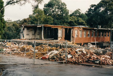
Photograph, Demolition of Eltham Shire Offices, 17 Aug 1996, 17/8/96
... Offices, Main Road, Eltham being demolished. 17 August, 1996... photographs of the Shire of Eltham Council Offices, Main Road, Eltham ...Three colour photographs of the Shire of Eltham Council Offices, Main Road, Eltham being demolished. 17 August, 1996. This followed Victorian Local Government re-amalgamations in 1994. This was a multi-story building which also included the Eltham Library.shire of eltham, demolition, buildings -
 Eltham District Historical Society Inc
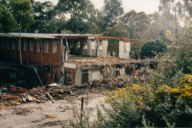
Photograph, Demolition of Eltham Shire Offices, 17 Aug 1996, 17/8/96
... Offices, Main Road, Eltham being demolished. 17 August, 1996... photographs of the Shire of Eltham Council Offices, Main Road, Eltham ...Three colour photographs of the Shire of Eltham Council Offices, Main Road, Eltham being demolished. 17 August, 1996. This followed Victorian Local Government re-amalgamations in 1994. This was a multi-story building which also included the Eltham Library.shire of eltham, demolition, buildings -
 Eltham District Historical Society Inc
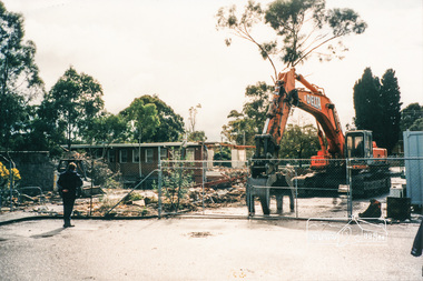
Photograph, Demolition of Eltham Shire Offices, 17 Aug 1996, 17/8/96
... Offices, Main Road, Eltham being demolished. 17 August, 1996... photographs of the Shire of Eltham Council Offices, Main Road, Eltham ...Three colour photographs of the Shire of Eltham Council Offices, Main Road, Eltham being demolished. 17 August, 1996. This followed Victorian Local Government re-amalgamations in 1994. This was a multi-story building which also included the Eltham Library.shire of eltham, demolition, buildings -
 Eltham District Historical Society Inc
Photograph, Plan 1; Shire of Eltham infrastructure plan for Baldwin Avenue, Lilicur Road and Price Avenue, Montmorency, c.1972, 1972c
... Shire of Eltham road construction and realignment works... melbourne Shire of Eltham road construction and realignment works ...Shire of Eltham road construction and realignment works on Baldwin Avenue, Lilicur Road and Price Avenue, Montmorency, c.1972 Note that proposed Hawthorn Grove was not developed35mm colour positive transparency blue Agfacolour Service plastic mountbaldwin avenue, hawthorn grove, infrastructure, lilicur road, price avenue, road construction, sherbourne road -
 Eltham District Historical Society Inc
Photograph, Plan 2; Shire of Eltham infrastructure plan for Baldwin Avenue, Lilicur Road and Price Avenue, Montmorency, c.1972, 1972c
... Shire of Eltham road construction and realignment works... melbourne Shire of Eltham road construction and realignment works ...Shire of Eltham road construction and realignment works on Baldwin Avenue, Lilicur Road and Price Avenue, Montmorency, c.1972 Note that proposed Hawthorn Grove was not developed35mm colour positive transparency blue Agfacolour Service plastic mountbaldwin avenue, hawthorn grove, infrastructure, lilicur road, price avenue, road construction, sherbourne road -
 Greensborough Historical Society
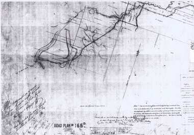
Document - Road Plan, Road acquisition, St Helena Road, 1859, 1889
... Creek (NOT Diamond Creek Road), also known as Eltham Road... as Eltham Road and now known as St Helena Road. Shows the land ...Road plan showing land acquisition for the road to Diamond Creek (NOT Diamond Creek Road), also known as Eltham Road and now known as St Helena Road.Shows the land through which St Helena Road runs, with original owners marked on plan.1 page. Copy of road planroad plans, st helena road greensborough, diamond creek -
 Eltham District Historical Society Inc
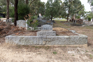
Photograph, Peter Pidgeon, Grave of William Hill and Agnes Somerville Irvine and family, Eltham Cemetery, Victoria, 5 April 2021
... in Laughing Waters Road at Eltham, where he built the house ‘Killeavey...Mount Pleasant Road, Eltham, Victoria, Australia... in Laughing Waters Road at Eltham, where he built the house ‘Killeavey ...William Hill Irvine was born 6 July, 1858 in Newry, County Down, Ireland. He arrived in Melbourne December 1879 and taught at Geelong College. He was admitted to the Supreme Court in 1884 having qualified from Melbourne University and practiced in Melbourne. In 1891 he married Agnes Somerville Wanliss and they had one son, William Mitchell (1901 Armadale) and two daughters, Beatrice Wanliss (1899 Armadale) and Agnes Somerville Wanliss (1903 Armadale). Sir William Irvine sat in the Victorian Parliament (as Liberal Member for Lowan) from 1894 to 1906 and was Premier of Victoria from 1902 to 1904. He then switched to Federal politics and sat in the Commonwealth Parliament (as Liberal Member for Flinders) from 1906 to 1918. He was considered a potential Prime Minister, but his abrupt manner and hard-line conservatism (particularly his attitude to a railway strike) made him unacceptable even to many Liberals: he was known in Parliament as "Iceberg Irvine". He lived at Richmond, but in 1908 purchased land in Laughing Waters Road at Eltham, where he built the house ‘Killeavey’, initially as a weekend retreat. The site, a peninsula surrounded on three sides by the Yarra River, is of geological importance and has considerable cultural significance to the Wurundjeri. In 1912 Sir William moved to Killeavey and in 1913 purchased more land, extending his property to Reynolds Road. In 1923 he shifted to Toorak, donating Killeavey to his daughter Beatrice as a wedding gift. Sir William was a founding member of the RACV and was Acting Governor of Victoria from 1931 to 1934. He was also a notable public figure involved in several local events including the: 1919 Unveiling of Eltham War Obelisk 1921 Eltham Primary School Extensions 1921 Eltham Primary School Roll of Honour of prior students 1928 Opening of Eltham Higher Elementary School 1926 Unveiling the Shire of Eltham War Memorial in Memorial Park at Kangaroo Ground He died in 1943 and is buried in Eltham Cemetery with his wife Agnes along with son William Mitchell Irvine and his wife, Dora Haswell Sacred to the memory of William Hill Irvine G.C.M.G. Lieutenant Governor And Chief Justice of Victoria Born 6th July 1858 At Newry, Northern Ireland Died 20th August 1943 Also his wife Agnes Somerville Born at Ballarat 16th Nov 1867 Died at Eltham 16th Aug 1954 W. M. W. Irvine 1901-1975 And Dora Haswell Wife of W. M. W. Irvine 1900-1979Born Digitaleltham cemetery, gravestones, agnes sommerville irvine (nee wanliss), dora haswell irvine, william hill irvine, william mitchell irvine -
 Eltham District Historical Society Inc
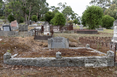
Photograph, Peter Pidgeon, Grave of George and Mary Knapman. Eltham Cemetery, Victoria, 5 April 2021
... was elected president of the Eltham Progressive League, calling...Mount Pleasant Road, Eltham, Victoria, Australia... was elected president of the Eltham Progressive League, calling ...George Knapman was born c.1851 in Ashburton, Devon, England, the son of George Knapman and Elizabeth Grant nee Wyatt. George, his mother and three sisters arrived in the Port of Melbourne, 28 Jul 1857 aboard the ship, Mindoro from Plymouth, his father having preceded them some eighteen months earlier. George married Mary Jane Williams in 1877 and they settled in Eltham where they had five children; Percival George (1878), Florence Maud (1880), Laura Blanche (1882), Alfred Edgar (1886) and Gladys Victoria (1897). In 1879 George was elected a vestryman for St Margaret’s Church, a position he would be re-elected to for many years. Both he and Mary were active members of the church and social activities. In 1884 George was also engaged in collecting funds for the renovation of the St Helena church George was also a member of the Eltham Cricket Club. In May 1884 following completion of the cricket season, several players banded together to form a group holding fortnightly meetings for the purpose of giving readings, recitations, etc to relieve the dullness of the long winter evenings. Charles Wingrove was elected President, Rev. J.B. Gason Treasurer and George along with Messrs Evans, Bourke, D. McColl, C. Jarrold, George Hill and William Brown, members of the Committee. In 1885, George advertised two horses had strayed from his premises (reward £2) and in 1891 he had a cultivator for sale (price £7/10/-). In 1902 he was treasurer of the Eltham Rifle Club. His children attended Eltham Primary School. In 1904 he was a member of the school's Board of Advice and addressed children at an Arbor Day planting activity. In 1907 he was elected president of the Eltham Progressive League, calling for public toilets to be erected at a local picnic spot. George along with William John Taylor and Isaac Hill was also appointed a Trustee of the Eltham Rechabite Hall in Henry Street on behalf of the Hope of Eltham Tent No. 195 Victoria District Independent Order of Rechabites from December 1901 until its sale to the community in December 1921 for use as a public hall. George ‘Snowy’ Knapman was a blacksmith by trade. He owned and operated a shoeing forge and wheelwright workshop, known as Snowy Knapman’s Forge, in Main Road Eltham, next door to the Eltham Court House. The location was well chosen. Mail coaches from Melbourne passed through Eltham enroute to Christmas Hills and Yarra Glen, with another heading to Kingstown (now Panton Hill). It was common practice for horses to be changed at Eltham. Two photos taken June 4, 1907, captioned ‘Election Day Eltham’, show a large crowd of men assembled in Main Road outside Knapman's premises. They are waiting to vote at the Court House. There are no women in the crowd; they were not empowered to vote. George's brothers William and John were also blacksmiths at Heidelberg, continuing the business established by their father George, who had died in 1900. After William died in 1909, George moved to Heidelberg to take over from him. George died at his residence, ‘Devon’, Yarra Street, Heidelberg on March 16, 1923, and is buried in Eltham Cemetery with his wife Mary who died July 16, 1935, at Kew. Their former house at Eltham was located near where the WW1 Monument was erected in 1919, after they had moved to Heidelberg, at the corner of Bridge Street and Main Road and occupied by Mr. R. Trevena at the time of Mary’s death. Mary was sister to E.J. Williams, W. Williams and Mrs Fawkner, all residents of Eltham. In Loving Memory of George Knapman Died 15th March 1923 Also his wife Mary Jane Died 16th July 1935 Sadly Missed Born Digitaleltham cemetery, gravestones, george knapman, mary jane knapman (nee williams) -
 Eltham District Historical Society Inc
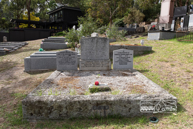
Photograph, Peter Pidgeon, Graves of George and Janet Bird and family, Eltham Cemetery, Victoria, 5 April 2021
... (also selling confectionery) in Main Road opposite Eltham...Mount Pleasant Road, Eltham, Victoria, Australia... (also selling confectionery) in Main Road opposite Eltham ...George Bird was born in England in 1845 and arrived in Australia in 1856 as a child of assisted migrants. Soon afterwards he came out to Eltham to live with his uncle George Stebbings, working for him as bricklayer's assistant in building, amongst others, Shillinglaw Cottage and the Anglican and Methodist Churches in Eltham. He later purchased 72 acres at the eastern end of Pitt Street (bounded by Eucalyptus Road, Mount Pleasant Road and present-day Rockliffe Street) and established the property ‘View Hill’, which was worked as a mixed farm and orchard (including berries). In 1878 he married Janet Kilpatrick, who had emigrated from Scotland. They had ten children, three of whom died in infancy. The wedding in 1904 of their eldest surviving daughter Sarah (‘Sis’) to Edward Pepper appears to have been quite a society event. George was a staunch Methodist and was a Church Steward and a Sunday School Superintendent in about 1890. Janet died in 1915 and George died in 1920 (though his gravestone says 1921). George's will stated that his property was to be divided between all his children in equal shares. This necessitated subdivision of the View Hill property, which took place progressively between 1922 and 1926. One son, George Hugh Bird, operated a drapery store in Main Road (near Bridge Street) in around 1915. Later, in the 1920s, he ran a greengrocer's shop (also selling confectionery) in Main Road opposite Eltham Station. It was the first shop in Eltham to have plate glass windows. At the same time, his brother Reg had a grocery store on the station side of Main Road. George and Janet are buried together in a family plot in Eltham Cemetery. Several descendants are also buried in the cemetery. In Loving Memory Of George Bird Died 5 December 1921 aged 76 years And his beloved wife Janet Bird Died 5 Sept 1915 aged 57 years Also their children William James Bird Died 25 Feb 1888 aged 8 years Mary Jane Bird Died 8 Oct 1891 aged 7 years Pte Edwin John Bird Killed in action in the Great War 11 Aug 1918 aged 30 years Buried in France And on the base stone George Hugh Bird Died 26 Feb. 1965. Aged 79 years Arthur Andrew Bird Died 25 Mar. 1970 Aged 75 years To the left In Loving Memory of Dr. J. R. (Roger) Bird 1927 2001 Son of Arthur & Helen (nee Lyon) Bird Husband of Betty Father of Janet & Alison Grandpa of Evan & Helen Scientist & Gentleman To the right In Loving Memory of Harold Edwin Bird OAM 1922 - 2015 Son of Arthur & Helen (nee Lyon) Bird Husband of Yvonne Father of Estell & Russell In our hearts Forever moreBorn Digitaleltham cemetery, gravestones, arthur andrew bird, arthur bird, edwin john bird, george bird, george hugh bird, harold edwin bird, helen bird (nee lyon), j. r. (roger) bird, janet bird (nee kilpatrick), william james bird, yvonne bird -
 Eltham District Historical Society Inc
Photograph, Jim Connor, Former C.B.A. Bank, 14 Jan 2017
... 804 Main Road, Eltham. It is a significant building... and is located near 804 Main Road, Eltham. It is a significant building ...The Former Commonwealth Bank of Australia branch forms part of the Eltham Gateway and the Little Eltham precinct and is located near 804 Main Road, Eltham. It is a significant building and registered on the Victorian Heritage Register. The bank was built in 1878. It is a one-room, bichromatic brick building. Imagine your bank only being open for one morning a week! These were the hours of the Commercial Bank’s Eltham branch early in the 20th century and customers were quite content. The bank stored gold from the Eltham/Research mining areas. It is famous for its bullet holes. These were the result of a hold up in 1949, in which a nervous youth opened an account in the name of John Henderson, then walked to the door and spun around pulling out a pistol he fired into the cedar bench but fled empty handed and was apprehended later, receiving a two year sentence. The Bank was purchased by the Methodist Church in 1954. (The Eltham church is right adjacent). Recent uses have included a meeting room, Sunday School and Opportunity Shop. It is currently used as a storage for the Combined churches opportunity shop which is located in the United church extension beside this location. Tomorrow's history documented todayeltham, jim connor collection, main road, eltham gateway, cba bank, opportunity shop -
 Eltham District Historical Society Inc
Photograph, Street near Eltham
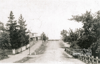
... Main Road Eltham looking south from opposite John Street... melbourne main road pitt street eltham hotels Main Road Eltham ...Main Road Eltham looking south from opposite John Street towards Pitt Street showing Eltham Hotelmain road, pitt street, eltham, hotels -
 Eltham District Historical Society Inc
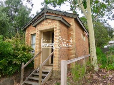
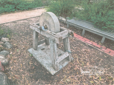
Photograph, Grindstone
... situated behind the EDHS Local History Centre at 728 Main Road... Road, Eltham Grindstone Photograph ...Colour paper print of a photograph of the grindstone situated behind the EDHS Local History Centre at 728 Main Road, Elthameltham, edhs, grindstone -
 Eltham District Historical Society Inc
Photograph - Aerial Photograph, Main Road, intersection Grand Boulevard and Panorama Avenue, Lower Plenty / Montmorency, 2 Jul. 1951
... study of Main Road widening shire of eltham archives Aerial ...Not originally catalogued in Shire of Eltham Archives but from the same series of photos taken for Country Road Board study of Main Road wideningshire of eltham archives, aerial photo, country roads board, eltham, main road, road widening, 1951-07, airlie road, ambulance station, beleura grove, grand boulevard, looker road, lower plenty, montmorency, panorama avenue -
 Eltham District Historical Society Inc
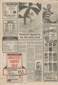
Program, Diamond Valley News, Festival tipped to be the best ever, Diamond Valley News, Tuesday, October 23, p2, 1984
... Club Eltham Main Road Phoenix Club Research primary school Ash ...Events and information concerning the 10th Eltham Community Festival held 16-18 November, 1984 [Photo of Keir Baker of Research Primary School] On the reverse (page 1) Fireman officially honoured, Diamond Valley News, Tuesday, October 23, 1984, p1 Opening of the Panton Hill Firemen's Memorial Park by the Member for Evelyn, Mr Max McDonald on Sunday 21 October, 1984 in memory of the five firemen who lost their lives on Ash Wednesday (1983) fighting the fire at Upper Beaconsfield - Maurie Atkinson, Stuart Duff, Neville Jeffrey, Bill Marsden and Peter Singleton [Photo of the memorial and Mr Max McDonald]]Newsprint1984, apex club, eltham community festival, eltham festival, eltham jazz festival, eltham living and learning centre, eltham rotary, eltham service club, eltham town park, grand parade, jaycees, keir baker, lions club eltham, main road, phoenix club, research primary school, ash wednesday, bill marsden, cal martin, diamond valley big band, evelyn, maurie atkinson, max mcdonald mp, neville jeffrey, panton hill firemen's memorial park, peter singleton, stuart duff, victorian bushfires - 1983 -
 Eltham District Historical Society Inc
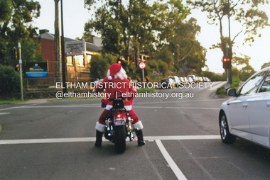
Photograph, Fay Bridge, Santa Claus is coming to Eltham, December 2011
... Christmas Dudley Street Eltham Main Road Santa Claus 1 image ...Main Road at Dudley Street and Santa Claus is coming to town. Unfortunately, after Santa had passed through, late on Christmas Day afternoon a strong storm also swept in from the south bringing torrential rain and large hail resulting in flash flooding and wide spread storm damage.fay bridge collection, 2011-12, christmas, dudley street, eltham, main road, santa claus -
 Eltham District Historical Society Inc
Photograph, Peter Pidgeon, Bridge Street, Eltham, 2 Aug. 2022
... melbourne Eltham Main Road Bridge Street Born Digital Bridge Street ...Born Digitaleltham, main road, bridge street