Showing 11033 items matching " land"
-
 Bendigo Historical Society Inc.
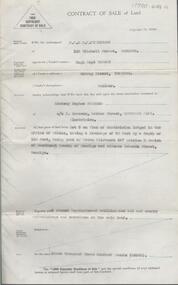
Document - H.A. & S.R. WILKINSON COLLECTION: CONTRACT OF SALE
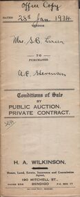
This business was owned by father and son, Henry Archibald Wilkinson and Samuel Ronald "Ron" Wilkinson. Henry (1882-1954) was born in Shepparton and died in Bendigo. He was married to Grace Hovendon in 1908. Samuel Ronald "Ron" (1914-1995), Henry's son, was married to Florence Jean McKerlie in 1937.Conditions of sale by private contract dated 28th January, 1934 between Mrs S.B. Larsen (seller) and A.E. Stevenson for land situate No.43 Breen Street, Bendigo being the land described in residence area certificate No. 32484 in the books of the mining registrar at Bendigo, together with 4-roomed weatherboard dwelling and all sundry. Also one ''Liverpool'' gas stove as inspected. Price 400 pounds. Attached a letter dated 23rd March, 1934 from the Bendigo Mutual Permanent Land and Building Society addressed to H.A. Wilkinson re: account Mrs. S. Larsen, acknowledging receipt of letter dated 22nd advising on behalf of Mrs. Larsen of sale of property at 43 Breen Street and of receipt of contract.organization, business, h.a. & s.r wilkinson real estate -
 Bendigo Historical Society Inc.
Document - H.A. & S.R. WILKINSON COLLECTION: CONTRACT OF SALE
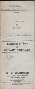
Conditions of sale by private contract dated 27th March, 1941 between J. Whitley (seller) and Mrs. L.A. Schleiger (buyer) for land situate 243 Queen Street, Bendigo being land described in right to occupy residence area right No. 7313, together with 4-roomed weatherboard dwelling and all sundry. Price 250 pounds. Office copy. Attached copy of insurance cover issued by the United Insurance Company Ltd for above said property.organization, business, h.a. & s.r wilkinson real estate -
 Bendigo Historical Society Inc.
Document - H.A. & S.R. WILKINSON COLLECTION: CONTRACT OF SALE
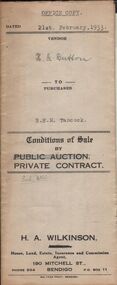
Conditions of sale by private contract dated 21st February, 1933 between H.G. Button (seller) and B.E. M. Tancock for land situate 31 Creel Street, Bendigo being part of Crown allotment 31 section 127C described in certificate of title volume 2313 folio 462535, together with 5-roomed weatherboard and brick dwelling, at present occupied by Mr. Malkin as tenant, and all sundry outbuildings on the said land. Price 160 pounds.organization, business, h.a. & s.r wilkinson real estate -
 Bendigo Historical Society Inc.
Document - H.A. & S.R. WILKINSON COLLECTION: CONDITION OF SALE
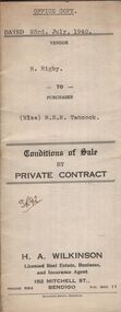
Conditions of sale by private contract dated 23rd July, 1940 between R. Rigby (seller) and Miss B.E.M. Tancock (buyer) for land situate corner Violet and Queen Streets, Bendigo, having a frontage to Queen Street of approx. 71 links by a depth of approx. 137 links to Violet Street, being land described in right to occupy residence area no. 4868, together with 5-roomed weatherboard dwelling and all sundry. Price 155 pounds.organization, business, h.a. & s.r wilkinson real estate -
 Bendigo Historical Society Inc.
Document - H.A. & S.R. WILKINSON COLLECTION: CONTRACT OF SALE
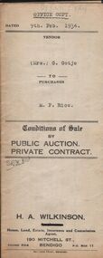
Conditions of sale by private contract dated 9th February, 1934 between Mrs. G. Gotje (seller) and M.P. Rice (buyer) for land situate corner McIvor road and Charleston Street being the land described in certificate of title volume 719 folio 143710, Crown grant volume 1483 folio 296595 and Crown grant volume 4148 folio 829492, together with 6-roomed stone and brick dwelling and all sundry. Price 725 poundsorganization, business, h.a. & s.r wilkinson real estate -
 Bendigo Historical Society Inc.
Document - H.A. & S.R. WILKINSON COLLECTION: CONDITION OF SALE
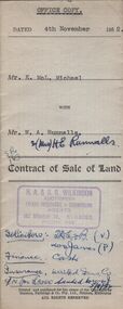
Contract of sale of land issued by H.A. Wilkinson and dated 4th November 1952 between Mr. K. McL. Michael (seller) and Mr. W. A. Runnalls for land being allotment 521 section M, Borough of Eaglehawk, Parish of Sandhurst County of Bendigo described in Crown grant volume 6071 folio 124 situate No. 23 Nelson Street California Gully, together with 5-roomed brick dwelling and all sundry. Price 1,950 pounds.organization, business, h.a. & s.r wilkinson real estate -
 Bendigo Historical Society Inc.
Document - H.A. & S.R. WILKINSON COLLECTION: CONDITION OF SALE
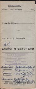
Contract of sale of land issued by H.A. & S.R. Wilkinson dated 7th October 1953 between Mrs. A. Milne (seller) and Mr. W.G.A. Redmond (buyer) for land situate in Pitt Street Bendigo being the southern portion of allotment 7 section 60B City of Bendigo Parish of Sandhurst described in right to occupy residence area right No. 4835, together with 5-roomed weatherboard and rough cast dwelling and all sundry. Price 2,200 pounds.organization, business, h.a. & s.r wilkinson real estate -
 Bendigo Historical Society Inc.
Document - H. A. & S. R. WILKINSON COLLECTION: CONTRACT OF SALE
Contract of sale of land dated 30th July, 1954 between Miss A. M. Gibson (vendor) and Miss M. J. Stritch (purchaser). Property: Allotment 13 section 7C Parish of Sandhurst, City of Bendigo, land described in conveyance no. 253 book 326 having a frontage of 66 feet to McLaren Street by a depth of 165 feet, together with all buildings erected thereon and known as No. 12 McLaren street, Bendigo. Price: 1,650 pounds.organization, business, h.a. & s.r wilkinson real estate -
 Bendigo Historical Society Inc.
Document - H. A. & S. R. WILKINSON COLLECTION: CONTRACT OF SALE
Contract of sale of land dated 17th August, 1955 between Mr. H. B. Morgan (vendor) and Mr. L. H. Parsons (purchaser). Property: land being lot 3 on plan of subdivision lodged in the office of titles, having a frontage of 50 feet by a depth of 150 feet, being part of Crown allotment 547section H and situate in Osborne Street, Bendigo, together with 5 roomed weatherboard dwelling and all sundry. Price: 3,300 pounds.organization, business, h.a. & s.r wilkinson real estate -
 Bendigo Historical Society Inc.
Legal record - Register of Special Land Sales Castlemaine, 28/06/2007
Light brown suede leather cover with ornate embossed edging; and label on spines stating "3 and Register of Special Land Sales". Land sales between 7/03/1862 to 20/04/1869, Castlemaine District on spine. Fine black handwritten entries. First page notes Report of a Sale on the 7th March 1862, in terms of Gazette notice of 7th July 1862. Sale conducted by Public Auction by Thomas Couchman Esq. Acting D.S.land sales, castlemaine, 1860s -
 Bendigo Historical Society Inc.
Legal record - Land Register
Land register for duration 1924 to 1951 (!!). Register contains plans of Land sales for a broad area of Central Victorian Parish / Counties. Register has a stiff blue card cover originally bound with light brown leather spine and corners, presently in a dire condition with cover damaged and loose; plans also folded and damaged. Plans inserted as drawn plans within the register, later plans are included on tracing, paper and linen - in various degrees of condition / damage.land register, central victoria -
 Kew Historical Society Inc
Photograph - Yarra River, Kew, 1925
Henry Beater Christian (1886-1962) , was a descendant of one of the earliest settler families in Kew. Employed at the Kew Asylum as a 'public servant', he was a skilled amateur photographer, photographing numerous scenes in Kew and on his travels around Victoria. The majority of his photographs date from 1916 to 1929. His finest photographs are housed in two photograph albums. Digital copy of a photograph from page 3 of the 47-page photograph album containing 261 gelatinous silver images, loaned by Diane Washfold with permission given to digitise and hold a copy in our collection. A photograph of a stretch of the Yarra River at Kew. From the 1840s, at the Crown Land Sales, lots adjacent to the river were sold and developed as dairy farms, hence the presence of cattle until the land was subdivided or created into golf courses during the twentieth century. "Yarra Rvr / Kew / 1925"henry beater christian (1886-1962), landscape photography, kew (vic.) — yarra river, christian-washfold collection, photograph albums, dairying -- kew (vic.) -
 Bendigo Historical Society Inc.
Administrative record - LANDS OFFICE: LAND BOARD SCHEDULE 1936 - 1949, 1936 - 1949
Ledger. Hard cover journal, orange-tan cover with leather spine and corners. Contains unused index in front of book. 740 pages with details of local land board dealings, including 'show cause'. On each page: schedule of applications and other matters considered by local land board at (name of area inserted). Some areas listed: Boort, Bendigo, Sea Lake, Robinvale, Swan Hill, Kerang, Kyabram, Castlemaine, Echuca, Daylesford, Manangatang.Lands Officeplace, land board schedules, bendigo, sandhurst, land sales -
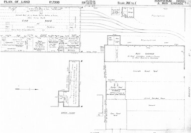 Melbourne Tram Museum
Drawing, Melbourne & Metropolitan Tramways Board (MMTB), "Footscray Depot and bus garage", c1937
Set of three photocopied plans or drawings on A3 sheet of "Footscray Depot and bus garage" c 1937 .1 - P7993 - Plan of land showing car shed, bus garage and offices dated 1-4-1937 - shows substation location. .2 - P? - Plan of land showing buildings and surrounding properties - dated 1-4-1937 .3 - P79821 - ditto but a wider area - dated 1-4-1937 - shows substation location.trams, tramways, drawings, depots, property, footscray depot, substation -
 Bendigo Historical Society Inc.
Document - H.A. & S.R. WILKINSON COLLECTION: CONTRACT OF SALE
Conditions of sale by private contract dated 20th May, 1938 between G. Earl Snr. (seller) and Mrs. M.A. Speechley (buyer) for land situate No.144 Victoria Street, Ironbark, being the land described in right to occupy residence area No. 4785, together with 4-roomed weatherboard dwelling, brick and concrete kitchen and all sundry. Also copper and stand, electric light fittings, wire doors and window screens. Price 210 pounds.organization, business, h.a. & s.r wilkinson real estate -
 Bendigo Historical Society Inc.
Document - H.A. & S.R. WILKINSON COLLECTION: CONTRACT OF SALE
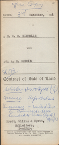
This business was owned by father and son, Henry Archibald Wilkinson and Samuel Ronald "Ron" Wilkinson. Henry (1882-1954) was born in Shepparton and died in Bendigo. He was married to Grace Hovendon in 1908. Samuel Ronald "Ron" (1914-1995), Henry's son, was married to Florence Jean McKerlie in 1937.Contract of sale of land dated 3rd December, 1953 between Mr. W.B. Nicholls (seller) and Mr. A.R. Reddie (buyer) for that piece of land that lies above the depth of 50 feet below the surface of lot 12 on plan of subdivision lodged at the office of titles in red ink No. 5394259 dated 19/1/1953 and being part of allotment 12 section 10 township Kangaroo Flat, together with all improvements thereon. Price 2,850 pounds.organization, business, h.a. & s.r wilkinson real estate -
 Ringwood and District Historical Society
Newspaper, Scrapbook Clipping, Library Collection, Ringwood, Victoria, `
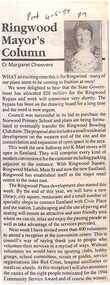
``Newspaper clipping from "The Post" 4 -5 - 94 P7 Ringwood Mayor's Column by Cr Margaret CheeversThe Mayor was happy about the allocation of $20 million for the Ringwood Bypass. Council was successful in is bid to purchase Norwood Primary School land, and various other achievements, including sports.` -
 Phillip Island and District Historical Society Inc.
Booklet, Phillip Island Holidays Development Pty Ltd, Ideal Summerland on the Nobbies, Phillip Island, Late 1920s
Subdivision of Summerland commenced in the 1920s with 12 large allotments created, along with features such as a roundabout and cypress trees. Between 1927 and 1931, 227 new blocks were created, and from 1929 to 1940 there was a nine-hole golf course on what is now the Penguin Parade car park.Historical Large 8 page glossy booklet advertising Summerland Estate, describing attractions of the area ,maps, houses , golf course. Basically black and white with some orange print and a coloured map.Ideal Summerland on the Nobbies Phillip Island. "The land of somewhere we long to go". Published by Phillip Island Holidays Development Pty Ltd. 6o Market Street, Melbourne.housing, tourism phillip island, summerland estate -
 Kew Historical Society Inc
Plan - Subdivision Plan, Bella Vista Estate, 1929
Pru Sanderson, in her groundbreaking ‘City of Kew Urban Conservation Study : Volume 2 - Development History’ (1988), summarised the periods of urban development and subdivisions of land in Kew. The periods that she identified included 1845-1880, 1880-1893, 1893-1921, 1921-1933, 1933-1943, and Post-War Development. These periods were selected as they represented periods of rapid growth or decline in urban development. An obvious starting point for Sanderson’s groupings involved population growth and the associated economic cycles. These cycles also highlighted urban expansion onto land that was predominantly rural, although in other cases it represented the decline and breakup of large estates. A number of the plans in the Kew Historical Society’s collection can also be found in other collections, such as those of the State Library of Victoria and the Boroondara Library Service. A number are however unique to the collection.The Kew Historical Society collection includes almost 100 subdivision plans pertaining to suburbs of the City of Melbourne. Most of these are of Kew, Kew East or Studley Park, although a smaller number are plans of Camberwell, Deepdene, Balwyn and Hawthorn. It is believed that the majority of the plans were gifted to the Society by persons connected with the real estate firm - J. R. Mathers and McMillan, 136 Cotham Road, Kew. The Plans in the collection are rarely in pristine form, being working plans on which the agent would write notes and record lots sold and the prices of these. The subdivision plans are historically significant examples of the growth of urban Melbourne from the beginning of the 20th Century up until the 1980s. A number of the plans are double-sided and often include a photograph on the reverse. A number of the latter are by noted photographers such as J.E. Barnes.Bella Vista (later ‘Malinda’) was a large Federation house designed by the architect Robert Haddon for Abel Hoadley. The house was built in 1902 and occupied the eastern corner of Thomas Street and Cotham Road. It was a single-storey, red brick house, set back from the road, featuring a central tower topped by a pagoda-like red terra cotta roof, on top of which was perched a very large terra cotta dragon. The Bella Vista subdivision of 1929 included Hoadley’s house as well as nine allotments facing Cotham Road and Alfred and Thomas Streets. In 1941, the land on which Hoadley’s house stood was to be further subdivided. Bella Vista is believed to have lasted until it was demolished in the 1980s.subdivision plans - kew, bella vista estate -
 Bendigo Military Museum
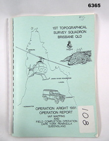
Administrative record - Royal Australian Survey Corps Report on Operation Aright 91 conducted by 1 Field Survey Squadron 1991, 1 Fd Svy Sqn, 7 Oct 1991
Royal Australian Survey Corps Operation Aright 91 (Field Completion) was a Field Verification and Vital Assets Protection (VAP) Mapping Operation conducted in Far North Queensland during the period 18 Jun - 29 Jul 1991 by 1 Fd Svy Sqn. The Operation covered the 1:250,000 Map area of SD54-16 Hann River and SE54-7 Normanton.Pale Blue cover with motifs of North Queensland, crocodile, RASvy Corps Badge, Army Helicopter and Land rover. Contains an A4 paper report of typed pages and diagrams secured by a plastic binder.Cover Hand annotated "ASS 108" (Air Survey Sqn, copy 108)royal australian survey corps, rasvy, fortuna, army survey regiment, army svy regt, asr -
 Bendigo Military Museum
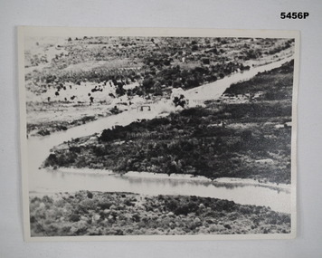
Photograph - PHOTOGRAPH, TAMARAN BRIDGE, British Air Force, C1943-1945
Refer Cat no. 5445.2Photo shows flat, uninhibited land. A river (low tide) snakes through the photo. In the centre is a trestle bridge crossing the river. A bomb ( water and smoke) blast is rising from the side of bridge Photograph rear in ink. “Tamaram bridge" being bombed. Bridge built by POWS. The span was never rebuilt. Trains stopping both sides and goods carried along foot of bridge, on a narrow bridge by POWs.ww2, pow, tamaran bridge, burma railway -
 Glenelg Shire Council Cultural Collection
Photograph - Photograph - aerial view of Portland, c. 1954
Black and white aerial photograph of coastline around Portland. Black border, scale all sides, 5 rows of 3 't' at regular intervals. Mostly ocean, section of land jutting out into it.Front: '607 - 41 ' - handwritten, white, border 'RUN 8' 'PORTLAND', printed, white, border -
Glenelg Shire Council Cultural Collection
Photograph - Photograph - aerial view of Portland, c. 1954
Black and white aerial photograph of coastline around Portland. Black border, scale all sides, 5 rows of 3 't' at regular intervals. Only 10% land visible, top rightFront: '784 - 155- handwritten, white, border 'RUN 7 A PORTLAND', printed, white, borderaerial photography, central portland, portland harbour, south west coastline -
Glenelg Shire Council Cultural Collection
Photograph - Photograph - aerial view of Portland, c. 1954
Black and white aerial photograph of coastline around Portland. Black border, scale all sides, 5 rows of 3 't' at regular intervals. Same area as 8465, 8466, 80% land.Front: '607 - 63 ' - handwritten, white, border 'RUN 7 PORTLAND', printed, white, borderaerial photography, central portland, portland harbour, south west coastline -
Glenelg Shire Council Cultural Collection
Photograph - Photograph - aerial view of Portland, c. 1954
Black and white aerial photograph of coastline around Portland. Black border, scale all sides, 5 rows of 3 't' at regular intervals. Small area of ocean, rest land with lakes.Front: '820 -9' - handwritten, white, border 'RUN 5' 'PORTLAND', printed, white, lower borderaerial photography, central portland, portland harbour, coastline -
Glenelg Shire Council Cultural Collection
Photograph - Photograph - aerial view of Portland, c. 1954
Black and white aerial photograph of coastline around Portland. Black border, scale all sides, 5 rows of 3 't' at regular intervals. Start of headland, 80/20 ocean to landFront: '784 - 149' - handwritten, white, border 'RUN 7 A PORTLAND', printed, white, borderaerial photography, central portland, portland harbour, south west coastline -
 Warrnambool and District Historical Society Inc.
Book, Book Certificate of Titles A-Z Index, C 1890
This book contains certificates of title and Crown grants which record local changes of ownership.many are in the township of Warrnambool while others relate to areas such as Nullawarre, Purnim and Framlingham.These documents come under the Transfer of lands act of 1890.This book has many local names and properties and is an historic link for the district.Brown heavy card cover with red fabric binding. It has an alphabetical index at the front followed by 200 pages of certificates of title.Descriptions of the land is written at the top of the pages with drawn and coloured diagrams below. The dates range from C 1878 to to C 1966. Some are certificate of title and others are Crown Grant. warrnambool, certificate of titles warrnambool 1900 -
 Ringwood and District Historical Society
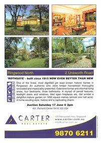
Memorabilia - Property History, Rothsaye, 2 Unsworth Road Ringwood North, Victoria
"Rothsaye" was built in 1917 by J.B. McAlpin who was a councillor in Lillydale and Ringwood and was Mayor in 1928-29.Multi pocket burgundy coloured spiral binder containing 34 pages of the property history, subdivisions, land titles and photographs of the house, compiled by Richard Carter pre-auction 17 June 2006 -
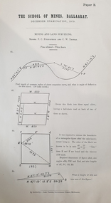 Federation University Historical Collection
Document, The School of Mines Examinations, 1874-1882, 06/1874
A number of printed, foolscap examinations for the Ballarat School of Mines, including: Mining and Land Surveying - Levelling (Examiners P.C. Fitzpatrick and C.W. Thomas, 1879 Metallurgy (Examiner J. Cosmo Newbery), 1882ballarat school of mines, examination, engineers, engineering, p. matthews, jonathan robinson -
Glenelg Shire Council Cultural Collection
Photograph - Photograph - Lee Breakwater, Portland, n.d
Port of Portland Authority Archivesport of portland archives, lee breakwater