Showing 6696 items
matching river
-
 Ballarat Heritage Services
Image - Black and White, Leeton Irrigation Settlement, c1950, c1950
A black and white image of a wide street in Leeton Irrigation Settlement.corowa, customs house, river, bridge -
 Ballarat Heritage Services
Photograph
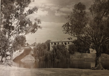
river, bridge, double storey, willow -
 Ballarat Heritage Services
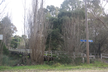
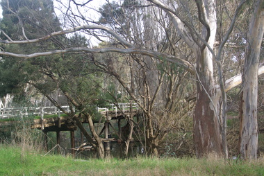
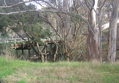
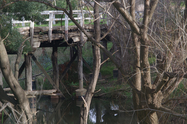
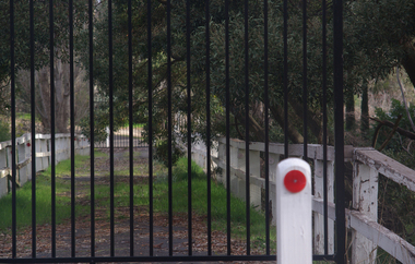
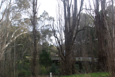
Photograph - Colour, Bridge From Vaughan to Tarilta, 2017, 16/07/2017
Colour photograph of the bridge between Vaughan and Tarilta. It has been closed to traffic.vaughan, tarilta, bridge, river -
 Ballarat Heritage Services
Photograph - Colour, Bridge From Vaughan to Tarilta, 2017, 16/07/2017
Colour photograph of the bridge between Vaughan and Tarilta. It has been closed to traffic.vaughan, tarilta, bridge, river -
 Ballarat Heritage Services
Photograph - Colour, Bridge From Vaughan to Tarilta, 2017, 16/07/2017
Colour photograph of the bridge between Vaughan and Tarilta. It has been closed to traffic.vaughan, tarilta, bridge, river -
 Ballarat Heritage Services
Photograph - Colour, Bridge From Vaughan to Tarilta, 2017, 16/07/2017
Colour photograph of the bridge between Vaughan and Tarilta. It has been closed to traffic.vaughan, tarilta, bridge, river -
 Ballarat Heritage Services
Photograph - Colour, Bridge From Vaughan to Tarilta, 2017, 16/07/2017
Colour photograph of the bridge between Vaughan and Tarilta. It has been closed to traffic.vaughan, tarilta, bridge, river -
 Ballarat Heritage Services
Photograph - Colour, Bridge From Vaughan to Tarilta, 2017, 16/07/2017
Colour photograph of the bridge between Vaughan and Tarilta. It has been closed to traffic.vaughan, tarilta, bridge, river -
 Ballarat Heritage Services
Photograph - Colour, Bridge From Vaughan to Tarilta, 2017, 16/07/2017
Colour photograph of the bridge between Vaughan and Tarilta. It has been closed to traffic.vaughan, tarilta, bridge, river -
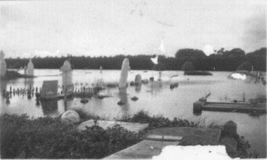 Port Fairy Historical Society Museum and Archives
Photograph
1946 was the year of the biggest flood experienced in Port Fairy. This photograph shows evidence of the inundation at the Port Fairy Cemetery situated at the West of the townBlack and white photograph of headstones surrounded by waterflood, river, 1946, headstone -
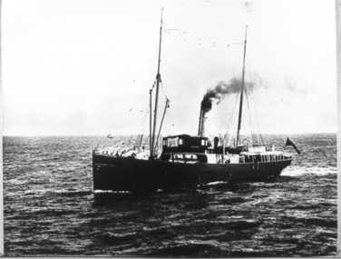 Port Fairy Historical Society Museum and Archives
Photograph, Lady Loch
Government steamer serving lighthouses along the coast and in Bass Straight Steamer, 146 nhp. Built 1886. Built In Melbourne. Tonnage 487g 337n. Built By Campbell, Sloss & M'Cnn Dimensions182.7 x 24.6 x 14.4 Demise Campbell, Sloss & McCann, Sth Melbourne. Lighthouse tender. Later: Victorian Government (Department of Public Works), reg. Melbourne. Later Moreton Tug & Lighter Co. 1962: Scuttled at Dunwich, Moreton Bay, Qld.Black and white photographship, boat, river, sea -
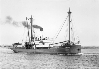 Port Fairy Historical Society Museum and Archives
Photograph, SS Coombar
Black and white photographship, boat, sea, river -
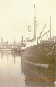
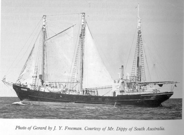 Port Fairy Historical Society Museum and Archives
Photograph, SS Gerard
Black & white photographship, boat, sea, river -
 Port Fairy Historical Society Museum and Archives
Photograph, Iron steamer SS Edina
Came to Australia from Glasgow in 1865 and ran from Portland to Melbourne, then to New Zealand when gold was discovered there. In 1880 ran on the Melbourne-Geelong passenger and freight service. A Crimean War ship she had many collisions and ‘incidents’ during her long life, and became known as a ‘collision specialist’.B&W photographship, boat, sea, river -
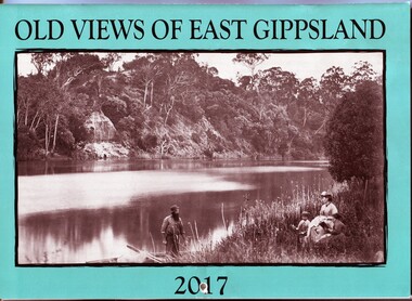 Orbost & District Historical Society
calendar, E-Gee Printers, Old Views of East Gippsland 2017, 2016
This is one of a series of calendars compiled annually by East Gippsland Historical Society.This is a useful pictorial reference tool.A 2017 stapled calendar, titled "Old Views of East Gippsland". On the turquoise coloured front is a black/white photograph of Eagle Point, Mitchell River C 1875 with a family group, possibly Alfred Howitt and children, on the bank of the Mitchell River opposite Eagle Point Bluff.. It contains early photographs of East Gippsland,. There is a hole for hanging. The title is at the top and the year at the bottom in black print. calendar-old-views-of-east-gippsland photographs-historic-east-gippsland -
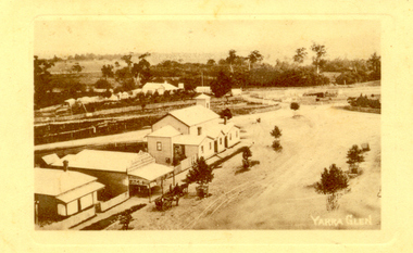 Yarra Glen & District Historical Society
Sepia postcards, Yarra Glen
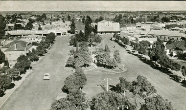
Sepia postcard with a view taken from the Grand Hotel tower looking down on Bell Street and the railway crossing at Yarra Glen very late 19th century. Young street trees on Bell Street. On east side of Bell Street are a dwelling, a general store, the Victoria Hall, a horse trough. Beyond the railway line is 'River View', the bridge over the river and the Yering flats.On back of postcard at the top "POST CARD". On the left hand side "THIS SPACE MAY BE USED FOR PRINTED OR WRITTEN MATTER”. On the right hand side "ONLY THE ADDRESS TO BE WRITTEN HERE”. In a box in the right hand corner "A HALF-PENNY STAMP TO BE PLACED HERE". Along the left hand margin "Ajax series. Printed in England". In blue biro is written "G. Keets Yarra Glen". Copy 2 has the following handwritten in black ink: "Yarra Glen. 28.8.11. Dear Maggie Hope you will like the Postcard. I also hope your head is better. On Saturday we took the kitten down to Dawborn's shop to catch some mice. When we got down there the kitten got away from us and we never got it till Monday morning. This is all the news this time. From your loving cousin, Walter.yarra glen, railway line, grand hotel, victoria hall, bell street, tree guards, railway crossing, river view, street trees, bell st, general store, horse trough -
 Bendigo Historical Society Inc.
Map - REDESDALE : COUNTY OF BENDIGO, 24-12-24
Map. Redesdale, County of Bendigo, County of Dalhousie, Kimbolton, Langwornor, Spring Plains, Glenhope, Emberton, Metcalfe, Hawkestone, County of Talbot, Campaspe River, Back Creek, River Coliban, Lyell. By authority H.J. Green, Government Printer, Melbourne. Photo-Lithographed at the Department of Lands and Survey, Melbourne by W.J. Butson, 24-12-24, Price 1/-. (number 120 in map cupboard 1)H.J. Green, Government Printer, Melbourne.map, bendigo, redesdale -
 Sunshine and District Historical Society Incorporated
Photographs (1928), 'QUARTER MILE' BRIDGE Construction, 1928
One man lost his life during the building of this bridge. The bridge was constructed by the Victorian Railways between 1927 to 1929 to carry a new double track goods line. This enabled trains from all parts of the state except Gippsland to have direct access to the Tottenham marshalling and sorting yards. These yards were constructed in the 1920's to relieve congestion in the Melbourne Yard near Spencer Street station. The congestion was being caused by the construction of suburban passenger platforms associated with the electrification of the suburban railway network. Initially the bridge was for goods trains but during the Second World War it was also used by troop trains. When the standard gauge line was built in 1962 all trains to Albury and Sydney have used this route, thus avoiding travelling through Essendon and Pascoe Vale on the suburban tracks. The standard gauge track across the bridge took the place of one of the broad gauge tracks so broad gauge trains crossing the bridge in either direction have to now use the same track. The bridge is 1,257 feet (383.13 metres) long and 180 feet (54.86 metres) above the water level. It is just 63 feet (19.2 metres) short of a quarter mile in length between abutments. There is a similar bridge on the same railway line crossing the Moonee Ponds Creek between Gowenbrae and Glenroy, however it is smaller at 1060 feet (323.08 metres) length and 115 feet (35.05) height.The bridge is now Victorian Heritage Registered under Number: H1197, and Heritage Overlay Numbers HO5, and HO107. On the Heritage Register it is named RAIL BRIDGE (ALBION VIADUCT). According to the Heritage Report the bridge is scientifically and architecturally important because of its large size, and because of the cost effective design features such as two girders per span (one for each track), the K bracing in the towers, and the broad flange beams as columns. When it was being built it was the largest trestle bridge in Australia, and until the Sydney Harbour bridge was constructed it was the highest railway bridge.Five B&W yellowing photos showing stages of construction of the Maribyrnong River Viaduct known as the Trestle Bridge but mainly known locally as the QUARTER MILE BRIDGE. It is a railway only bridge which runs over the Maribyrnong River between Sunshine North and Keilor East. A sixth image, which is not part of this set of photos, is included to show what the completed bridge looks like. -
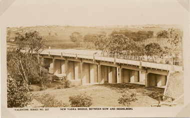 Kew Historical Society Inc
Postcard, Valentine Publishing Co Pty Ltd, New Yarra Bridge, Between Kew and Heidelberg, 1926-1930
Without bridges, Kew remained cut off from the City of Melbourne, only being accessible by Punt. Private and public bridges were constructed from the 1850s, beginning with the Hawthorn Bridge linking Bridge and Burwood Roads. A bridge across the Yarra at Burke Road was created as early as 1873. Since that first wooden bridge, a number of later bridges, typically on concrete pylons have been built, in 1926 and again during the 1970s.Angle view of the new Yarra bridge [ie. The Burke Road bridge] taken from the Kew side, showing the bridge’s structure. Trees line the river’s edge. In the distance can be seen a distant line of houses stretching to the horizon. The river appears to have an S-shaped bend beyond the bridge. The postcard, No. 227, was produced by the Valentine Publishing Co. Pty Ltd., of Queen Street, Melbourne.burke road bridge - kew (vic), bridges - kew (vic) -
 Kew Historical Society Inc
Photograph - Dight's Falls, 1924
Henry Beater Christian (1886-1962) , was a descendant of one of the earliest settler families in Kew. Employed at the Kew Asylum as a 'public servant', he was a skilled amateur photographer, photographing numerous scenes in Kew and on his travels around Victoria. The majority of his photographs date from 1916 to 1929. His finest photographs are housed in two photograph albums. Digital copy of a photograph from page 9 of the 47-page photograph album containing 261 gelatinous silver images, loaned by Diane Washfold with permission given to digitise and hold a copy in our collection. The point-of-view selected by the photographer, Henry Christian, is of Dight's Falls on the Yarra River from the Kew side. Dight's Falls separates the saline and fresh water sections of the river. "Studley Park / Kew"henry beater christian (1886-1962), landscape photography, kew (vic.) — yarra river, christian-washfold collection, photograph albums, yarra river -- studley park (vic.), dight's falls -
 Kew Historical Society Inc
Photograph - Yarra River below Dight's Falls, 1924
Henry Beater Christian (1886-1962) , was a descendant of one of the earliest settler families in Kew. Employed at the Kew Asylum as a 'public servant', he was a skilled amateur photographer, photographing numerous scenes in Kew and on his travels around Victoria. The majority of his photographs date from 1916 to 1929. His finest photographs are housed in two photograph albums. Digital copy of a photograph from page 9 of the 47-page photograph album containing 261 gelatinous silver images, loaned by Diane Washfold with permission given to digitise and hold a copy in our collection. The point-of-view selected by the photographer, Henry Christian, is below Dight's Falls on the Yarra River from the Kew side. Dight's Falls separates the saline and fresh water sections of the river. "Studley Park / Kew"henry beater christian (1886-1962), landscape photography, kew (vic.) — yarra river, christian-washfold collection, photograph albums, yarra river -- studley park (vic.), dight's falls -
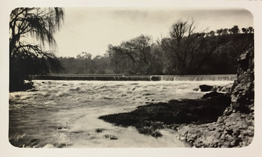
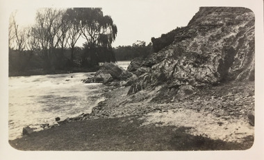
 Orbost & District Historical Society
Certificate
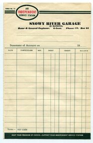
Frank Matthews was a well-respected garage owner and mechanic in Orbost for many years. Evidence of ownership and existence of the Snowy River Garage, Orbost Rectangular paper, printed in black ink, the word INDEPENDENT is printed in red inside an oval shape. An INDEPENDENT Service Station Snowy River Garage (F Matthews) Motor & General Engineer, Orbost Ph. 77 Box 93snowy river garage, orbost, frank matthews -
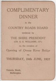 Rutherglen Historical Society
Menu and Toast List, Complimentary Dinner to the Country Roads Board, 1937 (exact)
Dinner was held at the Victoria Hotel, Rutherglen. The Shire President was Cr. S.G. Williams, J.P.Small card folder, with menu and toast list"Complimentary Dinner to the Country Roads Board tendered by the Shire President on the occasion of the opening of the Ovens River Bridge on 24th June, 1937"country roads board, ovens river bridge, opening celebration -
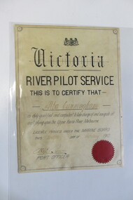 Seaworks Maritime Museum
Certificate, 12/02/1912
A4 sized certificate with a black border and red seal. "Victoria/ River Pilot Service/ This is to certify that/ Alba Cunnigham/ is duly qualified and competent to take charge and navigate all/ craft plying upon the Upper Yarra River Melbourne/ Licence issued under the Marine Board/ This twelfth day of February 1912/ Port Officer" written with pencil on the back "7.06" -
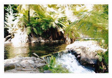 Marysville & District Historical Society
Photograph (item) - Colour photograph, Pre 2009
A colour photograph of the pool at the base of the Steavenson Falls in Marysville in Victoria. A colour photograph of the pool at the base of the Steavenson Falls in Marysville in Victoria. The Steavenson Falls is named after the Victorian Assistant Commissioner of Roads and Bridges, John Steavenson who arrived in Victoria in the early 1860s.steavenson falls, waterfalls, marysville, victoria, john steavenson -
Glenelg Shire Council Cultural Collection
Negative - Negative -Donovan's Landing Nelson, Victoria, c. 1936
Negative for a black and white photograph. Image shows Donovan's landing, Nelson Victoria. Group of 7 people standing on a small landing, river, boat sheds in background. -
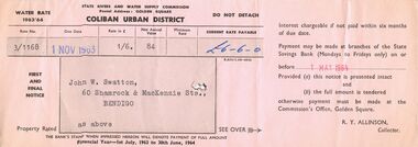 Bendigo Historical Society Inc.
Document - J W SWATTON COLLECTION: STATE RIVERS AND WATER COMMISSION ACCOUNT
Account issued by State Rivers And Water Supply Commision for water rates 1963/64 addressed to J. W. Swatton 60 Shamrock and MacKenzie Streets, Bendigo.essential services, water supply -
Port Melbourne Historical & Preservation Society
Plan - Possible maritime shed, Borough of Sandridge, 1870s
An identified building plan - presumably a maritime shed (front elevation faces "the river") - proving front, traverse and longitudinal sections. Possibly two buildings. Plan No. 3.Charles Clay B.S. [Borough Surveyor]:W. Weatherston[e]built environment - civic, piers and wharves, charles clay, william weatherston[e] -
Port Melbourne Historical & Preservation Society
Photograph - Ships at Station Pier, Port Melbourne, Ranchi (inner west), Strathnaver (outer west) and Ormonde (inner east), Glen Stuart, 1950s
One of nine photographs taken of various ships at Port Melbourne and river berths in the early 1950s: Station Pier, Ranchi (iw), Strathnaver (ow) and Ormonde (ie)piers and wharves - station pier, transport - shipping, ranchi, strathnaver, ormonde, nairana -
 Nillumbik Shire Council
Painting: Guy STUART (b.1942 ACT), Guy Stuart, Tunnel by the Yarra, 2004
An abstract painting of the Yarra River from Pound Bend in Warrandyte. The painting is quite expressive, linear and gestural in style. Muted, neutral tones of greens, browns and reds.